Mori Atlas logo
Nature reserveDelaware National Estuarine Research Reserve

Mapping the freshwater and saltwater gradient within Delaware Bay protected coastal regions

Delaware National Estuarine Research Reserve: A Dual Landscape of Coastal Estuarine Wetlands

The Delaware National Estuarine Research Reserve protects a unique paired landscape system that bridges the ecological transition from freshwater forested wetlands at Blackbird Creek to the expansive tidal salt marshes along the St. Jones River. This protected coastal zone provides a critical living laboratory for monitoring estuarine health, horseshoe crab habitats, and migratory shorebird flyways within the broader Delaware Bay geography. Through its research and conservation mission, the reserve maintains the complex natural terrain of one of the most productive estuarine environments in the Mid-Atlantic region.

estuarine reservesalt marshfreshwater wetlandtidal marshDelaware Baycoastal research

Delaware National Estuarine Research Reserve

Nature reserve

Park overview

Structured park overview, official facts, and landscape profile for Delaware National Estuarine Research Reserve

Delaware National Estuarine Research Reserve park facts, protected area profile, and essential visitor context

Review the core facts for Delaware National Estuarine Research Reserve, including designation, size, terrain, visitor scale, habitats, and operating context in one park-focused overview.

About Delaware National Estuarine Research Reserve

The Delaware National Estuarine Research Reserve is a partner-protected coastal reserve in central Delaware that sits within NOAA's National Estuarine Research Reserve System, a network of sites dedicated to safeguarding estuarine habitats while supporting long-term research and education. The reserve protects two contrasting but complementary landscape components in Kent County: a freshwater-dominated Blackbird Creek area, characterized by ponds, forested wetlands, and tidal freshwater streams, and a tidal St. Jones River area, dominated by expansive salt marshes and the open waters of Delaware Bay.

This two-part composition is one of the reserve's defining features. It allows the site to represent both the freshwater and saltwater ends of the Mid-Atlantic estuarine gradient, a transition that is increasingly rare along an intensively developed coastline. The reserve's research program takes full advantage of this setting, operating long-term monitoring stations that track weather patterns and aquatic conditions across the estuary and using the protected lands as a natural laboratory for studying how estuarine ecosystems respond to change.

Research at the reserve has addressed several applied management questions, including how land use in surrounding watersheds shapes estuarine habitat, how the ecological relationship between horseshoe crabs and migratory shorebirds should be managed on the Delaware Bay, how beach replenishment projects affect shorebird and invertebrate habitat, and how eutrophication and contaminants are altering the estuary's water quality. These efforts make the reserve both a conservation site and a working hub of estuarine science.

Public engagement is centered at the St. Jones Center for Estuarine Studies, which offers hands-on exhibits, fish tanks, restoration demonstrations, recycling and education spaces, and a wide range of programs for the general public, school groups, teachers, and nonprofit and community organizations. The center also hosts workshops and training for coastal decision makers on issues such as land use planning, smart growth, energy resources, and bay bottom acoustic mapping, reinforcing the reserve's role as a meeting point between scientific research, public learning, and regional coastal stewardship.

Quick facts and research context for Delaware National Estuarine Research Reserve

The Delaware National Estuarine Research Reserve is a federally affiliated estuarine research reserve located in Kent County, Delaware. It protects two distinct components: a freshwater wetland, pond, and forest landscape along Blackbird Creek, and a salt marsh and open water landscape along the St. Jones River on the Delaware Bay. Established in 1937 and managed as part of NOAA's National Estuarine Research Reserve System, it combines habitat protection, long-term environmental monitoring, and public education. The reserve is open daily, with its St. Jones Center for Estuarine Studies serving as the main hub for visitors, researchers, and coastal decision makers.

Protection and recognition

Examine the documented protection status, management scope, and official recognition records

Delaware National Estuarine Research Reserve Protection Status And Recognition

Delaware National Estuarine Research Reserve maintains a mixed protection scope governed by established management frameworks and administrative oversight. Official records compile documented conservation frameworks, geographic parameters, and international recognition data without assuming broader ecological outcomes.

Protection details

Protection scope
Mixed
Transboundary protection
No
Park context

Deeper park guide and search-rich context for Delaware National Estuarine Research Reserve

Delaware National Estuarine Research Reserve history, landscape, wildlife, and travel context

Explore Delaware National Estuarine Research Reserve through its history, landscape character, ecosystems, wildlife, conservation priorities, cultural context, and seasonal travel timing in a structured park guide built for atlas discovery and search intent.

Why Delaware National Estuarine Research Reserve stands out

The reserve is known for protecting a paired estuarine system in Delaware that links freshwater wetlands and forests of Blackbird Creek with the expansive salt marshes and open waters of the St. Jones River along the Delaware Bay. Its monitoring work on horseshoe crabs, migratory shorebirds, eutrophication, and the effects of land use on estuarine habitats gives the reserve a strong profile in coastal and estuarine science.

Delaware National Estuarine Research Reserve history and protected-area timeline

The lands that would become the Delaware National Estuarine Research Reserve were first formally protected in 1937, giving the area more than eight decades of continuous conservation history before its designation within the National Estuarine Research Reserve System. Over time, the reserve's mission expanded from early habitat protection into long-term scientific monitoring of the estuary's weather, water, and ecological conditions. Its research program has focused on key applied questions, including biodiversity trends, the influence of land use on estuarine habitat, the interaction between horseshoe crabs and migratory shorebirds, beach replenishment's effects on habitat, and concerns about eutrophication and contaminants. The St. Jones Center for Estuarine Studies later became the reserve's main public and educational hub, broadening its role from research into community engagement, coastal decision-maker training, and hands-on environmental learning.

Delaware National Estuarine Research Reserve landscape and geographic character

The reserve is shaped by the meeting of two very different estuarine landscapes within the same protected system. The Blackbird Creek component is a freshwater-dominated landscape of ponds, forested wetlands, and tidal creek corridors that reflect the upper watershed before salinity becomes dominant. In contrast, the St. Jones River component opens onto expansive salt marshes and open water habitats along the Delaware Bay, where low tidal flats and winding tidal creeks define the scenery. Together, the two units illustrate a classic Mid-Atlantic estuarine gradient, moving from sheltered, vegetated freshwater wetland in one area to broad, open, tidal marsh in the other.

Delaware National Estuarine Research Reserve ecosystems, habitats, and plant life

Ecologically, the reserve protects a rare paired expression of Mid-Atlantic estuarine habitat. The Blackbird Creek area delivers freshwater wetland and forested ecosystems that shelter amphibians, wading birds, and a wide variety of forest and pond species, while the St. Jones River area preserves tidal salt marsh and shallow open water, supporting nutrient cycling, marsh grasses, invertebrates, and the broader food web of Delaware Bay. The reserve's ecological identity is therefore defined by this transition between freshwater wetland and salt marsh, a transition that supports both resident and migratory life across seasons and serves as a natural laboratory for studying estuarine ecology.

Delaware National Estuarine Research Reserve wildlife and species highlights

Wildlife is central to the reserve's research identity, where the Delaware Bay's seasonal abundance of horseshoe crabs and the migratory shorebirds that depend on them are a defining ecological focus. The reserve also supports a wider range of estuarine life, including fish, invertebrates, wading birds, and waterfowl that use the tidal creeks, salt marsh, and open bay waters of the St. Jones component. The freshwater wetlands, ponds, and forests of Blackbird Creek add a complementary set of amphibians, songbirds, and other forest and wetland species, giving the reserve a rich mix of both freshwater and tidal wildlife in a relatively compact system.

Delaware National Estuarine Research Reserve conservation status and protection priorities

The reserve's conservation value lies in safeguarding a representative stretch of Mid-Atlantic estuarine habitat where freshwater forested wetlands grade into tidal salt marsh and open bay water. By maintaining long-term monitoring of weather, water quality, biodiversity, horseshoe crab populations, and the effects of beach replenishment on shorebird habitat, it supplies critical scientific baselines for managing climate, land use, eutrophication, and contaminant pressures in the Delaware Bay estuary. Its combination of protected land, active research, and public education gives it an unusually strong conservation presence within the National Estuarine Research Reserve System.

Top sights and standout views in Delaware National Estuarine Research Reserve

The reserve's strongest highlights are its two contrasting landscape components, the research role it plays in monitoring the Delaware Bay estuary, and its educational hub at the St. Jones Center for Estuarine Studies. Together, these give visitors a chance to experience both freshwater forested wetlands and tidal salt marsh within one protected system, while engaging directly with the science and stewardship of the estuary.

Best time to visit Delaware National Estuarine Research Reserve

Spring and fall are generally the most rewarding seasons for visiting the reserve, when mild weather supports outdoor exploration along the trails and boardwalks and migratory shorebirds are most active along the Delaware Bay marshes. Summer brings warm conditions and lush wetland plant growth, while winter offers quieter conditions and opportunities to observe waterfowl using the estuary. Because the reserve emphasizes education and outdoor field study, calm, temperate days tend to be the most comfortable times to engage with its trails, exhibits, and waterways.
Monthly climate preview

Long term representative temperature and precipitation patterns across twelve months

Delaware National Estuarine Research Reserve Climate Normals and Weather by Month

Representative coordinate records show measured monthly temperature and precipitation rhythms across Delaware National Estuarine Research Reserve from 1991 to 2020. Examining the full twelve month profile provides complete context on historical averages without relying on current forecasts.
Annual mean13 °C
1 °C26 °C
Jan
Feb
Mar
Apr12°
May17°
Jun22°
Jul26°
Aug25°
Sep21°
Oct15°
Nov
Dec
Warmest month
July

25.6 °C

Coolest month
January

0.9 °C

Wettest month
August

3.6 mm/day

Driest month
February

2.6 mm/day

Park location guide

Geography guide, regional context, and park location map for Delaware National Estuarine Research Reserve

Delaware National Estuarine Research Reserve park geography, regions, and map view in United States of America

Understand where Delaware National Estuarine Research Reserve sits in United States of America through a broader geographic reading of the surrounding landscape, nearby location context, and its mapped position within the national park landscape.

How Delaware National Estuarine Research Reserve fits into United States of America

The United States of America is a federal presidential republic and one of the world's largest countries by area and population. It consists of 50 states across a vast territory spanning multiple time zones, with its capital in Washington, D.C. and largest city in New York City. The nation has a diverse economy, influential political system, and significant cultural and military presence globally.

Wider geography shaping Delaware National Estuarine Research Reserve in United States of America

The United States occupies a vast territory in North America, bordered by Canada to the north and Mexico to the south. The 48 contiguous states stretch from the Atlantic to the Pacific Ocean, while Alaska occupies the northwestern region and Hawaii is an archipelago in the Pacific. The country encompasses diverse terrain including the Rocky Mountains, Appalachian Mountains, Great Plains, and extensive river systems.

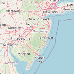
Map view of Delaware National Estuarine Research Reserve

Use this park location map to pinpoint Delaware National Estuarine Research Reserve in United States of America, understand its exact geographic position, and read its mapped placement within the surrounding landscape more clearly.

Pigeon | © OpenStreetMap contributors

Location context for Delaware National Estuarine Research Reserve

DelawareKent County
Park atlas

Compare regional coastal habitats, tidal salt marshes, and connected Mid-Atlantic reserves.

Parks Near Delaware National Estuarine Research Reserve And Surrounding Protected Areas

Browse protected areas near Delaware National Estuarine Research Reserve to compare neighboring coastal reserves, tidal salt marshes, and freshwater wetland systems. Expanding geographic comparison helps visitors evaluate regional conservation landscapes and connected estuarine habitats across the Mid-Atlantic.
A minimalist watercolor painting depicting a soft green and pastel landscape with rolling hills and a central pond or marshy area on a white background.
Protected landscapeMaryland
About 90 km away#1 closest

South

Assateague Island National Seashore: Geographic Atlas and Protected Landscape Overview

Dynamic barrier island terrain in the Maryland region

Assateague Island National Seashore preserves one of the most naturally functioning barrier island ecosystems in the Mid-Atlantic. This protected stretch of coastline showcases the interaction between sediment movement, storm-driven overwash, and salt marsh development, offering a clear view of how barrier systems respond to environmental forces.

Area
167.2 km²
Established
1965
IUCN
V
Visitors
2.3M annual
Nature reserveNew Jersey
About 110 km away#2 closest

Northeast

Jacques Cousteau National Estuarine Research Reserve: New Jersey Coastal Protected Area

Inland-to-ocean ecological gradient map and landscape overview.

Located in southeastern New Jersey, the Jacques Cousteau National Estuarine Research Reserve provides a rare, contiguous protected footprint covering the Mullica River and Great Bay. This landscape includes freshwater swamps, salt marshes, and barrier island dunes, offering a benchmark site for scientific research on estuarine and coastal processes along the Atlantic coast.

Area
470 km²
Established
1997
Relief
Lowland
Climate
Temperate
A watercolor painting showing a soft, stylized view of rolling green hills, trees, and a river flowing through a valley.
Marine protected areaCharles County
About 172 km away#3 closest

Southwest

Mallows Bay, Potomac River National Marine Sanctuary: Mapping the Potomac River Ghost Fleet

A historic marine protected area in Charles County, Maryland.

The Mallows Bay, Potomac River National Marine Sanctuary preserves a significant maritime archaeology site within the Chesapeake Bay watershed. The protected area features the Ghost Fleet of World War I era steamships that have been reclaimed by river ecology. This region offers a distinct look at the intersection of cultural history and tidal freshwater habitats in Southern Maryland.

Area
47 km²
Established
2019
IUCN
V
Relief
Lowland
Watercolor painting of a light, abstract landscape featuring green fields, soft hills in the background, and touches of pink and yellow vegetation.
Protected landscapeNew York
About 193 km away#4 closest

Northeast

Gateway National Recreation Area: A Mapped Guide to Coastal Protected Landscapes

Urban coastal geography and maritime heritage sites

Spanning from the western Rockaway Peninsula to the shores of New Jersey, Gateway National Recreation Area serves as a major ecological anchor. This protected landscape integrates rare maritime habitats, barrier beach systems, and decommissioned military installations into a singular geographic footprint. Use this atlas resource to understand the park's three primary units and their roles in maintaining the natural shoreline of the New York Harbor region.

Area
107.67 km²
Established
1972
IUCN
V
Visitors
8.7M annual
Watercolor illustration depicting a cascading waterfall nestled between rolling green hills and a gentle body of water.
Protected landscapeUnited States of America
About 206 km away#5 closest

North

Delaware Water Gap National Recreation Area: Regional Geography and Mapped Protected Landscapes

Appalachian river corridors and mountain pass geography.

Delaware Water Gap National Recreation Area serves as a major protected unit in the United States, centered on the dramatic geological pass where the Delaware River cuts through Kittatinny Mountain and Blue Mountain. This expansive landscape preserves critical riverine habitats, forested ridges, and historic corridors that provide a deep look into the regional geography of the mid-Atlantic Appalachians.

Area
270.09 km²
Established
1965
Visitors
4.2M annual
Relief
Mountain
Nature reserveVirginia
About 215 km away#6 closest

Southwest

Chesapeake Bay National Estuarine Research Reserve, Virginia: Coastal and Estuarine Atlas

Mapped protected landscapes of the York River estuary.

Spanning the critical salinity gradient of the York River, this nature reserve integrates diverse tidal habitats including expansive marshes, quiet creeks, and coastal islands. As a center for scientific monitoring, the reserve offers a layered view of Mid-Atlantic estuarine geography, protecting essential buffers and water channels that define the lower Chesapeake Bay region.

Established
1991
Relief
Lowland
Climate
Temperate
Access
Access unknown
Watercolor painting of rolling hills, trees, and a river in a scenic landscape
National parkVirginia
About 236 km away#7 closest

West

Shenandoah National Park: National Park Protected Landscape and Geography

Mapped terrain and protected area context in Virginia.

Shenandoah National Park is a designated national park in Virginia, offering a rich exploration of its protected landscape and geographic features. This page provides detailed atlas-oriented information, focusing on the park's mapped boundaries and its role within the regional geography. Discover the natural terrain and spatial identity of this important US protected area, ideal for understanding park landscapes.

Area
811.176 km²
Established
1935
IUCN
II
Visitors
1.7M annual
Protected landscapeNew York
About 255 km away#8 closest

Northeast

Fire Island National Seashore: Geography and Protected Area Exploration

Barrier island ecosystems and coastal wilderness in New York

Fire Island National Seashore spans a narrow, thirty-mile barrier island corridor, protecting a mosaic of maritime pine forest, expansive Atlantic beaches, and quiet bay-side salt marshes. This protected landscape includes the Otis Pike Fire Island High Dune Wilderness and the maritime holly canopy of the Sunken Forest, offering an essential reference for exploring coastal geography in New York.

Area
79.23 km²
Established
1964
IUCN
V
Visitors
393.7K annual

Common questions about visiting, size, designation, and location context for Delaware National Estuarine Research Reserve

Delaware National Estuarine Research Reserve FAQs for park facts, access, geography, and protected area context

Find quick answers about Delaware National Estuarine Research Reserve, including protected-area facts, park geography, trail and visitor context, and how the park fits into its surrounding country and regional landscape.
MoriAtlas Explorer

Continue Your Protected Areas Search Across the Global Atlas

Deepen your exploration by continuing the structured search for national parks and protected areas worldwide. Utilize the comprehensive filtering capabilities to compare different conservation landscapes and refine your understanding of global park geography. Discover more about the distribution and characteristics of protected natural areas.

Global natural geography