Mori Atlas logo
National parkDeux Balés National Park

Discover mapped boundaries and savanna geography of this vital West African conservation area.

Deux Balés National Park: Burkina Faso's Premier Elephant Sanctuary and Protected Landscape

Deux Balés National Park represents a crucial protected area within Burkina Faso, recognized internationally as a significant stronghold for elephants in West Africa. This national park shelters a substantial population of these endangered animals amidst a unique Sudano-Zambezian savanna landscape. Users can explore the park's geographic context, including its undulating granitic plains, lateritic plateaux, gallery forests along the Black Volta River, and the presence of iconic African baobab trees. Understanding Deux Balés National Park offers insight into regional conservation efforts and the mapped distribution of protected lands in West Africa.

national parkelephant sanctuarysavanna ecosystemgallery forestWest AfricaBurkina Faso

Deux Balés National Park

National park

Park overview

Structured park overview, official facts, and landscape profile for Deux Balés National Park

Deux Balés National Park park facts, protected area profile, and essential visitor context

Review the core facts for Deux Balés National Park, including designation, size, terrain, visitor scale, habitats, and operating context in one park-focused overview.

About Deux Balés National Park

Deux Balés National Park occupies a significant position in Burkina Faso's protected area network as the country's premier location for elephant conservation. The park's 810 square kilometer expanse lies in central eastern Burkina Faso within Mouhoun Province, positioned immediately west of the Black Volta River which forms a natural eastern boundary. The landscape consists of an undulating granitic plain with scattered rock outcrops and lateritic plateaux, typical of the Sudano-Zambezian ecological zone that spans much of West Africa's interior. Elevation ranges from 235 to 310 meters above sea level, creating a relatively flat to gently rolling terrain. The park's conservation significance was recognized early in the 20th century when it was designated as a classified forest in 1937 under French colonial rule, making it one of the oldest protected areas in Burkina Faso. The transition to national park status in 1967 reflected growing post-independence interest in wildlife conservation, though the formal legal framework for the park remains incomplete. The park's location along the Black Volta River provides critical habitat for species requiring water access, while the surrounding savanna supports diverse mammal communities including buffaloes, antelopes, and hippopotamuses.

Quick facts and research context for Deux Balés National Park

Deux Balés National Park spans 810 square kilometers in Mouhoun Province, Burkina Faso, at elevations between 235 and 310 meters above sea level. The protected area lies immediately west of the Black Volta River, which forms its eastern boundary. Originally established as a classified forest in 1937 during the French colonial period, the area received national park designation in 1967 but lacks a formal establishing law. The park supports the largest elephant population in West Africa, with approximately 400 individuals recorded by 2001. Vegetation consists of Sudano-Zambezian savanna with gallery forests along watercourses, and the landscape features granitic plains with lateritic plateau formations.

Protection and recognition

Verifying terrestrial conservation frameworks and official management boundaries

Deux Balés National Park Protection Status and Conservation Designation

National park explorers can trace the documented terrestrial protection status and conservation framework established for Deux Balés National Park. Comprehensive geographic mapping of designated boundaries and terrestrial management scopes supports comparative analysis across regional protected areas.

Protection details

Protection scope
Terrestrial
Transboundary protection
No
Park context

Deeper park guide and search-rich context for Deux Balés National Park

Deux Balés National Park history, landscape, wildlife, and travel context

Explore Deux Balés National Park through its history, landscape character, ecosystems, wildlife, conservation priorities, cultural context, and seasonal travel timing in a structured park guide built for atlas discovery and search intent.

Why Deux Balés National Park stands out

Deux Balés National Park is best known as a premier elephant sanctuary in West Africa. The park shelters approximately 400 elephants, representing the largest population of this endangered species in the entire region. This concentration of elephants, combined with the park's status within Burkina Faso's network of protected areas, makes it a critical conservation stronghold for large mammal populations in West Africa. The park's iconic baobab trees, some of which are centuries old, dot the savanna landscape and serve as a distinctive visual特征 of the protected area. The presence of gallery forests along the Black Volta River adds ecological diversity to the predominantly savanna habitat.

Deux Balés National Park history and protected-area timeline

Deux Balés National Park traces its institutional history to the French colonial period in West Africa. In 1937, the area was established as the forêts classées des Deux Balés, or the Deux Balés Classified Forests, covering an initial area of 610 square kilometers within what was then French West Africa. This designation reflected the colonial administration's interest in managing timber resources and controlling land use in environmentally significant areas. Following Burkina Faso's independence in 1960, the newly formed Republic of Upper Volta renamed the protected area as Parc national des Deux Balés in 1967, granting it national park status. However, despite this reclassification, no formal law has ever been enacted to legally establish the park, creating ongoing uncertainty about its protected status. Conservation challenges have persisted throughout the park's history. Poaching activities have threatened wildlife populations, and in 1968 significant reductions in large mammal populations occurred due to culling operations by the veterinary service. By 1989, the International Union for Conservation of Nature had expressed concern about the park's integrity, noting that agricultural and mining activities in the surrounding area conflicted with elephant population conservation. Despite these challenges, by 2001 Burkina Faso held the largest elephant population in West Africa, with Deux Balés and the adjacent Baporo Forest supporting approximately 400 individuals.

Deux Balés National Park landscape and geographic character

The physical landscape of Deux Balés National Park reflects the geology and topography of central eastern Burkina Faso. The park sits within an undulating granitic plain characterized by gentle起伏 that creates a subtly varied terrain across the savanna. Granite outcrops emerge periodically above the general land surface, providing rocky intrusions into the otherwise soft landscape. The lateritic plateaux represent ancient erosion surfaces where iron-rich soils have formed hard caprock that shapes local drainage patterns and vegetation distribution. Elevation ranges narrowly between 235 and 310 meters above sea level, placing the park in a relatively low-lying position within the West African interior. The Black Volta River marks the park's eastern boundary, and its banks support gallery forest vegetation that contrasts sharply with the surrounding savanna. The savanna itself consists of a carpet of grasses punctuated by scattered trees and woodland patches, with the African baobab serving as the most visually distinctive element of the landscape. These ancient trees, with their massive trunks and distinctive silhouettes, have become symbolic of the park's character and are frequently referenced in descriptions of the protected area.

Deux Balés National Park ecosystems, habitats, and plant life

The ecological character of Deux Balés National Park is defined by its position within the Sudano-Zambezian savanna biome, a vegetation zone that covers much of West Africa's interior. The park's vegetation consists primarily of savanna with a continuous ground layer of grasses beneath a scattered tree stratum. Key tree species include Anogeissus leiocarpus, Isoberlinia doka, and Terminalia laxiflora, which form the woodland component of the savanna. Along the Black Volta River, gallery forests develop where moisture availability supports denser tree growth and more complex forest structure. These gallery forests provide habitat for species that require more shaded, humid conditions than the surrounding savanna offers. The Black Volta River itself, with approximately 100 kilometers of its banks protected within the park, represents a critical water source for wildlife and a corridor for species movement. The park's designation as a protected area has helped preserve these habitats despite surrounding agricultural and mining pressures, though the overall diversity of fauna has reportedly declined from historical levels.

Deux Balés National Park wildlife and species highlights

Deux Balés National Park supports a diverse mammal community despite ongoing conservation challenges. The park is most notable for its elephant population, with approximately 400 individuals recorded by the early 2000s, representing the largest concentration of African elephants in West Africa. These elephants rely on the park's savanna habitats and the Black Volta River for water and forage. Other large mammals present include hippopotamuses Hippopotamus amphibius, which utilize the riverine habitats, and African buffaloes Syncerus caffer, which move through the savanna in herds. Various antelope species roam the grasslands and woodland areas, though conservation literature has noted concerns about the long-term survival of these populations without improved management practices. Reptiles including crocodiles are found in the Black Volta River, while the overall faunal diversity has reportedly decreased from historical levels due to poaching and human pressure. The park's significance for large mammals, particularly elephants, remains its primary wildlife value, though the integrity of these populations depends on effective protection and habitat management.

Deux Balés National Park conservation status and protection priorities

Deux Balés National Park holds significant conservation importance as West Africa's premier elephant sanctuary and a critical refuge for large mammals in Burkina Faso. The park's population of approximately 400 elephants represents a substantial portion of West Africa's total elephant numbers, making the protected area essential for regional species conservation. However, the park faces persistent conservation challenges. The lack of formal legal establishment as a national park has created ambiguity about protections and management authority. Poaching activities continue to threaten wildlife populations, and by 1968 significant reductions in large mammal numbers had already occurred. Agricultural expansion and mining activities in the surrounding area create pressure on the park's boundaries and habitat integrity. In 1989, the International Union for Conservation of Nature recommended reviewing the park's legal status in light of these conflicting activities. Gallery forest protection along 100 kilometers of the Black Volta River provides important riparian habitat preservation, while the broader savanna ecosystem requires continued management to maintain the ecological conditions that support the park's wildlife populations.

Deux Balés National Park cultural meaning and human context

Deux Balés National Park exists within a region of Burkina Faso where human communities have traditionally maintained close relationships with the savanna environment. The park's location in Mouhoun Province places it within an area where agricultural communities practice settled farming alongside pastoral activities. The Black Volta River has historically served as both a resource and a boundary for local populations, and the gallery forests along its banks likely hold cultural significance for surrounding communities. The park's establishment as a classified forest in 1937 under French colonial administration introduced formal protected area concepts to the landscape, creating a conservation framework that overlay existing land use patterns. The transition to national park status in 1967 reflected post-colonial national priorities around wildlife protection, though the incomplete legal process has left the park's status ambiguous. Conservation efforts have recognized that effective protection requires addressing the needs and practices of local communities, as noted in discussions about antelope population survival requiring improvements beyond legal protection alone.

Top sights and standout views in Deux Balés National Park

Deux Balés National Park stands as the most important elephant conservation area in West Africa, sheltering approximately 400 individuals representing the largest regional population. The park's ancient baobab trees, some reaching hundreds of years old, create an iconic savanna landscape that defines the protected area's visual identity. Gallery forests extending along 100 kilometers of the Black Volta River provide critical habitat diversity and water access for wildlife. As one of Burkina Faso's oldest protected areas, established in 1937 as classified forests, the park represents decades of conservation legacy in the Sudano-Zambezian savanna zone. The undulating granitic landscape with lateritic plateaux offers a distinctive physical setting that differs from the more mountainous protected areas in the region. The park's conservation challenges, including poaching and incomplete legal status, highlight ongoing tensions between wildlife protection and development pressures in West Africa.

Best time to visit Deux Balés National Park

Visiting Deux Balés National Park is best during the dry season from November to April when wildlife congregates more visibly around water sources and vegetation is less dense, making animal observation easier. The dry months offer clearer landscapes and more accessible trails through the savanna, though temperatures can be warm. The wet season from May to October transforms the landscape with fresh vegetation and migratory bird activity, but some areas may become difficult to access and wildlife more dispersed. The Black Volta River remains a consistent attraction year-round, providing wildlife viewing opportunities regardless of season. Peak elephant activity occurs during the cooler dry months when animals regularly visit the river to drink and bathe.

Monthly climate preview

Decadal temperature gradients and historical precipitation cycles in Burkina Faso

Monthly Climate Normals and Weather Patterns in Deux Balés National Park

Long term meteorological records from a representative elevation of 288 meters reveal a distinct annual sequence of high daytime temperatures peaking over 42 degrees Celsius alongside a highly concentrated seasonal precipitation pattern. Accessing the full profile reveals twelve-month details for daily averages, minimum and maximum spans, and long-term weather by month trends.
Annual mean28 °C
24 °C32 °C
Jan25°
Feb28°
Mar31°
Apr32°
May31°
Jun29°
Jul27°
Aug26°
Sep26°
Oct27°
Nov26°
Dec24°
Warmest month
April

32 °C

Coolest month
December

24.5 °C

Wettest month
August

8.1 mm/day

Driest month
December

0 mm/day

Park location guide

Geography guide, regional context, and park location map for Deux Balés National Park

Deux Balés National Park park geography, regions, and map view in Burkina Faso

Understand where Deux Balés National Park sits in Burkina Faso through a broader geographic reading of the surrounding landscape, nearby location context, and its mapped position within the national park landscape.

How Deux Balés National Park fits into Burkina Faso

Burkina Faso is a landlocked West African nation. The Mossi people settled the area in the 11th and 13th centuries, establishing kingdoms such as Ouagadougou, Tenkodogo, and Yatenga. The French colonized the region in 1896 as part of French West Africa, and the country gained independence in 1960 as the Republic of Upper Volta before being renamed Burkina Faso in 1984 by President Thomas Sankara.

Wider geography shaping Deux Balés National Park in Burkina Faso

Burkina Faso is a landlocked country in West Africa, bordered by Mali to the northwest, Niger to the northeast, Benin to the southeast, Togo and Ghana to the south, and Ivory Coast to the southwest. The terrain consists primarily of a peneplain with some laterite plateaus in the southeast. The country has several major rivers including the Mouhoun, Nakambe, and Comoé, though most are seasonal.

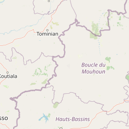
Map view of Deux Balés National Park

Use this park location map to pinpoint Deux Balés National Park in Burkina Faso, understand its exact geographic position, and read its mapped placement within the surrounding landscape more clearly.

Pigeon | © OpenStreetMap contributors

Location context for Deux Balés National Park

Mouhoun Province
Park atlas

Trace West Africa's regional park geography, compare savanna ecosystems, and explore contiguous protected landscapes.

Discover More National Parks and Protected Areas Near Deux Balés National Park

Continue your atlas exploration from Deux Balés National Park to browse other national parks and protected areas across Burkina Faso and the broader West African savanna ecosystems. Compare diverse conservation landscapes, map regional elephant sanctuaries, and trace the spread of unique gallery forests along river systems.
Wildlife reserveUpper West Region
About 151 km away#1 closest

Southeast

Gbele Resource Centre Wildlife Reserve: A Regional Atlas of Protected Savanna Landscapes

Mapped geography and protected woodland in Ghana

Gbele Resource Centre represents one of the most substantial protected savanna landscapes in northwestern Ghana, spanning over 500 square kilometres of Sudano-Sahelian woodland. The terrain is defined by the seasonal Kulpawn River and a distinct composition of African baobab and sycamore fig trees, which together anchor an important ecological corridor. This reserve provides a vital opportunity to map and understand the conservation geography and avian diversity that distinguish the Upper West Region from other parts of the country.

Area
565 km²
Relief
Lowland
Scope
Terrestrial
Water
Minor water
Protected areaBurkina Faso
About 169 km away#2 closest

West

Forêt classée de Kou: Protected Gallery Forest and Riverine Geography in Burkina Faso

A compact biodiversity refuge near Bobo-Dioulasso

Forêt classée de Kou stands as a vital example of Guinean-type forest preservation in Burkina Faso. This protected area features a complex mosaic of dense gallery woodland along the Kou and Guinguette rivers, transitioning into arborescent savanna. With its layered canopy, riverine corridors, and documented avian richness, it serves as a critical geographic marker of humid woodland in the broader Sudano-Sahelian terrain.

Area
1.15 km²
Established
1951
Climate
Tropical
Access
Easy access
Watercolor depiction of a river flowing through a landscape with green trees and distant mountains under a light sky
National parkBurkina Faso
About 171 km away#3 closest

East

Kaboré Tambi National Park: Burkina Faso's Largest National Park and Protected Landscape

Explore the mapped savanna and birdwatching geography of this vital West African area.

Kaboré Tambi National Park represents a critical protected area in Burkina Faso, spanning a considerable expanse of Sudan-Guinea savanna. The park's geography is defined by the Nazinon River and a mosaic of woodland and grassland ecosystems, making it a significant site for understanding regional protected lands and landscape ecology. It offers a valuable point of reference for atlas-based exploration of West African natural areas.

Area
1,555 km²
Established
1976
IUCN
II
Relief
Lowland
Nature reserveOubritenga
About 199 km away#4 closest

Northeast

Forêt classée de Gonsé Nature Reserve: Protected Landscape and Geographic Atlas Record

Sudano-Sahelian woodland and Massili River floodplain context

Examine the protected landscape of Forêt classée de Gonsé, a nature reserve in the Oubritenga region of Burkina Faso. This record details the park's savanna recovery, riverine habitats, and the legacy of its reforestation history as part of the West African Sudano-Sahelian interface.

Relief
Lowland
Climate
Subtropical
Access
Easy access
Scope
Terrestrial
Wildlife reserveUpper West Region
About 215 km away#5 closest

South

Wechiau Community Hippo Sanctuary: Protected River Landscapes and Savanna Wildlife Reserve

Upper West Region, Ghana: Riverine ecology and community-managed boundaries

Wechiau Community Hippo Sanctuary encompasses a protected stretch of the Black Volta, providing essential habitat for hippopotamuses in northwestern Ghana. This wildlife reserve features a diverse landscape of riverine forests, sandbanks, and savanna trails. The sanctuary demonstrates how local traditional governance maintains critical natural terrain while fostering an integrated cultural and ecological landscape.

Established
1999
Relief
Lowland
Scope
Terrestrial
Water
Major water bodies
National parkSavannah Region
About 228 km away#6 closest

Southeast

Mole National Park: A Premier Protected Landscape in Ghana's Savannah Region

Explore mapped boundaries and Guinea savannah ecosystems.

Mole National Park represents a significant protected landscape within Ghana's Savannah Region, serving as the country's largest national park and a crucial conservation area for West African wildlife. The park's geography is defined by extensive Guinea savannah, characterized by grasslands with scattered woodlands and a prominent escarpment along its southern edge. Its vast expanse offers a unique opportunity to study mapped park boundaries and understand the ecosystem's role in regional conservation efforts. Discover the unique landscape context and protected area identity of this major West African wildlife refuge.

Area
4,840 km²
Established
1958
IUCN
II
Visitors
17.8K annual
Protected areaCascades
About 233 km away#7 closest

Southwest

Lac de Tengréla Protected Area: Mapping Wetland Landscapes in the Cascades Region

Freshwater geography and regional catchment in southwestern Burkina Faso

Located near Banfora, Lac de Tengréla functions as a protected Ramsar wetland within the Comoé River system. This freshwater lake provides essential ecological value, with its elongated basin and outflow connectivity offering a distinct window into the hydrology and natural terrain of southwestern Burkina Faso.

Area
5.8 km²
Established
2009
Scope
Terrestrial
Water
Water-dominated
Watercolor illustration of a landscape with green fields, trees, and a body of water
National parkIvory Coast
About 237 km away#8 closest

South

Comoé National Park: Geographic and Environmental Overview of the Ivory Coast Reserve

Mapping the transitions of West Africa's largest protected savanna ecosystem.

Comoé National Park serves as an ecological crossroads in north-eastern Ivory Coast, protecting 11,500 square kilometers of diverse terrain. The park hosts an extraordinary gradient of habitats, from dense gallery forests hugging the 230 kilometer stretch of the Comoé River to open, dry Sudanian savannas. Its geological foundation, featuring dramatic granite inselbergs and wide plains, supports a highly complex network of life, making it a cornerstone for understanding West African regional conservation and landscape ecology.

Area
11,500 km²
Established
1983
IUCN
II
Relief
Lowland

Common questions about visiting, size, designation, and location context for Deux Balés National Park

Deux Balés National Park FAQs for park facts, access, geography, and protected area context

Find quick answers about Deux Balés National Park, including protected-area facts, park geography, trail and visitor context, and how the park fits into its surrounding country and regional landscape.
MoriAtlas Explorer

Continue Your Protected Areas Search Across the Global Atlas

Deepen your exploration by continuing the structured search for national parks and protected areas worldwide. Utilize the comprehensive filtering capabilities to compare different conservation landscapes and refine your understanding of global park geography. Discover more about the distribution and characteristics of protected natural areas.

Global natural geography