Mori Atlas logo
Nature reserveDolgensee

A detailed geographic study of wetland habitats, lake basins, and inland dune ecosystems

Dolgensee Nature Reserve: Mapped Protected Landscapes and Regional Geography in Brandenburg, Germany

(Naturschutzgebiet Dolgensee)

Dolgensee Nature Reserve protects a nutrient-rich lake basin and its extensive reed, sedge, and alder swamp ecosystems in the Brandenburg region of Germany. This protected area stands out for its unusual transition from aquatic wetlands to dry inland dune grassland within a compact, near-natural landscape. Explore the hydrological connectivity of the Dahme River through the reserve and understand its regional role as a critical refuge for diverse waterbird and aquatic species.

nature reservelakewetlandreedbedalder swampwet meadow

Dolgensee

Nature reserve

Park overview

Structured park overview, official facts, and landscape profile for Dolgensee Nature Reserve

Dolgensee Nature Reserve park facts, protected area profile, and essential visitor context

Review the core facts for Dolgensee Nature Reserve, including designation, size, terrain, visitor scale, habitats, and operating context in one park-focused overview.

About Dolgensee Nature Reserve

Dolgensee Nature Reserve is a compact but ecologically rich protected area in the Brandenburg countryside southeast of Berlin. The reserve centers on the shallow lake Dolgensee, through which the Dahme River flows, and extends across the surrounding marshlands, meadows, and slightly drier sandy habitats on its flanks. The protected area stretches roughly between the villages of Gussow to the northwest and Dolgenbrodt to the southeast, both parts of the Heidesee municipality, with the federal highway B246 running along its southern edge.

Administratively, Dolgensee falls within the Dahme-Spreewald district in the state of Brandenburg and is part of the broader Dahme-Heideseen Nature Park, a region known for its chains of glacial lakes, pine forests, and inland dunes shaped by the Weichselian glaciation. Within this wider landscape, the Dolgensee reserve stands out for the intactness of its shoreline: large sections of the lake's edge remain free of development, allowing a near-natural transition from open water through reedbeds and sedge marshes into wet woodland and meadow.

The reserve was placed under formal protection by an ordinance of the state of Brandenburg dated 9 June 1995, and it has since been incorporated into the European Natura 2000 ecological network as a designated Habitats Directive (FFH) site. This dual status reflects both its national importance as a Brandenburg nature reserve and its place within a coherent European system for safeguarding rare habitats and species.

The defining character of Dolgensee is the way its lake-centered wetland ecosystem grades into adjacent terrestrial habitats, producing a mosaic that supports a wide range of plants and animals. Beyond its ecological role, the reserve has regional value for landscape conservation in the transition zone between the Spreewald wetland complex and the lake districts south of Berlin.

Quick facts and research context for Dolgensee Nature Reserve

Dolgensee Nature Reserve (NSG Dolgensee) is located in the municipality of Heidesee, Dahme-Spreewald district, Brandenburg, Germany, and lies within the Dahme-Heideseen Nature Park. The protected area covers roughly 308 hectares and protects the lake Dolgensee together with surrounding reedbeds, alder swamp, wet meadows, and dry sandy grassland.

The site was formally placed under protection by ordinance on 9 June 1995 and is administered by the Brandenburg State Office for the Environment. It is also designated as a Natura 2000 Habitats Directive (FFH) site, with an area of about 303 hectares, recognized for its lake habitats, shoreline vegetation, and importance for wetland-dependent species.

Protection and recognition

Terrestrial protected area framework and international Natura 2000 records

Dolgensee Protection Status and Documented Conservation Recognition

Terrestrial conservation records detail the official protection status and formal Natura 2000 designations established for Dolgensee. Structured database metrics outline the documented management scope and administrative recognition data associated with this protected area.

International recognition

Protection details

Protection scope
Terrestrial
Transboundary protection
No
WDPA ID
162769
Park context

Deeper park guide and search-rich context for Dolgensee Nature Reserve

Dolgensee Nature Reserve history, landscape, wildlife, and travel context

Explore Dolgensee Nature Reserve through its history, landscape character, ecosystems, wildlife, conservation priorities, cultural context, and seasonal travel timing in a structured park guide built for atlas discovery and search intent.

Why Dolgensee Nature Reserve stands out

Dolgensee is best known for being a nutrient-rich shallow lake bordered by extensive reed and sedge belts, set within an unusually varied mix of wet and dry habitats for an inland Brandenburg site. The combination of open water, tall stands of reeds and floating-leaf vegetation, alder swamp woodland, and rare patches of inland dune grassland gives the reserve a notably high habitat diversity within a compact protected area. Its largely unbuilt shoreline and ecological richness have made it valued as a regional wintering ground for waterbirds and as a refuge for wetland-dependent wildlife, including aquatic reptiles and mammals such as the European otter.
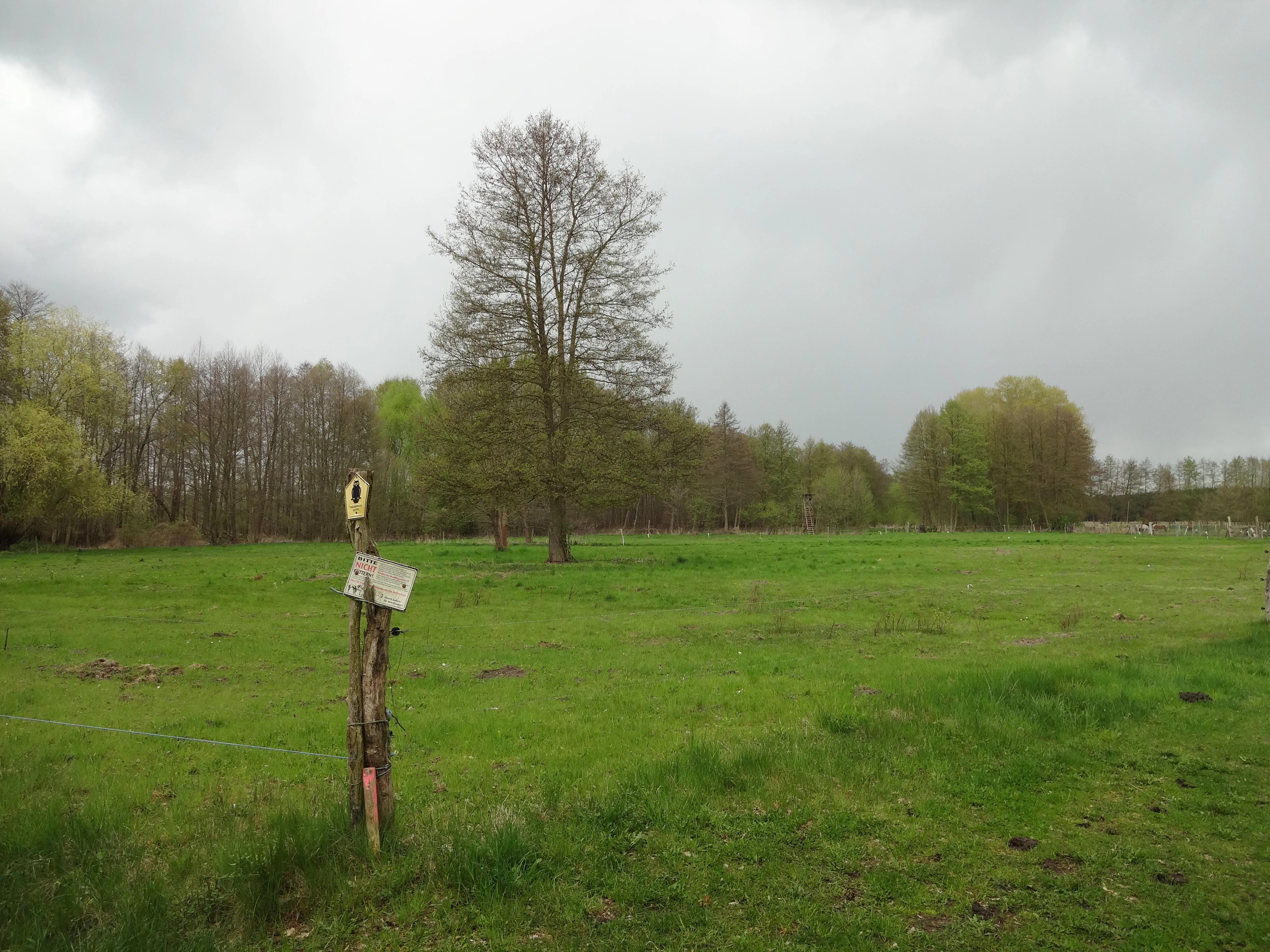
A rustic wooden post with a trail marker sign stands in the foreground of a grassy field, with a line of trees in the background under an overcast sky.
A trail marker standing in a grassy meadow at the Dolgensee Nature Reserve.

Dolgensee Nature Reserve history and protected-area timeline

The Dolgensee Nature Reserve was formally established on 9 June 1995 by an ordinance of the state of Brandenburg, with the designation 'Naturschutzgebiet Dolgensee' under the identifier 1207. The purpose of the ordinance was to safeguard the lake and its surrounding habitats as a near-intact landscape with largely undeveloped shoreline, regional importance for overwintering waterbirds, and significant stands of rare shoreline plant communities.

Following its initial designation, the area was integrated into the European Natura 2000 network as a Habitats Directive (FFH) site under the designation DE-3748-301. The Federal Agency for Nature Conservation (Bundesamt für Naturschutz) maintains a standardized site profile for the area, confirming its value within the broader pan-European effort to maintain coherent networks of protected habitats. Management responsibility lies with the Brandenburg State Office for the Environment, specifically its ecology, nature conservation, and water division.

Dolgensee Nature Reserve landscape and geographic character

The landscape of the Dolgensee reserve is dominated by a shallow, nutrient-rich lake bordered by a nearly continuous belt of wetland vegetation. The lake is fed and drained by the Dahme River, which threads through the water body and defines the hydrological character of the site. Along much of the shoreline, dense reedbeds of common reed give way to broad sedge stands, floating-leaf vegetation, and patches of wet woodland dominated by alder, forming a soft transition from open water to land.

Inland from the lake, the terrain rises slightly into drier ground that supports a contrasting set of habitats. Here, open grassland communities characteristic of inland dunes, including silvergrass and bentgrass stands, appear alongside moister meadows and tall-herb floodplain vegetation. This juxtaposition of wet shoreline ecosystems with dry sandy grassland within a single reserve is unusual and is a defining feature of the protected area's visual character.

The broader landscape context is shaped by the glacial history of the region. The Dahme-Seenland area east of the Spreewald is marked by chains of lakes, low hills, and relict dunes left by retreating ice sheets, and the Dahme-Heideseen Nature Park, of which the reserve is a part, preserves much of this character. Within this regional setting, Dolgensee offers a particularly fine example of a lake basin retained in a near-natural state.

Dolgensee Nature Reserve ecosystems, habitats, and plant life

The ecological character of Dolgensee is defined by the interaction between its nutrient-rich lake water and the surrounding mosaic of wetland and dry habitats. The lake itself is classified as a natural or near-natural nutrient-rich standing water body, hosting pondweed and frogbit aquatic plant communities typical of lowland Brandenburg lakes. Its productivity supports extensive floating and emergent vegetation along the margins.

Bordering the lake, the reserve preserves a layered shoreline system of tall reedbeds, broad stands of large sedges, tall-herb communities along the floodplain of the Dahme, and alder swamp woodland on permanently moist ground. Moving slightly inland, wet meadows and alternating moist and dry grasslands provide further habitat transitions, while patches of dry inland dune grassland with silvergrass and bentgrass represent the driest, most ecologically distinctive element of the reserve.

This diversity within a relatively small area gives the site its ecological significance. The combination of open water, shoreline vegetation, wet woodland, and dry grassland creates a gradient of moisture and substrate conditions that sustains a wide array of plant communities recognized under the European Habitats Directive, including wet tall-herb floodplain vegetation and nutrient-rich standing waters with pondweed or frogbit associations.

Dolgensee Nature Reserve wildlife and species highlights

The wildlife interest of Dolgensee centers on its importance for waterbirds and other wetland-dependent species. The reserve is recognized as a regional wintering area for waterfowl, taking advantage of the open water and undisturbed shoreline, and serves as both a breeding and feeding habitat for a variety of songbirds and larger bird species. The combination of open water, reedbeds, and adjacent meadows supports a mix of aquatic, marshland, and grassland bird communities.

Beyond birds, the reserve functions as a refuge for reptile and mammal species tied to aquatic and wetland habitats. The European otter (Lutra lutra) is listed among the species of conservation importance found in the area, reflecting the intact nature of the shoreline and surrounding wetlands. The reserve also provides habitat for two fish species protected under the Habitats Directive: the asp (Aspius aspius) and the bitterling (Rhodeus amarus), both of which require well-structured, vegetated freshwater environments.

The mosaic of wet and dry habitats supports a broader community of wetland-associated fauna, and the largely undeveloped shoreline is an important factor in maintaining conditions suitable for sensitive species that have declined elsewhere in more intensively used lowland landscapes of central Europe.

Dolgensee Nature Reserve conservation status and protection priorities

Dolgensee is protected at two complementary levels: as a national nature reserve under Brandenburg law and as a site within the European Natura 2000 network. The 1995 ordinance establishing the reserve identifies its core purposes as safeguarding rare and threatened shoreline plant communities, particularly the extensive reeds and floating-leaf vegetation of the Dolgensee, the alder swamp communities, the alternating moist meadows, and the dry grassland stands, together with the conservation of animal species dependent on these habitats.

At the European level, the site contributes to Natura 2000, the coherent EU-wide network of protected areas. As a Habitats Directive (FFH) site, it is included for the conservation of natural and near-natural nutrient-rich standing waters, wet tall-herb floodplain vegetation, and dry inland dune grasslands, and for the protection of species listed under Annex II of the directive, including the otter, the asp, and the bitterling.

The value of the reserve for conservation lies largely in its degree of intactness. Largely unbuilt shorelines, a continuous transition from open water to wet woodland and dry grassland, and the retention of traditional wet meadows all combine to maintain ecological processes that have been heavily modified elsewhere in the lowlands of northeastern Germany. The site also contributes regional connectivity within the Dahme-Heideseen Nature Park and the broader Spreewald-Dahme lake landscape.

Dolgensee Nature Reserve cultural meaning and human context

The Dolgensee reserve lies within the Heidesee municipality, an area shaped by long-standing patterns of small-scale farming, fishing, and seasonal use of lake and wetland resources that are characteristic of the Brandenburg countryside southeast of Berlin. The communities of Gussow and Dolgenbrodt, which flank the reserve, are part of a network of small rural settlements historically tied to the lakes and forests of the Dahme-Seenland.

The wider landscape falls within the Dahme-Heideseen Nature Park, a region whose identity combines glacial lake scenery, inland dunes, and traditional land use. Although the nature reserve itself is designated primarily for ecological reasons rather than for cultural heritage, its existence reflects regional efforts to maintain the character of this lake-and-forest cultural landscape and to preserve traditional features such as wet meadows and undeveloped shorelines that are integral to the area's identity.

Top sights and standout views in Dolgensee Nature Reserve

Dolgensee Nature Reserve protects a rare combination of nutrient-rich shallow lake, extensive reed and sedge belts, alder swamp, wet meadows, and inland dune dry grassland within a single compact site. It is recognized at both national and European levels through its status as a Brandenburg nature reserve and as a Natura 2000 Habitats Directive site, with formally protected species including the otter, the asp, and the bitterling.

The reserve's largely unbuilt shoreline and its position within the Dahme-Heideseen Nature Park make it a particularly valuable refuge for waterbirds, songbirds, and aquatic wildlife in a heavily modified lowland landscape, and it stands out as an unusually well-preserved example of a Brandenburg lake basin in its near-natural setting.

Best time to visit Dolgensee Nature Reserve

Dolgensee Nature Reserve is best appreciated in the warmer months, when reedbeds, wet meadows, and dune grasslands are in full growth and bird activity around the lake is at its peak. Late spring and early summer typically offer the richest combination of flowering shoreline vegetation and active birdlife, while the open water and undeveloped shoreline make the lake attractive for waterfowl observation into autumn and winter.

Because the reserve is a designated protected area, visitors should plan to experience it primarily through quiet walks along its margins or from designated viewpoints rather than through active recreation on the lake, allowing the habitats that give the site its conservation value to remain undisturbed across the seasons.

Monthly climate preview

Long term representative point measurements and monthly weather patterns in Brandenburg

Dolgensee Climate Normals, Annual Temperature and Precipitation Rhythm

Dolgensee registers a measured annual temperature and precipitation rhythm across twelve recorded intervals, tracking long term averages from winter lows to summer maximums. Reviewing the complete monthly profile provides detailed context on temperature ranges and precipitation rates for this protected area coordinate.
Annual mean10 °C
-1 °C21 °C
Jan-1°
Feb
Mar
Apr
May14°
Jun18°
Jul21°
Aug20°
Sep15°
Oct
Nov
Dec
Warmest month
July

20.6 °C

Coolest month
January

-0.8 °C

Wettest month
July

2.5 mm/day

Driest month
April

1.1 mm/day

Park location guide

Geography guide, regional context, and park location map for Dolgensee Nature Reserve

Dolgensee Nature Reserve park geography, regions, and map view in Germany

Understand where Dolgensee Nature Reserve sits in Germany through a broader geographic reading of the surrounding landscape, nearby location context, and its mapped position within the national park landscape.

How Dolgensee Nature Reserve fits into Germany

Germany is a federal republic in Western and Central Europe with a population of over 83 million across sixteen constituent states. It is Europe's largest economy by nominal GDP and a major global exporter and importer. The capital is Berlin, and the country borders Denmark, Poland, Czech Republic, Austria, Switzerland, France, Luxembourg, Belgium, and the Netherlands.

Wider geography shaping Dolgensee Nature Reserve in Germany

Germany is located in Western and Central Europe, spanning 357,022 km². It borders Denmark to the north, Poland and the Czech Republic to the east, Austria and Switzerland to the south, and France, Luxembourg, Belgium, and the Netherlands to the west. The country has coastlines on the Baltic Sea and North Sea to the north, with the Alps located in the southern region.

Map view of Dolgensee Nature Reserve

Use this park location map to pinpoint Dolgensee Nature Reserve in Germany, understand its exact geographic position, and read its mapped placement within the surrounding landscape more clearly.

Pigeon | © OpenStreetMap contributors

Location context for Dolgensee Nature Reserve

BrandenburgLandkreis Dahme-Spreewald

Explore the unique terrain, shallow lake shores, and diverse habitats defining this Brandenburg nature reserve.

Dolgensee Photos and Landscape Scenery: Visualizing the Protected Wetland Habitat

Visual records capture the distinctive mosaic of open water, dense reedbeds, and adjacent inland dune grasslands that characterize the protected area. Examining these environmental details provides a clearer understanding of the ecological transition zones and regional lake basin geography.

A rustic wooden post with a trail marker sign stands in the foreground of a grassy field, with a line of trees in the background under an overcast sky.

Park atlas

Compare adjacent wetland reserves, lake basins, and regional conservation areas

Explore Parks Near Dolgensee and Related Protected Landscapes in Eastern Germany

Browsing other protected areas near Dolgensee reveals the broader network of wetland habitats and lake basins across eastern Germany. Comparing these surrounding reserves provides valuable regional context for regional wildlife migration and lowland ecosystem preservation.
A horizontal watercolor illustration depicting a soft, serene landscape with green trees, pink flowering trees, and gentle hills on a white background.
Nature reserveBrandenburg
3.1 km away#1 closest

North

Skabyer Torfgraben Nature Reserve: Geographic Mapping and Protected Area Overview

Wetland landscape corridors within Brandenburg, Germany

The Skabyer Torfgraben nature reserve provides a focused look at lowland stream ecosystems and rare through-flow peatland remnants. This protected area in the Dahme-Spreewald region serves as a crucial habitat mosaic, blending sandy birch-oak forests with sedge-dominated wet meadows. Examine its natural terrain and hydrological connections to the Dahme river within the context of German protected landscapes.

Area
3.049 km²
Established
1998
IUCN
IV
Relief
Lowland
Nature reserveBrandenburg
4.3 km away#2 closest

South

Katzenberge Nature Reserve: An Atlas of Glacial Moraine Woodlands in Brandenburg Germany

Protected oak forest habitats within the Dahme-Spreewald landscape

Katzenberge offers a focused look at the conservation of mature deciduous forest environments on sandy moraine soils. As a designated nature reserve within the Brandenburg region, the area serves as a primary reference point for studying habitat continuity and the unique glacial terrain that defines the south-eastern lowlands near the Dahme river.

Area
1.44 km²
Established
2004
IUCN
IV
Relief
Upland
Nature reserveBrandenburg
6.1 km away#3 closest

Northwest

Tiergarten Nature Reserve: Geography and Protected Habitat Mapping in Brandenburg, Germany

Ancient oak woodland, riparian wetlands, and historic forest trails.

Spanning 158 hectares, the Tiergarten nature reserve serves as an ecologically rich sanctuary of oak-hornbeam forests and wet meadows. This area, formerly a royal hunting ground, offers a dense mosaic of riparian zones along the Staabe river, protecting essential habitats within the broader Brandenburg landscape.

Area
1.58 km²
Established
1995
IUCN
IV
Nature reserveBrandenburg
About 6.6 km away#4 closest

South

Streganzsee-Dahme Nature Reserve: Mapping Brandenburg Protected River Landscapes and Dunes

An ecological mosaic in the Dahme-Spreewald river corridor

Streganzsee-Dahme represents an intact Brandenburg riverine corridor characterized by sharply varied topography. The reserve encompasses water bodies, floodplain forests, fens, and dry sandland heaths. Its protected boundaries connect various biotopes, offering an essential look at the region's diverse lowland ecology and the structured geography of the local conservation network.

Area
4.36 km²
Established
1999
IUCN
IV
Relief
Lowland
Nature reserveBrandenburg
7.6 km away#5 closest

South

Stintgraben Nature Reserve: Protected Stream Landscapes in Southern Brandenburg

Ecological connectivity between glacial lakes and river corridors.

Located in the Dahme-Spreewald district, Stintgraben is a protected stream corridor defined by its lowland riparian habitats and position between the Klein Köriser See and the Dahme river. This nature reserve provides essential ecological continuity within the broader Dahme-Heideseen region, offering a clear example of how small-scale protected areas maintain the natural integrity of Germany's glacial lake districts.

Area
1.09 km²
Established
1995
IUCN
IV
Nature reserveBrandenburg
8 km away#6 closest

East

Groß Schauener Seenkette Nature Reserve: Mapped Wetlands and Brandenburg Lake Geography

An undisturbed chain of shallow lakes and protected fen landscapes

This protected nature reserve in Brandenburg preserves a vital chain of six interconnected lakes. The geography is defined by extensive reedbeds, sedge stands, and rare inland saline meadows, providing a crucial habitat mosaic. Learn how these wetlands connect to the surrounding Dahme-Heideseen region through a network of terrain-focused conservation areas and historic trails.

Area
21.249 km²
Established
2000
Relief
Lowland
Climate
Temperate
Nature reserveBrandenburg
8.9 km away#7 closest

Northeast

Swatzke- und Skabyberge Nature Reserve and Protected Inland Dune Geography in Brandenburg

Mapping the sand heaths and forest ecosystems of northeastern Germany

Swatzke- und Skabyberge is a designated nature reserve in Brandenburg that preserves a rare inland dune complex. Originally shaped by long term military usage, this protected land now functions as a vital habitat for dry acid grasslands, lichen-rich pine forests, and wetland woodland fringes. It provides a unique study in how sand, fire, and moisture processes maintain biodiversity within the lowland German landscape.

Area
5.2 km²
Established
1999
IUCN
IV
Nature reserveBrandenburg
9.8 km away#8 closest

Southwest

Naturschutzgebiet Löptener Fenne, Wustrickwiesen: Mapped Geography and Protected Landscapes

Glacial mire and wetland systems in Brandenburg, Germany

The Naturschutzgebiet Löptener Fenne, Wustrickwiesen nature reserve provides a critical look at terrestrialized mire landscapes. Beneath its surface lie deep layers of lake-derived mud, marking this site as a key reference for understanding glacial meltwater history in eastern Germany. Today, the area serves as a focal point for active peatland renaturation and habitat management within the Dahme-Spreewald district.

Area
2.18 km²
Established
1998
IUCN
IV
Relief
Lowland

Common questions about visiting, size, designation, and location context for Dolgensee Nature Reserve

Dolgensee Nature Reserve FAQs for park facts, access, geography, and protected area context

Find quick answers about Dolgensee Nature Reserve, including protected-area facts, park geography, trail and visitor context, and how the park fits into its surrounding country and regional landscape.
MoriAtlas Explorer

Continue Your Protected Areas Search Across the Global Atlas

Deepen your exploration by continuing the structured search for national parks and protected areas worldwide. Utilize the comprehensive filtering capabilities to compare different conservation landscapes and refine your understanding of global park geography. Discover more about the distribution and characteristics of protected natural areas.

Global natural geography