
Mori Atlas logo
Nature reserveRezerwat przyrody Dolina Żabnika

Mapping the peatland, marsh, and forest ecosystems within the Jaworzno protected corridor

Rezerwat przyrody Dolina Żabnika: A Detailed Atlas of Protected Stream Valley Landscapes

Rezerwat przyrody Dolina Żabnika preserves a compact and ecologically dense stream valley in the Silesian Voivodeship of southern Poland. This nature reserve serves as a critical geographic reference point, protecting a continuous sequence of water, peat-forming bogs, and mixed woodland habitats within the Pagóry Jaworznickie. The mapped boundaries provide a clear look at how small drainage basins maintain stability for rare aquatic fauna and specialized bog flora in an urbanized region.

water nature reservestream valleypeatlandlow moortransitional bogwetland habitats
Vector-style graphic illustration featuring stylized pink and purple mountain cliffs, a central waterfall, and green evergreen trees in the foreground against a sunset sky.

Rezerwat przyrody Dolina Żabnika

Nature reserve

Park overview

Structured park overview, official facts, and landscape profile for Rezerwat Przyrody Dolina Żabnika

Rezerwat Przyrody Dolina Żabnika park facts, protected area profile, and essential visitor context

Review the core facts for Rezerwat Przyrody Dolina Żabnika, including designation, size, terrain, visitor scale, habitats, and operating context in one park-focused overview.

About Rezerwat Przyrody Dolina Żabnika

Rezerwat Przyrody Dolina Żabnika is a compact but ecologically rich nature reserve in southern Poland, centered on the valley of the Żabnik stream in the eastern outskirts of Jaworzno. Although small in geographic terms, it is recognized locally as an unusually valuable natural area because it brings together several sensitive habitat types within a single, clearly defined drainage basin.

The reserve lies within the Pagóry Jaworznickie mesoregion, a landscape of low hills and forested uplands typical of the northern fringes of the Silesian Upland. The protected zone follows the natural course of the Żabnik, capturing its watercourse, associated wetlands, peatlands, and the surrounding bands of forest. Because the reserve follows an entire stream valley rather than a single patch, it preserves a continuous ecological gradient from wet, waterlogged peat-forming communities through marsh vegetation to drier pine and mixed woodland on the valley slopes.

Ecologically, Dolina Żabnika is defined by this gradient. Aquatic and peatland plant communities dominate the valley floor, while coniferous and mixed forests frame the edges. Botanical inventories have recorded hundreds of vascular plant species and a substantial bryophyte flora, including legally protected plants and a notable share of species that are regionally rare or threatened. The combination of mountain, bog, forest, and aquatic species in such a small area is unusual for this part of Silesia and is the core reason the site received formal protection.

Beyond its conservation significance, the reserve also serves as a local point of interest for nature education and for understanding how small lowland stream valleys can function as refuges for biodiversity even in heavily industrialized and urbanized regions. Its proximity to the city of Jaworzno gives it additional importance as an accessible example of intact aquatic and peatland habitats in an otherwise transformed regional landscape.

Quick facts and research context for Rezerwat Przyrody Dolina Żabnika

Dolina Żabnika is a water-type nature reserve situated in Jaworzno, in the Pagóry Jaworznickie mesoregion of southern Poland. Created in 1996 by decision of the Katowice regional governor, it covers roughly 48 hectares of protected area surrounded by a larger buffer zone of around 214 hectares. The reserve sits within the upper valley of the Żabnik stream and is managed under active conservation measures.

Its purpose is to safeguard aquatic biocenoses, low peat bogs, and transitional mires along with their rare and legally protected species. The protected landscape combines open water, marshy and peat-forming vegetation with surrounding pine and mixed forests, making it an unusually rich ecological mosaic for its size within the Silesian Voivodeship.

Protection and recognition

Examine documented protection metrics and official conservation status details.

Rezerwat przyrody Dolina Żabnika Protection Status and Terrestrial Conservation Scope

Rezerwat przyrody Dolina Żabnika maintains a documented terrestrial protection scope within its registered regional boundary. Structured conservation records provide factual insight into the management framework and baseline designation status.

Protection details

Protection scope
Terrestrial
Transboundary protection
No
Buffer area
2.14 km²
Park context

Deeper park guide and search-rich context for Rezerwat Przyrody Dolina Żabnika

Rezerwat Przyrody Dolina Żabnika history, landscape, wildlife, and travel context

Explore Rezerwat Przyrody Dolina Żabnika through its history, landscape character, ecosystems, wildlife, conservation priorities, cultural context, and seasonal travel timing in a structured park guide built for atlas discovery and search intent.

Why Rezerwat Przyrody Dolina Żabnika stands out

Dolina Żabnika is best known for the extraordinary density of protected and rare species concentrated along a short stretch of stream valley. Within only a few dozen hectares it preserves aquatic communities, low and transitional peat bogs, reed and sedge marsh vegetation, and adjacent pine and mixed forests. The reserve is particularly valued for threatened plant species such as round-leaved sundew, Siberian iris, narrow-leaved gentian, common butterwort, small bladderwort, and several orchids, as well as for protected stream fauna including the European bullhead and the stream spirlin. This combination of wet habitats and forest, supporting both rare flora and sensitive aquatic fauna, is what gives the site its distinctive identity in the region.
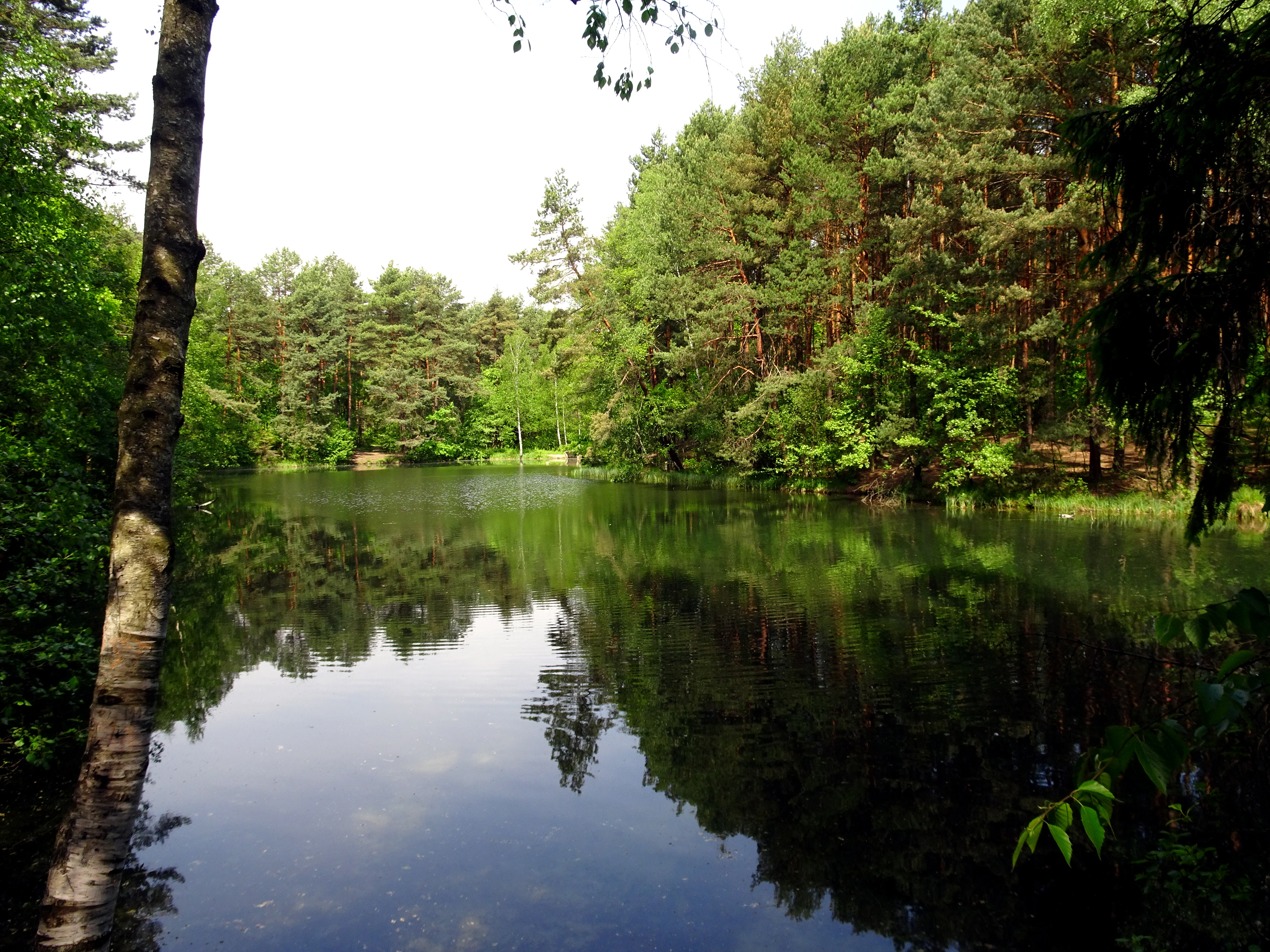
A calm, reflective pond in a forest setting with green trees and a visible birch tree in the foreground.
A serene pond within the Dolina Zabnika Nature Reserve, surrounded by dense forest.

Rezerwat Przyrody Dolina Żabnika history and protected-area timeline

Protection of the Żabnik valley developed gradually before the reserve received its formal legal designation. In 1991, the area was placed under legal protection at the request of the then president of Jaworzno, marking the first recognition of the valley's ecological value. Later, an ecological use designation was applied to the area, providing an additional layer of administrative protection before full reserve status was granted.

The decisive moment came in 1996, when the regional governor of Katowice formally established Dolina Żabnika as a partial nature reserve. The founding act formally defined both the core reserve area and a surrounding buffer zone, anchoring long-term management and protection of the valley. Since its establishment, the reserve has been managed under active conservation measures, reflecting the need for ongoing intervention to maintain its sensitive peatland and aquatic habitats.

Rezerwat Przyrody Dolina Żabnika landscape and geographic character

The landscape of Dolina Żabnika is shaped almost entirely by the Żabnik stream and its small valley. The protected area occupies a narrow, low-lying corridor of wet ground set within the broader upland terrain of the Pagóry Jaworznickie. The valley floor is dominated by open water, marshy flats, and peat-forming vegetation, while the adjacent slopes rise gently into forest.

These slopes are covered by pine-dominated and mixed forests that close in on the valley like a green frame. The contrast between the open, waterlogged core of the reserve and the darker, drier woodland around it gives the valley a clear visual identity. Because the entire catchment of the small stream is included within the reserve and its buffer zone, the landscape retains a coherent natural form, with minimal fragmentation.

The terrain itself is modest in elevation but varied at a fine scale, with small ridges, damp flats, pools, and boggy margins created by the interaction of water movement and peat accumulation. This results in a landscape that, while not dramatic, is visually distinctive and ecologically complex.
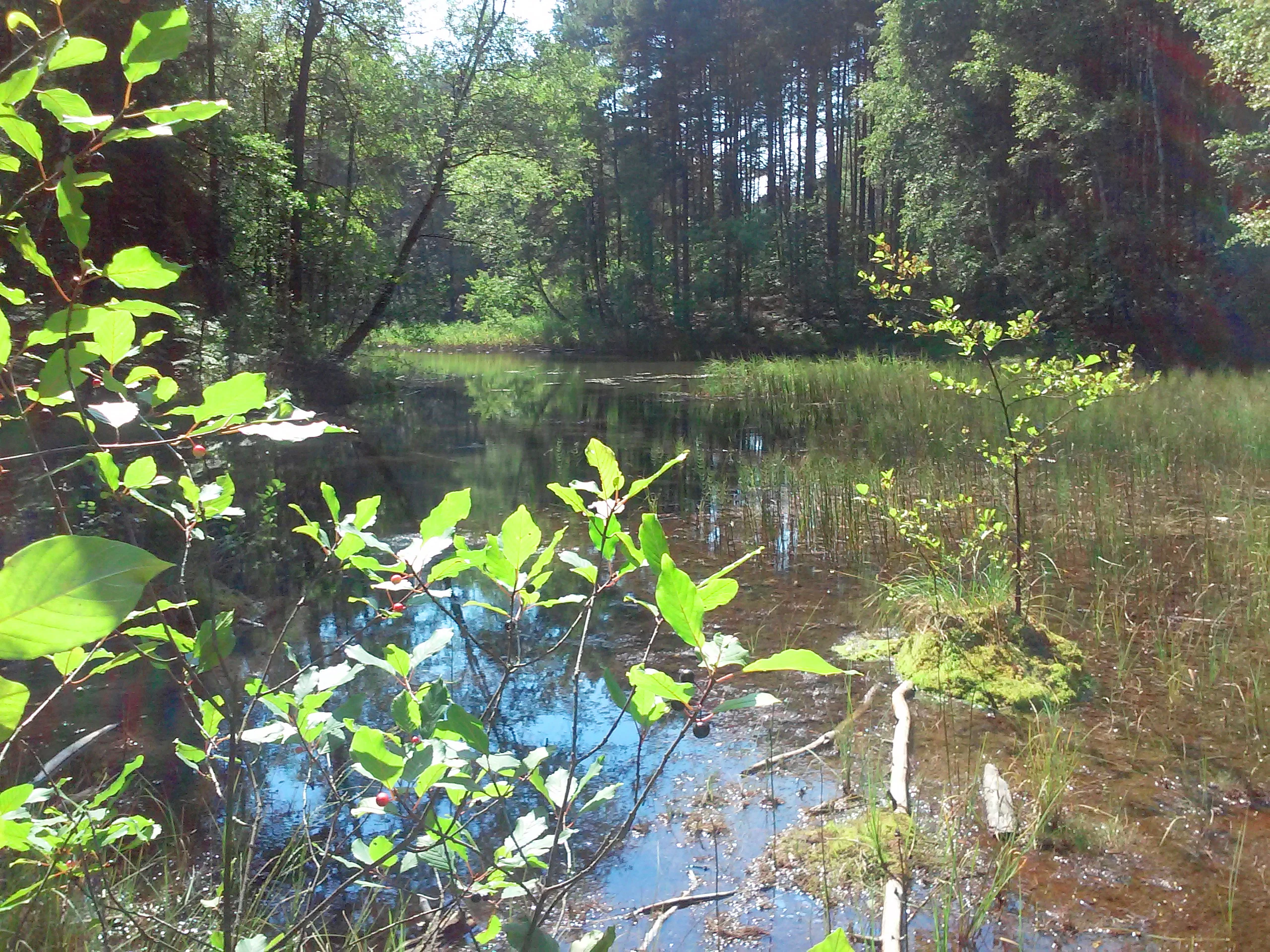
A calm, shallow body of water reflecting trees in a forest, with aquatic plants and tall trees in the background.
A peaceful view of the wetland environment in Rezerwat przyrody Dolina Żabnika.

Rezerwat Przyrody Dolina Żabnika ecosystems, habitats, and plant life

The ecological character of Dolina Żabnika is built around water and peat. The reserve protects aquatic biocenoses along the Żabnik stream together with low peat bogs and transitional mires that have developed along the valley floor. These wet habitats support a layered mosaic of plant communities, from open-water and floating vegetation through reed, sedge, and moss-rich bog surfaces.

Surrounding the wetland core is a band of pine and mixed forest that provides both a habitat contrast and ecological buffering. The forest cover includes pine-dominated stands as well as mixed communities that contribute to habitat diversity along the valley margins. Together, these habitats form a tightly connected ecological gradient that allows moisture-loving, bog, forest, and even some mountain-associated species to coexist within a single small reserve.

Surveys of the reserve have documented hundreds of vascular plant species alongside a substantial moss and liverwort flora, with significant numbers of legally protected and regionally threatened plants. This unusually rich botanical record underscores the importance of the valley as a refuge for wetland and peatland species in a region where such habitats have become increasingly rare.
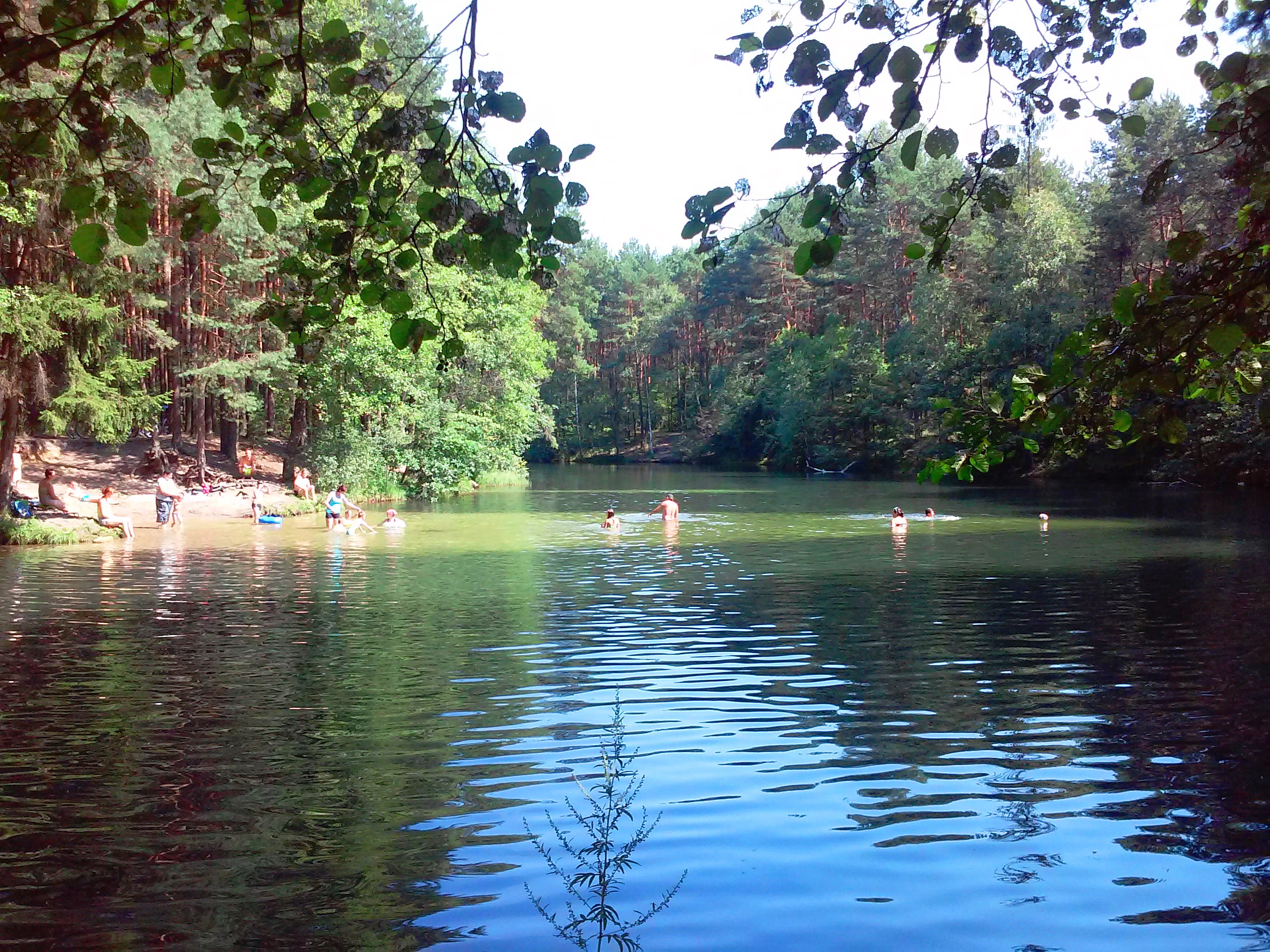
A calm, forest-lined pond with people swimming and sitting on a sandy bank under overhanging tree branches.
A scenic view of a water body within the Dolina Żabnika nature reserve, with people relaxing along the shoreline.

Rezerwat Przyrody Dolina Żabnika wildlife and species highlights

The fauna of Dolina Żabnika mirrors the diversity of its habitats. The stream and its associated wetlands support a distinctive freshwater assemblage that includes protected fish species such as the European bullhead and the stream spirlin, both of which depend on clean, well-oxygenated water. Aquatic invertebrates are also well represented, including larvae of caddisflies and stoneflies, which are indicators of good water quality.

Around the wetlands and forests, the broader fauna is rich for such a small area. Surveys have recorded roughly one hundred species in total, with a substantial share legally protected. The combination of aquatic, marshland, peatland, and forest habitats within a single small reserve means that amphibians, invertebrates, and small mammals associated with wet environments all find refuge here alongside species more typical of the surrounding pine and mixed forest.

Although the reserve is better known for its flora than for charismatic large mammals, its ecological value lies precisely in this concentration of small-scale but sensitive fauna, especially the stream-dwelling species that rely on intact valley conditions.

Rezerwat Przyrody Dolina Żabnika conservation status and protection priorities

Conservation is the central purpose of Dolina Żabnika. The reserve was established specifically to preserve, for scientific, educational, and landscape reasons, the aquatic biocenoses, low peat bogs, and transitional mires of the Żabnik valley, together with the populations of rare and protected species they support. The designation of both a core area and a buffer zone strengthens this protection by managing land use around the reserve as well as within it.

The reserve is managed through active conservation, which means that targeted interventions are used to maintain or restore the ecological conditions of the wetland and peatland habitats. This is important because peat bogs, transitional mires, and small lowland streams are among the most threatened habitat types in Poland, especially in heavily industrialized and urbanized regions such as the Silesian Voivodeship.

In a regional context, Dolina Żabnika is considered uniquely valuable for its size. The fact that so many protected and threatened species, both plant and animal, are concentrated in such a small area gives the reserve an outsized importance for biodiversity conservation in Upper Silesia, making it a reference site for the protection of small stream valleys and their associated wetland complexes.

Top sights and standout views in Rezerwat Przyrody Dolina Żabnika

The reserve's greatest highlight is the way an entire small stream valley has been preserved as a single ecological unit, allowing aquatic, peatland, marsh, and forest communities to function together rather than as isolated fragments.

Equally notable is the botanical richness: hundreds of vascular plant species, a large bryophyte flora, and a remarkable number of legally protected and threatened plants packed into under fifty hectares. Combined with protected freshwater fauna such as the European bullhead and the stream spirlin, the reserve stands out as a small but exceptionally rich natural refuge in the Silesian region.

Best time to visit Rezerwat Przyrody Dolina Żabnika

Because the reserve's character is shaped by water levels, peat vegetation, and seasonal changes in forest cover, visits are most rewarding when wetland habitats are active and visible. Late spring through early summer is generally the best period, when aquatic and bog vegetation is fully developed and the surrounding pine and mixed forest is bright and accessible.

Late summer and early autumn can also be appealing, when peatland plants and forest edges take on warm tones and streams typically run lower, making wetland margins easier to observe. Winter visits are less about active wildlife and more about appreciating the quiet, undisturbed structure of the valley and its frozen or low-water stream channel, though ice and wet ground limit easy walking.

Monthly climate preview

Long-term representative monthly averages and temperature spans for Rezerwat przyrody Dolina Żabnika

Rezerwat przyrody Dolina Żabnika Climate Normals, Annual Temperature, and Precipitation Rhythm

Rezerwat przyrody Dolina Żabnika exhibits a measured annual temperature and precipitation rhythm spanning long-term averages from -3.52 °C to 19.18 °C. Examining the complete monthly climate profile reveals precise variations in temperature extremes and daily precipitation totals across the representative coordinate.
Annual mean8 °C
-4 °C19 °C
Jan-4°
Feb-2°
Mar
Apr
May13°
Jun17°
Jul19°
Aug19°
Sep14°
Oct
Nov
Dec-2°
Warmest month
July

19.2 °C

Coolest month
January

-3.5 °C

Wettest month
July

3.5 mm/day

Driest month
December

1.5 mm/day

Park location guide

Geography guide, regional context, and park location map for Rezerwat Przyrody Dolina Żabnika

Rezerwat Przyrody Dolina Żabnika park geography, regions, and map view in Poland

Understand where Rezerwat Przyrody Dolina Żabnika sits in Poland through a broader geographic reading of the surrounding landscape, nearby location context, and its mapped position within the national park landscape.

How Rezerwat Przyrody Dolina Żabnika fits into Poland

Poland, officially the Republic of Poland, is a Central European country spanning from the Baltic Sea in the north to the Carpathian Mountains in the south. It borders Germany, Czech Republic, Slovakia, Ukraine, Belarus, Lithuania, and Kaliningrad Oblast. The country has a temperate climate, diverse landscapes, and is known for its rich history, cultural heritage, and strong economic position within the EU.

Wider geography shaping Rezerwat Przyrody Dolina Żabnika in Poland

Poland occupies 312,696 km2 in Central Europe, extending from the Baltic Sea coast in the north to the Sudetes and Carpathian Mountains in the south. It borders Germany to the west, Czech Republic and Slovakia to the south, Ukraine and Belarus to the east, and Lithuania and Kaliningrad Oblast to the northeast. The landscape includes lowland plains, uplands, and mountain ranges.

Map view of Rezerwat Przyrody Dolina Żabnika

Use this park location map to pinpoint Rezerwat Przyrody Dolina Żabnika in Poland, understand its exact geographic position, and read its mapped placement within the surrounding landscape more clearly.

Pigeon | © OpenStreetMap contributors

Visual reference for wetland habitats, stream valleys, and protected forest terrain

Rezerwat przyrody Dolina Żabnika Photos and Landscape Scenery

Visual documentation captures the unique stream valley, waterlogged peat bogs, and surrounding pine forests of Rezerwat przyrody Dolina Żabnika. Photographic records provide clear insight into the complex terrain and protected habitats defining this southern Polish reserve.

A calm, reflective pond in a forest setting with green trees and a visible birch tree in the foreground.

A small pond surrounded by dense green forest and marshy vegetation in a nature reserve.

A calm, shallow body of water reflecting trees in a forest, with aquatic plants and tall trees in the background.

A calm, forest-lined pond with people swimming and sitting on a sandy bank under overhanging tree branches.

Park atlas

Compare nearby protected areas and connected wetland habitats across the surrounding Silesian region

Explore Other Parks Near Rezerwat przyrody Dolina Żabnika and Regional Protected Landscapes

Discover protected areas near Rezerwat przyrody Dolina Żabnika to compare regional stream valleys and wetland ecosystems. Examining adjacent forest reserves provides broader context for understanding local conservation patterns and mapped terrain.
Protected areaSilesian Voivodeship
About 7.6 km away#1 closest

North

Łąki w Sławkowie Protected Area: Silesian Voivodeship Landscape and Map Analysis

Mapping rare fen and meadow habitats in southern Poland

Łąki w Sławkowie is a crucial protected habitat area situated west of Sławków. Its landscape consists of four connected enclaves characterized by wet meadow communities and calcareous fens. This data-driven overview highlights the site's hydrological and ecological significance within the broader Silesian Voivodeship and Poland's Natura 2000 network.

Area
0.51 km²
Relief
Lowland
Scope
Terrestrial
Water
Minor water
Watercolor painting depicting a soft-focus landscape with light sandy ground in the foreground, a line of green trees in the midground, and layered rolling hills in the background.
Protected areaMałopolskie
About 13 km away#2 closest

Northeast

Pustynia Błędowska: Protected Inland Sand Dunes and Geographic Map Context in Poland

An expansive shifting sand landscape within the Małopolskie region

Pustynia Błędowska stands as a unique protected site in Poland, defined by its extensive quartz sand sheets and inland dune formations. This landscape offers a compelling look at the intersection of anthropogenic history and ecological restoration, supporting rare sand-dwelling flora and invertebrates within a specialized grassland habitat.

Area
33 km²
Established
2004
Relief
Upland
Climate
Temperate
Watercolor painting of a pastoral landscape featuring soft, rolling hills, a line of trees, and muted earth tones, presented as a wide, horizontal strip.
Nature reserveLesser Poland Voivodeship
About 18 km away#3 closest

East

Dolina Eliaszówki Nature Reserve: Protected Karst Valley and Forest Geography in Lesser Poland

A study of limestone outcrops and mature forest habitats in southern Poland

Dolina Eliaszówki Nature Reserve encompasses a deeply incised limestone valley characterized by diverse forest communities and complex karst geomorphology. The reserve protects an integrated network of rock outcrops, caves, and springs, framing historical monastic landmarks within a continuous protected forest corridor. It offers an essential view into the layered natural and cultural history of the Kraków-Częstochowa Upland.

Area
1.096 km²
Established
1989
Relief
Upland
Climate
Temperate
Nature reserveSilesian Voivodeship
About 20 km away#4 closest

North

Ostoja Środkowojurajska Nature Reserve: Protected Area Geography and Habitat Mapping

Regional karst terrain and protected beech forest mosaic

Analyze the geographic structure of Ostoja Środkowojurajska, a vital Natura 2000 site in the Silesian Voivodeship. This protected area features a unique concentration of inland dunes, rocky limestone outcrops, and multiple forest types. Explore the site to understand its role in regional conservation and its varied, karst-influenced physical geography.

Area
57.676 km²
Established
2009
Relief
Upland
Climate
Temperate
Watercolor painting of a valley landscape with rolling hills, limestone rock formations on the right, and soft green vegetation.
Nature reserveLesser Poland Voivodeship
About 21 km away#5 closest

East

Rezerwat przyrody Dolina Racławki: Protected Limestone Valley and Karst Geography

Explore the forest mosaic and geological cliff features in Lesser Poland

The Rezerwat przyrody Dolina Racławki landscape reserve is a significant protected area in the Olkuska Upland. Spanning a long limestone valley, the reserve features a network of caves, rock shelters, and steep cliffs built from Carboniferous and Jurassic bedrock. Its combination of layered forest communities and protected orchid populations marks it as a vital site for understanding the natural heritage and regional geography of southern Poland.

Area
4.739 km²
Established
1962
Relief
Upland
Climate
Temperate
Protected landscapeLesser Poland Voivodeship
About 23 km away#6 closest

Southeast

Tenczyński Park Krajobrazowy: Protected Landscape and Karst Geography in Lesser Poland

Mapped limestone ridges and forest corridors near Kraków

Discover Tenczyński Park Krajobrazowy, a protected landscape park located in Lesser Poland Voivodeship. This geographic study covers the Garb Tenczyński ridge, where karst limestone formations, small caves, and volcanic outcrops shape a diverse terrain spanning from marshy lowlands to upland forest ridges.

Area
136.581 km²
Established
1981
Relief
Upland
Climate
Temperate
A soft watercolor painting of a winding stream flowing through a green valley with light trees, under a pale pink and yellow sky.
Nature reservePoland
About 23 km away#7 closest

Southeast

Rezerwat przyrody Dolina Potoku Rudno: Nature Reserve and Protected Landscape Atlas

Geographic map and protected forest terrain in Lesser Poland

Situated in the Rudno Stream valley, this nature reserve offers a detailed look at preserved alder floodplain ecosystems and rocky gorge formations. The area provides a critical protected woodland link within the Kraków-Częstochowa Upland. Use the atlas data to examine the reserve boundaries, geological exposures, and regional landscape connections in Poland.

Area
0.959 km²
Established
2001
Relief
Upland
Climate
Temperate
Watercolor painting of a rolling landscape featuring a line of evergreen trees and soft hills under a light, warm sky.
Nature reserveLesser Poland Voivodeship
About 24 km away#8 closest

East

Dolina Szklarki Nature Reserve: Atlas Map and Protected Landscape Geography

Exploring forest communities and limestone rock formations in Lesser Poland.

Analyze the protected geography of Dolina Szklarki Nature Reserve, a key nature reserve in the Kraków-Częstochowa Upland. The area features a dense concentration of limestone cliffs, distinct forest ecosystems, and karst valley terrain within Lesser Poland Voivodeship.

Area
0.467 km²
Established
1989
Relief
Upland
Climate
Temperate

Common questions about visiting, size, designation, and location context for Rezerwat Przyrody Dolina Żabnika

Rezerwat Przyrody Dolina Żabnika FAQs for park facts, access, geography, and protected area context

Find quick answers about Rezerwat Przyrody Dolina Żabnika, including protected-area facts, park geography, trail and visitor context, and how the park fits into its surrounding country and regional landscape.
MoriAtlas Explorer

Continue Your Protected Areas Search Across the Global Atlas

Deepen your exploration by continuing the structured search for national parks and protected areas worldwide. Utilize the comprehensive filtering capabilities to compare different conservation landscapes and refine your understanding of global park geography. Discover more about the distribution and characteristics of protected natural areas.

Global natural geography