
Mori Atlas logo
Nature reserveDönche

A historic mosaic of cultural grasslands, woodland pastures, and mapped aquatic habitats

Dönche Nature Reserve: Investigating the Protected Landscapes and Urban Geography of Kassel

(Naturschutzgebiet Dönche)

The Dönche nature reserve in Kassel represents a unique intersection of urban geography and preserved natural heritage. Spanning roughly 170 hectares, this protected area features a distinctive landscape mosaic of reed beds, tall herb communities, and stream-side ash woods. Its terrain reflects centuries of human activity, now managed as an ecological site for regional habitat conservation and outdoor education.

inner-city nature reserveurban nature reservegrasslandpondsreed bedsbeech wood pasture
A digital illustration showing a lush valley framed by mountains, trees, and two cascading waterfalls.

Dönche

Nature reserve

Park overview

Structured park overview, official facts, and landscape profile for Dönche

Dönche park facts, protected area profile, and essential visitor context

Review the core facts for Dönche, including designation, size, terrain, visitor scale, habitats, and operating context in one park-focused overview.

About Dönche

Dönche occupies a distinctive position in German nature conservation as a sizable protected landscape held within the boundaries of a major city. Located in the southwest of Kassel in northern Hesse, it is legally designated as a Naturschutzgebiet under German nature protection law and simultaneously forms part of a European Habitats Directive (FFH) area, giving it recognition at both regional and EU levels.

The reserve's ecological character is built around a mixture of semi-open and open habitats. Pools, reed beds and tall herb communities form a culturally shaped grassland landscape, while stream corridors along the Dönchebach and Krebsbach support alder and ash woods, and a beech wood pasture adds a forest component found relatively rarely in the region. Where soils are poorer, fragments of dry European heath survive. Grazing by domestic sheep and hardy, extensively managed cattle breeds is used to keep these open habitats from succeeding into closed woodland.

Beyond conservation, Dönche operates as a close-to-nature recreational area for Kassel residents. Visitors move through it on a marked network of circular trails rather than on roads, and a 2019 redesign of the route system established three themed loops of differing lengths through woodland, transitional landscape and open vista. Its proximity to the documenta urbana housing development also embeds the reserve directly into the everyday life of the surrounding neighborhoods.

Equally important is the area's role as an outdoor classroom. A free-air laboratory founded in 1981 within the beech wood pasture supports biology teaching in Kassel schools and the practical training of biology teacher candidates at the University of Kassel, turning Dönche into both an ecological and an educational landmark within the city.

Quick facts and research context for Dönche

Dönche is a designated nature reserve located in the southwest of Kassel, in the northern Hessian region of Germany, classified as an ortsbezirksfreies Gebiet (a district-free urban area). Its protected core covers approximately 170 hectares and sits within a larger Habitats Directive (FFH) zone of around 206 hectares.

The reserve is surrounded by the Kassel districts of Süsterfeld-Helleböhn, Niederzwehren, Oberzwehren, Nordshausen and Brasselsberg, and is crossed by the Dönchebach and Krebsbach streams. It is one of the largest inner-city nature reserves in Germany and is also adjacent to the documenta urbana housing development.

Protection and recognition

Documented conservation designations and management scope for Dönche

Dönche Protection Status and Natura 2000 International Recognition Records

Examine the verified protection status and Natura 2000 international recognition sources documented for Dönche. Review structured conservation records and official designation entries associated with this protected natural area.
Park context

Deeper park guide and search-rich context for Dönche

Dönche history, landscape, wildlife, and travel context

Explore Dönche through its history, landscape character, ecosystems, wildlife, conservation priorities, cultural context, and seasonal travel timing in a structured park guide built for atlas discovery and search intent.

Why Dönche stands out

Dönche is best known for being one of the largest inner-city nature reserves in Germany, preserving a mosaic of open grassland, ponds, reed beds and beech wood pasture within the urban fabric of Kassel. The area is also notable for its cultural-historical land-use history, including former military training ground use, and for the educational field laboratory established in 1981 in the beech wood pasture, used by Kassel schools and the University of Kassel biology teacher training program.
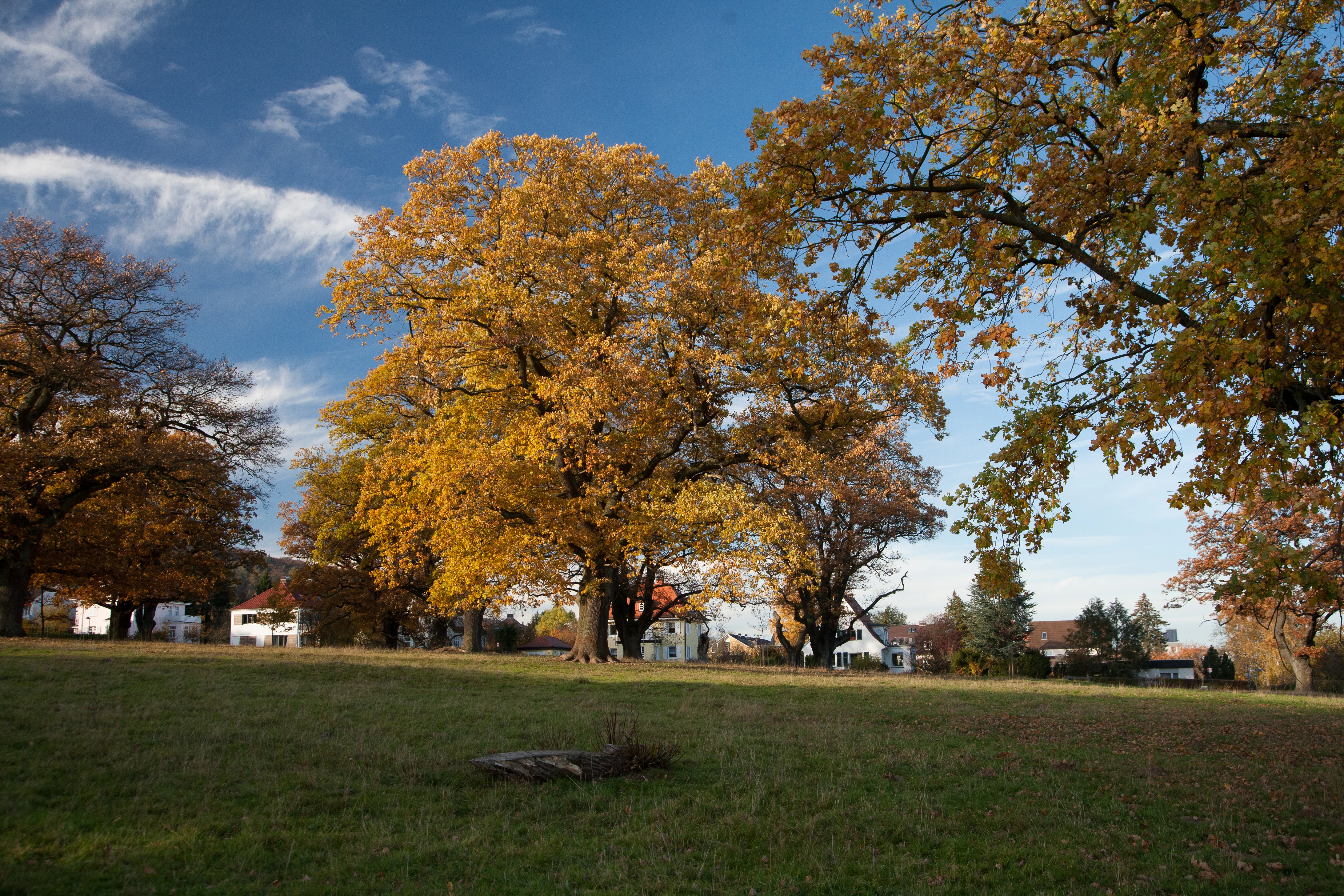
A meadow with large, mature trees featuring vibrant yellow and gold autumn leaves, with houses visible in the background under a blue sky.
Autumn foliage in the Dönche nature reserve in Kassel.

Dönche history and protected-area timeline

Dönche's written record begins on 8 June 1368 with a reference to 'Tonche,' relating to the lease and enclosure of five acres of land. Over the following centuries, the eastern and western parts of the area followed different trajectories: the eastern side was historically used as communal grazing because of poorer soils, while the western side was cultivated under a crop-rotation system that continued into the modern era.

A separation of land parcels in 1881 reorganized former commons into private plots, enabling more intensive agricultural use centered on grain and root crops. From 1870 onward, small sections were also used as a military training ground, a role that expanded significantly in 1936 when the entire Dönche was withdrawn from agriculture for troop exercises. Artillery bombardment left behind the small, round pools that are still visible in the landscape today, and the area was later used by Belgian forces stationed in Kassel after the Second World War, including for demolition training, leaving a prominent U-shaped tank ramp.

During the Nazi era, executions carried out by firing squads from the nearby Lüttich barracks took place on Dönche's territory, a use that continued with the execution of military deserters during the Second World War. In 1976 the area was first designated as a landscape protection area (Landschaftsschutzgebiet), although about 12 hectares were later released for the documenta urbana building project in 1980. In 1983 a core of roughly 35 hectares received nature reserve status, which was extended to approximately 173 hectares in 1995, and the absence of mineral nitrogen fertilization since that transition continues to shape the area's nutrient-poor soils.

In 1987 the Dönche became part of Kassel's renowned documenta art exhibition series when 'Die Fahrt nach Tahiti' was staged within the landscape as part of documenta 8.

Dönche landscape and geographic character

Dönche is a gently rolling inner-city landscape shaped by streams, ponds and historic pasture, rather than by dramatic relief. The Dönchebach and its tributary Krebsbach carve shallow valleys through the area, and along their margins, alder and ash woods form narrow green corridors.

The open ground is dotted with small, roughly circular pools that punctuate the grassland, the lasting traces of past artillery impact from the area's time as a military training ground. Together with reed beds and tall herb communities, these pools give the cultural-historical grassland landscape its characteristic rhythmic structure. To the northwest lies an oak-associated woodland area known locally as 'Unter den Eichen,' while the beech wood pasture introduces a more open, grove-like woodland character elsewhere in the reserve.

Open vistas across the landscape are a defining scenic feature, with the U-shaped tank ramp from the military era still visible as a prominent landmark on the terrain and offered as a viewpoint along the longer 'Weitsicht' trail. The result is a landscape that reads as a mosaic of meadow, pool, grove and woodland edge, framed on all sides by Kassel's residential districts.

Dönche ecosystems, habitats, and plant life

Ecologically, Dönche is defined by a deliberately maintained mix of open and semi-open habitats that depend on continued low-intensity land use. Culturally shaped grassland, dominated historically by traditional mowing and grazing practices, forms the ecological backbone of the reserve, interspersed with ponds, reed beds and tall herb communities.

The wetter zones along the Dönchebach and Krebsbach carry alder and ash forests, while dry areas support occasional patches of European heath, an increasingly rare habitat type in the region. The beech wood pasture represents a traditional agroforestry form in which scattered mature beeches stand over grazed ground, combining woodland and grassland characteristics in a single habitat. Because the reserve has not received mineral nitrogen fertilization since its transition to nature protection status, the soils remain nutrient-poor, favoring specialized plant communities adapted to low-fertility conditions.

The open character of the landscape is actively maintained through grazing by domestic sheep and extensively managed cattle breeds, a measure designed to prevent the open habitats from succeeding into closed woodland and to preserve the mosaic structure that supports the area's biodiversity.

Dönche wildlife and species highlights

The animal life of Dönche reflects the mix of grassland, woodland edge and wetland habitats that the reserve protects. Mammals typically associated with the area include European hares, wild rabbits, roe deer and red foxes, while the birdlife includes common buzzards hunting over the open terrain.

Ground-nesting bird species are particularly notable components of the reserve's fauna and are a focus of conservation concern, given the pressures from visiting dogs and free-roaming cats. Dönche's invertebrates, including its insect populations, are also recognized as an important ecological asset, although they are subject to pressure from invasive species within the broader landscape.

Dönche conservation status and protection priorities

Dönche is recognized as a nature protection area in its own right and also forms part of the European Natura 2000 network through its inclusion in an FFH (Fauna-Flora-Habitat) area, giving it conservation value at regional and EU levels. This dual status reflects both the botanical interest of its grassland, heath and woodland habitats and its role in maintaining habitat connectivity within the urban matrix of Kassel.

A central conservation strategy in the area is the use of grazing with domestic sheep and extensively managed cattle breeds to maintain the open landscape character. The reserve is also covered by a strict trail obligation (Wegegebot), meaning visitors must keep to marked paths in order to limit disturbance to wildlife and damage to vegetation.

Despite its protection, Dönche faces a number of ongoing pressures. Visitor behavior, including off-trail walking, cycling, grilling and littering, is identified as a key source of disturbance, with the removal of waste bins by Hessen-Forst to prevent illegal dumping having shifted the problem toward scattered litter in the field. Free-roaming dogs and cats threaten ground-nesting birds, and dog waste on grazed pastures can affect both sheep health and the nutrient balance of soils adapted to nutrient-poor conditions. Surrounding agriculture and traffic add chemical inputs from outside the reserve, and invasive species such as the raccoon are noted as an emerging threat to local bird and insect populations.

Dönche cultural meaning and human context

Dönche belongs to the urban and cultural landscape of Kassel, a city internationally associated with the documenta contemporary art exhibition. The reserve hosted an artwork in 1987 when 'Die Fahrt nach Tahiti' was staged as part of documenta 8, linking Dönche directly to one of Germany's most important contemporary art events.

It also sits immediately next to documenta urbana, the residential development that incorporates documenta-themed architecture and urban planning concepts, placing the reserve in direct dialogue with a major cultural-urban project of the city. The area's grazed beech wood pasture and free-air laboratory connect it to a longer German tradition of using managed cultural landscapes for outdoor education, in this case linking Kassel schools with the biology teacher training program of the University of Kassel.

Top sights and standout views in Dönche

Dönche combines unusually large-scale protected habitat with the direct urbanization of Kassel around it, offering a rare example of an inner-city nature reserve in Germany. Its identity rests on a mosaic of ponds, reed beds, tall herb communities, stream-side alder and ash woods, and a beech wood pasture, supported by traditional grazing management.

The 1981 free-air laboratory in the beech wood pasture gives Dönche a distinctive educational role, while the 2019 trail redesign with three themed circular loops makes the reserve unusually accessible for visitors interested in both nature and walking. Its inclusion in the FFH network and its layered history, from medieval common land through military use to contemporary art and conservation, give it a layered identity that goes well beyond a typical urban park.

Best time to visit Dönche

Because Dönche's attraction lies in its open grassland, ponds and woodland edges rather than in any seasonal spectacle, the reserve offers interest throughout much of the year. Late spring and summer are the most active period for visiting pollinators, tall herb communities and ground-nesting bird activity, while the reeds and ponds are at their most visually expressive in the warmer months when water levels support reed beds and tall herb growth.

In autumn the open landscapes and beech wood pasture take on a warmer color character, while winter offers calmer conditions for walking the trail network and observing winter activity of resident wildlife such as roe deer and foxes. Visitors should note that the reserve is subject to a strict trail-use obligation throughout the year, regardless of season.

Monthly climate preview

Long term temperature and precipitation records across twelve recorded intervals

Dönche Climate Normals and Measured Monthly Temperature Ranges

Representative coordinates near Kassel record monthly mean temperatures ranging from sub-zero winter minimums to warm summer maximums alongside steady precipitation. Examining the complete twelve month climatology profile reveals detailed thermal transitions and moisture distribution across Dönche.
Annual mean8 °C
-1 °C18 °C
Jan-1°
Feb
Mar
Apr
May12°
Jun16°
Jul18°
Aug18°
Sep14°
Oct
Nov
Dec
Warmest month
July

18 °C

Coolest month
January

-0.6 °C

Wettest month
July

2.5 mm/day

Driest month
April

1.5 mm/day

Park location guide

Geography guide, regional context, and park location map for Dönche

Dönche park geography, regions, and map view in Germany

Understand where Dönche sits in Germany through a broader geographic reading of the surrounding landscape, nearby location context, and its mapped position within the national park landscape.

How Dönche fits into Germany

Germany is a federal republic in Western and Central Europe with a population of over 83 million across sixteen constituent states. It is Europe's largest economy by nominal GDP and a major global exporter and importer. The capital is Berlin, and the country borders Denmark, Poland, Czech Republic, Austria, Switzerland, France, Luxembourg, Belgium, and the Netherlands.

Wider geography shaping Dönche in Germany

Germany is located in Western and Central Europe, spanning 357,022 km². It borders Denmark to the north, Poland and the Czech Republic to the east, Austria and Switzerland to the south, and France, Luxembourg, Belgium, and the Netherlands to the west. The country has coastlines on the Baltic Sea and North Sea to the north, with the Alps located in the southern region.

Map view of Dönche

Use this park location map to pinpoint Dönche in Germany, understand its exact geographic position, and read its mapped placement within the surrounding landscape more clearly.

Pigeon | © OpenStreetMap contributors

Location context for Dönche

Kassel

Explore photographic records of grassland, ponds, and urban nature habitats.

Visualizing Dönche Photos, Landscapes, and Protected Area Scenery

Visual documentation captures the diverse terrain, stream valleys, and grassland mosaics that define the Dönche protected landscape. Examining these field photographs reveals the ecological character and varied habitats preserved within this urban nature reserve.

A meadow with large, mature trees featuring vibrant yellow and gold autumn leaves, with houses visible in the background under a blue sky.

A dirt path leading into a green open field with scattered trees and distant hills under a cloudy sky.

Park atlas

Compare regional green spaces and connected conservation areas across northern Hesse.

Exploring Parks Near Dönche and Surrounding Protected Landscapes in Northern Hesse

Browse other parks and protected areas located near Dönche to compare regional geography and habitat types. Expanding the search helps reveal connected conservation landscapes and similar green spaces across the surrounding region.
Watercolor painting of a rolling forested landscape with distant hills under a soft light.
Nature reserveHesse
About 6.4 km away#1 closest

Northwest

Erlebach bei Ehlen Nature Reserve: Protected Terrain and Brook Valley Geography in Hesse

Mapped beech forest mosaic and riparian habitat corridors

Located in the Hoher Habichtswald, Erlebach bei Ehlen preserves a distinctive transition between mature beech forest and open grassland valley. This nature reserve serves as an essential case study for understanding riparian ecology, stream-side woodland distribution, and habitat connectivity within the regional topography of Hesse, Germany.

Area
0.342 km²
Established
1996
Watercolor painting of a soft, rolling landscape with green fields, distant hills, and low foreground vegetation.
Protected areaGermany
7.1 km away#2 closest

West

Langenberger Huete bei Breitenbach: Mapped Geography and Protected Area Landscape Context

Nature reserve terrain and grassland boundaries in northern Hesse

Examine the geographic layout of Langenberger Huete bei Breitenbach, a protected dry grassland area near Schauenburg, Germany. This site preserves open meadow habitats along the forested Langenberg ridge, offering insight into traditional land use and small-scale conservation within the Habichtswald region. Access detailed boundary data and terrain information to understand its position within the surrounding agricultural and woodland zones.

Area
0.14 km²
Established
1992
Relief
Upland
Climate
Temperate
A horizontal watercolor illustration depicting a river flowing through a lush green floodplain with trees and distant hills under a soft, light-colored sky.
Nature reserveHessen
8.1 km away#3 closest

Northeast

Fuldaschleuse Wolfsanger Nature Reserve: Geography and Protected Riverine Terrain

A restored floodplain ecosystem in the Hessen region.

Fuldaschleuse Wolfsanger stands as a masterfully restored nature reserve along the River Fulda. This compact 14-hectare site features a man-made island, shallow-water zones, and softwater floodplain forests that support over 120 bird species. Its layout provides a rare example of integrated conservation within a modern urban-edge environment, demonstrating the success of deliberate floodplain engineering for biodiversity.

Area
0.14 km²
Established
1985
IUCN
IV
A horizontal watercolor painting showing a soft, hazy landscape with green hills, patches of grass, and purple-tinted distant mountains under a white sky.
Nature reserveLandkreis Kassel
8.3 km away#4 closest

North

Keischel bei Weimar: Nature Reserve Protected Area and Regional Geography

A calcareous grassland mosaic in the Landkreis Kassel district

Keischel bei Weimar preserves a 19.7-hectare landscape defined by Muschelkalk limestone bedrock and traditional agricultural practices. This nature reserve serves as a critical refuge for specialized flora and insect species, showcasing the value of integrated land management within the broader West Hessian Depression and northern Hesse regional geography.

Area
0.197 km²
Established
1992
Relief
Upland
Climate
Temperate
A horizontal watercolor painting depicting a soft, rolling landscape with green hills, conifer trees, and misty purple mountains in the background against a white backdrop.
Nature reserveLandkreis Kassel
About 9.1 km away#5 closest

Northwest

Dörnberg Nature Reserve: Geographic Map and Protected Landscape Overview in Landkreis Kassel

Analyzing the limestone slopes and volcanic terrain of the Dörnberg massif.

Explore the Dörnberg nature reserve through a geographic lens, focusing on its protected status within the Landkreis Kassel region. This area encompasses 116 hectares of steep limestone slopes, supporting a dense collection of calcareous grasslands and rare orchid species. The site is physically defined by its striking Miocene basalt outcrop, providing a clear focal point for studying regional Hessian topography and conservation-led land management.

Area
1.166 km²
Established
1978
Relief
Mountain
Climate
Temperate
A horizontal watercolor illustration depicting rolling green hills, patches of forest, and a calm river in the foreground, rendered in soft, pastel tones.
Nature reserveHesse
About 10 km away#6 closest

Northeast

Kragenhof bei Fuldatal Nature Reserve: Mapped Floodplain Landscapes in Hesse, Germany

Protected riparian ecosystems and river meander geography

Located in the state of Hesse, Kragenhof bei Fuldatal is a significant nature reserve protecting a complex mosaic of Fulda River floodplain habitats. The area features shifting currents, small wooded islands, and open grassland within a distinctive meander-driven landscape. Explore the geographic boundaries and ecological structure of this important regional waterbird refuge.

Area
0.077 km²
Established
1981
A soft watercolor illustration of a winding stream flowing through a green meadow with rolling hills in the background and a small cluster of pine trees in the foreground.
Nature reserveHessen
About 11 km away#7 closest

North

Jungfernbach und Brandteich bei Calden: Protected Forest and Stream Valley Geography

Regional nature reserve landscape located in northern Hessen

Examine the mapped boundaries and natural terrain of Jungfernbach und Brandteich bei Calden. This nature reserve offers a detailed look at lowland stream corridors, pond ecosystems, and riparian forest patches nestled within the rolling landscape of northern Hessen, reflecting the region's diverse protected land character.

Area
0.343 km²
Established
1985
Watercolor painting of a calm wetland landscape with soft green trees along the water edge under a light, misty sky.
Nature reserveHessen
13 km away#8 closest

North

Rothenberg bei Burguffeln Protected Wetland Landscape and Nature Reserve in Hessen

A specialized pond and meadow mosaic in the Hessian lowlands

Rothenberg bei Burguffeln preserves a vital wetland complex near Immenhausen, structured across three distinct sections, including the Rothenküler Teich and Tonkaule. The area represents a significant example of culturally shaped lowland geography, blending historic aquaculture with contemporary habitat management. Its protected status reflects a commitment to maintaining intricate riparian corridors and meadow ecosystems within the wider Hessian countryside.

Area
0.278 km²
Established
1983

Common questions about visiting, size, designation, and location context for Dönche

Dönche FAQs for park facts, access, geography, and protected area context

Find quick answers about Dönche, including protected-area facts, park geography, trail and visitor context, and how the park fits into its surrounding country and regional landscape.
MoriAtlas Explorer

Continue Your Protected Areas Search Across the Global Atlas

Deepen your exploration by continuing the structured search for national parks and protected areas worldwide. Utilize the comprehensive filtering capabilities to compare different conservation landscapes and refine your understanding of global park geography. Discover more about the distribution and characteristics of protected natural areas.

Global natural geography