
Mori Atlas logo
Protected landscapeDorm

Analyzing the narrow anticline, calcareous forest habitats, and regional geological ridge structure

Dorm Protected Landscape and Geographic Ridge in Lower Saxony, Germany: A Mapped Atlas Overview

The Dorm is a distinct hill ridge and protected landscape located within the East Brunswick hill country of Lower Saxony. Formed by complex salt tectonics, this narrow anticline features an intricate mosaic of beech and oak forests, doline pools, and unique saline vegetation. Our atlas mapping provides a detailed look at its geological profile and position within the northern Harz foreland, highlighting its role as a key protected area for local biodiversity and regional terrain study.

low hill ridgeeast brunswick hill countrybeech and oak forestdolinescalcareous woodlandsalt vegetation
Digital vector-style illustration featuring rolling hills, coniferous trees, a cascading waterfall in the distance, and small pools of water in the foreground under a pastel sky.

Dorm

Protected landscape

Park overview

Structured park overview, official facts, and landscape profile for Dorm

Dorm park facts, protected area profile, and essential visitor context

Review the core facts for Dorm, including designation, size, terrain, visitor scale, habitats, and operating context in one park-focused overview.

About Dorm

The Dorm is a modest but ecologically and geologically interesting ridge in the East Brunswick hill country of Lower Saxony, in north-central Germany. Despite reaching only about 181 meters at its highest point, the Fuchsberg, the ridge has a distinctive character derived from its geology, forest cover, and landscape protections. It lies between the well-known Elm ridge to the southwest and the Lappwald forest to the east, forming part of a continuous band of protected hill landscapes that stretches eastward from Königslutter am Elm toward Helmstedt.

In administrative terms the Dorm is situated within the municipality of Königslutter am Elm in the district of Helmstedt, with parts of its flanks sweeping into neighboring communities such as Rennau and Helmstedt itself. The area is fully embedded in two complementary frameworks: the Elm-Lappwald Nature Park, which frames the recreational and educational uses of the hills, and the Harz, Brunswick Land, and Eastphalia Geopark, which highlights the region's geological heritage. Together these designations place the Dorm within one of the more actively curated nature and landscape regions of Lower Saxony.

For visitors, the Dorm is a quiet, wooded ridge crossed by forest paths and longer hiking routes such as the regional four-forest circular trail linking the Dorm, Elm, Elz, and Lappwald. Its neighborhood of small villages, the Schunter river along its southern flank, and the proximity of the A2 motorway make it easily reachable while still offering the feeling of a continuous countryside. The Dorm is therefore primarily a destination for hikers, geologists, and nature enthusiasts rather than a mass tourism attraction.

Quick facts and research context for Dorm

The Dorm is a low ridge in the East Brunswick hill country, part of the broader northern Harz foreland landscape. It is administered largely through the municipality of Königslutter am Elm in the Helmstedt district of Lower Saxony. The ridge lies within both the Elm-Lappwald Nature Park and the Harz, Brunswick Land, and Eastphalia Geopark, giving it a dual role in regional nature conservation and geological interpretation.

Its highest point is the Fuchsberg at roughly 181 meters above sea level, marked by a transmission mast and tower. The Dorm has been a European Natura 2000 (FFH) site since 2000 and gained status as an independent landscape protection area (LSG HE 026) in 2020, covering roughly 6.89 square kilometers. It is closely associated with the adjacent elm and Lappwald landscapes, forming part of the larger protected mosaic between the Elm and the Harz foothills.

Protection and recognition

Documented terrestrial protection metrics and official Natura 2000 records for Dorm

Dorm Protection Status, Designation History, and International Recognition

Terrestrial conservation records for Dorm outline established protection milestones and official Natura 2000 designations. Documented recognition sources supply verified framework metrics for tracking the protected area footprint and administrative history.

International recognition

Protection details

Protection scope
Terrestrial
Designated year
2020
Transboundary protection
No
Park context

Deeper park guide and search-rich context for Dorm

Dorm history, landscape, wildlife, and travel context

Explore Dorm through its history, landscape character, ecosystems, wildlife, conservation priorities, cultural context, and seasonal travel timing in a structured park guide built for atlas discovery and search intent.

Why Dorm stands out

The Dorm is most known for its compact and well-exposed geological structure, a narrow anticline shaped by deep salt movement and surfaced by Triassic Buntsandstein and Muschelkalk limestones. The ridge is appreciated by geologists and archaeology enthusiasts for its dolines, gypsum outcrops, the Bockshornklippe quartzite formation, a megalithic tomb, and a dedicated geology and nature trail run by the regional open-air museum. Ecologically, the Dorm is recognized for its diverse hardwood forest mosaic, with near-natural beech and oak-hornbeam stands on calcareous and sandstone substrates. The combination of doline pools, alder-ash wet woodland, saline vegetation on former mining heaps, and calcareous tufa springs gives the ridge an unusually varied habitat profile for such a small elevation feature in northern Germany.
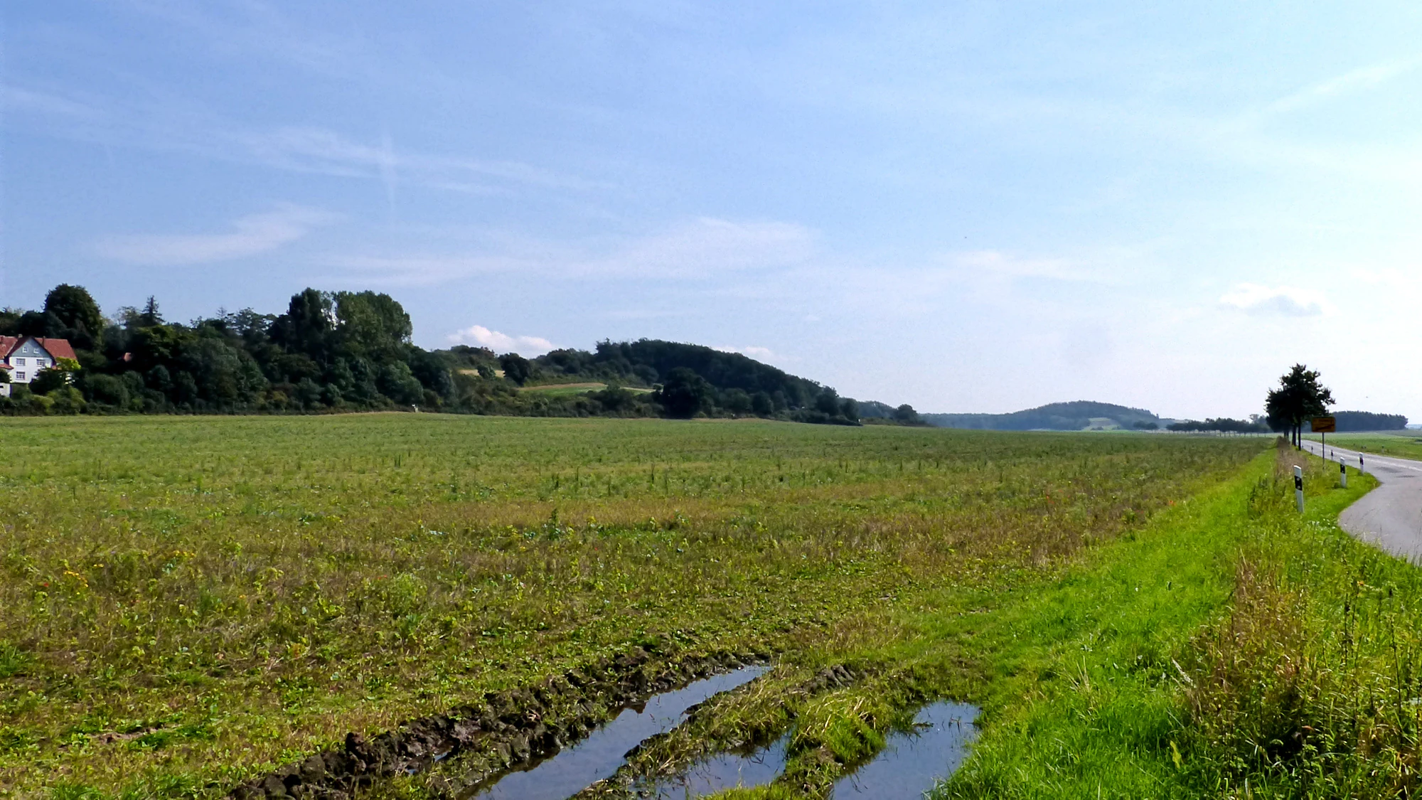
A wide, outdoor shot of a rural landscape with a large grassy field in the foreground, a paved road on the right, and a tree-covered ridge in the background under a blue sky.
A view of the Dorm ridge near Beienrode, showing agricultural fields and the foothills of the landscape area.

Dorm history and protected-area timeline

The geological history of the Dorm is closely tied to deep salt movements in the subsurface. Zechstein salts beneath the ridge have, through halokinesis, pushed the overlying strata upward to produce a narrow anticline. Today the surface layers include Buntsandstein and Muschelkalk, with remnants of gypsum from the Röt formation subroded in places to create dolines. Salt was historically mined at the Dorm; the legacy of this activity is visible in the Glauber salt heaps near Beienrode, which themselves support salt-tolerant vegetation recognized in the area's conservation profile.

Human history in the Dorm area reaches well back into prehistory. Near the southwestern edge of the ridge lies the Großsteingrab von Groß Steinum, a megalithic tomb associated with the Funnelbeaker culture, along with two further stone age burial monuments. These prehistoric structures, together with the Bockshornklippe quartzite outcrop, are focal points of the geology and nature trail set up by the Freilicht- und Erlebnismuseum Ostfalen, which begins in Groß Steinum. In modern administrative history, the Dorm was part of the larger Mittlere Schunter landscape protection area until 2020, when it was separated out as its own landscape protection area under the designation LSG HE 026, recognizing its independent ecological identity.

Dorm landscape and geographic character

Physically the Dorm is a compact, southeast-to-northwest-trending hill ridge about seven kilometers long and three kilometers wide. Its flanks descend into the surrounding lowlands on either side: to the north toward the Hasenwinkel and the Schunter valley, and to the south toward the Schunter river itself, which traces the southwestern base of the ridge. The terrain rises gently rather than dramatically, but the relative relief over the surrounding agricultural lowlands is enough to give the Dorm a clearly defined silhouette when viewed from village edges such as Beienrode.

The ridge belongs to the natural region known as the Dorm hill country (Dormhügelland), nested within the East Brunswick hill country and, more broadly, the northern Harz foreland. To its southwest lies the better-known Elm ridge, and to its southeast the Elz, with the Lappwald stretching further east. Beyond the immediate hill country the landscape steps down into the Weser-Aller flatland to the north and northwest. This transitional position between upland and plain contributes to the variety of habitats found on the Dorm, from dry woodland slopes to wetter valley bottoms near the Schunter and its tributary the Uhrau.

Dorm ecosystems, habitats, and plant life

Ecologically the Dorm is best understood as a mosaic of forest types developed on different bedrock. The rocks range from sandstone and marl through limestone to gypsum, with saline substrates in the areas affected by former salt mining. This geological diversity translates directly into vegetation diversity, supporting near-natural beech forests and oak-hornbeam woods on calcareous and sandstone sites, with alder-ash wet woodland along watercourses and dolines. The doline pools (Erdfalltümpel) formed by the subrosion of subsurface salts are especially valuable for amphibians, providing breeding habitat that is otherwise rare in the surrounding intensively used lowlands.

The conservation status of the Dorm reflects this combination of forest and small-scale wetland habitats. Since 2000, large parts of the ridge have been protected as a European Fauna-Flora-Habitat (FFH) site, and since 2020 the area has its own landscape protection designation. In many stands, however, the woodland character has been altered by the historical introduction of non-native conifers, mainly spruce and larch, and by past clear-cutting that has reduced the proportion of old trees. Restoration of more natural forest structure is now an important aspect of ongoing management in the protected area.

Dorm wildlife and species highlights

The wildlife profile of the Dorm is closely linked to its forest mosaic and small-scale wetland features. The doline pools are particularly important for amphibians, providing breeding habitat within an otherwise dry-dominated landscape of forest and arable fields. Calcareous tufa springs with stands of charophyte algae, combined with wet alder-ash woodland, support invertebrate and amphibian communities that are characteristic of nutrient-poor to mesotrophic calcareous habitats in central Europe.

The beech and oak-hornbeam forests that dominate the ridge provide habitat for typical woodland bird and mammal communities of the central German lowland hill country. Although specific species lists are not the focus of this profile, the combination of mature broadleaf forest, open dolines, and saline edge habitats supports a richer and more varied fauna than the modest elevation of the ridge would suggest. The presence of salt vegetation on the old Glauber salt heaps near Beienrode is an additional habitat feature, hosting halophilic plant communities that in turn support specialized invertebrates.

Dorm conservation status and protection priorities

The Dorm is a regionally important conservation area, recognized at both the landscape level and the European habitat level. As a landscape protection area (Landschaftsschutzgebiet, designation LSG HE 026) covering roughly 6.89 square kilometers since 2020, the ridge is protected from large-scale land-use change and fragmentation. The EMA2 motorway passes to the northeast of the ridge, but its associated junctions, at Rennau and Königslutter, are positioned so that the main forested core remains relatively undisturbed.

Overlap with the European Natura 2000 network adds a further layer of protection. The Fauna-Flora-Habitat site Dorm (FFH-Nr. 3731-331; around 6.77 square kilometers) was designated in 2000 and focuses on the conservation of hardwood forest habitats, calcareous woodland communities, and small-scale wetland features such as doline pools and tufa springs. Conservation management on the Dorm must address two long-standing issues: the legacy of non-native conifer plantations, particularly spruce and larch, and the reduced amount of old-growth and deadwood habitat caused by earlier clear-cutting. Efforts to restore more natural forest structure are therefore central to the area's ongoing conservation value.

Dorm cultural meaning and human context

Human interaction with the Dorm landscape extends far back into prehistoric times. The Großsteingrab von Groß Steinum, a megalithic tomb of the Funnelbeaker culture, stands at the southwestern edge of the ridge and is one of the more important prehistoric monuments in the region. Two further burial monuments are known nearby, and together with the Bockshornklippe and other rock exposures they form an archaeologically rich landscape that has long attracted interest from archaeologists and megalith enthusiasts.

In more recent centuries, the Dorm has been shaped by small-scale mining and rural land use. Salt extraction in the underlying Zechstein strata has left the Glauber salt heaps near Beienrode, an unusual cultural-ecological feature that is now part of the protected area's identity. The ridge itself is integrated into the cultural landscape of the East Brunswick region through long-established villages such as Groß Steinum, Beienrode, and the nearby town of Königslutter am Elm, whose histories are intertwined with the surrounding hills. The implementation of a geology and nature trail by the Freilicht- und Erlebnismuseum Ostfalen reflects a contemporary effort to connect local cultural heritage, geology, and natural history for visitors.

Top sights and standout views in Dorm

The Dorm highlights include the Fuchsberg summit with its transmission mast, the Bockshornklippe quartzite formation near Groß Steinum, and the Großsteingrab von Groß Steinum, a megalithic tomb of the Funnelbeaker culture. Other key features are the saline vegetation around the historic Glauber salt heaps near Beienrode, the doline pools important for amphibians, and the geology and nature trail run by the regional open-air museum. The continuous forest mosaic of beech and oak-hornbeam stands on calcareous and sandstone soils provides an additional, quieter highlight for those interested in woodland landscapes.

Best time to visit Dorm

The Dorm is a wooded, low-elevation ridge best experienced on foot, and its most appealing seasons are spring and early autumn. In spring, the broadleaf forests come into fresh leaf, woodland flowers appear on the calcareous slopes, and the doline pools are most active for amphibians. Early autumn brings clearer views across the ridge from its edges, stable paths, and the color change of beech and oak stands without the more crowded summer visitor pressures of larger German hill regions.

In high summer the forest interior remains cool and pleasant for walking, though the dense canopy limits long-distance views from the lower slopes. Winter can be quiet and atmospheric, but some paths may be muddy and views are partly obscured by bare but still densely branched trees. All visits benefit from the well-developed network of forest tracks, the four-forest circular route, and the geology and nature trail at Groß Steinum, which together make the Dorm a rewarding destination across most of the year for those who prefer gentle, low-relief walking terrain.

Monthly climate preview

Track monthly temperature ranges and precipitation rhythm across Dorm

Dorm Climate Normals: Long Term Temperature and Precipitation Patterns

Representative coordinates record measured monthly temperature swings from sub-zero winter lows to warm summer highs alongside steady precipitation rates throughout the year. Reviewing the complete twelve-month climate profile provides detailed historical baseline data for temperature averages and monthly precipitation totals across Dorm.
Annual mean9 °C
0 °C19 °C
Jan
Feb
Mar
Apr
May13°
Jun17°
Jul19°
Aug18°
Sep14°
Oct
Nov
Dec
Warmest month
July

18.6 °C

Coolest month
January

0.2 °C

Wettest month
July

2.6 mm/day

Driest month
April

1.4 mm/day

Park location guide

Geography guide, regional context, and park location map for Dorm

Dorm park geography, regions, and map view in Germany

Understand where Dorm sits in Germany through a broader geographic reading of the surrounding landscape, nearby location context, and its mapped position within the national park landscape.

How Dorm fits into Germany

Germany is a federal republic in Western and Central Europe with a population of over 83 million across sixteen constituent states. It is Europe's largest economy by nominal GDP and a major global exporter and importer. The capital is Berlin, and the country borders Denmark, Poland, Czech Republic, Austria, Switzerland, France, Luxembourg, Belgium, and the Netherlands.

Wider geography shaping Dorm in Germany

Germany is located in Western and Central Europe, spanning 357,022 km². It borders Denmark to the north, Poland and the Czech Republic to the east, Austria and Switzerland to the south, and France, Luxembourg, Belgium, and the Netherlands to the west. The country has coastlines on the Baltic Sea and North Sea to the north, with the Alps located in the southern region.

Map view of Dorm

Use this park location map to pinpoint Dorm in Germany, understand its exact geographic position, and read its mapped placement within the surrounding landscape more clearly.

Pigeon | © OpenStreetMap contributors

Location context for Dorm

Lower Saxony

Visual reference of ridge terrain, forest habitats, and geological formations across the protected landscape.

Dorm Photos, Landscape Scenery, and Protected Area Views

Visual documentation captures the varied terrain, hardwood forest mosaic, and geological features that define the protected landscape of Dorm. Examining these field photographs reveals the distinctive ridge silhouette, woodland habitats, and regional topography that characterize the local environment.

A wide, outdoor shot of a rural landscape with a large grassy field in the foreground, a paved road on the right, and a tree-covered ridge in the background under a blue sky.

A white information sign stands in the foreground on the left, overlooking a grassy field with large boulders, scattered trees, and a dirt path leading toward the distance.

Park atlas

Compare regional hill ridges and adjacent protected natural areas across Lower Saxony

Explore Other Parks Near Dorm and Surrounding Protected Landscapes

Browse neighboring protected areas and connected forest reserves to compare regional park geography beyond Dorm. Evaluating adjacent terrain helps place local geological formations within a broader northern Harz foreland network.
Protected landscapeLower Saxony
About 15 km away#1 closest

West

Weddeler Teich Protected Landscape: Wetland Geography and Regional Map Context

A mapped nature reserve in the Lower Saxony lowlands

Weddeler Teich is a protected landscape in Lower Saxony characterized by its shallow, nutrient-rich basin and extensive reed vegetation. This wetland reserve acts as a critical refuge for bird species, standing out as a verdant marshy pocket within the wider cultivated agricultural plains east of Braunschweig.

Area
0.2 km²
Established
1981
Relief
Lowland
Climate
Temperate
Nature reserveNiedersachsen
About 18 km away#2 closest

North

Wendschotter und Vorsfelder Drömling mit Kötherwiesen: Protected Peatlands and Floodplains

Niedersachsen lowland geography and wetland habitat mapping

Spanning over 700 hectares in Wolfsburg, this nature reserve protects a complex network of marshes, reedbeds, and alluvial meadows. This atlas-focused overview examines the reserve's historic ditch systems, river corridors, and its role as a core component of the regional Drömling ecological network.

Area
7.22 km²
Established
2020
Relief
Lowland
Climate
Temperate
Nature reserveLandkreis Helmstedt
About 19 km away#3 closest

North

Südlicher Drömling: Protected Floodplain Landscapes in Landkreis Helmstedt

Wetland nature reserve and alluvial forest geography

Südlicher Drömling represents a critical protected wetland area defined by the Aller river floodplain. The landscape provides a study in successional dynamics, featuring old-growth alluvial forests, species-rich wet meadows, and temporary open-water pools during seasonal flooding periods. It stands as an important regional anchor for migratory bird species and floodplain restoration within the broader Drömling basin.

Area
6.02 km²
Established
2018
Nature reserveLower Saxony
27 km away#4 closest

North

Vogelmoor Nature Reserve: Geographic Map and Protected Wetland Landscape in Lower Saxony

Birch bog forests, peat ponds, and rare mire habitats

Vogelmoor offers a deep look into the glacial topography of northern Germany. As a core protected area within the Gifhorn district, this site features a diverse assembly of sphagnum-rich forest, floating mats, and open heath. The reserve stands as a critical example of landscape restoration within a heavily agricultural region, providing essential refuge for wetland bird species and specialized bog vegetation.

Area
1.335 km²
Established
1974
IUCN
IV
Nature reserveLower Saxony
About 31 km away#5 closest

Northwest

Viehmoor Nature Reserve: A Detailed Atlas of Wetland and Dune Landscapes in Lower Saxony

Protected lowlands, inland dunes, and riparian habitats

Viehmoor is a distinct 302-hectare protected area in Lower Saxony defined by its glacial history and diverse habitat transitions. The site features an inland dune ridge encircling a groundwater-fed lowland mire, alongside varied aquatic environments including reed-fringed fishponds and peat-cutting pools that provide vital breeding grounds for regional bird populations.

Area
3.02 km²
Established
1979
IUCN
IV
Nature reserveSalzgitter
About 41 km away#6 closest

Southwest

Tagebau Haverlahwiese Nature Reserve: Geography and Protected Area Mapping in Salzgitter

Mapping restored post-industrial landscapes and habitat mosaics.

This protected area in Salzgitter showcases the natural recovery of former ironstone mining lands. Users can examine the spatial arrangement of the 15-hectare mining lake, extensive reedbeds, and dry calcareous grassland slopes. The site remains a vital example of landscape conservation, illustrating how engineered topography provides new niches for amphibians and salt-tolerant plant communities across the Lichtenberge ridge.

Area
2.06 km²
Established
2016
Relief
Upland
Climate
Temperate
Nature reserveLower Saxony
42 km away#7 closest

West

Wendesser Moor Nature Reserve: Mapped Wetland Geography and Protected Landscape Context in Lower Saxony

Exploring the peatland mosaic and marsh bird habitats of the Peine district

Wendesser Moor is a significant 63-hectare nature reserve in Lower Saxony, defined by its rare concentration of fen habitats, alder carr, and open peat pools. As a core component of a wider landscape protection zone, it provides essential refuge for threatened bird species. The reserve functions as a critical node in the local watershed, illustrating how small-scale protected peatlands maintain biodiversity in agricultural lowlands.

Area
0.632 km²
Established
1973
IUCN
IV
Relief
Lowland
Watercolor illustration of a mountainous landscape with forests and a winding path
National parkLower Saxony
44 km away#8 closest

South

Harz National Park: A Mapped Protected Landscape in Lower Saxony's Mountains

Explore geographic boundaries and regional terrain.

Harz National Park is a protected area defined by its unique mountain landscape and extensive forests in Lower Saxony, Germany. This MoriAtlas entry details its geographic scope, allowing for exploration of its mapped boundaries and its place within the regional geography. Understand the terrain, from its highest peaks to its alpine bogs, offering a structured view of this significant protected landscape for atlas-based discovery.

Area
247 km²
Established
2006
IUCN
II
Visitors
4M annual

Common questions about visiting, size, designation, and location context for Dorm

Dorm FAQs for park facts, access, geography, and protected area context

Find quick answers about Dorm, including protected-area facts, park geography, trail and visitor context, and how the park fits into its surrounding country and regional landscape.
MoriAtlas Explorer

Continue Your Protected Areas Search Across the Global Atlas

Deepen your exploration by continuing the structured search for national parks and protected areas worldwide. Utilize the comprehensive filtering capabilities to compare different conservation landscapes and refine your understanding of global park geography. Discover more about the distribution and characteristics of protected natural areas.

Global natural geography