Mori Atlas logo
Nature reserveDraved Skov

Explore the glacial moraine terrain and integrated bog ecosystems of this Southern Jutland nature reserve.

Draved Skov Nature Reserve: A Detailed Map of Denmark's Premier Untouched Forest Landscape

Draved Skov represents a significant reference site for natural forest development in Denmark, serving as the largest continuous stretch of untouched woodland in the country. This nature reserve, situated on the Kongensbjerg glacial hill, displays a rare soil-driven mosaic where species-rich broadleaf forests transition into saturated alder hollows and adjacent raised bogs. The area stands as an essential protected landscape for studying primeval forest dynamics and large-scale ecological rewilding in the Nordic region.

natural forestbroadleaf forestuntouched forestrewildingraised bogwetland

Draved Skov

Nature reserve

Park overview

Structured park overview, official facts, and landscape profile for Draved Skov

Draved Skov park facts, protected area profile, and essential visitor context

Review the core facts for Draved Skov, including designation, size, terrain, visitor scale, habitats, and operating context in one park-focused overview.

About Draved Skov

Draved Skov lies in the southwestern part of the Jutland peninsula, in the region historically known as Grænselandet, the borderland between Denmark and Germany. The forest occupies part of an ancient glacial moraine hill called Kongensbjerg bakkeø, a remnant of the Weichselian glaciation, and extends outward onto former outwash plains of much poorer sandy soil. This juxtaposition of substrate types within a compact area is the geographic foundation of the entire woodland.

Because both the moraine clay and the surrounding sand plain are saturated much of the year, the soils support a forest community rich in moisture-loving species. The dominant trees are pedunculate oak, small-leaved linden, and common alder, accompanied by ash, hazel, holly, rowan, birch, aspen, hawthorn, wild apple, and alder buckthorn. On the drier clay soils the forest floor is mull-like and rich, while on the sandy outwash it shifts to mor-type, and in the hollows the substrate becomes deeply humus-rich and waterlogged. The result is a visibly patchy woodland in which canopy composition, understory, and even deadwood patterns shift over short distances.

Draved Skov's importance extends well beyond its local setting. Because it was historically hemmed in by bog, timber extraction was difficult and rarely profitable, and the forest avoided the heavy exploitation that reshaped most other Danish woodlands. The Danish state recognized its scientific and conservation value in stages: ten hectares were protected in 1948 for research, an additional twenty hectares of old forest and fifty hectares of wooded bog were added in 1963, and finally in 1994 the entire forest, roughly 250 hectares, was taken out of commercial management to become the largest single block of untouched forest in Denmark. Spruce plantations have since been removed and drainage ditches filled or dammed, reinforcing the forest's hydrology and natural processes.

In 2022 the area was designated as part of the new Danish national nature park system, bringing Draved Skov and the adjacent Kongens Mose together into one larger national nature park of around 564 hectares. The combined site is also designated as Natura 2000 area number 99, and is recognized both as a habitat area (H88) and a bird protection area (F61). Today Draved Skov functions simultaneously as a research laboratory for natural forest dynamics, a conservation flagship for lowland broadleaf forest protection, and a public landscape for slow, quiet exploration in Southern Jutland.

Quick facts and research context for Draved Skov

Draved Skov is a roughly 250 hectare mixed broadleaf forest in Southern Jutland, Denmark, about four kilometers south of Løgumkloster. It lies on a glacial moraine hill called Kongensbjerg bakkeø and extends onto surrounding sandy outwash plains, producing highly variable soils within a small area. The region receives close to 900 millimeters of precipitation annually and has a high groundwater table, supporting moisture-loving forest communities. Draved Skov is Denmark's largest continuous untouched forest and forms part of a Danish national nature park together with Kongens Mose, one of Denmark's largest raised bogs. The area is also a Natura 2000 site, designated as both a habitat area and a bird protection area.

Protection and recognition

Explore terrestrial protection metrics and recognized conservation scope

Draved Skov Protection Status And Official Designation History

Draved Skov maintains a documented terrestrial protection status established in the designated year 2022. Systematic records outline the management framework and administrative history governing this protected natural landscape.

Protection details

Protection scope
Terrestrial
Designated year
2022
Transboundary protection
No
Park context

Deeper park guide and search-rich context for Draved Skov

Draved Skov history, landscape, wildlife, and travel context

Explore Draved Skov through its history, landscape character, ecosystems, wildlife, conservation priorities, cultural context, and seasonal travel timing in a structured park guide built for atlas discovery and search intent.

Why Draved Skov stands out

Draved Skov is best known for being Denmark's largest continuous untouched forest, a status it owes to centuries of natural inaccessibility rather than recent abandonment. The forest's defining feature is its soil-driven mosaic: on heavier clay over the moraine hill, oak and linden dominate, while on wetter sandy and boggy ground, alder takes over. This produces a forest structure in which dead wood, decaying trunks, and regenerating young trees coexist, giving the woodland a visibly primeval character unusual in Western Europe. It is also recognized as a key scientific reference site for natural forest development. The first protected area within Draved Skov was established in 1948 specifically for research, and the entire forest was officially taken out of management in 1994. Together with the adjacent Kongens Mose raised bog, Draved Skov is now a flagship project for rewilding and ecologically driven forest restoration in Denmark, including the removal of spruce plantations and the blocking of drainage ditches.
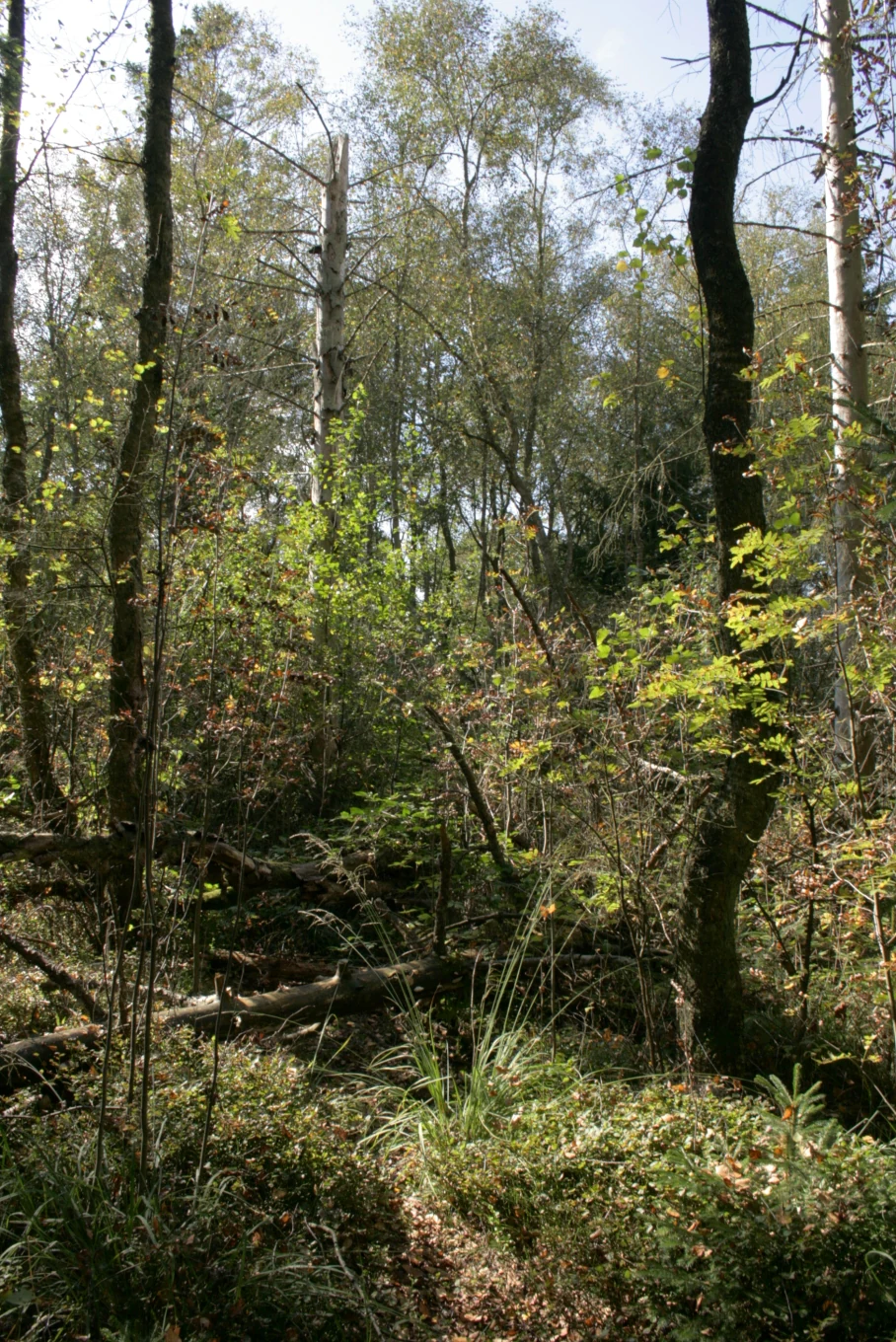
A dense, natural forest scene with sunlight filtering through thin tree trunks, featuring mossy fallen logs and lush undergrowth.
Natural decomposition of fallen timber on the forest floor in Draved Skov.

Draved Skov history and protected-area timeline

The forest that we see today in Draved Skov is in significant part the product of its historical inaccessibility. For long stretches of Danish forestry history, the woodland was surrounded by open bog, including the large Kongens Mose to the west. Extracting timber from a wet, bog-edged forest was slow and unprofitable, so commercial logging largely passed the area by. In a country where most lowland forest was cleared or heavily exploited centuries ago, this single factor allowed Draved Skov to retain an unusually high proportion of old-grown trees and undisturbed soil.

Formal protection began in 1948, when approximately ten hectares were designated as untouched forest dedicated to scientific study. In 1963 the protected area was expanded to include an additional twenty hectares of old forest and roughly fifty hectares of bog with a forest-like canopy. The most consequential step came in 1994, when the Danish authorities decided to convert the management of the entire approximately 250 hectare forest to untouched forest. As part of this shift, conifer plantations of spruce were cleared and the drainage ditches that had been cut through the area were filled in or dammed, allowing natural hydrology to return to large parts of the site.

In 2022 the forest, together with the adjacent Kongens Mose raised bog, was designated as a Danish national nature park, drawing on the country's broader rewilding and ecologically driven forest policy. The combined national nature park, Naturnationalpark Draved Skov og Kongens Mose, covers about 564 hectares. The same area is also recognized at the European level through Natura 2000, where it forms part of site number 99 and is listed under both the Habitats Directive and the Birds Directive.

Draved Skov landscape and geographic character

The landscape of Draved Skov is shaped by a sharp but locally compact contrast between two glacial landforms. At its core lies part of Kongensbjerg bakkeø, a small moraine hill of clay-rich glacial till left behind by the Weichselian glaciation. Extending away from this hill are outwash plains that originated as small, flat sand dunes deposited on top of the clay, and which were later buried under a thin mor-type humus layer. Together these landforms produce a gently undulating terrain in which elevation differences are small but substrate differences are dramatic.

The most visible landscape consequences of this varied substrate are recognizable in transitions between forest types. On the clay-rich uplands the forest is denser and more species-rich, with deeper, mull-like soils that support oak and linden and a richer understory. As the ground dips into sandy depressions, the soil becomes drier and more nutrient-poor, the canopy thins slightly, and the understory becomes more acidic. In the lowest, wettest hollows and along the fringes of the bog, the substrate becomes saturated and humus-rich, and alder comes to dominate. These transitions can occur over very short distances, producing a genuinely mosaic-like woodland with no single uniform character.

Surrounding the forest, the broader landscape is shaped by bog and former heath. The neighboring Kongens Mose is one of Denmark's largest remaining raised bogs and, after the end of peat cutting and adjacent agriculture, has been allowed to rewet so that large parts of it now stand under water. The horizon around Draved Skov is therefore low, flat, and dominated by wetland rather than by dramatic relief. Visually the forest reads as a wooded island rising gently out of an open, waterlogged plain.

Draved Skov ecosystems, habitats, and plant life

Ecologically, Draved Skov is unusual for a Danish forest because of the intensity with which water and soil type together control vegetation. Annual precipitation close to 900 millimeters, combined with a consistently high groundwater table, produces permanently moist conditions across most of the site. This hydrology suppresses the kind of dry, acid-heath understory that dominates many other Danish woodlands and instead supports a mixed broadleaf forest community rich in moisture-loving species.

The varied soil mosaic translates directly into a patchwork of forest types rather than a uniform block. Clay-rich mull soils favor oak and linden with a richer ground flora. Poorer, sandy outwash soils produce more open stands with birch and rowan. Humus-rich, waterlogged hollows support alder-dominated wetland forest. Holly, hazel, hawthorn, and wild apple form a structurally important shrub layer through much of the woodland. The high water table also slows the decomposition of fallen wood, allowing dead trunks, fallen branches, and standing snags to accumulate, which in turn supports a specialized community of fungi, lichens, and invertebrates.

Because commercial logging ceased across the entire forest in 1994 and spruce plantations were removed, the area now exhibits the kind of structural complexity normally associated with old-growth forest. Multiple canopy layers coexist; regeneration of young trees happens continuously in small gaps; and the proportion of deadwood is high by Danish standards. The neighboring bog extends this ecological gradient further by adding open-water and peatland habitats directly adjacent to the forest, so that woodland, mire, and transitional wetland form a single coherent ecological system.

Draved Skov wildlife and species highlights

Wildlife significance at Draved Skov is closely tied to the combination of mature broadleaf forest, abundant deadwood, and adjacent open wetland. The presence of large amounts of standing and fallen dead wood supports saproxylic insects, specialist fungi, and the wider community of species that depend on decaying timber, which is a feature increasingly rare in intensively managed Danish landscapes.

The surrounding Kongens Mose and the wet margins of the forest itself provide habitat for mire-associated birdlife. The wider area is formally designated as a Natura 2000 bird protection area, reflecting its value for breeding, migrating, and wintering birds associated with raised bogs, wet woodland, and forest edges. Mammal presence is consistent with mainland Southern Jutland, with the woodland structure favoring forest-dwelling species that require cover, deadwood, and undisturbed ground for nesting and feeding.

Although the source material does not support a detailed species-by-species inventory, the broader ecological pattern is clear: Draved Skov is shaped as much by what is allowed to decay as by what grows. Rotting logs, mossy trunks, waterlogged hollows, and the gradual turnover of individual trees are themselves the habitat on which much of the site's distinctive fauna depends.

Draved Skov conservation status and protection priorities

Draved Skov is centrally important to forest conservation in Denmark, primarily because it is the country's largest continuous block of untouched lowland broadleaf forest. Its conservation value is rooted less in rarity of individual species than in the rarity of intact forest process. Long-term protection has allowed natural regeneration, natural mortality, and natural canopy turnover to proceed without human interference, producing structural features such as multiple age cohorts, abundant deadwood, and a varied understory that are missing from most managed Danish forests.

Conservation management of the site has moved through three clear phases. The first, from 1948, was a research-driven protection of a ten hectare core area. The second, from 1963, expanded protection to include older forest and wooded bog. The decisive third phase began in 1994, when the entire forest, around 250 hectares, was formally taken out of production. The removal of spruce plantations and the blocking of drainage ditches that accompanied this change restored hydrological conditions closer to those under which the original forest developed.

The site is recognized at multiple levels of conservation policy. Regionally, it is embedded in the new Danish national nature park system through the 2022 designation of Naturnationalpark Draved Skov og Kongens Mose. At European level, it is part of Natura 2000 area number 99, Kongens Mose and Draved Skov, and is designated both as a habitat area under the Habitats Directive and as a bird protection area under the Birds Directive. Together these designations cement Draved Skov's role as a reference site for natural forest dynamics and for bog-forest coexistence in Denmark.

Draved Skov cultural meaning and human context

Draved Skov sits in Southern Jutland, the region historically known as Grænselandet, the borderland that has shifted between Danish and German control multiple times in modern history. The forest's name itself encodes a piece of this regional culture: the Danish word 'dra-ved' carries the sense of 'sump-skov', or swamp forest, reflecting a long-standing local understanding of the woodland as a wet, low-lying place shaped by its boggy surroundings.

The forest also has a strong place in the history of Danish forest science. From 1948 onward, the protected core of Draved Skov served as a long-term research site, and work there, including the more than fifty year Danish research project led by figures such as Peter Friis Møller and Richard Bradshaw, helped establish scientific understanding of how untouched Danish broadleaf forest actually develops. This dual identity, as both a quiet, bog-edged woodland and a foundation of Danish forest ecology, gives the site a cultural weight that extends beyond the local region.

Top sights and standout views in Draved Skov

Draved Skov's strongest distinguishing features are its status as Denmark's largest single block of untouched forest, the unusually fine soil-driven mosaic of forest types within a small area, and the high proportion of natural deadwood. These combine to give the site a genuinely primeval character that contrasts with most other Danish woodlands, which remain under some form of active management.

The forest is paired with one of Denmark's largest remaining raised bogs, Kongens Mose, producing an integrated forest-and-mire landscape rather than a simple woodland block. It is recognized under multiple conservation frameworks, including Danish national nature park status from 2022 and European Natura 2000 designations as both a habitat area and a bird protection area, reinforcing its role as a reference site for natural forest and bog conservation.

Best time to visit Draved Skov

Conditions at Draved Skov shift with the seasons in ways that affect both atmosphere and visible forest dynamics. Spring brings fresh green growth and active regeneration in the understory, with the wettest areas still saturated after winter precipitation. Summer is the period of deepest shade under the broadleaf canopy, when the variation in soil moisture is most easily felt on the ground and when the bog margins of Kongens Mose are most biologically active.

Autumn highlights the mixed deciduous structure of the forest itself, with oak, linden, and alder turning in sequence and producing a layered display of color across the woodland. In winter, when the broadleaf canopy has dropped its leaves, the underlying structure of the forest becomes most visible: the mosaic of canopy types, the abundance of standing and fallen deadwood, and the open vistas toward the surrounding bog are all easier to read against a bare-branch background. Because the site relies on its high groundwater table, visits in drier summer conditions will read very differently from visits after sustained autumn rainfall.


Monthly climate preview

Long-term representative temperature and precipitation averages for Draved Skov

Draved Skov Climate Normals and Measured Monthly Weather Patterns

Representative coordinate measurements record the annual temperature curve and monthly precipitation rhythm for Draved Skov from 1991 to 2020. Examining the complete twelve-month dataset clarifies long-term climate normals across the protected area.
Annual mean9 °C
2 °C17 °C
Jan
Feb
Mar
Apr
May11°
Jun14°
Jul17°
Aug17°
Sep15°
Oct10°
Nov
Dec
Warmest month
August

17.3 °C

Coolest month
February

1.9 °C

Wettest month
October

2.9 mm/day

Driest month
April

1.4 mm/day

Park location guide

Geography guide, regional context, and park location map for Draved Skov

Draved Skov park geography, regions, and map view in Denmark

Understand where Draved Skov sits in Denmark through a broader geographic reading of the surrounding landscape, nearby location context, and its mapped position within the national park landscape.

How Draved Skov fits into Denmark

Denmark is a constitutional monarchy and Nordic country in Northern Europe. It is the southernmost of the Scandinavian countries, bordering Germany to the south, Norway to the north, and Sweden to the southwest. The country consists of the Jutland peninsula and an archipelago of islands, with Copenhagen as its capital and largest city. Denmark has a population of over 6 million and is characterized by flat, arable land, sandy coasts, and a temperate climate.

Wider geography shaping Draved Skov in Denmark

Denmark occupies the Jutland peninsula and roughly 406 islands in Northern Europe. It is situated between the North Sea to the west and the Baltic Sea to the east. The country borders Germany to the south and is connected to Sweden via the Øresund Bridge. Denmark is predominantly flat terrain with low elevation, the highest point being Møllehøj at 170.86 meters.

Map view of Draved Skov

Use this park location map to pinpoint Draved Skov in Denmark, understand its exact geographic position, and read its mapped placement within the surrounding landscape more clearly.

Pigeon | © OpenStreetMap contributors

Explore protected habitats, glacial terrain, and forest scenery across Southern Jutland

Draved Skov Photos and Landscape Imagery: Visualizing Denmark's Untouched Woodland

Visual records capture the complex habitat mosaic and glacial landforms that define Draved Skov in southern Denmark. Photographic documentation reveals the undisturbed broadleaf canopy, fallen deadwood, and adjacent wetland environments.

A dense, natural forest scene with sunlight filtering through thin tree trunks, featuring mossy fallen logs and lush undergrowth.

Park atlas

Compare nearby national parks and regional conservation areas across Southern Jutland

Explore Parks Near Draved Skov and Surrounding Protected Landscapes

Browsing other parks near Draved Skov allows visitors to examine related lowland forests, wetlands, and protected natural terrain across the surrounding region. Extending the geographic comparison helps place this untouched woodland within a broader network of European conservation landscapes.
National parkDenmark
About 14 km away#1 closest

Northwest

Wadden Sea National Park: Denmark's Premier Tidal Wetland and Migratory Bird Sanctuary

Mapped boundaries and unique protected landscape exploration.

Wadden Sea National Park is a vast national park encompassing the Danish portion of the Wadden Sea, a globally significant tidal wetland. Recognized for its critical role in bird migration, hosting millions of birds annually, it features a distinctive landscape of tidal flats, salt marshes, coastal dunes, and barrier islands. This protected area offers a unique lens through which to explore dynamic coastal geography, intertidal ecosystems, and the conservation of a World Heritage Site.

Area
1,466 km²
Established
2010
IUCN
II
Relief
Lowland
Watercolor illustration of a landscape with green hills, a body of water, and grassy foregrounds
National parkSchleswig-Holstein
About 24 km away#2 closest

South

Schleswig-Holstein Wadden Sea National Park: Germany's Largest Protected Tidal Landscape

Explore the mapped geography of this vital North Sea national park.

Schleswig-Holstein Wadden Sea National Park is a monumental protected area, recognized globally as a UNESCO World Heritage Site for its extraordinary tidal wetland ecosystem. This page offers detailed insights into its geographic scope, from the North Frisian Islands to the Elbe estuary, highlighting the dynamic interplay of mudflats, salt marshes, and coastal terrain. Discover the park's critical role as a migratory bird flyway and marine nursery, providing rich data for geographic and atlas exploration of this unique North Sea protected landscape.

Area
4,410 km²
Established
1985
IUCN
II
Visitors
1.7M annual
Protected areaSchleswig-Holstein
About 28 km away#3 closest

South

FFH-Gebiet Wälder an der Lecker Au: Protected Forest Landscapes and Geest Geography

A mapped Natura 2000 deciduous woodland corridor in North Friesland

FFH-Gebiet Wälder an der Lecker Au comprises three specialized sub-areas of ancient deciduous woodland in Schleswig-Holstein. This protected landscape documents centuries of forest continuity, hosting diverse habitats including beech, oak, and alluvial forests that anchor the regional biotope network within the flat Lecker Geest terrain.

Area
0.5 km²
Established
2004
Relief
Lowland
Climate
Temperate
Nature reserveSchleswig-Holstein
About 48 km away#4 closest

Southeast

FFH-Gebiet Wald-, Moor- und Heidelandschaft der Fröruper Berge und Umgebung Landscape Profile

Glacial moraine ridges and wetland mosaic in Schleswig-Holstein.

Analyze the protected boundaries and natural terrain of this German nature reserve. The site hosts a rare combination of beech woodland, transition mires, and sandy inland dunes that represent the complex ecological transition within the Obere Treenelandschaft region.

Area
9.4 km²
Established
2004
Relief
Upland
Climate
Temperate
Protected landscapeAls
About 49 km away#5 closest

East

Naturpark Nordals: Protected Landscape and Glacial Geography on the Island of Als, Denmark

Coastal landscapes, tunnel valleys, and restored fjord basins

Naturpark Nordals offers a deep look into the glacial history of the island of Als. This protected landscape is defined by extensive meltwater channels that now house a series of significant lakes, including Mjels Sø and Bundsø. The area provides a structured view of Danish coastal and lacustrine geography where former fjord inlets have been re-established to create a rich, interconnected wetland environment within a working agricultural setting.

Area
19.28 km²
Established
2020
Relief
Upland
Climate
Temperate
Nature reserveSchleswig-Holstein
About 52 km away#6 closest

Southeast

Wälder im Süderhackstedtfeld: Protected Nature Reserve and Geest Landscape Atlas

Examining forest habitats in northern Schleswig-Holstein

Trace the boundaries of Wälder im Süderhackstedtfeld, a notable nature reserve in Schleswig-Holstein. This site contains priority atlantic beech and oak forest types within a classic glacial ridge topography, showcasing long-term woodland continuity and structured forest restoration within a compact geographic footprint.

Area
0.76 km²
Established
2004
Relief
Upland
Climate
Temperate
Watercolor illustration of a landscape featuring a winding river through a green valley with rolling purple hills and trees in soft pastel colors
Nature reserveSchleswig-Holstein
About 54 km away#7 closest

Southeast

FFH-Gebiet Wälder an der Bondenau: Nature Reserve Geography and Mapped Forest Landscapes

Protected lowland forest blocks in the Angeln peninsula of Germany

Investigate the protected deciduous woodlands of FFH-Gebiet Wälder an der Bondenau through detailed geographic context. This Natura 2000 site contains historic beech and oak-hornbeam forest stands within a glacial tunnel valley, providing significant habitat conservation and insight into the environmental heritage of Schleswig-Holstein.

Area
1.26 km²
Established
2004
Protected areaSchleswig-Holstein
About 59 km away#8 closest

South

Wälder der Ostenfelder Geest: Geographic Mapping of Protected Forests in Northern Germany

A twelve-parcel woodland mosaic in the Schleswig-Holstein Geest.

Wälder der Ostenfelder Geest serves as a prime example of lowland conservation. This protected area connects diverse forest types across a glacial landscape, providing a stable habitat for beech and oak woodland communities while preserving the historic character of the Bredstedt-Husumer terrain.

Area
7.33 km²
Established
2004
Relief
Lowland
Climate
Temperate

Common questions about visiting, size, designation, and location context for Draved Skov

Draved Skov FAQs for park facts, access, geography, and protected area context

Find quick answers about Draved Skov, including protected-area facts, park geography, trail and visitor context, and how the park fits into its surrounding country and regional landscape.
MoriAtlas Explorer

Continue Your Protected Areas Search Across the Global Atlas

Deepen your exploration by continuing the structured search for national parks and protected areas worldwide. Utilize the comprehensive filtering capabilities to compare different conservation landscapes and refine your understanding of global park geography. Discover more about the distribution and characteristics of protected natural areas.

Global natural geography