
Mori Atlas logo
Nature reserveDury Nature Reserve

A strictly protected wetland complex in northern Poland featuring dystrophic lakes and peat bog habitats

Dury Nature Reserve: Mapped Protected Landscapes and Wetland Geography in Kuyavian-Pomeranian Voivodeship

(Rezerwat przyrody Dury)

Dury Nature Reserve acts as a vital conservation site within the Bory Tucholskie region of northern Poland. This fragmented wetland complex preserves rare assemblages of acidic, nutrient-poor water bodies and specialized peatland flora. Located within the Wda Landscape Park, the reserve protects delicate hydrological patterns and distinct Sphagnum-dominated ecosystems that reflect the glacial history of the surrounding Tuchola Forest landscape.

peatlandbogdystrophic lakesnature reservestrict protectionBory Tucholskie
A graphic illustration depicting a waterfall dropping from high cliffs into a calm lake, framed by stylized pine trees in the foreground.

Dury Nature Reserve

Nature reserve

Park overview

Structured park overview, official facts, and landscape profile for Dury Nature Reserve

Dury Nature Reserve park facts, protected area profile, and essential visitor context

Review the core facts for Dury Nature Reserve, including designation, size, terrain, visitor scale, habitats, and operating context in one park-focused overview.

About Dury Nature Reserve

Dury Nature Reserve is a compact but ecologically focused protected area in northern Poland, dedicated to the preservation of peatland and bog ecosystems that have become rare in the broader landscape. It lies within the gmina of Osie in Świecie County, in the Bory Tucholskie, a region long associated with extensive forests, glacial landforms, and a scattered network of wetlands. Administratively, the reserve falls within the Kuyavian-Pomeranian Voivodeship and is managed in connection with the Osie Forest District, specifically through the Stara Rzeka forestry unit.

The reserve sits within the larger Wda Landscape Park, a designation that frames Dury as one element in a broader protected landscape rather than an isolated fragment. The landscape park context is important: it indicates that the surrounding forests, waterways, and transitional habitats are also subject to some level of conservation planning, providing a wider matrix that supports the integrity of the reserve's core wetland features. The buffer zone surrounding Dury, covering approximately 51.67 hectares, reinforces this relationship by cushioning the strict reserve from forestry operations and other land-use pressures.

Ecologically, Dury is defined by its fragmented structure. The reserve is composed of five separate pieces, but its ecological core consists of four small intra-forest dystrophic lakes encircled by peat bog. Dystrophic lakes are acidic, humus-rich water bodies fed largely by surrounding peatlands; they typically support very limited planktonic life and develop distinctive submerged and floating vegetation. Around them, the bog vegetation includes mosses, sedges, Sphagnum mats, and a suite of specialist plants that together form one of the most threatened habitat types in lowland Poland.

The reserve's importance lies not in its scale but in the combination of habitats it preserves in close proximity. By protecting both dystrophic lakes and adjacent mires, Dury maintains the hydrological and ecological linkages that sustain bog plant communities. Its strict protection status places it among the more intensively safeguarded sites of its kind, recognizing both its rarity and its vulnerability to drainage, peat extraction, and forest-driven changes in water chemistry.

Quick facts and research context for Dury Nature Reserve

Dury Nature Reserve is a peatland-type strict nature reserve in the gmina of Osie, Świecie County, in the Kuyavian-Pomeranian Voivodeship. It lies within the Bory Tucholskie mesoregion, on the territory of the Stara Rzeka forestry unit of the Osie Forest District, and is part of the wider Wda Landscape Park.

The reserve covers a core area of 13.02 hectares, with an additional buffer zone of 51.67 hectares around it. It was established by order of the Minister of Forestry and the Wood Industry on 26 March 1975, reflecting mid-1970s Polish efforts to formalize protection for exceptional peatland and aquatic plant communities.

Protection and recognition

Examine terrestrial boundary parameters, management scope, and recognition history for Dury Nature Reserve.

Dury Nature Reserve Protection Status and Official Designation Records

Terrestrial boundary parameters and protection status records define the conservation framework established for Dury Nature Reserve. Official designation history and management scope details outline the documented administrative profile associated with the protected landscape.

Protection details

Protection scope
Terrestrial
Transboundary protection
No
Buffer area
0.52 km²
Park context

Deeper park guide and search-rich context for Dury Nature Reserve

Dury Nature Reserve history, landscape, wildlife, and travel context

Explore Dury Nature Reserve through its history, landscape character, ecosystems, wildlife, conservation priorities, cultural context, and seasonal travel timing in a structured park guide built for atlas discovery and search intent.

Why Dury Nature Reserve stands out

Dury is best known for its rare peatland vegetation and for the presence of multiple sundew species growing around its small dystrophic lakes. The combination of nutrient-poor, acidic waters and surrounding Sphagnum-dominated mires has produced plant communities that are unusual in Poland and that have been a central justification for the reserve's strict protection status. The reserve is also notable as one of several protected peatland sites in the Bory Tucholskie region, contributing to the broader mosaic of wetland habitats that characterize this part of the Tuchola Forest.
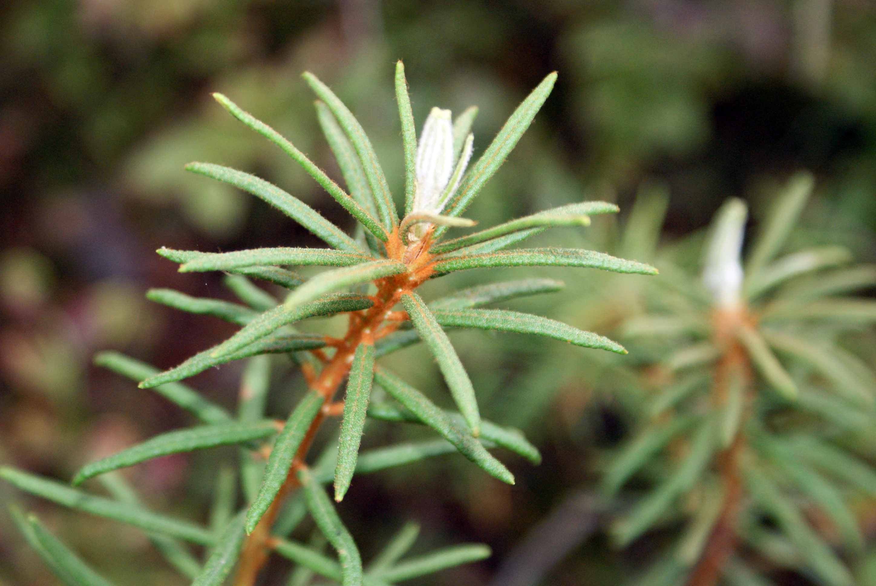
Close-up of a green, needle-leaved plant with small, pale buds at the tips of its stems.
Wild rosemary (Ledum palustre) found within the Dury Nature Reserve.

Dury Nature Reserve history and protected-area timeline

Dury Nature Reserve was established on 26 March 1975 by order of the Minister of Forestry and the Wood Industry. The formal act creating the reserve specified an initial area of 12.59 hectares, while the actual protected area has been recorded at 13.02 hectares. A surrounding buffer zone of 51.67 hectares was designated alongside the core reserve.

The reserve was founded specifically to preserve rare assemblages of aquatic and peatland vegetation in a region where such habitats were under increasing pressure from forestry and land management. By giving it strict protection status under Polish nature conservation law, the authorities sought to safeguard the dystrophic lakes and surrounding mires from direct human alteration, and to maintain the unusual plant communities that had developed within them. The reserve's creation can be seen as part of a broader 1970s pattern in Poland of formalizing protection for outstanding peatland and bog sites at a time when their ecological value was becoming more widely recognized.

Dury Nature Reserve landscape and geographic character

The landscape of Dury is shaped by the legacy of glacial activity that defined much of the Bory Tucholskie region. The reserve sits within a forested lowland setting, where the surrounding terrain consists of mixed coniferous and boggy woodland, with sandy outwash plains and subdued moraine forms in the wider area. The most striking physical features within the reserve are the small dystrophic lakes, which occupy shallow depressions in the peatland and reflect the dark, tea-stained waters typical of bog-fed water bodies.

Around the lakes, the landscape transitions into expanses of peat bog, with floating and grounded mats of Sphagnum mosses, sedge tussocks, and low ericaceous shrubs such as bog rosemary and cranberry species. The terrain within the bog is often soft and uneven, with water barely below the surface, creating a hummocky, saturated environment. The fragmented structure of the reserve, with five separate pieces, reflects the patchy distribution of suitable peatland and lake habitat within the surrounding forest matrix. Outside the reserve and its buffer zone, the forested character of the Tuchola Forest continues, with pine-dominated stands and managed woodland enclosing the protected core.

Dury Nature Reserve ecosystems, habitats, and plant life

Dury's ecological identity is built around peatland and dystrophic lake habitats, two closely linked ecosystem types that together support a distinctive flora. The dystrophic lakes are characterized by acidic, nutrient-poor conditions and high concentrations of humic substances, which give the water its dark color and limit the growth of typical aquatic vegetation. In this setting, only specially adapted water plants thrive, including white water lilies and the rarer northern water lily, both of which are recorded in the reserve.

The surrounding peatlands support plant communities typical of raised and transitional bogs. Sphagnum mosses dominate the ground layer, accompanied by sedges, cotton grasses, and ericaceous plants. Among the most notable species in the reserve are small cranberry, which is rare in Poland and characteristic of undisturbed bog habitats, and Scheuchzeria palustris, a specialist mire plant indicative of intact peatland conditions. The three species of sundew recorded here, including round-leaved, long-leaved, and intermediate sundews, are particularly characteristic of the reserve, as carnivorous plants of this kind depend on the open, nutrient-poor, and consistently wet bog surfaces that Dury still retains.

Ferns such as the crested shield fern also occur in the transitional woodland-mire habitats along the bog margins, adding to the botanical richness of the site. Overall, the nature of Dury is defined less by species abundance than by the persistence of ecological conditions that allow rare bog and dystrophic lake specialists to coexist in a relatively small area.

Dury Nature Reserve wildlife and species highlights

The wildlife profile of Dury is closely tied to its peatland and lake habitats, and is most distinctive at the level of invertebrate and plant communities that depend on acidic, nutrient-poor conditions. The presence of sundews is itself a marker of specialized invertebrate fauna, since these carnivorous plants capture and digest small insects adapted to bog surfaces, and their occurrence indicates a functioning food web built around the open mires.

The dystrophic lakes, while species-poor in fish because of their low pH and limited oxygen, can support characteristic invertebrates, amphibians, and aquatic invertebrates tolerant of humic conditions. Peatland edges and margins provide habitat for bog-specialist invertebrates and for species that rely on transitional wet-forest conditions. Although the source material emphasizes the botanical significance of the reserve, the broader landscape of the Bory Tucholskie supports a wider range of forest wildlife, and the reserve's protected core functions as part of that wider ecological network.

Dury Nature Reserve conservation status and protection priorities

Dury Nature Reserve is significant from a conservation perspective because it safeguards one of the rarer peatland complexes in the Bory Tucholskie region. Peatlands and dystrophic lakes are among the most threatened habitat types in lowland Poland, vulnerable to drainage, peat extraction, afforestation changes, and shifts in hydrology caused by surrounding forestry. By placing the area under strict protection, Dury provides a buffer against these pressures and preserves conditions that are difficult to restore once lost.

The reserve's location within the Wda Landscape Park strengthens its conservation value by embedding it in a broader landscape-scale protection framework, where surrounding land uses are subject to additional planning constraints. The combination of a strict core area and a sizeable buffer zone further supports the maintenance of hydrological stability, which is essential for sustaining both the bog vegetation and the chemistry of the dystrophic lakes. Together, these measures ensure Dury continues to serve as a reference site for peatland and dystrophic lake habitats in the region.

Top sights and standout views in Dury Nature Reserve

Dury stands out as a compact reserve that concentrates multiple botanical rarities within a very small area. The combination of four dystrophic lakes and surrounding peat bog, protected under strict reserve status, makes it a distinctive reference site for peatland conservation in the Bory Tucholskie.

Its occurrence within the Wda Landscape Park and its substantial buffer zone connect it to a wider framework of landscape-level protection, increasing its functional value beyond its modest core area. The presence of multiple sundew species, together with small cranberry, Scheuchzeria, and specialized ferns, defines Dury as a site of concentrated botanical interest rather than broad-scale scenic value.

Best time to visit Dury Nature Reserve

Dury is a strict nature reserve, and any visitation is primarily for educational or scientific purposes rather than general tourism. The period from late spring through early autumn is typically the most favorable window for observing bog vegetation in active growth, when Sphagnum mats, cotton grasses, and ericaceous plants are at their most visible. Late summer is often a good time to observe berry-producing species such as small cranberry, while the open character of the bog surfaces makes sundews and other specialist plants most easily seen in warmer months.

Winter can also be a striking time to visit the broader forest landscape of the Tuchola Forest, although frozen, wet peatland surfaces may restrict access within the reserve itself. Since the reserve is a protected site, visitors should follow any access guidance from the managing forest district and avoid disturbing the sensitive hydrological conditions that sustain its ecological value.
Monthly climate preview

Long-term representative monthly temperature and precipitation rhythm

Dury Nature Reserve Climate Normals and Annual Temperature Patterns

Representative coordinate measurements reveal the multi-year temperature and precipitation rhythm across Dury Nature Reserve from 1991 to 2020. Examining the complete monthly climate normals offers detailed historical baseline data for analytical comparison.
Annual mean8 °C
-3 °C19 °C
Jan-3°
Feb-2°
Mar
Apr
May13°
Jun17°
Jul19°
Aug19°
Sep14°
Oct
Nov
Dec-1°
Warmest month
July

19.4 °C

Coolest month
January

-3 °C

Wettest month
July

2.6 mm/day

Driest month
April

1.2 mm/day

Park location guide

Geography guide, regional context, and park location map for Dury Nature Reserve

Dury Nature Reserve park geography, regions, and map view in Poland

Understand where Dury Nature Reserve sits in Poland through a broader geographic reading of the surrounding landscape, nearby location context, and its mapped position within the national park landscape.

How Dury Nature Reserve fits into Poland

Poland, officially the Republic of Poland, is a Central European country spanning from the Baltic Sea in the north to the Carpathian Mountains in the south. It borders Germany, Czech Republic, Slovakia, Ukraine, Belarus, Lithuania, and Kaliningrad Oblast. The country has a temperate climate, diverse landscapes, and is known for its rich history, cultural heritage, and strong economic position within the EU.

Wider geography shaping Dury Nature Reserve in Poland

Poland occupies 312,696 km2 in Central Europe, extending from the Baltic Sea coast in the north to the Sudetes and Carpathian Mountains in the south. It borders Germany to the west, Czech Republic and Slovakia to the south, Ukraine and Belarus to the east, and Lithuania and Kaliningrad Oblast to the northeast. The landscape includes lowland plains, uplands, and mountain ranges.

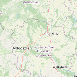
Map view of Dury Nature Reserve

Use this park location map to pinpoint Dury Nature Reserve in Poland, understand its exact geographic position, and read its mapped placement within the surrounding landscape more clearly.

Pigeon | © OpenStreetMap contributors

Location context for Dury Nature Reserve

Kuyavian-Pomeranian Voivodeship

Explore the terrain, dystrophic lakes, and protected bog habitats of northern Poland.

Visualizing Dury Nature Reserve: Landscape Photos and Scenery

Examine detailed photographs of Dury Nature Reserve to observe its unique dystrophic lakes and surrounding Sphagnum mires. Visualizing these protected wetland environments reveals the distinct ecological character and fragile terrain of this northern Polish sanctuary.

Close-up of a green, needle-leaved plant with small, pale buds at the tips of its stems.

A view through foreground pine trees looking out at a calm lake surrounded by grasses and bog vegetation with a dense forest in the background.

Park atlas

Explore surrounding regional conservation lands and wetland habitats

Other Protected Areas and Parks Near Dury Nature Reserve

Compare Dury Nature Reserve with adjacent protected areas across the surrounding lowland forest landscape. Continued exploration reveals connected wetland habitats and regional conservation networks within the wider Bory Tucholskie terrain.
A minimalist watercolor painting showing a calm lake or wetland surrounded by soft green trees and gentle hills under a light sky.
Protected areaKuyavian-Pomeranian Voivodeship
Mapped location lies within the park boundary#1 closest

Southeast

Sandr Wdy Protected Area: Glacial Geography and Wetland Habitats in Northern Poland

An essential reference area for Bory Tucholskie forest ecology.

Sandr Wdy is a distinctive Natura 2000 protected area shaped by post-glacial processes. The landscape features a flat outwash plain punctuated by lake basins, river valleys, and diverse mire systems. With multiple strict nature reserves integrated into its boundaries, the site provides a comprehensive view of how hydrological and soil conditions influence habitat distribution within the broader forest landscape of Poland.

Area
63.21 km²
Established
2011
Relief
Lowland
Climate
Temperate
Protected landscapeKuyavian-Pomeranian Voivodeship
Mapped location lies within the park boundary#2 closest

Southwest

Wdecki Park Krajobrazowy: Protected Landscape Atlas and Regional Geography

Forest and river basin terrain in Poland

Examine the geographic foundation of Wdecki Park Krajobrazowy, a protected landscape characterized by the Wda River drainage, glacial erratics, and extensive pine forests. The area supports a rich variety of wetland flora, mires, and managed reservoirs such as the Żur, making it a significant conservation landmark within the wider Bory Tucholskie region of northern Poland.

Area
191.77 km²
Established
1993
Relief
Lowland
Climate
Temperate
A panoramic watercolor illustration showing a calm lake bordered by pine trees and patches of pink shrubs under a pale sky.
Nature reservePoland
About 2.9 km away#3 closest

Southeast

Rezerwat przyrody Miedzno: Wetland and Peatland Protected Area in Northern Poland

Geographic atlas of the Miedzno nature reserve and its glacial valley.

Rezerwat przyrody Miedzno represents a vital ecological corridor in Poland, defined by its flow-through lake, alder-birch swamp forests, and rare marshland flora. This nature reserve, situated within the Wdecki Landscape Park, provides a detailed view into the post-glacial topography and avian conservation landscapes of the Bory Tucholskie mesoregion.

Area
0.885 km²
Established
1968
Relief
Lowland
Climate
Temperate
Nature reserveKuyavian-Pomeranian Voivodeship
About 6.9 km away#4 closest

Northeast

Rezerwat przyrody Jezioro Łyse: Protected Peatland and Bog Lake Geography in Poland

Wetland ecosystems of the Tuchola Forest region

Rezerwat przyrody Jezioro Łyse represents a preserved 20.55 hectare peatland basin in the Kuyavian-Pomeranian Voivodeship. This nature reserve highlights the intersection of open water, bog pine forests, and sphagnum-dominated peatlands, providing a critical study of lowland wetland terrain and protected plant communities in northern Poland.

Area
0.206 km²
Established
2006
Relief
Lowland
Climate
Temperate
A horizontal watercolor illustration showing a calm lake surrounded by greenery and distant rolling hills, with reeds in the foreground.
Nature reserveKuyavian-Pomeranian Voivodeship
About 7.4 km away#5 closest

West

Rezerwat przyrody Jezioro Piaseczno: Nature Reserve and Regional Landscape Geography

Protected post-glacial lake habitats within the Bory Tucholskie region.

Located in the Kuyavian-Pomeranian Voivodeship, this nature reserve protects a rare, high-purity glacial lake and its dense woodland surroundings. The area offers a detailed view of post-glacial landscape formation, featuring a complex mix of mires, alder-ash riparian forests, and dry coniferous stands that define the natural character of the Polish northern lake district.

Area
1.59 km²
Established
2001
Relief
Lowland
Climate
Temperate
Nature reservePomeranian Voivodeship
About 13 km away#6 closest

East

Rezerwat przyrody Jezioro Udzierz Nature Reserve Geographic and Ecological Overview

Wetland habitat mosaic in the Pomeranian Voivodeship

Rezerwat przyrody Jezioro Udzierz protects a compact yet biodiverse wetland mosaic centered on Lake Udzierz. Located in the heart of the Bory Tucholskie forest, the reserve integrates open water, reedbeds, peatlands, and wet meadows into a single, cohesive ecological unit. This detailed view examines the reserve's protected status, landscape composition, and its vital role as a refuge for bird species within the wider geography of northern Poland.

Area
2.299 km²
Established
2000
Relief
Lowland
Climate
Temperate
Protected landscapeKuyavian-Pomeranian Voivodeship
About 18 km away#7 closest

West

Tuchola Landscape Park: Mapped Protected Area and Riverine Geography in Poland

Pine-covered outwash plains and the meandering Brda River corridor

Covering a significant portion of northern Poland, Tuchola Landscape Park protects a distinctive postglacial landscape of sandy plains and dense pine forests. The park geography is anchored by the Brda River, which flows through a series of rapids and breakthroughs before reaching deep into the surrounding pine-clad outwash plain. Detailed map data provides insight into the park's eight nature reserves, which preserve critical wetland, bog, and riverine habitats.

Area
369.83 km²
Established
1985
Relief
Lowland
Climate
Temperate
Watercolor painting of a wide, soft-focus river valley landscape with gentle hills, green vegetation, and a winding waterway.
Protected landscapeKuyavian-Pomeranian Voivodeship
About 26 km away#8 closest

South

Chełmiński Park Krajobrazowy: Geographic Overview of Protected Lands in Kuyavian-Pomeranian

Glacial moraine terrain and Vistula valley protected landscapes

Chełmiński Park Krajobrazowy preserves a compact, high-contrast landscape where glacial moraine hills meet the active river corridors of the Lower Vistula. The area is defined by its five distinct nature reserves that safeguard unique slope habitats, island-like floodplain forests, and post-glacial lake basins, offering an essential reference for studying the geomorphology of the Polish lowlands.

Area
223.36 km²
Established
1998
Scope
Terrestrial
Water
Major water bodies

Common questions about visiting, size, designation, and location context for Dury Nature Reserve

Dury Nature Reserve FAQs for park facts, access, geography, and protected area context

Find quick answers about Dury Nature Reserve, including protected-area facts, park geography, trail and visitor context, and how the park fits into its surrounding country and regional landscape.
MoriAtlas Explorer

Continue Your Protected Areas Search Across the Global Atlas

Deepen your exploration by continuing the structured search for national parks and protected areas worldwide. Utilize the comprehensive filtering capabilities to compare different conservation landscapes and refine your understanding of global park geography. Discover more about the distribution and characteristics of protected natural areas.

Global natural geography