
Mori Atlas logo
Nature reserveEhemalige Tongrube von Mainhausen

Examining the ecological significance of this former clay pit and Main river floodplain

Ehemalige Tongrube von Mainhausen: A Protected Wetland Landscape and Nature Reserve in Hessen

(Naturschutzgebiet Ehemalige Tongrube von Mainhausen)

The Ehemalige Tongrube von Mainhausen serves as a critical nature reserve and bird sanctuary within the lower Main valley of Hessen, Germany. This 15 hectare site, which preserves a former clay pit lake and adjacent river shorelines, provides a essential mosaic of wetland habitat for waterfowl and rare breeding bird populations. Its protected status reflects the successful transition of post industrial land into a key refuge for aquatic biodiversity in the region.

nature reserveformer clay pitwetlandlake habitatwaterbirdsbird sanctuary
A stylized flat vector illustration showing a calm lake in the foreground, surrounded by a coniferous forest, with a pale sun setting or rising in the background.

Ehemalige Tongrube von Mainhausen

Nature reserve

Park overview

Structured park overview, official facts, and landscape profile for Ehemalige Tongrube von Mainhausen

Ehemalige Tongrube von Mainhausen park facts, protected area profile, and essential visitor context

Review the core facts for Ehemalige Tongrube von Mainhausen, including designation, size, terrain, visitor scale, habitats, and operating context in one park-focused overview.

About Ehemalige Tongrube von Mainhausen

The Ehemalige Tongrube von Mainhausen is a compact but ecologically significant protected area in the Rhine-Main region of Germany. It lies in the municipality of Mainhausen, in the eastern part of the Offenbach district of Hesse, just north of the state border with Bavaria and within the broader floodplain of the Main river. The site was originally a clay extraction pit; after the extraction activity ended, the pit filled with water, creating a small lake landscape that gradually developed into a habitat complex of considerable ecological value.

The reserve is small in absolute terms, covering roughly 15 hectares, but its protected status carries substantial weight. It is simultaneously designated as a nature reserve under Hessian law and as a Bird Protection Area (Vogelschutzgebiet) under the European Natura 2000 framework, the latter on the same 15.59 hectares. This dual recognition reflects the site's dual function: it is at once a local habitat refuge and a node in the European network of important bird areas.

The character of the area is shaped by its origin. The open water of the former clay pit, the transitional shoreline zones, and the riverbank vegetation of the nearby Main together create a mosaic of aquatic, wetland, and floodplain habitats. This mosaic supports not just waterbirds, but also amphibians, insects, and a near-natural plant community typical of the lower Main floodplain. For a region dominated by agriculture, infrastructure, and expanding settlements around Frankfurt, the Tongrube represents a relatively rare concentration of wetland habitat.

Geographically, the reserve is situated in a triangle formed by the Mainflingen district of Mainhausen to the north, the A 45 motorway to the east, and the L 2310 road to the south. Despite this proximity to roads and residential areas, the site functions as a quiet refuge for sensitive species. Its elevation, between roughly 120 and 125 meters above sea level, places it firmly within the lowland character of the Untermainebene, the lower Main plain.

Quick facts and research context for Ehemalige Tongrube von Mainhausen

The Ehemalige Tongrube von Mainhausen is a nature reserve located in Mainhausen, in the Offenbach district of Hesse in central-western Germany. It covers approximately 15.59 hectares and lies at an elevation between roughly 120 and 125 meters above sea level. The reserve was formally designated in 2005 and is administered by the lower nature conservation authority (Untere Naturschutzbehörde) of the Offenbach district.

The protected area sits south of the Mainflingen district, framed by the A 45 motorway to the east and the L 2310 road to the south, within the broader lower Main river floodplain. In addition to its status as a German nature reserve (NSG), it is simultaneously designated as a Natura 2000 Bird Protection Area (SPA, Vogelschutzgebiet) on the same 15.59 hectares, highlighting its importance for waterbird conservation.

Protection and recognition

Documented terrestrial protection scope, boundary data, and international recognition sources

Ehemalige Tongrube von Mainhausen Protection Status and Natura 2000 Recognition

Comprehensive protected area records outline the terrestrial conservation framework and official Natura 2000 recognition for Ehemalige Tongrube von Mainhausen. Verified database metrics trace the documented designation history and administrative tracking details across official registers.

International recognition

Protection details

Protection scope
Terrestrial
Transboundary protection
No
WDPA ID
344582
Park context

Deeper park guide and search-rich context for Ehemalige Tongrube von Mainhausen

Ehemalige Tongrube von Mainhausen history, landscape, wildlife, and travel context

Explore Ehemalige Tongrube von Mainhausen through its history, landscape character, ecosystems, wildlife, conservation priorities, cultural context, and seasonal travel timing in a structured park guide built for atlas discovery and search intent.

Why Ehemalige Tongrube von Mainhausen stands out

The reserve is best known for its significance as a breeding, resting, and wintering site for waterbirds in the lower Main valley. The decisive event that led to its formal protection was the settlement of black-necked grebes (Schwarzhalstaucher) at the site in 1999; since then, the species has held its most important, and in some years its only, breeding occurrence in Hesse here. Beyond its importance for grebes and other waterbirds, the former clay pit lake is also valued for its amphibian populations, insect fauna, and the near-natural floodplain vegetation along the adjacent Main river banks. The site exemplifies how a small, post-industrial waterbody can become a critical node for wetland biodiversity within a heavily modified river landscape.
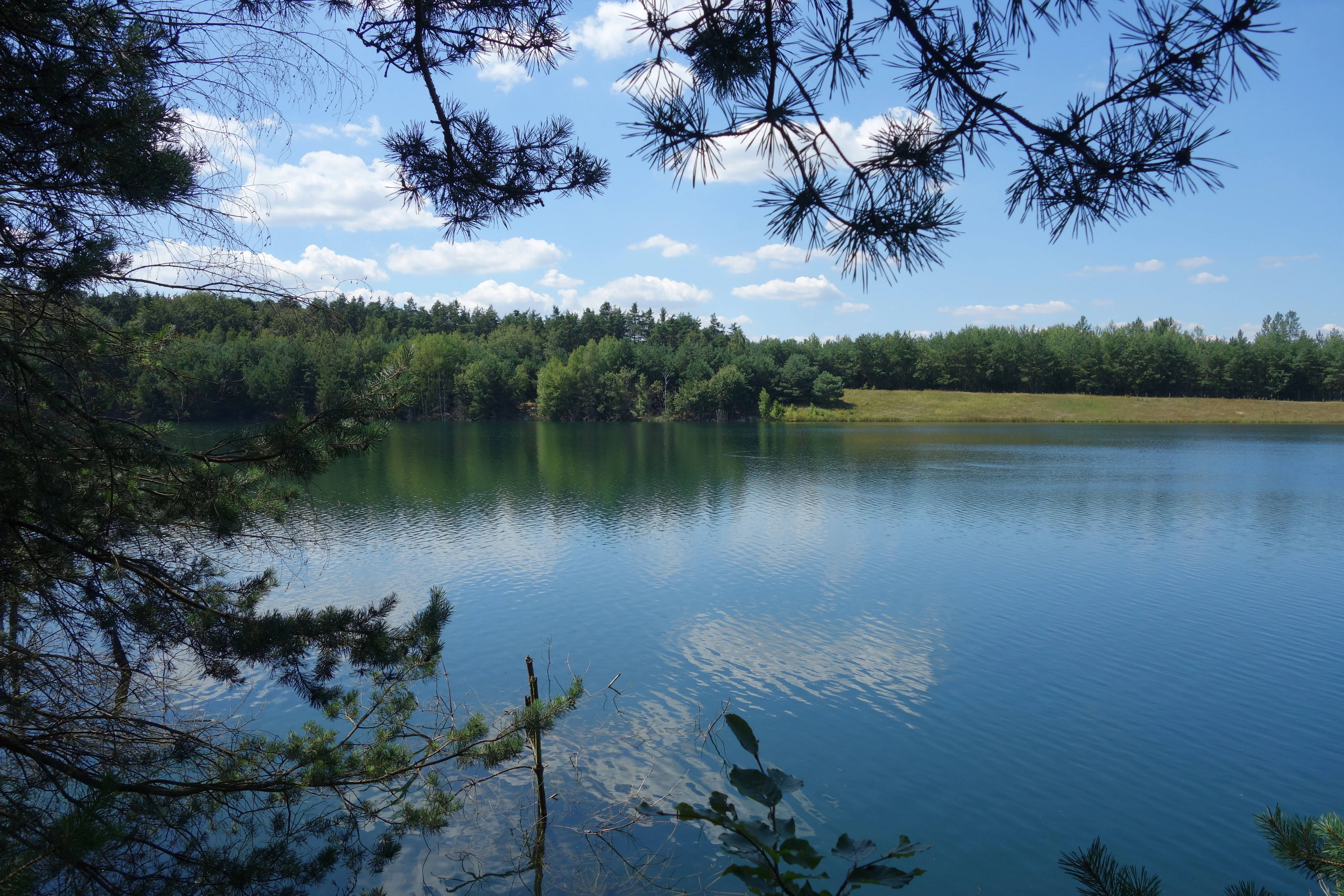
A peaceful lake at the Ehemalige Tongrube von Mainhausen nature reserve framed by pine branches in the foreground, with a lush green forest line and blue sky reflecting on the calm water.
A view across the water at the Former Clay Pit of Mainhausen nature reserve.

Ehemalige Tongrube von Mainhausen history and protected-area timeline

The history of the Ehemalige Tongrube von Mainhausen begins not as a nature reserve, but as an industrial site. Like many former pits in the Rhine-Main region, the area was once used for clay extraction, leaving an artificial hollow that subsequently filled with water once industrial activity ceased. Over time, the abandoned pit developed into a lake landscape with fringing wetland habitats, attracting wildlife on its own.

The decisive turning point came in 1999, when black-necked grebes (Schwarzhalstaucher) settled at the site and successfully bred. This was an ecologically notable event: it established a regular breeding occurrence of a sensitive waterbird species in a former industrial pit. The significance of this colonization was a central argument in the formal protection process that followed.

Building on this development, the area was formally designated as a nature reserve (Naturschutzgebiet) in 2005 under Hessian conservation law, and was simultaneously recognized as part of the Natura 2000 network as a Bird Protection Area. Since then, the reserve has continued to function as a regionally important breeding, resting, and wintering site, and the black-necked grebe has consistently held its most important, and in some years its only, breeding presence in Hesse at this site.

Ehemalige Tongrube von Mainhausen landscape and geographic character

The landscape of the Ehemalige Tongrube von Mainhausen is fundamentally shaped by its origin as a former clay pit. After extraction ended, the pit filled with water to create a small lake area of roughly 15 hectares, surrounded by fringing wetland zones and gradually sloping shorelines. This artificial but naturally maturing lake forms the core of the protected area.

The reserve sits within the floodplain of the Main river, and adjacent shoreline sections of the Main are included in the protected designation. Together, the open water of the former pit, the transitional banks between water and land, and the riparian vegetation along the Main produce a varied, ecologically rich landscape mosaic in an otherwise heavily utilized lowland setting.

Topographically, the site lies at a low elevation of roughly 120 to 125 meters above sea level in the lower Main plain (Untermainebene). Its immediate setting is strongly defined by human infrastructure: the reserve is surrounded by a triangle bounded by the Mainflingen district of Mainhausen to the north, the A 45 motorway to the east, and the L 2310 road to the south. Despite this surrounding pressure, the waterbody and its banks have retained a quiet, near-natural character that contrasts with the surrounding landscape of fields, roads, and residential areas.

Ehemalige Tongrube von Mainhausen ecosystems, habitats, and plant life

Ecologically, the Ehemalige Tongrube von Mainhausen is a wetland complex built on the foundation of an abandoned clay pit. The combination of open standing water, gently shelving shorelines, and adjacent stretches of the Main river creates a habitat mosaic that ranks among the more valuable wetland patches in the lower Main valley.

The aquatic and shoreline habitats support a near-natural floodplain vegetation typical of large lowland river systems in Hesse. Reedbeds, herbaceous shoreline communities, and damp alluvial habitats fringe the lake and connect to the riverbank vegetation along the Main. These transitional zones are crucial: they are where aquatic, semi-aquatic, and terrestrial ecological elements meet, and they are particularly important for amphibians and many insect groups that depend on the boundary between water and land.

In a regional context, the reserve stands out because wetland habitat in the lower Main plain is otherwise scarce. Much of the surrounding landscape has been converted to intensive agriculture, transport corridors, or settlement, so a mosaic of open water, wetland margins, and floodplain riverbank such as that found here is locally rare. This makes the Tongrube an important refuge and stepping stone for wetland flora and fauna in the Untermainebene.

Ehemalige Tongrube von Mainhausen wildlife and species highlights

The wildlife profile of the Ehemalige Tongrube von Mainhausen is dominated by its importance for waterbirds and other water-dependent fauna. The reserve is officially recognized as a supra-regionally significant resting, wintering, and breeding area for numerous water-associated and threatened bird species. Its open water, sheltered shoreline, and connection to the Main river floodplain make it attractive to a wide range of ducks, grebes, and other waterbirds throughout the year.

The single most important species in the reserve's history is the black-necked grebe (Schwarzhalstaucher). The site's protection is closely tied to the settlement of this species as a breeding bird in 1999, and the Tongrube has since held its most important, and in some years only, breeding occurrence of the species in Hesse. Waders, wildfowl, and other waterbird species use the lake as a staging and wintering site within the broader Main valley flyway.

Beyond birds, the reserve provides habitat for threatened amphibians, which exploit the shallow shoreline zones and the connectivity between the pit lake and the river for breeding and foraging. Insects tied to wetland habitats, including dragonflies and other groups associated with open water and reedbeds, are also part of the site's fauna. In this way, the Tongrube functions less as a single-species site and more as a compact refuge for an interconnected community of wetland-dependent animals.

Ehemalige Tongrube von Mainhausen conservation status and protection priorities

From a conservation perspective, the Ehemalige Tongrube von Mainhausen is a small but strategically important site. Its formal protection rests on two complementary designations. As a Hessian nature reserve (Naturschutzgebiet, designated in 2005), it is managed for the preservation of its habitats, species, and overall ecological character. As a Natura 2000 Bird Protection Area (Vogelschutzgebiet) covering the same 15.59 hectares, it is part of the European network aimed at protecting migratory and threatened bird species and their habitats.

The site's conservation purpose is explicitly tied to its ecological function. The stated goal of protection is to preserve and maintain the former clay pit and the adjacent Main river shoreline as a supra-regionally important resting, wintering, and breeding area for numerous water-associated and threatened bird species, and simultaneously as habitat for threatened amphibians, insects, and near-natural floodplain vegetation. The wetland mosaic that has developed here is increasingly rare in the surrounding landscape.

The case of the black-necked grebe illustrates how the Tongrube contributes to species-level conservation in Hesse. Its settlement in 1999 transformed a former industrial pit into the most important, and sometimes only, regular breeding site for the species in the state. This makes the reserve an unusually significant site for a sensitive waterbird within an otherwise densely used region, and underscores why long-term protection of even small former extraction sites can have outsized conservation value.

Top sights and standout views in Ehemalige Tongrube von Mainhausen

The Ehemalige Tongrube von Mainhausen is a small nature reserve that punches well above its weight in conservation terms. It is both a Hessian Naturschutzgebiet and, on the same area, a Natura 2000 Bird Protection Area, underscoring its role in both regional and European ecological networks.

Its defining highlights are the lake landscape of a former clay pit, the adjacent Main river shoreline, and the wetland mosaic that connects them. The site is best known as a key breeding, resting, and wintering area for waterbirds, most notably the black-necked grebe, which has held its most important, and in some years only, breeding occurrence in Hesse at this location since 1999. Beyond birds, the reserve protects amphibian habitat, insect-rich wetland margins, and near-natural floodplain vegetation in an otherwise heavily modified lower Main valley.

Best time to visit Ehemalige Tongrube von Mainhausen

Because the Ehemalige Tongrube von Mainhausen is primarily valued for its breeding, resting, and wintering waterbird populations, the character of a visit shifts with the seasons in ways typical of wetland bird sites. Spring and early summer are the most ecologically active periods, when waterbirds are breeding and the wetland vegetation is fully developed; this is also when the black-necked grebe and other sensitive species are present and most sensitive to disturbance.

Autumn and winter bring migratory and wintering waterfowl, which can make the open water and shoreline particularly lively for observation. Summer is generally a quieter period for many waterbird species but can offer rich insect and amphibian activity around the shoreline. As a small nature reserve embedded in an infrastructure-rich landscape, visitors should generally favor periods and behaviors that minimize disturbance to breeding and resting birds, especially during the spring and early summer months.

Monthly climate preview

Long-term temperature ranges and monthly precipitation averages for Hessen

Ehemalige Tongrube von Mainhausen Climate Normals and Annual Weather Patterns

Recorded measurements from 1991 to 2020 outline the baseline annual temperature progression and daily precipitation rates across the protected site. Analyzing the comprehensive twelve-month climatology profile reveals deeper thermal variations and historical weather cycles for the coordinate point.
Annual mean10 °C
0 °C21 °C
Jan
Feb
Mar
Apr10°
May14°
Jun18°
Jul21°
Aug20°
Sep15°
Oct10°
Nov
Dec
Warmest month
July

20.6 °C

Coolest month
January

0.2 °C

Wettest month
July

2.2 mm/day

Driest month
April

1.4 mm/day

Park location guide

Geography guide, regional context, and park location map for Ehemalige Tongrube von Mainhausen

Ehemalige Tongrube von Mainhausen park geography, regions, and map view in Germany

Understand where Ehemalige Tongrube von Mainhausen sits in Germany through a broader geographic reading of the surrounding landscape, nearby location context, and its mapped position within the national park landscape.

How Ehemalige Tongrube von Mainhausen fits into Germany

Germany is a federal republic in Western and Central Europe with a population of over 83 million across sixteen constituent states. It is Europe's largest economy by nominal GDP and a major global exporter and importer. The capital is Berlin, and the country borders Denmark, Poland, Czech Republic, Austria, Switzerland, France, Luxembourg, Belgium, and the Netherlands.

Wider geography shaping Ehemalige Tongrube von Mainhausen in Germany

Germany is located in Western and Central Europe, spanning 357,022 km². It borders Denmark to the north, Poland and the Czech Republic to the east, Austria and Switzerland to the south, and France, Luxembourg, Belgium, and the Netherlands to the west. The country has coastlines on the Baltic Sea and North Sea to the north, with the Alps located in the southern region.

Map view of Ehemalige Tongrube von Mainhausen

Use this park location map to pinpoint Ehemalige Tongrube von Mainhausen in Germany, understand its exact geographic position, and read its mapped placement within the surrounding landscape more clearly.

Pigeon | © OpenStreetMap contributors

Location context for Ehemalige Tongrube von Mainhausen

Hessen
Recorded earthquake history

View Historical Earthquake Records for Ehemalige Tongrube von Mainhausen

Examine the historical catalogue of recorded seismic events near this protected nature reserve in Hesse. Discover how local and regional geological data align with the geography of the Ehemalige Tongrube von Mainhausen through this structured, neutral, and clear data perspective.

Ehemalige Tongrube von Mainhausen Earthquakes

Catalogued events

15 events

Strongest magnitude

Magnitude 3.8

Most recent event

May 17, 2014

This history includes earthquakes recorded inside the park or within 50 km of its borders

Visual exploration of wetland habitats, lake waters, and floodplain vegetation

Ehemalige Tongrube von Mainhausen Photos and Protected Landscape Scenery

Visual records capture the distinctive wetland mosaic and former clay pit lake that define the protected landscape character of Ehemalige Tongrube von Mainhausen. Examining these field photographs reveals the natural transition zones and shoreline habitats that support critical waterbird populations along the lower Main valley.

A peaceful lake at the Ehemalige Tongrube von Mainhausen nature reserve framed by pine branches in the foreground, with a lush green forest line and blue sky reflecting on the calm water.

Park atlas

Compare regional wetland reserves and surrounding lowland protected areas in Hesse

Parks Near Ehemalige Tongrube von Mainhausen and Related Protected Landscapes

Browsing other parks near Ehemalige Tongrube von Mainhausen reveals connected wetland habitats and riparian sanctuaries across the lower Main valley. Examining these regional protected areas provides broader geographic context for post-industrial lake ecosystems and floodplain conservation.
A soft watercolor painting of a wetland area with grasses, water, and a tree line in the background.
Nature reserveHessen
About 1.9 km away#1 closest

North

Bong’sche Kiesgrube und Mainufer bei Mainflingen: Protected Wetland and River Geography

Explore the lake and riparian terrain within the Hessen river system.

Formed from former gravel extraction sites and floodplain stretches, Bong’sche Kiesgrube und Mainufer bei Mainflingen provides a vital ecological link along the Main river. The reserve preserves a distinct mosaic of open water, reeds, and willow-dominated woodland, serving as a critical habitat for diverse waterbirds in central Germany.

Area
94.52 km²
Established
1977
IUCN
IV
A soft watercolor illustration of a wetland scene with a calm pool of water, grassy banks, a line of trees, and distant rolling hills against a white background.
Nature reserveHesse
About 4.2 km away#2 closest

Northwest

Affelderchen und Rettichbruch von Klein-Welzheim: Protected Wetland Nature Reserve in Hesse

Examining the ecological landscape and hydrology of this German protected area

Affelderchen und Rettichbruch von Klein-Welzheim is a notable nature reserve in Hesse characterized by its wet meadows and marshy woodland. This geographic study covers the protected site's transition from an agricultural lowland depression to a dynamic, beaver-influenced wetland system that supports endangered plant species and diverse breeding avian populations.

Area
0.512 km²
Established
1983
Relief
Lowland
Scope
Terrestrial
Nature reserveLandkreis Offenbach
About 4.2 km away#3 closest

Northwest

Langhorst von Hainburg und Seligenstadt: Geography of a Main Valley Nature Reserve

Protected floodplain forest and wet meadows in Landkreis Offenbach

Langhorst von Hainburg und Seligenstadt is a key nature reserve in Landkreis Offenbach, Germany. This protected area showcases a preserved floodplain mosaic, featuring structurally diverse broadleaf forest, open wet meadows, and historical stream relics of the Main river system, serving as an essential ecological refuge within a densely populated region.

Area
0.823 km²
Established
1996
IUCN
IV
Relief
Lowland
Nature reserveHessen
About 6.2 km away#4 closest

West

Mooskiefernwald von Dudenhofen: Mapped Nature Reserve and Protected Pine Woodland in Hessen

Regional landscape context and protected area boundaries

Study the geographic composition of Mooskiefernwald von Dudenhofen, a specialized nature reserve in Hessen. This 36-hectare site features a rare moss-pine woodland environment and sandy soil habitats, offering a distinct contrast to the industrial and suburban landscape of the Rodgau area.

Area
0.361 km²
Established
1999
IUCN
IV
Nature reserveLandkreis Offenbach
About 7 km away#5 closest

West

Rotsohl und Thomassee von Dudenhofen Nature Reserve in Landkreis Offenbach, Germany

Protected pine forest, wetland habitat, and pond mosaic

Spanning 52 hectares in the Rhine-Main lowlands, this nature reserve is defined by its compact interplay of dry pine forest and diverse wet open habitats. Known for the Postteiche and Weißensee ponds, it serves as a significant site for both breeding and migratory bird populations in a densely settled metropolitan region.

Area
0.519 km²
Established
1999
IUCN
IV
Nature reserveLandkreis Offenbach
About 7.9 km away#6 closest

Northwest

Kortenbach bei Froschhausen Nature Reserve: Geographic Mapping and Protected Forest Overview

Hardwood floodplain woodland in Landkreis Offenbach

Kortenbach bei Froschhausen protects a compact, groundwater-influenced forest ecosystem within the Offenbach district. This nature reserve acts as a critical refuge for mature broadleaf trees, including the rare European white elm. Our atlas entry focuses on the site's stream-fed terrain and its role as a preserved forest fragment amidst surrounding agricultural and transport infrastructure.

Area
0.405 km²
Established
1998
IUCN
IV
A pale, horizontal watercolor painting showing a grassy floodplain, scattered deciduous trees, a gentle path or stream winding through the center, and a soft, pastel-toned sky.
Nature reserveHessen
About 8 km away#7 closest

Northwest

Pechgraben bei Klein-Krotzenburg Nature Reserve in the Hessen Protected Landscape Network

A preserved mosaic of ancient floodplain terrain and wetland habitats.

Located in the Offenbach district, this nature reserve protects a rare post-glacial flood channel of the Main river. The site exhibits a diverse landform mosaic, ranging from near-natural broadleaf forests to expansive sedge marshes. It functions as a critical protected geography for regional species, maintaining its ecological character against the surrounding agricultural and residential development of the Lower Main valley.

Area
0.341 km²
Established
1998
IUCN
IV
Relief
Lowland
A soft watercolor painting showing a tranquil wetland landscape with calm water, grassy shores, and hazy mountains in the background.
Nature reserveHessen
About 9.7 km away#8 closest

West

Kies- und Sandgrube von Dudenhofen: Regional Nature Reserve and Wetland Mapping

Protected post-extraction landscape in the Hessen region

Kies- und Sandgrube von Dudenhofen protects a distinct network of shallow-water habitats and open-ground terrain near Rodgau. Managed as a nature reserve, this area serves as an essential regional hub for wetland biodiversity, mapping the transition between industrial remnants and regenerated forest ecosystems within the Rhine-Main lowlands.

Area
0.173 km²
Established
1995
IUCN
IV

Common questions about visiting, size, designation, and location context for Ehemalige Tongrube von Mainhausen

Ehemalige Tongrube von Mainhausen FAQs for park facts, access, geography, and protected area context

Find quick answers about Ehemalige Tongrube von Mainhausen, including protected-area facts, park geography, trail and visitor context, and how the park fits into its surrounding country and regional landscape.
MoriAtlas Explorer

Continue Your Protected Areas Search Across the Global Atlas

Deepen your exploration by continuing the structured search for national parks and protected areas worldwide. Utilize the comprehensive filtering capabilities to compare different conservation landscapes and refine your understanding of global park geography. Discover more about the distribution and characteristics of protected natural areas.

Global natural geography