
Mori Atlas logo
National parkParc national des îles Ehotilé

Explore the estuarine geography, protected mangrove channels, and island terrain of this coastal national park.

Parc national des îles Ehotilé: A Coastal Archipelago and Lagoon Landscape within the Comoé District

(Parc national des Iles Ehotile)

Parc national des îles Ehotilé comprises a distinctive six-island archipelago situated within the brackish waters of the Aby lagoon system in Cote d'Ivoire. This protected landscape is defined by its complex network of mangrove-fringed channels, tidal flats, and forest-covered islands that serve as vital habitats for migratory birds and the threatened West African manatee. The geography of the park creates a unique estuarine delta where freshwater and coastal influences shape a fragile and ecologically significant wetland environment.

lagoonarchipelagoestuarymangroveswetlandbirds
A flat style digital illustration of a mountain valley with a waterfall, a winding river, and coniferous forest under a pale sun.

Parc national des îles Ehotilé

National park

Park overview

Structured park overview, official facts, and landscape profile for Parc national des Iles Ehotile

Parc national des Iles Ehotile park facts, protected area profile, and essential visitor context

Review the core facts for Parc national des Iles Ehotile, including designation, size, terrain, visitor scale, habitats, and operating context in one park-focused overview.

About Parc national des Iles Ehotile

Parc national des Iles Ehotile is one of the smaller but ecologically distinctive national parks in Cote d'Ivoire. Located on the southeastern coast, it is built around a compact six-island archipelago in the Aby lagoon, a complex estuarine system where freshwater flows meet the Gulf of Guinea shoreline. Rather than protecting a terrestrial wilderness in the conventional sense, the park's identity is defined by the interplay between water, islands, mangroves, and the human communities that have lived alongside them for generations.

Five of the six islands clustered in the estuary: Assokomonobaha (also called Assoko), Balouate, Elouamin, Meha, and Nyamouan. Together with three related satellite islands, they form a small delta at the mouth of the Aby lagoon complex, threaded by channels and brackish inlets. The sixth island, the sacred Bosson Assoun, lies in a less saline zone roughly two kilometres from M'Braty, between the Ebrie and Tendo lagoon systems. The surrounding waters, channels, and lagoon shoreline are also part of the protected landscape, giving the park a strongly amphibious character.

The setting carries clear conservation weight. The lagoon-fringed islands support populations of birds, mammals, and aquatic life typical of West African coastal ecosystems, while also sheltering species such as the manatee that have become rare elsewhere in the region. The 2005 Ramsar designation recognized the international wetland importance of the site, and the islands also appear on UNESCO's tentative list, reflecting both their ecological value and their cultural significance to local communities such as the Ehotile and Essouma peoples.

Quick facts and research context for Parc national des Iles Ehotile

Parc national des Iles Ehotile is located in the Comoe District of southeastern Cote d'Ivoire, within the Aby lagoon system near Assinie and Adiake. The park was established by decree on 25 April 1974 and is administered as a national park under IUCN Category II, meaning it is managed primarily for ecosystem protection.

The archipelago comprises six islands, of which five lie in a strictly estuarine zone at the mouth of the Aby lagoon complex, while one lies in an oligo-haline zone closer to the Ebrie lagoon. The site was added to the Ramsar list of internationally important wetlands in 2005, and also appears on UNESCO's tentative list of world heritage sites.

Protection and recognition

Examine the verified conservation framework and global database identifiers for this protected area.

Parc national des îles Ehotilé Protection Status and Official Designation Record

Examine the official protection status, management framework, and global database identifiers compiled for Parc national des îles Ehotilé. Review the documented conservation parameters and international reference data associated with this protected natural landscape.

Protection details

WDPA ID
20174
Park context

Deeper park guide and search-rich context for Parc national des Iles Ehotile

Parc national des Iles Ehotile history, landscape, wildlife, and travel context

Explore Parc national des Iles Ehotile through its history, landscape character, ecosystems, wildlife, conservation priorities, cultural context, and seasonal travel timing in a structured park guide built for atlas discovery and search intent.

Why Parc national des Iles Ehotile stands out

The park is best known for its archipelago of six islands set within the estuarine waters of the Aby lagoon, and for the unusually rich组合 of lagoon, mangrove, and forest habitats that they support. It is also recognized for its birdlife, with dozens of aquatic and migratory species recorded around the islands, and for two animals that give the site much of its distinctive profile: a large colony of straw-coloured fruit bats roosting on Balouate island, and the presence of the threatened West African manatee in the surrounding lagoon waters.
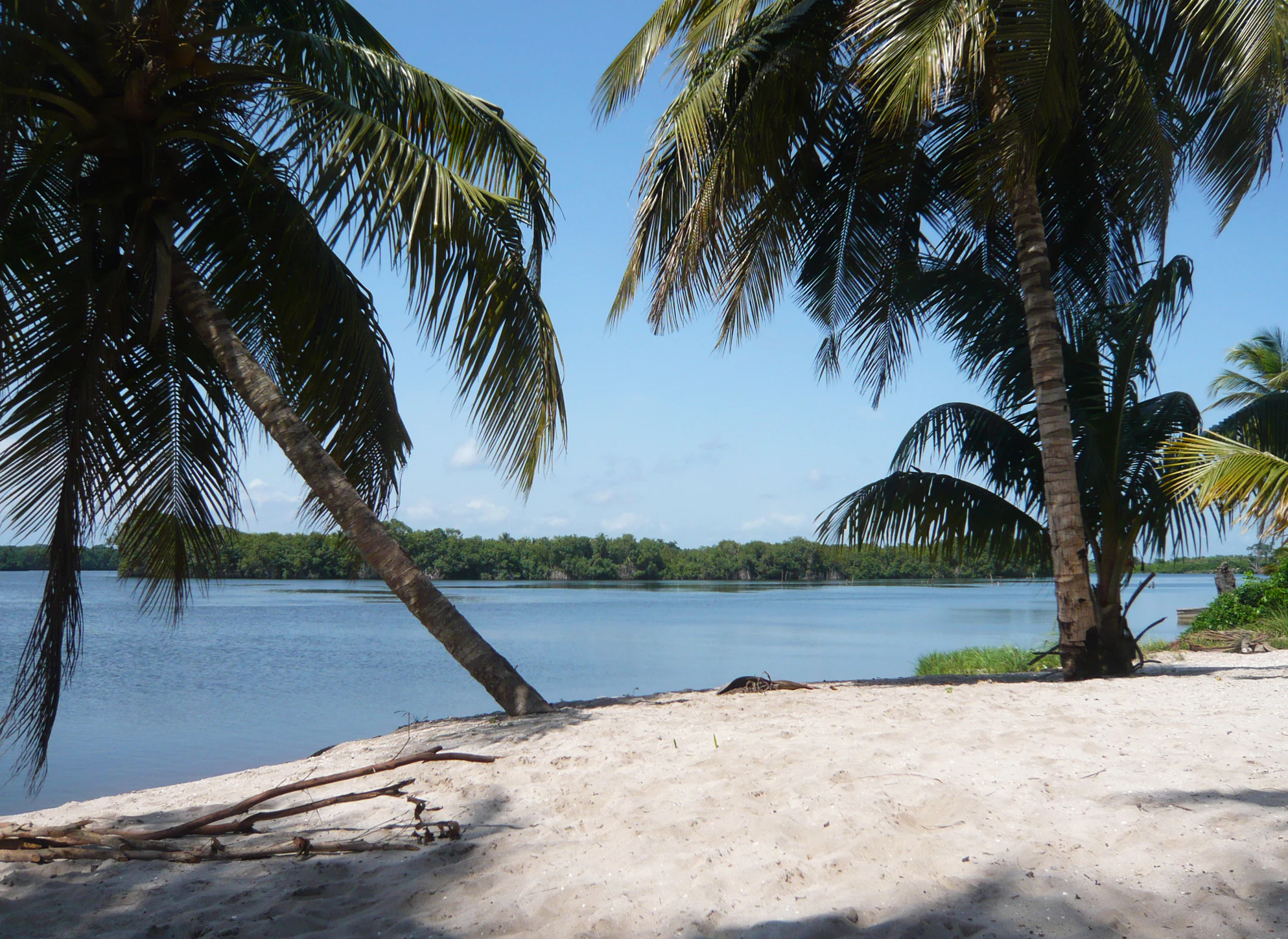
A sandy shoreline with palm trees in the foreground, overlooking the calm waters of a lagoon with a distant forested island.
A scenic view of the Aby Lagoon at Parc national des îles Ehotilé, framed by coastal palm trees.

Parc national des Iles Ehotile history and protected-area timeline

The Iles Ehotile were formally constituted as a national park by decree No. 074-179 on 25 April 1974. The designation came at the initiative of local communities, giving the park an unusually strong foundation in local stewardship rather than purely top-down government action.

In 2005, the site gained additional international recognition when it was added to the list of Ramsar Wetlands of International Importance, acknowledging the ecological value of its lagoons, channels, and island habitats. The park has also been included on UNESCO's tentative list of world heritage sites, reflecting the broader cultural and natural significance attributed to the archipelago by both national and international bodies.

Parc national des Iles Ehotile landscape and geographic character

The landscape of the park is dominated by water rather than by terrestrial terrain. The Aby lagoon complex and its surrounding channels form a vast estuarine environment where freshwater outflows meet coastal salinity. Within this watery matrix, the six islands of the Ehotile archipelago rise as patches of forest and shoreline vegetation, separated by intricate networks of channels, tidal flats, and mangrove stands.

Five of the islands occupy the strictly estuarine zone near the mouth of the lagoon, creating together a small island delta where sedimentation, tidal flow, and plant colonization shape the land. The island of Bosson Assoun, by contrast, lies in a quieter, more brackish zone further inland, near the boundary between the Ebrie and Tendo lagoon systems. The total land area of the archipelago is modest, but the surrounding lagoon channels, which are themselves part of the protected setting, give the park a broad and visually rich aquatic landscape.

Parc national des Iles Ehotile ecosystems, habitats, and plant life

Ecologically, the park sits at the meeting point of estuarine, lagoon, mangrove, and lowland forest environments. The result is a mosaic of habitats unusually compressed into a small geographic footprint. Mangroves fringe much of the shoreline, while the interior of the islands retains patches of forest that connect ecologically to the broader Ivorian coastal forest landscape. The brackish and saline gradients between the estuary and the inner lagoon create localized differences in salinity, vegetation, and wildlife use.

This combination of habitats makes the archipelago disproportionately important for biodiversity relative to its size. Aquatic and semi-aquatic species find refuge across the various lagoon zones, forest interiors provide roosting and nesting habitat, and the transition between freshwater, brackish, and marine influences sustains a complex trophic web that supports both resident and migratory fauna.

Parc national des Iles Ehotile wildlife and species highlights

Birdlife is one of the park's most visible wildlife features. Around 128 bird species have been recorded across roughly 35 families, dominated by aquatic species that depend on the lagoon and estuarine habitats. In the dry season, the islands receive additional migratory species, increasing the ornithological interest of the site on a seasonal basis.

The park also shelters terrestrial mammals typical of West African coastal forests, notably duikers and bushpigs, which retain a presence on the islands despite their proximity to human settlement. Two fauna stand out as particularly标志性 of the site: a notable colony of straw-coloured fruit bats (Roussettes des palmiers) that roosts on Balouate island, and the presence of the West African manatee in the surrounding lagoon waters. The manatee, in particular, is regarded as a representative species of Ivorian lagoons and is considered threatened, lending the park a particular conservation significance for aquatic mammals.

Parc national des Iles Ehotile conservation status and protection priorities

The park's conservation profile rests on its wetland character and the international recognition attached to it. Designated a national park in 1974, it received Ramsar Wetland status in 2005, formally placing it among internationally important wetland sites. Its broader inclusion within the Aby lagoon system adds to its conservation weight, since lagoons in this region are increasingly under pressure from coastal development, fishing pressure, and habitat change.

The archipelago's biodiversity value is unusually concentrated for its size: mangrove, estuarine, and island forest habitats co-exist within a small area, supporting vulnerable species such as the manatee and large bat colonies. The park therefore matters not only as a local protected area but also as a refuge for lagoon and estuarine species whose habitats have been shrinking elsewhere along the Ivorian coast.

Parc national des Iles Ehotile cultural meaning and human context

The park is closely bound up with the identity of local communities, particularly the Ehotile and, to a lesser extent, the Essouma peoples, both of whom claim cultural paternity over the islands. The surrounding riverside population is organized around 21 villages and is officially estimated at around 32,000 inhabitants, representing a significant share of the department's total population. Fishing is the dominant economic activity, reflecting the deep relationship between local livelihoods and the lagoon.

Several of the islands carry strong spiritual meaning. Bosson Assoun is regarded as a sacred island, while the straw-coloured fruit bat colony on Balouate is interpreted by local communities as a symbolic presence of deceased relatives. The chief town of the Ehotile canton is Etueboue, while the Essouma chiefdom is based in Assinie, and the park thus sits within a layered political and cultural landscape as well as a natural one.

Top sights and standout views in Parc national des Iles Ehotile

The defining highlights of the park are its six-island archipelago architecture, its estuarine lagoon setting within the Aby system, and the unusually rich mix of mangrove, forest, and aquatic habitats that the islands sustain. The presence of both Ramsar recognition and a UNESCO tentative listing signals that the park is regarded as significant well beyond Cote d'Ivoire's borders.

Distinctive highlights include the five-island estuarine cluster forming a lagoon delta near the mouth of the Aby complex, the sacred Bosson Assoun island in the inner lagoon, the diverse birdlife with both resident aquatic species and dry-season migrants, and the two especially characteristic animal groups: the straw-coloured fruit bats of Balouate and the lagoon-dwelling manatee.

Best time to visit Parc national des Iles Ehotile

Given the park's combination of lagoon, estuarine, and island forest habitats, the timing of a visit shapes both the experience and the wildlife opportunities. The dry season is particularly relevant for birdwatching, as migratory species join the resident aquatic birds around the islands and the lagoon waters. This period also tends to offer calmer conditions for exploring the archipelago and its channels.

During wetter periods, water levels rise and the lagoon system expands, intensifying the sense of an amphibious landscape; however, access conditions may also become more challenging. Travellers interested in bird diversity, lagoon scenery, and the cultural rhythm of riverside villages will generally find the drier months the most rewarding window for engaging with the park.

Monthly climate preview

Long-term representative temperature and precipitation rhythms across the coordinate

Parc national des îles Ehotilé Climate Normals and Monthly Weather Patterns

Representative coordinates record steady thermal averages alongside distinct monthly precipitation shifts throughout the year at Parc national des îles Ehotilé. Examining the complete twelve-month profile provides deeper clarity on long-term temperature ranges and precipitation normals.
Annual mean26 °C
24 °C28 °C
Jan27°
Feb28°
Mar28°
Apr28°
May27°
Jun26°
Jul25°
Aug24°
Sep25°
Oct26°
Nov27°
Dec27°
Warmest month
March

27.7 °C

Coolest month
August

24.3 °C

Wettest month
June

9.2 mm/day

Driest month
January

1.3 mm/day

Park location guide

Geography guide, regional context, and park location map for Parc national des Iles Ehotile

Parc national des Iles Ehotile park geography, regions, and map view in Ivory Coast

Understand where Parc national des Iles Ehotile sits in Ivory Coast through a broader geographic reading of the surrounding landscape, nearby location context, and its mapped position within the national park landscape.

How Parc national des Iles Ehotile fits into Ivory Coast

Ivory Coast, officially the Republic of Côte d'Ivoire, is a West African country with a coastline on the Gulf of Guinea. It gained independence from France in 1960 and is now a presidential republic. The country is a major producer of cocoa and coffee, with Abidjan serving as its largest city and economic hub, while Yamoussoukro is the official capital.

Wider geography shaping Parc national des Iles Ehotile in Ivory Coast

Ivory Coast is situated on the southern coast of West Africa along the Gulf of Guinea. It borders Guinea to the northwest, Liberia to the west, Mali to the northwest, Burkina Faso to the northeast, Ghana to the east, and the Atlantic Ocean to the south. The terrain includes coastal plains, interior highlands, and forested regions.

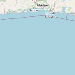
Map view of Parc national des Iles Ehotile

Use this park location map to pinpoint Parc national des Iles Ehotile in Ivory Coast, understand its exact geographic position, and read its mapped placement within the surrounding landscape more clearly.

Pigeon | © OpenStreetMap contributors

Location context for Parc national des Iles Ehotile

Comoé District

Explore photographic records of the lagoon archipelago, mangrove channels, and wetland environments.

Visualizing Parc national des îles Ehotilé: Landscapes, Scenery, and Protected Habitats

Visual documentation provides essential context for understanding the estuarine channels, mangrove fringes, and forested islands defining Parc national des îles Ehotilé. Photographic records reveal the complex terrain of the Aby lagoon archipelago and the diverse habitats sustaining regional wildlife.

A sandy shoreline with palm trees in the foreground, overlooking the calm waters of a lagoon with a distant forested island.

Park atlas

Compare surrounding regional geography and connected coastal wetland reserves

Other Parks Like Parc national des îles Ehotilé and Nearby Protected Areas

Browsing other parks near Parc national des îles Ehotilé provides valuable context on regional estuarine habitats and coastal conservation zones. Expanding the search reveals broader patterns across protected landscapes and interconnected lagoon environments.
National parkIvory Coast
About 0.8 km away#1 closest

Northwest

Îles Ehotilé National Park: A Protected Island Ecosystem within Ivory Coast's National Park Network

Explore its island terrain and mapped coastal geography.

Îles Ehotilé National Park stands as a protected island ecosystem within the national park system of Ivory Coast. This area is distinguished by its island landscapes, coastal zones, and the surrounding marine environments characteristic of the Gulf of Guinea. As a designated national park, it plays a crucial role in preserving unique West African island biodiversity and providing a mapped protected area for ecological study and appreciation. The park's conservation focus highlights the importance of safeguarding coastal habitats within the region.

Area
105 km²
Established
1974
IUCN
II
Relief
Lowland
National parkGhana
About 74 km away#2 closest

East

Nini-Suhien National Park: Protected Coastal Forest Geography and Mapping in Ghana

Regional forest landscapes and conservation boundaries

Nini-Suhien National Park serves as a vital anchor for coastal forest conservation in southwestern Ghana. This profile provides an atlas-level understanding of the park's location, its physical landscape features, and its role within the larger Ankasa Conservation Area for researchers and geography enthusiasts.

Area
160 km²
Established
1976
IUCN
II
Relief
Lowland
National parkGhana
About 74 km away#3 closest

East

Nini-Suhien National Park: Geographic Atlas and Protected Area Boundary Mapping

Regional landscape context and protected terrain in Ghana.

Nini-Suhien National Park serves as a crucial protected area within the geography of Ghana. This entry provides structured information regarding the park boundaries and regional landscape characteristics, facilitating a deeper understanding of its place in the broader West African natural landscape and mapping framework.

IUCN
II
Nature reserveWestern North Region
About 75 km away#4 closest

Northeast

Boin Tano Forest Reserve: Mapping Ghana's Protected Tropical Nature Reserve Landscapes

Regional geography and habitat analysis in Western North Region

Boin Tano Forest Reserve stands as a vital protected area in Ghana, recognized for its complex mosaic of equatorial forest, grassland, and shrubland. This 129 square kilometre reserve serves as a sanctuary for diverse primate, antelope, and bird populations, reflecting the rich biodiversity of the Upper Guinean forest ecosystem within the Western North Region.

Area
129 km²
Established
1968
IUCN
V
Relief
Lowland
National parkAbidjan
About 91 km away#5 closest

West

Banco National Park National Park: Primary Forest Landscape and Abidjan Geography

Explore mapped boundaries and urban conservation.

Banco National Park is a globally significant protected area, uniquely preserving dense primary tropical forest within the urban sprawl of Abidjan, Ivory Coast. This national park offers critical insights into urban conservation, featuring rare tree species and providing essential ecosystem services like water supply and carbon sequestration for the surrounding region. Its landscape, characterized by the Gbangbo River and rare mahogany and avodire trees, forms a vital geographic element within the metropolitan atlas.

Area
30 km²
Established
1953
IUCN
II
Relief
Lowland
A horizontal watercolor painting showing a green landscape with trees, a winding stream, and rolling hills in the background against a soft, light-filled sky.
National parkAbidjan
About 91 km away#6 closest

West

Parc national du Banco: Protected Tropical Rainforest and Urban Water Reserve in Abidjan

A dense primary forest island within a major urban landscape

Parc national du Banco preserves a significant block of primary tropical vegetation in the center of Abidjan. Functioning as both a vital municipal water reservoir and a complex wildlife refuge, this protected area offers a unique intersection of tropical forest ecology and dense urban development. Its central core of rare hardwood species and distinct river corridors illustrate a rare conservation landscape surrounded by the growth of a major West African metropolis.

Area
34.4 km²
Established
1953
IUCN
II
Relief
Lowland
National parkWestern North Region
About 101 km away#7 closest

North

Bia National Park: Ghana's Vital Protected Forest Landscape with West Africa's Tallest Trees

Explore the unique mapped geography and biodiversity of this key conservation area.

Bia National Park serves as a crucial protected landscape in Ghana's Western North Region, celebrated for harboring some of West Africa's tallest trees and a rich diversity of wildlife. This detailed entry provides context on its mapped boundaries and ecological significance as one of the last relatively untouched forest remnants in the region. Understand the park's place within Ghana's geography and its value for conservation research, showcasing its unique transitional forest ecosystem and the documented species it protects.

Area
563 km²
Established
1974
IUCN
II
Climate
Tropical
Protected landscapeWestern Region
About 108 km away#8 closest

Northeast

Mamiri Forest Reserve: Mapped Geography and Protected Landscape Identity in Western Ghana

Ecological transition zone of the Upper Guinea forest block

Spanning roughly 45 square kilometers, Mamiri Forest Reserve is defined by its unusual, elongated geometry and dissected hill-and-valley topography. This protected landscape serves as a vital transition zone between wet and moist evergreen forest types, supporting a complex array of seasonal wetland patches and upland forest ridges. Recognized for its significance as an Important Bird Area, it remains a critical remnant of the original high forest system found in this part of Ghana.

Area
45 km²
Established
1949
IUCN
V
Relief
Upland

Common questions about visiting, size, designation, and location context for Parc national des Iles Ehotile

Parc national des Iles Ehotile FAQs for park facts, access, geography, and protected area context

Find quick answers about Parc national des Iles Ehotile, including protected-area facts, park geography, trail and visitor context, and how the park fits into its surrounding country and regional landscape.
MoriAtlas Explorer

Continue Your Protected Areas Search Across the Global Atlas

Deepen your exploration by continuing the structured search for national parks and protected areas worldwide. Utilize the comprehensive filtering capabilities to compare different conservation landscapes and refine your understanding of global park geography. Discover more about the distribution and characteristics of protected natural areas.

Global natural geography