
Rivers
Park geography
Technical data on landscape extent, lowland terrain, and riverine features.
El Impenetrable National Park: Geographic Profile, Boundary Dimensions, and Regional Mapping
Analyze the physical scope and environmental characteristics of El Impenetrable National Park across Argentina. This profile provides data on its 1,289 square kilometer footprint, regional reach within the Chaco and Formosa provinces, and the presence of the Río Bermejo within its borders. Discover the mapped boundaries and lowland terrain patterns defining this subtropical protected area.
Related tags
Gran ChacoNational ParkArgentinaWildlife ConservationJaguar Habitat
Argentina's premier Chaco wilderness park protecting one of South America's last great dry forests
El Impenetrable National Park
El Impenetrable National Park is a vast protected area in the Gran Chaco region of northern Argentina, spanning portions of Chaco Province and Formosa Province. Established in 2014 through national law 26996 and opened to visitors in 2017, the park encompasses approximately 128,900 hectares, making it the largest natural park in northern Argentina. The park protects a representative sample of the Western Chaco ecosystem, one of South America's most extensive and ecologically significant dry forest biomes. The landscape features a complex interplay of ancient river channels, gallery forests along watercourses, savanna grasslands, and ephemeral wetlands that support remarkable biodiversity. The park's creation was the result of a lengthy conservation campaign following the tragic murder of the estate's owner in 2011, which brought international attention to the area's ecological value and the need for formal protection.
- Location
- Argentina
- Park type
- National park
- Established
- 2014
- Area
- 1,289 km²
Location overview
Regional provincial placement and transboundary conservation status
Geographic Setting of El Impenetrable National Park in Argentina
El Impenetrable National Park is situated in Argentina, spanning Chaco Province and Formosa Province. The conservation landscape holds recognized transboundary status across regional borders.
- Countries
- Argentina
- Regions
- Chaco Province, Formosa Province
- Primary location
- Argentina
- Geographic setting
- Transboundary · Inland
Boundary and coordinates
Geographic coordinates and spatial extent of 1,289 square kilometers.
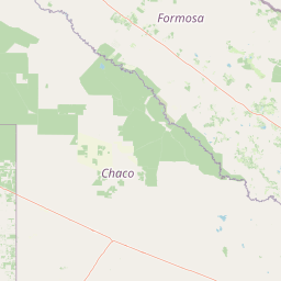
El Impenetrable National Park Geographic Boundary Map and Spatial Limits
Interactive map visualization shows the precise spatial layout of the protected terrain. Detailed geographic attributes define the total land area of 1,289 square kilometers alongside calculated coordinate span limits.
- Boundary area
- 1,293.2 km²
- Boundary perimeter
- 255 km
- Northernmost point
- 24.7429° S
- Southernmost point
- 25.2631° S
- Easternmost point
- 60.8202° W
- Westernmost point
- 61.3781° W
- Geographic centre
- 25.0034° S, 61.1046° W
- North–south span
- 57.6 km
- East–west span
- 56.3 km
Terrain and natural features
Lowland protected terrain and associated river systems
El Impenetrable National Park Terrain and Named Natural Features
Protected lowland terrain classifications define the regional landscape profile alongside recorded river networks. Linked feature cards supply official names, types, measurements, and spatial relationships within the boundary.
Selected named natural features
Environmental setting
Subtropical lowland terrain, forest cover, and diverse habitat classifications
El Impenetrable National Park Environmental Settings and Landscape Classifications
Stored classifications provide structured insight into subtropical lowland terrain, forest cover, and diverse habitat types across the protected area. Recorded categories connect directly to relevant atlas destinations to support detailed geographic exploration.
- Relief
- Lowland
- Climate
- Subtropical
- Water
- Minor water
- Forest cover
- Partial forest
- Seasonality
- Year-round
Landscape features
Forest · Grassland
Habitat types
Temperate broadleaf forest · Grassland · Savanna · Wetland · Riverine habitat
Park atlas
Map the Gran Chaco's protected landscapes, comparing other national parks and conservation areas in Argentina.
Discover Other National Parks and Protected Areas Near El Impenetrable National Park
Browse a curated list of national parks and protected areas near El Impenetrable National Park, focusing on the surrounding Gran Chaco region. Compare similar dry forest ecosystems and understand the broader geographic context of conservation efforts in northern Argentina's protected landscapes.
National parkSantiago del Estero Province
77 km away#1 closest
Southwest

Copo National Park: A Vital Dry Chaco Protected Landscape in Argentina
Explore its mapped boundaries and endemic forest ecosystems.
Copo National Park represents a significant conservation effort within Santiago del Estero Province, protecting a representative segment of the Dry Chaco biome. This national park preserves the iconic quebracho scrubland, a habitat that has been drastically reduced province-wide, serving as a critical refuge for endangered species like the jaguar and maned wolf. The park's landscape features warm climate conditions and characteristic forest formations dominated by the Santiago red quebracho, offering a unique opportunity to study and appreciate a vital, yet vulnerable, regional ecosystem. Its protected status underscores its importance for understanding Argentine protected areas and landscape ecology.
- Area
- 1,181.18 km²
- Established
- 2000
- IUCN
- II
- Relief
- Lowland
National parkChaco Province
214 km away#2 closest
Southeast
Chaco National Park: Protected Landscape and Regional Geography Atlas
Explore mapped boundaries within the Eastern Chaco's unique ecosystem.
Chaco National Park is an important protected area in Chaco Province, Argentina, dedicated to preserving the unique Eastern Chaco ecosystem. Covering 150 square kilometers, its landscape comprises warm lowland terrain with scrubland, savanna, swamp areas, and scattered lakes. This national park is recognized for its efforts to conserve the distinctive quebracho forests and supports a rich array of wildlife, making it a key site for understanding regional protected-area geography and landscape context.
- Area
- 150 km²
- Established
- 1954
- IUCN
- II
- Relief
- Lowland
National parkFormosa Province
252 km away#3 closest
East
Río Pilcomayo National Park: Protected Humid Chaco Wetland Landscape & Geography
Explore mapped boundaries and unique floodplain terrain in Formosa Province.
Río Pilcomayo National Park represents a significant protected natural area within Argentina's Formosa Province, characterized by the unique ecosystems of the Humid Chaco. The park's landscape is defined by extensive floodplains, marshes, lakes, and forests, all influenced by the Pilcomayo River's dynamic hydrological cycle. As a Ramsar site, it safeguards crucial habitats, including those for the endangered jaguar, and showcases iconic Caranday palm savannas. This detailed atlas entry provides insights into its mapped geography and the vital protected landscape it preserves.
- Area
- 518.89 km²
- Established
- 1951
- IUCN
- II
- Relief
- Lowland
National parkSalta Province
317 km away#4 closest
West
El Rey National Park: Protected Landscape and Geographic Atlas Exploration
Mapped boundaries and regional context within Salta Province.
Gain insight into El Rey National Park, a designated national park offering a distinct protected landscape within Argentina. This entry focuses on its mapped geographic presence and its role in the regional context of Salta Province. Understanding El Rey National Park through its terrain and protected status provides a foundational element for exploring South American natural areas within a structured atlas framework.
- Area
- 441.62 km²
- IUCN
- II
- Relief
- Mountain
- Scope
- Terrestrial
National parkParaguay
About 354 km away#5 closest
East

Ypoá National Park: Paraguay's Protected Wetland Landscape and Lake Ecosystem
Explore mapped boundaries and significant bird habitats in the Ñeembucú region.
Ypoá National Park is a critical protected area in Paraguay, renowned for its extensive wetland ecosystems dominated by Lake Ypoá. This national park encompasses a rich mosaic of marshlands, riparian forests, and aquatic vegetation, making it a significant habitat for numerous bird species, including several rare and endemic types. Its designation as a Ramsar Wetland underscores its ecological importance, offering a unique lens for understanding landscape context and protected-area geography within South America.
- Area
- 1,000 km²
- Established
- 1992
- IUCN
- II
- Relief
- Lowland
National parkArgentina
355 km away#6 closest
West
Calilegua National Park: Mapped Protected Landscape in Argentinian Geography
Explore the national park's boundaries and regional terrain.
Calilegua National Park represents a vital protected landscape within Argentina's extensive geography. This detail page provides an atlas-focused view, highlighting the park's specific geographic setting and its importance as a national park. Understand its mapped terrain and how it fits within the broader conservation context of South America. This resource is crafted for in-depth geographic discovery and map-based analysis of the park's protected area features.
- Area
- 763.06 km²
- Established
- 1979
- IUCN
- II
- Relief
- Mountain
Nature reserveDepartamento de Tarija
About 370 km away#7 closest
North

Reserva natural El Corbalán: Gran Chaco Protected Landscape and Regional Geography
A private nature reserve in Tarija Department, Bolivia.
Spanning the dry plains of the Chaco Boreal, Reserva natural El Corbalán provides essential protection for a representative sample of South American dry forest. The terrain, characterized by sparse thorny woodlands and flat lowland scrub, serves as a crucial habitat refuge. This resource offers insights into the unique ecological structure and mapped boundaries of one of Bolivia's most significant private conservation initiatives.
- Area
- 47.78 km²
- Established
- 1996
- Relief
- Lowland
- Water
- Minor water
National parkArgentina
411 km away#8 closest
Northwest
Baritú National Park National Park: Mapped Protected Landscapes in Argentina's Geography
Understand the natural terrain and geographic setting of this Argentinian park.
Baritú National Park represents a distinct national park entity within Argentina, crucial for understanding the country's protected landscapes and regional geography. This page provides specific atlas-level detail on its mapped boundaries and the surrounding natural terrain. Explore Baritú National Park as a key geographic feature contributing to the broader understanding of conservation areas across South America, grounded in factual, map-oriented discovery.
- Area
- 720 km²
- Established
- 1974
- IUCN
- II
- Relief
- Mountain
MoriAtlas Explorer
Continue Exploring El Impenetrable National Park's Protected Landscape and Geography
Deepen your understanding of El Impenetrable National Park by exploring its specific geographic features and protected landscape characteristics. Discover how its mapped boundaries contribute to Argentina's conservation atlas and regional natural context. This is your next step for detailed, factual park exploration.
Browse next
Global natural geography
Explore related park routes
Explore MoriAtlas Global ParksBrowse All MoriAtlas ParksGlobal Park Map DiscoveryMoriAtlas: Browse All CountriesBrowse All MoriAtlas ContinentsNational Park Environment AtlasGrand Canyon National Park AtlasYellowstone National Park AtlasYosemite National Park Atlas and GeographySerengeti National Park AtlasGalápagos National Park Protected LandscapeBanff National Park Geography and AtlasKruger National Park Atlas EntryUluṟu-Kata Tjuṯa National Park AtlasExplore Uluru-Kata Tjuta National Park GeographyPlitvice Lakes National Park AtlasFiordland National Park Protected LandscapeGreat Smoky Mountains National Park AtlasAfghanistan National Parks and Protected AreasAlbania National Parks and Protected AreasAlgeria National Parks and Protected AreasAmerican Samoa National Parks and Protected AreasAndorra National Parks and Protected AreasAngola National Parks and Protected AreasAntarctica National Parks and Protected AreasAntigua and Barbuda Park List