

Mori Atlas logo
National parkEl Impenetrable National Park

Explore the boundaries and regional context of this national park in Argentina.

El Impenetrable National Park: Argentina's Protected Landscape and Mapped Geography

(Parque Nacional El Impenetrable)

El Impenetrable National Park represents a significant protected natural area within Argentina, offering a unique geographic perspective. As a designated national park, it provides vital context for understanding the country's protected lands and regional terrain. This page serves as a gateway to exploring its mapped boundaries and its place within the broader South American atlas, highlighting the specific landscape identity it contributes to.

Gran ChacoNational ParkArgentinaWildlife ConservationJaguar HabitatDry Forest

El Impenetrable National Park

National park

Park overview

Structured park overview, official facts, and landscape profile for El Impenetrable National Park

El Impenetrable National Park park facts, protected area profile, and essential visitor context
Review the core facts for El Impenetrable National Park, including designation, size, terrain, visitor scale, habitats, and operating context in one park-focused overview.

About El Impenetrable National Park

El Impenetrable National Park represents one of Argentina's most significant recent additions to its national park system and stands as a testament to both the ecological importance of the Gran Chaco and the complex history of land conservation in South America. The park occupies a strategic position within the Bermejo River corridor, a critical corridor for wildlife movement across the continental Chaco ecosystem. The landscape is characterized by a diverse mosaic of habitats: gallery forests line the Bermejo and its tributaries, with their dense canopy providing refuge for arboreal species; ancient river channels known locally as cauces create linear wetlands that support aquatic life and attract wildlife during the dry season; and extensive savanna grasslands stretch across the interfluves, punctuated by clusters of thorny trees and large cacti. The park's establishment marked the culmination of over a decade of political and legal processes that began with the tragic events at Estancia La Fidelidad, the former cattle ranch that comprised most of the land now within the park boundaries. Today, the park offers visitors an authentic encounter with one of South America's least altered wilderness regions, where the sounds of the forest and the sight of large mammals moving through the landscape evoke an earlier era before extensive deforestation transformed much of the surrounding region.

Quick facts and research context for El Impenetrable National Park

El Impenetrable National Park covers 128,903 hectares in the Gran Chaco, straddling Chaco and Formosa provinces in northern Argentina. The park was formally established in 2014 and opened to the public in 2017, representing the largest protected area in Argentina's northern region. It sits within the Bermejo River basin, with varied terrain including river levees, former river channels, and seasonal wetlands. The area experiences a semi-tropical continental climate with high temperatures year-round and strongly seasonal rainfall concentrated between late spring and early autumn. The park protects critical habitat at the ecotone between semi-arid and humid Chaco ecosystems, supporting numerous threatened large mammal species.

Park context

Deeper park guide and search-rich context for El Impenetrable National Park

El Impenetrable National Park history, landscape, wildlife, and travel context
Explore El Impenetrable National Park through its history, landscape character, ecosystems, wildlife, conservation priorities, cultural context, and seasonal travel timing in a structured park guide built for atlas discovery and search intent.

Why El Impenetrable National Park stands out

El Impenetrable is best known for its exceptional population of large Neotropical mammals, particularly the yaguareté (the southern subspecies of jaguar), which has been the focus of an ambitious reintroduction and conservation program. The park protects one of the most significant remaining tracts of intact Chaco forest and serves as a stronghold for species that have been decimated across much of their range elsewhere in the Gran Chaco. The park is also notable for its dramatic conservation history, which included the expropriation of a massive private estate following a murder-for-land scheme, transforming what was once a working cattle ranch into a protected wilderness area. Visitors come to experience the quintessential Chaco landscape of dense thorn forest, open savannas, and seasonal water bodies that support extraordinary wildlife viewing opportunities.

El Impenetrable National Park history and protected-area timeline

The story of El Impenetrable National Park is intimately tied to the history of Estancia La Fidelidad, a 250,000-hectare cattle ranch that occupied much of what is now the protected area. The property was originally owned by Jorge Born and later acquired by Italian brothers Luis and Manuel Roseo in the 1970s. The ranch operated as a traditional extensiv ranching operation, though poor management decisions, including the release of 3,000 head of cattle without proper fencing, led to the establishment of a feral herd that persisted for decades. Following Luis Roseo's death in 1984, Manuel Roseo remained as the sole owner, maintaining the property despite accumulating debts and living modestly while operating a carpintería on-site. In January 2011, Manuel Roseo and his sister-in-law were brutally murdered in Juan José Castelli by a criminal group attempting to seize the valuable land, estimated at 250 million dollars. This murder brought intense scrutiny to the property and galvanized conservation efforts that had been building for years. The provincial government had already passed laws in 2007 and 2011 authorizing the expropriation of portions of the estate, and following the murder, accelerated the process of converting the land into a protected area. The national Congress passed law 26996 in October 2014, creating the national park, though legal challenges by heirs delayed formal possession until 2018. The park officially opened in August 2017, with its administrative headquarters located in Miraflores.

El Impenetrable National Park landscape and geographic character

The physical landscape of El Impenetrable reflects its position within the Bermejo-Bermejito (Teuco) river system, creating topographic and habitat diversity uncommon in many parts of the Gran Chaco. Near the rivers, elevated levees called albardones support gallery forests with richer soils and greater moisture, creating dense corridors of vegetation that contrast sharply with the surrounding thorn forest. The park contains numerous abandoned river channels, known locally as cauces, which form elongated depressions hosting tall grassland savannas that remain green well into the dry season. Seasonal rainfall collects in low-lying areas to form various water bodies, including Laguna El Breal and Pozo de los Yacarés, which become critical wildlife refuges during the dry months. The soils are predominantly alluvial in origin, with variable texture and limited development, featuring hydromorphic characteristics that influence vegetation patterns. The geomorphology creates a landscape of subtle but meaningful variation, with the rivers serving as the primary source of structural complexity and ecological diversity within the broader matrix of dry forest and savanna.

El Impenetrable National Park ecosystems, habitats, and plant life

The ecological character of El Impenetrable places it at a critical biogeographic crossroads, where elements of the semi-arid Western Chaco meet species and communities from the humid Eastern Chaco, creating a zone of exceptional biodiversity. The park lies within the Western Chaco ecoregion but receives influences from the Humid Chaco, resulting in a mixing of species from both biomes. The vegetation belongs to the Western Chaco district of the phytogeographic Chaco province, with characteristic species including vinal forests, quebracho woodlands (both white and red quebracho), palo santo, mistol, and an array of large cacti. Forest galleries along watercourses feature species such as aliso de río, sauce criollo, and palo amarillo, while the surrounding landscape supports the more typical xerophytic Chaco forest with its dense, spiny canopy. The climate presents significant challenges to wildlife, with temperatures that can exceed 40°C and occasionally reach 45°C in summer, while winter nights can drop below 5°C, creating seasonal extremes that have shaped the adaptations of the resident fauna.

El Impenetrable National Park wildlife and species highlights

El Impenetrable harbors an extraordinary concentration of large Neotropical mammals, many of which are threatened or endangered across their range. The park supports viable populations of apex predators including the yaguareté (Panthera onca palustris), the southern jaguar subspecies, as well as puma and yaguarundí. The carnivore assemblage also includes smaller felids such as the gato montés (Geoffroy's cat) and ocelote. The park protects significant populations of the aguará-guazú (maned wolf), the largest canid in South America, as well as various fox species including the zorro pampa and zorro de monte. Peccaries are well represented with three species present: collared peccary, white-lipped peccary, and the endangered Chaco peccary (or quimilero). The park also supports populations of tapir, both red and gray brocket deer, giant anteater, southern tamandua, and the iconic armadillo species including the giant armadillo (tatú carreta). The bird fauna includes at least 163 species, with notable species such as the crowned eagle (águila coronada), the Chaco parrot (loro hablador chaqueño), and the greater rhea (ñandú). Reptiles include both species of caiman found in Argentina, the yacaré ñato and yacaré overo, as well as various snake species including both boas and venomous pit vipers.

El Impenetrable National Park conservation status and protection priorities

El Impenetrable represents a cornerstone of conservation strategy for the Gran Chaco, one of South America's most threatened biomes. The park protects the largest remaining block of intact Chaco forest in northern Argentina and serves as critical habitat for species that have been eliminated from much of their historical range. The park is the focus of an ambitious yaguareté recovery program led by Fundación Rewilding Argentina (the organization founded by Douglas Tompkins) in collaboration with national and provincial environmental agencies. This program has involved the translocation and release of captive-bred jaguars, with individuals from the Iberá wetlands in Corrientes being introduced to establish a breeding population in the Chaco. Recent successes include documented wild births and the release of additional females to strengthen the population, which remains critically low. Conservation challenges include poaching pressure and the need to establish biological corridors connecting El Impenetrable to other protected areas, including Parque Provincial Fuerte Esperanza to the southwest and ultimately connecting south to Parque Nacional Copo in Santiago del Estero, creating a large conservation complex spanning hundreds of thousands of hectares.

El Impenetrable National Park cultural meaning and human context

The park region has been inhabited for centuries by indigenous communities, primarily the Wichi and Qom peoples, whose traditional lifestyles are deeply connected to the Chaco environment. These communities maintain presence within the boundaries of the protected area and participate in conservation efforts, reflecting the recognition that effective conservation in the Chaco must include respect for indigenous rights and traditional land use practices. The broader region also includes communities of criollo (descendants of Spanish colonists) who historically lived within what is now the park, and the expropriation process included provisions for relocating some of these residents to other areas. The park's name refers to the region's historical reputation as the Impenetrable, a reference to the dense, thorny vegetation that made travel and settlement difficult, a characteristic that also preserved the forest's integrity despite surrounding development.

Top sights and standout views in El Impenetrable National Park

The defining highlight of El Impenetrable is its exceptional wildlife viewing potential, particularly for large Neotropical mammals that have become rare across much of the continent. The yaguareté population, while still small, represents one of the most significant conservation opportunities in the region, with recent wild births offering hope for population recovery. The park's landscape diversity, from gallery forests along the Bermejo to seasonal savannas and wetlands, creates varied habitats that support over 160 bird species and dozens of mammal species. The opportunity to see caimans at Pozo de los Yacarés, where nearly a hundred individuals gather during the dry season, offers one of the most reliable wildlife viewing experiences in the Argentine Chaco. The park's recent establishment means much of the landscape retains a relatively pristine character, with large tracts of unaltered forest providing habitat for species that require extensive territories and minimal human disturbance.

Best time to visit El Impenetrable National Park

The optimal time to visit El Imetrable depends on what visitors hope to experience, with each season offering distinct advantages. The dry winter months from May through September generally offer the best wildlife viewing, as animals concentrate around remaining water sources and vegetation is less dense, making movement through the landscape easier. However, winter nights can be cool and the landscape may appear more parched after months without rain. The wet season from November through March brings the landscape to life, with the forest becoming lush and green and many bird species actively nesting, though some roads may become difficult to pass and insects are more abundant. The shoulder seasons of October and April offer a balance, with moderate temperatures and reasonable wildlife visibility. Visitors should be prepared for the extreme heat that can occur in any season, with summer temperatures regularly exceeding 40°C and occasionally reaching 45°C, making early morning and late afternoon activities essential.

Park location guide

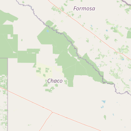
Geography guide, regional context, and park location map for El Impenetrable National Park

El Impenetrable National Park park geography, regions, and map view in Argentina
Understand where El Impenetrable National Park sits in Argentina through a broader geographic reading of the surrounding landscape, nearby location context, and its mapped position within the national park landscape.

How El Impenetrable National Park fits into Argentina

Argentina is a federal republic located in the southern cone of South America, bordering Chile, Bolivia, Paraguay, Brazil, Uruguay, and the Atlantic Ocean. With an area of 2,780,085 km², it is the second-largest country in South America and the eighth-largest globally. The capital and largest city is Buenos Aires, and the official language is Spanish. The country claims sovereignty over the Falkland Islands, South Georgia and the South Sandwich Islands, and a portion of Antarctica.

Wider geography shaping El Impenetrable National Park in Argentina

Argentina occupies the southern portion of South America, sharing the Southern Cone region with Chile to the west. The country borders Bolivia and Paraguay to the north, Brazil to the northeast, Uruguay and the South Atlantic Ocean to the east, and the Drake Passage to the south. The Andes mountain range runs along the western border, while the Pampas plains dominate the central region. Argentina also claims territories in Antarctica.

Map view of El Impenetrable National Park

Use this park location map to pinpoint El Impenetrable National Park in Argentina, understand its exact geographic position, and read its mapped placement within the surrounding landscape more clearly.

Pigeon | © OpenStreetMap contributors

Location context for El Impenetrable National Park

Chaco ProvinceFormosa Province
Park atlas

Map the Gran Chaco's protected landscapes, comparing other national parks and conservation areas in Argentina.

Discover Other National Parks and Protected Areas Near El Impenetrable National Park
Browse a curated list of national parks and protected areas near El Impenetrable National Park, focusing on the surrounding Gran Chaco region. Compare similar dry forest ecosystems and understand the broader geographic context of conservation efforts in northern Argentina's protected landscapes.
National parkSantiago del Estero Province

Copo National Park: A Vital Dry Chaco Protected Landscape in Argentina

Explore its mapped boundaries and endemic forest ecosystems.

Copo National Park represents a significant conservation effort within Santiago del Estero Province, protecting a representative segment of the Dry Chaco biome. This national park preserves the iconic quebracho scrubland, a habitat that has been drastically reduced province-wide, serving as a critical refuge for endangered species like the jaguar and maned wolf. The park's landscape features warm climate conditions and characteristic forest formations dominated by the Santiago red quebracho, offering a unique opportunity to study and appreciate a vital, yet vulnerable, regional ecosystem. Its protected status underscores its importance for understanding Argentine protected areas and landscape ecology.

Area
1,181.18 km²
Established
2000
IUCN
II
Relief
Lowland
National parkChaco Province

Chaco National Park: Protected Landscape and Regional Geography Atlas

Explore mapped boundaries within the Eastern Chaco's unique ecosystem.

Chaco National Park is an important protected area in Chaco Province, Argentina, dedicated to preserving the unique Eastern Chaco ecosystem. Covering 150 square kilometers, its landscape comprises warm lowland terrain with scrubland, savanna, swamp areas, and scattered lakes. This national park is recognized for its efforts to conserve the distinctive quebracho forests and supports a rich array of wildlife, making it a key site for understanding regional protected-area geography and landscape context.

Area
150 km²
Established
1954
IUCN
II
Relief
Lowland
National parkFormosa Province

Río Pilcomayo National Park: Protected Humid Chaco Wetland Landscape & Geography

Explore mapped boundaries and unique floodplain terrain in Formosa Province.

Río Pilcomayo National Park represents a significant protected natural area within Argentina's Formosa Province, characterized by the unique ecosystems of the Humid Chaco. The park's landscape is defined by extensive floodplains, marshes, lakes, and forests, all influenced by the Pilcomayo River's dynamic hydrological cycle. As a Ramsar site, it safeguards crucial habitats, including those for the endangered jaguar, and showcases iconic Caranday palm savannas. This detailed atlas entry provides insights into its mapped geography and the vital protected landscape it preserves.

Area
518.89 km²
Established
1951
IUCN
II
Relief
Lowland
National parkSalta Province

El Rey National Park: Protected Landscape and Geographic Atlas Exploration

Mapped boundaries and regional context within Salta Province.

Gain insight into El Rey National Park, a designated national park offering a distinct protected landscape within Argentina. This entry focuses on its mapped geographic presence and its role in the regional context of Salta Province. Understanding El Rey National Park through its terrain and protected status provides a foundational element for exploring South American natural areas within a structured atlas framework.

Area
441.62 km²
IUCN
II
Relief
Mountain
Scope
Terrestrial
National parkParaguay

Ypoá National Park: Paraguay's Protected Wetland Landscape and Lake Ecosystem

Explore mapped boundaries and significant bird habitats in the Ñeembucú region.

Ypoá National Park is a critical protected area in Paraguay, renowned for its extensive wetland ecosystems dominated by Lake Ypoá. This national park encompasses a rich mosaic of marshlands, riparian forests, and aquatic vegetation, making it a significant habitat for numerous bird species, including several rare and endemic types. Its designation as a Ramsar Wetland underscores its ecological importance, offering a unique lens for understanding landscape context and protected-area geography within South America.

Area
1,000 km²
Established
1992
IUCN
II
Relief
Lowland
National parkCorrientes Province

Mburucuyá National Park: National Park in Corrientes Province, Argentina

Iconic yatay palm savannas and diverse wetland ecosystems.

As a key national park within Argentina's Corrientes Province, Mburucuyá National Park offers a unique atlas-scale view of ecological convergence. It preserves expansive yatay palm savannas, critical wetland habitats within the Iberá Wetlands, and lush subtropical forests. The park's boundaries define an area where the Humid Chaco, Espinal, and Selva Paranaense biomes meet, creating a landscape of exceptional biodiversity and geographic significance for regional conservation and mapped exploration.

Area
176.82 km²
Established
2001
IUCN
II
Relief
Lowland
Protected areaGran Chaco Province

Aguaragüe National Park and Integrated Management Natural Area: Bolivia's Easternmost Sub-Andean Protected Landscape

Explore its mapped mountain geography and ecological diversity.

Aguaragüe National Park and Integrated Management Natural Area is a crucial protected area in Bolivia's Gran Chaco Province, defined by the Serranía del Aguaragüe mountain range. This landscape offers a unique opportunity to explore a geographic transition zone where Southern Andean Yungas montane forests converge with Dry Chaco ecosystems. The park's protected boundaries encompass a rugged mountain backbone rising from the lowlands, representing a vital segment of Bolivia's Sub-Andean geography and protected natural areas.

Area
1,083.07 km²
Established
2000
IUCN
II
Relief
Mountain
National parkArgentina

Baritú National Park National Park: Mapped Protected Landscapes in Argentina's Geography

Understand the natural terrain and geographic setting of this Argentinian park.

Baritú National Park represents a distinct national park entity within Argentina, crucial for understanding the country's protected landscapes and regional geography. This page provides specific atlas-level detail on its mapped boundaries and the surrounding natural terrain. Explore Baritú National Park as a key geographic feature contributing to the broader understanding of conservation areas across South America, grounded in factual, map-oriented discovery.

Area
720 km²
Established
1974
IUCN
II
Relief
Mountain

Common questions about visiting, size, designation, and location context for El Impenetrable National Park

El Impenetrable National Park FAQs for park facts, access, geography, and protected area context
Find quick answers about El Impenetrable National Park, including protected-area facts, park geography, trail and visitor context, and how the park fits into its surrounding country and regional landscape.
MoriAtlas Explorer

Continue Your Protected Areas Search Across the Global Atlas

Deepen your exploration by continuing the structured search for national parks and protected areas worldwide. Utilize the comprehensive filtering capabilities to compare different conservation landscapes and refine your understanding of global park geography. Discover more about the distribution and characteristics of protected natural areas.

Global natural geography
El Impenetrable National Park: Argentina National Park Map & Atlas
