

Mori Atlas logo
Protected areaEl Mogote

A striking sand barrier peninsula separating the Bay of La Paz from the Gulf of California.

El Mogote Protected Area: Mapping the Coastal Dune and Mangrove Landscapes of Baja California Sur

El Mogote serves as a critical geographic marker within Baja California Sur, forming a narrow sand barrier peninsula that bridges desert terrain and estuarine life. The site features an abrupt transition between wind-sculpted dune fields facing the Gulf of California and dense, tide-dependent mangrove thickets along the inner Bay of La Paz. This protected landscape functions as an essential ecological buffer and nursery, offering a clear view into the complex interactions between coastal development and sensitive wetland conservation in Mexico.

coastal peninsulamangrovesdune landscapearid terrainRamsar wetlandBay of La Paz

El Mogote

Protected area

Park overview

Structured park overview, official facts, and landscape profile for El Mogote

El Mogote park facts, protected area profile, and essential visitor context

Review the core facts for El Mogote, including designation, size, terrain, visitor scale, habitats, and operating context in one park-focused overview.

About El Mogote

El Mogote sits just offshore of La Paz, the capital of Baja California Sur, and is one of the defining geographic features of the Bay of La Paz. The peninsula is a long, narrow strip of sand and sediment that has built up parallel to the mainland coast, creating a sheltered lagoon system between the peninsula's southern shore and the city of La Paz. This lagoon is calm, shallow, and warm, and it is fringed by one of the more ecologically productive mangrove complexes on the eastern side of the Baja California peninsula.

Physically, El Mogote reads as two very different landscapes joined by a single landform. On the seaward side and across much of its interior, the terrain is dry and exposed, modeled by wind into rolling dunes and sparse, salt-tolerant vegetation. On the bay-facing side, the tidal flats give way to thick stands of mangrove where the land meets quiet water. This juxtaposition of arid dunes and productive estuary within a few hundred meters is what gives the peninsula its distinctive character and ecological importance.

The mangroves of El Mogote have been formally recognized as a wetland of international importance under the Ramsar Convention, with the official designation "Humedales Mogote - Ensenada La Paz." The recognition reflects the mangroves' role in supporting biodiversity, sustaining local fisheries, protecting the coastline, and providing stopover habitat for migratory birds along the Pacific flyway. Beyond birds, the mangrove system serves as nursery grounds for various marine species that underpin traditional fishing in the region.

Alongside its ecological identity, El Mogote has a significant human story. The sheltered bay waters and mangrove ecosystem historically supported fishing and shellfish gathering by local communities, and the peninsula has long been tied to the livelihoods of people in La Paz. In the early twenty-first century, the eastern portion of El Mogote became the site of Paraíso del Mar, an ambitious resort project that drew attention not only for its scale but for the ecological and legal controversies that followed its construction. The development brought the peninsula into broader discussions about coastal development, mangrove protection, and the social value of these wetlands to nearby fishing communities.

Quick facts and research context for El Mogote

El Mogote is a sand barrier peninsula in Baja California Sur, Mexico, located opposite the city of La Paz and forming the northern boundary of the Bay of La Paz. The peninsula is predominantly arid, crossed by extensive dune fields in its narrow central sections, and fringed on its bay-facing shore by mangrove stands that support resident and migratory birds, nursery species, and coastal protection functions. Its mangroves are formally designated as the Ramsar site "Humedales Mogote - Ensenada La Paz," recognized in 2008 for their wetland significance. The eastern portion of El Mogote hosts Paraíso del Mar, a large resort project begun in 2005 that has faced ecological and legal challenges.

Protection and recognition

Documented conservation scope, designation year, and management framework

El Mogote Protection Status and Official Designation History

El Mogote maintains a documented mixed protection status established in the year 2008. Official conservation records outline the designated framework, management scope, and recognition history for this protected landscape.

Protection details

Protection scope
Mixed
Designated year
2008
Transboundary protection
No
Park context

Deeper park guide and search-rich context for El Mogote

El Mogote history, landscape, wildlife, and travel context

Explore El Mogote through its history, landscape character, ecosystems, wildlife, conservation priorities, cultural context, and seasonal travel timing in a structured park guide built for atlas discovery and search intent.

Why El Mogote stands out

El Mogote is best known for the mangrove ecosystems along its southern shore, which form one of the ecologically important coastal wetlands of the Bay of La Paz. These mangroves act as nurseries for marine species, nesting and feeding habitat for shorebirds and migratory birds, and a natural buffer against storms and coastal erosion. The peninsula is also recognized for its dramatic dune systems, where arid desert terrain meets sheltered estuarine waters, and for being one of the more visible case studies in Mexico of large-scale coastal development intersecting with protected mangrove habitat.
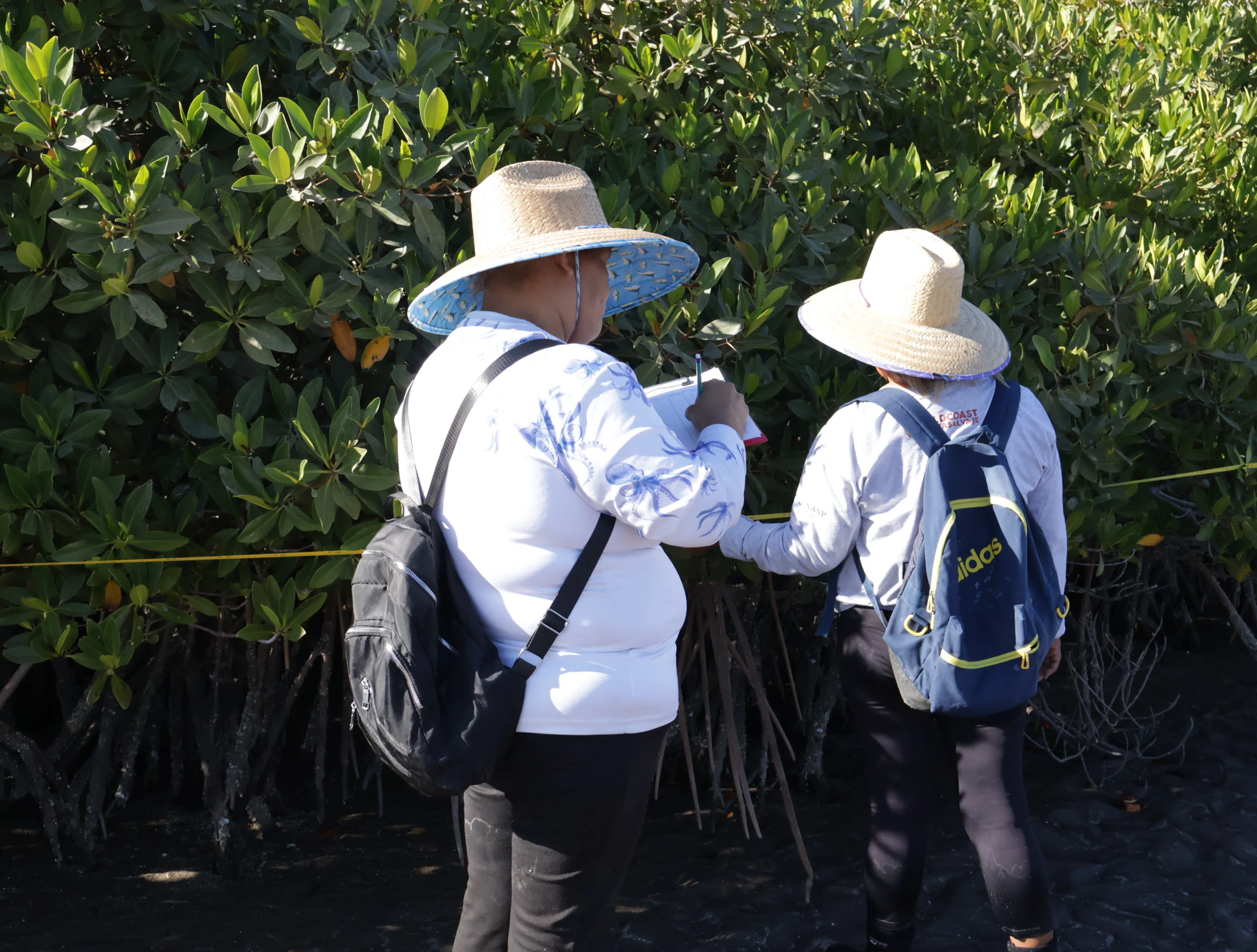
Guardians of Conchalito monitoring the Mogote mangrove
The Guardians of Conchalito monitoring the Mogote mangrove area

El Mogote history and protected-area timeline

El Mogote's deep history is tied to the Bay of La Paz and its surrounding human communities, which have long relied on the mangrove-rich waters for fishing, shellfish harvesting, and other traditional uses. The bay and its estuarine fringes have supported local livelihoods for generations, embedding the peninsula into the working cultural landscape of the La Paz region.

The modern history of El Mogote as a recognized natural site began with growing awareness of its mangrove ecosystems and their ecological importance in the late twentieth and early twenty-first centuries. In 2008, the wetlands were formally inscribed under the Ramsar Convention under the name "Humedales Mogote - Ensenada La Paz," marking international recognition of their value as habitat for migratory and resident birds and as nursery grounds for marine life.

A more contested chapter began in 2005, when construction started on Paraíso del Mar, a large resort and residential development on the eastern portion of the peninsula. The project envisioned thousands of homes, condominiums, golf courses, a marina, and supporting infrastructure. Its development proceeded despite environmental concerns about impacts on the peninsula's ecology and surrounding waters. In 2011, the original developer abandoned the project, and the following year the golf course's operations were halted. By the early 2010s, Mexican federal courts had ruled portions of the development illegal, ordering further construction to cease, while an association of existing owners continued to manage the built portions and the remaining golf course, later reopened as a public facility.

El Mogote landscape and geographic character

El Mogote is a long, narrow sand barrier peninsula that arcs across the northern edge of the Bay of La Paz. Its most defining visual contrast lies in the meeting of two very different environments: the arid, dune-driven seaward terrain and the sheltered, mangrove-fringed bay shoreline. Together they create a landscape where desert and estuary exist side by side.

The interior and outer flanks of the peninsula are characterized by aridity. Across the narrowest section of El Mogote, often referred to as the neck, wind-shaped dunes cover much of the surface, with sparse, salt- and drought-tolerant vegetation. These dune fields give the peninsula a sense of openness and exposure, with views across both the Gulf of California and the sheltered bay.

On the southern, bay-facing shore, the landscape changes abruptly. Here, tidal flats and shallow waters support dense mangrove stands. The transition from rolling dunes to quiet mangrove channels is one of the most visually distinctive features of the peninsula and contributes directly to its ecological character. The mangrove fringes not only shape the visual identity of the bay side but also influence how the lagoon functions, slowing water, trapping sediment, and sheltering juvenile marine species.

El Mogote ecosystems, habitats, and plant life

The ecological identity of El Mogote is defined by the interaction of its arid dune systems with its bay-facing mangrove wetlands. The mangrove ecosystems along the southern shore are high in productivity and biodiversity, acting as critical habitat for both resident and migratory species.

These mangrove stands function as nurseries for marine life, including commercially and ecologically important mollusks, crustaceans, and fish species that later disperse into the broader Gulf of California. They also provide feeding and resting habitat for shorebirds and waterbirds, including species such as the least tern, which is recognized under Mexican environmental protection standards. Beyond their habitat value, the mangroves help stabilize the shoreline, dampen storm impacts, and mitigate coastal erosion during hurricanes.

The arid dune sections of the peninsula, by contrast, support a more sparse but specialized suite of plant and animal life adapted to dry, salty conditions. Together, these contrasting ecosystems make El Mogote a compact but ecologically layered landscape, where desert and estuary coexist within a single narrow strip of land.

El Mogote wildlife and species highlights

Wildlife on El Mogote is shaped by the peninsula's two contrasting environments: the exposed arid dunes and the sheltered mangrove channels of the bay. The mangroves are the heart of the peninsula's fauna, supporting high densities of resident and migratory birds as well as the early life stages of many marine species.

Birdlife is one of the most visible elements of El Mogote's wildlife profile. The mangroves and tidal flats provide nesting, feeding, and roosting habitat, with the area forming part of an important network for migratory shorebirds moving along the Pacific flyway. The least tern, a species recognized under Mexican protection standards, has been documented using the mangrove area, highlighting the site value for sensitive birdlife.

Below the waterline and within the mangrove root systems, the wetlands serve as nursery habitat for a range of marine species, including juvenile fish, crustaceans, and mollusks. This makes the mangrove ecosystem important not only for biodiversity in its own right but also for sustaining the fisheries of the surrounding bay.

El Mogote conservation status and protection priorities

El Mogote's most significant conservation contribution lies in its mangrove wetlands, which were formally recognized as a Ramsar site of international importance in 2008 under the designation "Humedales Mogote - Ensenada La Paz." This recognition reflects the mangroves' role in supporting migratory birds, sustaining marine biodiversity, and protecting the La Paz coastline from erosion and storm damage.

Beyond their intrinsic ecological value, the mangroves provide important ecosystem services. They act as nurseries for fish and shellfish species that sustain local fisheries, help filter coastal waters, and stabilize sediments along the bay. Their protection under international convention places El Mogote among the more formally recognized wetland sites on Mexico's Pacific coast.

The peninsula has also become a notable case study in the challenges of balancing coastal development with mangrove conservation. The Paraíso del Mar project raised significant concerns about ecological impact and ultimately faced federal court rulings against further construction. Community engagement, including local fishing collectives and homeowner associations, has played a role in shaping the conservation landscape around El Mogote, with efforts aimed at sustaining the peninsula's ecological and social values alongside limited development.

El Mogote cultural meaning and human context

El Mogote is closely tied to the working cultural fabric of La Paz and the Bay of La Paz. Historically, the sheltered waters and mangrove-rich shoreline have supported fishing communities whose livelihoods depend on the peninsula's estuarine resources. Shellfish gathering, small-scale fishing, and other traditional uses have long connected local people to the rhythms of the bay.

Community organizations, including local fishing collectives and groups such as Las Guardianas del Conchalito that monitor mangrove conditions, reflect a continuing relationship between residents and the peninsula. The mangrove ecosystem is not only an ecological feature but a cultural and economic resource, woven into how coastal communities in the La Paz region understand and use their environment. The development controversies surrounding Paraíso del Mar also placed El Mogote into broader public conversations about how to reconcile tourism growth, real estate development, and the protection of traditional coastal ways of life.

Top sights and standout views in El Mogote

El Mogote's standout qualities lie in the meeting of arid dune landscapes with a mangrove-lined sheltered bay, all within a single sand barrier peninsula facing La Paz. Its mangroves, formally inscribed under the Ramsar Convention, are a defining feature, supporting migratory and resident birds, marine nursery species, and coastal protection functions.

The peninsula is also notable for the visibility of conservation and development tensions along its eastern portion, where the partially built Paraíso del Mar project has become a frequently cited case in discussions about coastal development, mangrove protection, and the relationship between tourism growth and traditional fishing livelihoods in Baja California Sur.

Best time to visit El Mogote

El Mogote's atmospheric character shifts with the seasons in ways typical of the southern Baja California Peninsula. The cooler, drier months from late autumn through early spring tend to bring calmer conditions, clearer skies, and comfortable temperatures for exploring the bay side of the peninsula and observing seabirds and shorebirds in the mangroves.

The warmer summer months bring higher humidity and the possibility of tropical storm activity in the Gulf of California region. Hurricane season can affect both water conditions and the sensitivity of the mangrove ecosystems, while also being a period when the bay's marine productivity is high. Wildlife viewing and mangrove exploration are generally rewarding across much of the year, with cooler months favored for broader outdoor comfort and warmer months offering rich marine encounters in the calm bay waters.

Monthly climate preview

Long-term representative point measurements tracking annual temperature and precipitation cycles

El Mogote Climate Normals and Measured Monthly Temperature Rhythms

Representative coordinates record annual temperature extremes spanning from 11.91 degrees Celsius up to 37.56 degrees Celsius alongside varying monthly precipitation rates. Detailed monthly data profiles track complete twelve-month weather patterns across the landscape.
Annual mean24 °C
19 °C29 °C
Jan19°
Feb20°
Mar21°
Apr22°
May23°
Jun26°
Jul28°
Aug29°
Sep29°
Oct27°
Nov23°
Dec20°
Warmest month
August

29.2 °C

Coolest month
January

19.2 °C

Wettest month
September

2.9 mm/day

Driest month
April

0 mm/day

Park location guide

Geography guide, regional context, and park location map for El Mogote

El Mogote park geography, regions, and map view in Mexico

Understand where El Mogote sits in Mexico through a broader geographic reading of the surrounding landscape, nearby location context, and its mapped position within the national park landscape.

How El Mogote fits into Mexico

Mexico, officially the United Mexican States, is a country in North America spanning the Sierra Madre mountain ranges, coastal plains, and tropical regions. It borders the United States to the north, Guatemala and Belize to the southeast, and has coastlines along the Pacific Ocean, Gulf of Mexico, and Caribbean Sea. With a population exceeding 130 million, Mexico is home to one of the world's most significant concentrations of Indigenous languages alongside Spanish.

Wider geography shaping El Mogote in Mexico

Mexico occupies a land area of 1,972,550 km2, making it the thirteenth-largest country in the world. The terrain is highly diverse, featuring the Sierra Madre Occidental and Sierra Madre Oriental mountain ranges, the Mexican Plateau, coastal lowlands along the Pacific and Gulf/Caribbean margins, and the Yucatan Peninsula. The country spans multiple climate zones from desert in the north to tropical rainforest in the south.

Map view of El Mogote

Use this park location map to pinpoint El Mogote in Mexico, understand its exact geographic position, and read its mapped placement within the surrounding landscape more clearly.

Pigeon | © OpenStreetMap contributors

Location context for El Mogote

Baja California Sur

Explore visual records of arid dune terrain and protected coastal mangrove habitats

El Mogote Photos and Landscape Scenery: Visualizing the Peninsula Environment

El Mogote photos capture the striking visual contrast between wind-swept sand dunes and dense mangrove estuaries along the Bay of La Paz. Examining these protected area views helps researchers understand coastal topography, habitat transitions, and regional park environments.

Guardians of Conchalito monitoring the Mogote mangrove

View of La Paz from El Mogote Mangrove

Park atlas

Compare surrounding coastal landscapes and nearby protected terrain.

Explore Protected Areas and Parks Near El Mogote in Regional Context

Browse other protected areas and national parks located near El Mogote to examine broader coastal geography. Comparing adjacent reserves helps place arid dune systems and mangrove wetlands within a wider regional network.
Wildlife reserveBaja California Sur
About 17 km away#1 closest

North

Área de protección de flora y fauna Balandra: Wildlife Reserve and Gulf Coast Geography

Protected mangrove lagoon landscapes in Baja California Sur

Discover the ecological significance of Área de protección de flora y fauna Balandra, a protected coastal area near La Paz. This site features a unique convergence of mangrove forests, shallow sandy bays, and arid desert coastal scrub that defines its status as a significant wildlife reserve in northwestern Mexico.

Area
25.125 km²
Established
2012
Relief
Lowland
Climate
Arid
Biosphere reserveBaja California Sur
About 33 km away#2 closest

Southeast

Sierra La Laguna Biosphere Reserve: Mapping the Highest Range in Baja California Sur

Highland geography and protected ecological terrain

Sierra La Laguna represents a singular protected landscape in Baja California Sur, characterized by high-elevation pine-oak forests and granite massifs. Its rugged topography and distinct microclimates support a dense concentration of endemic species while serving as the principal aquifer recharge zone for the southern peninsula region.

Area
1,124.37 km²
Established
1994
Relief
Mountain
Climate
Subtropical
National parkBaja California Sur
About 125 km away#3 closest

Southeast

Cabo Pulmo National Park: National Park Atlas and Protected Landscape Discovery

Explore its mapped geographic boundaries and regional context.

Cabo Pulmo National Park represents a vital protected natural landscape offering unique atlas exploration opportunities. Understand its specific geographic placement within Baja California Sur and explore its mapped boundaries as a national park. This destination provides a focused look at protected natural areas and their significance in regional geography.

Area
71.11 km²
Established
1995
IUCN
II
Relief
Lowland
National parkBaja California Sur
About 203 km away#4 closest

North

Bahía de Loreto National Park: National Park Protected Landscape and Geographic Identity

Explore its mapped boundaries and regional context.

Bahía de Loreto National Park offers a distinct focus on its protected natural landscape and geographic features within Baja California Sur. This destination provides detailed mapping and regional context, enabling a focused exploration of its boundaries and natural environment. It is ideal for users seeking to understand the specific protected area identity and its geographical placement as part of a broader atlas of conservation landscapes.

Area
2,065.81 km²
Established
1996
IUCN
II
Relief
Mixed relief
Regional parkSinaloa
About 350 km away#5 closest

East

Ceuta Regional Park: Coastal Geography and Protected Nesting Habitats in Sinaloa

Coastal protection and agricultural valley landscape analysis.

Ceuta Regional Park stands as a key protected area on the Sinaloa coast of Mexico, noted for its long-standing sea turtle conservation initiatives and importance to migratory shorebirds. The park geography spans low-lying coastal plains and beach environments, framed by the agricultural heart of the Elota municipality. This entry provides a structural overview of the terrain, boundaries, and ecological context defining this coastal reserve.

Area
15 km²
Established
2002
Relief
Lowland
Access
Access unknown
Protected areaSonora
About 368 km away#6 closest

Northeast

Área de protección de flora y fauna Sierra de Álamos-Río Cuchujaqui: Geography and Park Boundaries

Detailed atlas view of the Sonora biodiversity enclave and canyon systems.

Spanning over 92,000 hectares in Sonora, this protected area is defined by its dramatic transition from coastal plains to the Sierra Madre range. The geography centers on the deep, moisture-trapping barrancas of the Cuchujaqui River, which sustain a rare mixture of Neotropical and temperate species. Examine the structural complexity of these forested slopes and river-carved valleys that function as a essential habitat for large predators and diverse flora alike.

Area
928.9 km²
Established
1996
Wildlife reserveSinaloa
About 383 km away#7 closest

East

Meseta de Cacaxtla Flora and Fauna Protection Area: Sinaloa Protected Landscape Overview

Mapping dry forests and Pacific coastal ecosystems

Meseta de Cacaxtla Flora and Fauna Protection Area is a significant wildlife reserve in Sinaloa, characterized by its transition from an elevated inland plateau to a complex coastal fringe of mangroves and lagoons. Spanning 508 square kilometers, this protected area preserves an essential blend of arid tropical ecosystems and marine habitats along the Mexican Pacific coast, providing a clear geographic view of regional conservation efforts.

Area
508.62 km²
Established
2000
IUCN
VI
Relief
Lowland
Protected areaChihuahua
About 389 km away#8 closest

Northeast

Cerro Mohinora: Protected Volcanic Summit and Alpine Geography in Chihuahua

An analysis of volcanic terrain and high-elevation protected ecosystems.

Cerro Mohinora dominates the skyline as a prominent volcanic landmark within the Sierra Madre Occidental. This record details the protected area's geographic reach, examining its complex igneous history and the dramatic vertical transition from pine-covered slopes to its snowy summit, offering a clear map-oriented view of this significant Chihuahua natural landmark.

Established
2012
Relief
Mountain
Water
Minor water
Season
Seasonal

Common questions about visiting, size, designation, and location context for El Mogote

El Mogote FAQs for park facts, access, geography, and protected area context

Find quick answers about El Mogote, including protected-area facts, park geography, trail and visitor context, and how the park fits into its surrounding country and regional landscape.
MoriAtlas Explorer

Continue Your Protected Areas Search Across the Global Atlas

Deepen your exploration by continuing the structured search for national parks and protected areas worldwide. Utilize the comprehensive filtering capabilities to compare different conservation landscapes and refine your understanding of global park geography. Discover more about the distribution and characteristics of protected natural areas.

Global natural geography