Mori Atlas logo
Wildlife reserveEleanor Island

A strictly protected island refuge within the diverse lake landscape of the Canadian Shield

Eleanor Island Wildlife Reserve and Migratory Bird Sanctuary in Ontario Canada

(Eleanor Island Migratory Bird Sanctuary)

Eleanor Island Wildlife Reserve functions as a critical colonial waterbird nesting site situated in the southern basin of Lake Muskoka in Ontario. This protected area represents an essential part of the Canadian federal wildlife network, safeguarding habitat for species such as Great Blue Herons and Double-crested Cormorants. The sanctuary remains a significant example of concentrated conservation within the broader rocky terrain and forested islands of the Muskoka lake district.

migratory bird sanctuarycolonial waterbirdsisland sanctuaryLake MuskokaOntario provincial protected areaCanadian Shield

Eleanor Island

Wildlife reserve

Park overview

Structured park overview, official facts, and landscape profile for Eleanor Island Migratory Bird Sanctuary

Eleanor Island Migratory Bird Sanctuary park facts, protected area profile, and essential visitor context

Review the core facts for Eleanor Island Migratory Bird Sanctuary, including designation, size, terrain, visitor scale, habitats, and operating context in one park-focused overview.

About Eleanor Island Migratory Bird Sanctuary

Eleanor Island Migratory Bird Sanctuary is a small but carefully protected nature reserve in Ontario's Muskoka region, situated on Eleanor Island in the southern portion of Lake Muskoka. The sanctuary was established in 1978 under Canadian federal authority as part of the country's Migratory Bird Sanctuary program, a network of protected areas designed to safeguard breeding, staging, and migratory habitat for native birds.

The reserve covers only about 0.6 hectares, making it one of the smallest protected sites in the network. Despite its modest size, Eleanor Island carries significant conservation weight because it functions as a colonial waterbird breeding site. Great Blue Herons, Ring-billed Gulls, and Double-crested Cormorants have historically nested on the island, using its forested and shoreline habitats for colony-based reproduction. The overlap between the Migratory Bird Sanctuary and the Eleanor Island National Wildlife Area, also established in 1978, gives the island dual federal protection status.

Administratively, the sanctuary falls under the Canadian Wildlife Service, which manages it as an IUCN Category Ia strict nature reserve. This classification emphasizes ecological preservation and limits any form of access that could disturb wildlife. Public landing on Eleanor Island is prohibited, and the sanctuary is not designed for tourism or recreation. Its importance lies not in visitor amenities but in its quiet, consistent role of supporting breeding waterbirds in a region otherwise characterized by private cottages, boating, and seasonal lake activity.

The island sits within a landscape of glacially formed Canadian Shield terrain dotted with lakes, coniferous and mixed forests, and scattered islands. While the broader Muskoka region is famous for its recreational and resort character, Eleanor Island represents a small, deliberately protected refuge within that setting, where natural processes and breeding bird activity take precedence over human use.

Quick facts and research context for Eleanor Island Migratory Bird Sanctuary

Eleanor Island Migratory Bird Sanctuary is a federal bird sanctuary established in 1978 on Eleanor Island, a small island in southern Lake Muskoka, Ontario. The sanctuary covers roughly 0.6 hectares and is classified as an IUCN Category Ia strict nature reserve, emphasizing protection over public access. It overlaps with the Eleanor Island National Wildlife Area, also created in 1978, and is administered by the Canadian Wildlife Service.

The island lies about 1.7 kilometers from the mainland and is positioned between Gravenhurst and Bracebridge, near another small island known as Browning Island. Eleanor Island's protected status reflects its value as a colonial waterbird breeding site, with access to the island itself prohibited to reduce disturbance during the nesting season.

Protection and recognition

Analysis of terrestrial protected area designation and official records

Eleanor Island Protection Status and Documented Conservation Scope

Terrestrial conservation records for Eleanor Island outline documented protection status and official database references. Registry details provide structured baseline metrics for tracking international protected area classifications.

Protection details

Protection scope
Terrestrial
Transboundary protection
No
WDPA ID
555637951
Park context

Deeper park guide and search-rich context for Eleanor Island Migratory Bird Sanctuary

Eleanor Island Migratory Bird Sanctuary history, landscape, wildlife, and travel context

Explore Eleanor Island Migratory Bird Sanctuary through its history, landscape character, ecosystems, wildlife, conservation priorities, cultural context, and seasonal travel timing in a structured park guide built for atlas discovery and search intent.

Why Eleanor Island Migratory Bird Sanctuary stands out

Eleanor Island Migratory Bird Sanctuary is best known as a protected colonial waterbird breeding site on Lake Muskoka. The tiny Muskoka island hosts nesting Great Blue Herons, Ring-billed Gulls, and Double-crested Cormorants, making it a small but ecologically significant refuge within Ontario's lake country. The sanctuary's reputation also rests on its strict protection regime. Classified as an IUCN Category Ia strict nature reserve, it prohibits landings on the island, underscoring the priority given to minimizing human disturbance at active bird colonies. This combination of concentrated breeding value and strict access controls defines Eleanor Island's standing within Canada's Migratory Bird Sanctuary network.

Eleanor Island Migratory Bird Sanctuary history and protected-area timeline

Eleanor Island Migratory Bird Sanctuary was established in 1978 as part of Canada's federal Migratory Bird Sanctuary program. Its creation coincided with the establishment of the Eleanor Island National Wildlife Area in the same year, creating overlapping protection designations on the same small island.

The sanctuary was set up specifically to protect a colonial waterbird breeding site on Eleanor Island, where Great Blue Herons, Ring-billed Gulls, and Double-crested Cormorants were nesting. The choice of a strict protection model, eventually formalized as IUCN Category Ia, demonstrates the deliberate intent to limit human disturbance at the breeding colony. Since its establishment, the sanctuary has remained under the administration of the Canadian Wildlife Service and has continued to function primarily as a conservation reserve rather than a public-use area.

Eleanor Island Migratory Bird Sanctuary landscape and geographic character

Eleanor Island is a very small island in the southern basin of Lake Muskoka, one of the larger lakes in Ontario's Muskoka District. The lake itself sits within the Canadian Shield, a landscape shaped by ancient Precambrian rock and reshaped repeatedly by glacial activity, resulting in a terrain of rocky shorelines, forested islands, irregular coastlines, and clear freshwater.

The island lies close to the mainland shoreline, approximately 1.7 kilometers offshore, and is situated near the small community of Gravenhurst and the town of Bracebridge. Another small island, Browning Island, lies nearby in the same portion of the lake. Eleanor Island itself is only about 0.6 hectares in extent, a sliver of land that nonetheless supports enough vegetation structure to function as a nesting platform for colonial waterbirds. The surrounding lake setting is characterized by mixed coniferous and deciduous forest cover typical of the southern Canadian Shield.

Eleanor Island Migratory Bird Sanctuary ecosystems, habitats, and plant life

Eleanor Island's ecological value is rooted in its role as a breeding-ground refuge for colonial waterbirds within an otherwise heavily used lake landscape. The island's mix of shoreline trees, understory vegetation, and undisturbed ground provides the structural conditions needed for herons, cormorants, and historically gulls to build nests and raise young in close proximity to one another.

The broader ecology of the surrounding Lake Muskoka region is defined by boreal-influenced forest communities, including stands of pine, spruce, birch, and maple on rocky Shield soils. The freshwater lake environment supports fish populations and aquatic invertebrates that in turn sustain both resident and migratory bird life, although Eleanor Island's protected footprint is focused specifically on avian breeding habitat rather than broader watershed conservation. The sanctuary's small scale reflects a targeted protection strategy: safeguarding a single functional nesting site rather than a representative sample of an ecosystem.

Eleanor Island Migratory Bird Sanctuary wildlife and species highlights

The wildlife significance of Eleanor Island Migratory Bird Sanctuary is centered on its colonial nesting bird community. Great Blue Herons breed on the island, nesting in the trees along the shoreline and forming part of a wider network of heron colonies across southern Ontario's lake country. Double-crested Cormorants also nest on Eleanor Island, using the same elevated and shoreline nest sites.

Ring-billed Gulls were historically among the breeding species on Eleanor Island, but changes in island vegetation appear to have affected their nesting suitability, and they are no longer confirmed as breeding birds there. This shift illustrates how even small protected islands are ecologically dynamic over time, with vegetation succession capable of altering habitat availability for different colonial species.

Because the island is closed to public access, the breeding colony experiences minimal direct human disturbance, a key factor in maintaining the productivity of sensitive nesting species. While the sanctuary does not protect a wide range of mammal or fish habitat at a meaningful scale, its contribution lies in offering a low-disturbance refuge for waterbird reproduction in a region where shoreline development and recreational boating are widespread.

Eleanor Island Migratory Bird Sanctuary conservation status and protection priorities

Eleanor Island Migratory Bird Sanctuary is a conservation site with a narrowly focused but clearly defined purpose: protecting a colonial waterbird breeding island from disturbance. Its dual designation as both a Migratory Bird Sanctuary and a National Wildlife Area, both established in 1978, gives the small island overlapping layers of federal protection that are rare for such a small landmass.

The IUCN Category Ia strict nature reserve classification underscores the high level of protection afforded to the site. Under this designation, the island is managed primarily for biodiversity conservation, and human access is restricted accordingly. Because colonial waterbirds are sensitive to disturbance at the nest, the prohibition on landing plays a direct role in supporting breeding success.

Within Canada's national protected-area framework, Eleanor Island contributes a small but meaningful piece to the broader picture of migratory bird protection. The sanctuary ensures that one particular breeding colony within the densely settled Muskoka region continues to function under natural conditions, even as surrounding shorelines remain shaped by cottage development, recreational boating, and other human pressures.

Top sights and standout views in Eleanor Island Migratory Bird Sanctuary

Eleanor Island Migratory Bird Sanctuary stands out as one of the smallest but most strictly protected sites in Ontario's portion of Canada's Migratory Bird Sanctuary network. Its combination of tiny size, dual federal protection through overlapping sanctuary and wildlife area designations, and strict access prohibition gives it a distinctive conservation character rarely seen at this scale.

The sanctuary's most notable qualities include its breeding Great Blue Heron and Double-crested Cormorant colonies, its position within the scenic Canadian Shield lake landscape of Muskoka, and its role as a contrast to the recreational, cottage-country setting that surrounds it. The documented shift in Ring-billed Gull nesting status further adds an element of ecological interest, showing how even a small protected island continues to evolve in response to vegetation change.

Monthly climate preview

Long-term temperature and precipitation records measured across the year

Eleanor Island Climate Normals and Monthly Weather Patterns

Representative coordinate records show substantial annual temperature swings alongside steady daily precipitation rates through all twelve months. Examining the complete monthly climate dataset provides deeper insight into long-term averages for this location.
Annual mean6 °C
-9 °C20 °C
Jan-9°
Feb-8°
Mar-2°
Apr
May12°
Jun17°
Jul20°
Aug20°
Sep16°
Oct
Nov
Dec-4°
Warmest month
July

20.3 °C

Coolest month
January

-8.5 °C

Wettest month
October

1.9 mm/day

Driest month
February

1.2 mm/day

Park location guide

Geography guide, regional context, and park location map for Eleanor Island Migratory Bird Sanctuary

Eleanor Island Migratory Bird Sanctuary park geography, regions, and map view in Canada

Understand where Eleanor Island Migratory Bird Sanctuary sits in Canada through a broader geographic reading of the surrounding landscape, nearby location context, and its mapped position within the national park landscape.

How Eleanor Island Migratory Bird Sanctuary fits into Canada

Canada is a federal parliamentary constitutional monarchy spanning North America from the Atlantic to the Pacific and Arctic Oceans. With a population of over 41 million, it is officially bilingual in English and French at the federal level. The country gained independence from the United Kingdom through a gradual process culminating in 1982.

Wider geography shaping Eleanor Island Migratory Bird Sanctuary in Canada

Canada occupies the northern portion of North America, sharing its longest international border with the United States. The country extends from the Atlantic Ocean to the Pacific Ocean and northward into the Arctic Ocean, giving it the longest coastline of any nation.

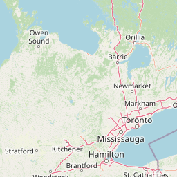
Map view of Eleanor Island Migratory Bird Sanctuary

Use this park location map to pinpoint Eleanor Island Migratory Bird Sanctuary in Canada, understand its exact geographic position, and read its mapped placement within the surrounding landscape more clearly.

Pigeon | © OpenStreetMap contributors

Location context for Eleanor Island Migratory Bird Sanctuary

Ontario
Park atlas

Discover related nature reserves, island sanctuaries, and regional conservation areas.

Exploring Parks Near Eleanor Island and Other Protected Landscapes in Ontario

Browse other protected areas near Eleanor Island to compare surrounding lake ecosystems and regional park geography across the Canadian Shield. Expanding the search helps reveal connected wildlife sanctuaries and mapped conservation landscapes throughout Ontario.
National parkOntario
About 35 km away#1 closest

West

Georgian Bay Islands National Park: Ontario National Park Protected Landscape Atlas

Explore mapped boundaries and regional geographic context.

Gain a comprehensive understanding of Georgian Bay Islands National Park as a distinct protected area within Ontario. This entry provides detailed geographic context, focusing on the park's mapped landscape, its protected status as a national park, and its position within the regional geography of Canada. It is designed for users seeking structured information about protected lands and their atlas-level significance.

Area
13.5 km²
Established
1929
IUCN
II
Visitors
27.5K annual
National parkOntario
About 111 km away#2 closest

South

Rouge National Urban Park: Ontario's Mapped Protected Landscape Atlas

Explore national park boundaries and regional geography.

Investigate Rouge National Urban Park, a designated national park situated in Ontario, Canada. This page provides detailed atlas-style information focusing on its mapped boundaries, regional geographic context, and its identity as a significant protected natural landscape. Understand the park's role within the broader Canadian atlas for landscape exploration.

Area
79.1 km²
Established
2015
IUCN
V
Relief
Mixed relief
National parkOntario
About 156 km away#3 closest

West

Bruce Peninsula National Park: National Park Protected Landscape and Geographic Context in Ontario

Discover its mapped boundaries and regional landscape identity.

Bruce Peninsula National Park stands as a protected national park entity within Ontario, offering a distinct geographic profile. Its mapped boundaries and position within the regional atlas are crucial for understanding its landscape character. MoriAtlas facilitates exploration of the park's protected status and its contribution to the conservation landscape of Ontario.

Area
154 km²
Established
1987
IUCN
II
Visitors
460.4K annual
Wildlife reserveOntario
About 180 km away#4 closest

Southeast

Wellers Bay National Wildlife Area: Coastal and Island Geography in Ontario

An important Great Lakes barrier beach protected reserve

Wellers Bay National Wildlife Area contains a rare collection of undeveloped shorelines, including the Baldhead peninsula and offshore islands. This protected area offers a deep look into the littoral processes of Lake Ontario, providing crucial sanctuary for waterbirds and endangered species within a fragile, compact, and natural woodland environment.

Area
0.74 km²
Established
1978
IUCN
Ia
Scope
Terrestrial
Wildlife reserveOntario
About 232 km away#5 closest

Southeast

Prince Edward Point National Wildlife Area: Protected Geography and Migration Hub

Coastal woodland and shoreline terrain in southeastern Ontario

Prince Edward Point National Wildlife Area is a federal reserve located on a narrow peninsula extending into Lake Ontario. This area features a diverse landscape of forest patches, open meadows, and jagged lakefront, providing critical refuge for migrating bird species. As a long-standing center for ornithological research, the site remains an essential node for understanding the regional migration patterns and natural heritage of the Great Lakes basin.

Area
5.6 km²
Established
1980
IUCN
Ia
Relief
Lowland
Marine protected areaMichigan
About 238 km away#6 closest

West

Thunder Bay National Marine Sanctuary: Geography and Protected Maritime Landscape Context

Mapping underwater heritage in the Michigan Great Lakes region

Spanning 4,300 square miles of Lake Huron, Thunder Bay National Marine Sanctuary preserves a significant collection of shipwrecks within a glacially shaped freshwater terrain. This marine protected area offers a look at submerged geography ranging from shallow coastal bays to deep lake basins. It serves as a vital anchor for understanding maritime history and freshwater ecosystem stability across the Michigan shoreline.

Area
11,000 km²
Established
2000
Relief
Lowland
Climate
Temperate
Watercolor painting of green hills, islands, and a body of water under a pale yellow sky
National parkOntario
About 248 km away#7 closest

East

Thousand Islands National Park: Exploring Ontario's Protected Landscape Geography

Discover the mapped terrain and regional context of this national park.

Uncover the protected landscape identity of Thousand Islands National Park, a key national park located in Ontario. This resource focuses on its geographic setting, mapped boundaries, and overall atlas context, providing a clear understanding of its role as a protected area. Explore how its unique terrain contributes to the regional geography and the broader national park network, offering valuable insight for landscape-focused discovery.

Area
24.4 km²
Established
1904
IUCN
II
Visitors
109.3K annual
Wildlife reserveOntario
About 248 km away#8 closest

East

Zugvogelschutzgebiet Mississippi Lake Protected Landscape and Wildlife Reserve Atlas

Waterfowl habitat and wetland geography in Ontario

Zugvogelschutzgebiet Mississippi Lake serves as a designated wildlife reserve providing essential staging grounds for migratory waterfowl. Located at the river-mouth interface on Mississippi Lake, the area encompasses provincially significant wetlands within Ewan Bay. This protected footprint offers a distinct look at the quiet, low-relief hydrology and marsh ecology characteristic of the broader southern Ontario basin.

Area
2.84 km²
Established
1959
IUCN
IV
Relief
Lowland

Common questions about visiting, size, designation, and location context for Eleanor Island Migratory Bird Sanctuary

Eleanor Island Migratory Bird Sanctuary FAQs for park facts, access, geography, and protected area context

Find quick answers about Eleanor Island Migratory Bird Sanctuary, including protected-area facts, park geography, trail and visitor context, and how the park fits into its surrounding country and regional landscape.
MoriAtlas Explorer

Continue Your Protected Areas Search Across the Global Atlas

Deepen your exploration by continuing the structured search for national parks and protected areas worldwide. Utilize the comprehensive filtering capabilities to compare different conservation landscapes and refine your understanding of global park geography. Discover more about the distribution and characteristics of protected natural areas.

Global natural geography