Mori Atlas logo
Nature reserveElzbachtal und Odenwald Neckargerach

A comprehensive geographic analysis of the Odenwald plateau and the dramatic Neckar Valley river corridors.

Elzbachtal und Odenwald Neckargerach: Mapped Protected Landscapes in the Baden-Württemberg Region

(FFH-Gebiet Elzbachtal und Odenwald Neckargerach)

Elzbachtal und Odenwald Neckargerach encompasses a distinct mosaic of protected habitat types, spanning from the steep sandstone gorges of the Neckar Valley to the undulating forests of the Odenwald plateau. This conservation area preserves significant ecological diversity including ravine forests, block scree slopes, and moist heathlands. Through our atlas, you can analyze the terrain and protected boundaries that define this vital environmental corridor in southwestern Germany.

Natura 2000FFH-GebietHabitats DirectiveNeckar ValleyOdenwaldmixed beech forest

Elzbachtal und Odenwald Neckargerach

Nature reserve

Park overview

Structured park overview, official facts, and landscape profile for Elzbachtal und Odenwald Neckargerach

Elzbachtal und Odenwald Neckargerach park facts, protected area profile, and essential visitor context

Review the core facts for Elzbachtal und Odenwald Neckargerach, including designation, size, terrain, visitor scale, habitats, and operating context in one park-focused overview.

About Elzbachtal und Odenwald Neckargerach

Elzbachtal und Odenwald Neckargerach is a European protected landscape in the northern part of Baden-Württemberg, where the Neckar River cuts a winding valley through the eastern edge of the Odenwald mountains. The site was assembled by merging earlier protected proposals around Neckargerach and Waldbrunn with the Elzbach Valley, creating a single Natura 2000 unit that captures both the valley corridor and the surrounding upland forest mosaic. Its two administrative districts give the area a transitional character between more rural Odenwald landscapes to the east and the denser settlement pattern of the Rhine-Neckar region to the west.

At its core, the site is defined by the Neckar Valley itself. The river runs through a landscape of steep, forested slopes, exposed sandstone cliffs, block scree pockets, and narrow tributary ravines. Side valleys such as the Elzbach bring near-natural stream systems into the protected area, while small lakes, spring mires, and moist tall herb fringes add hydrological richness. Above the valley, the Odenwald plateau carries extensive forests, patchy moors, and dry heaths that reflect a long history of low-intensity land use. Together, these elements form a tightly woven mosaic of forest, rock, wetland, and open habitat within a compact geographic frame.

Ecologically, the area matters because it preserves habitat types that have become fragmented across much of central Europe. The beech and mixed forests of the Odenwald plateau are complemented by rare ravine and slope forests along the Neckar Valley, where humid microclimates and unstable rock substrates create conditions for specialized plant communities. Open elements such as mat-grass swards, dry heaths, and species-poor hay meadows maintain semi-open structure amid the predominantly wooded matrix. Standing and flowing waters, including a lake within the site and brooks carrying vegetated aquatic flora, round out the habitat diversity typical of a well-connected Natura 2000 area.

From a conservation perspective, the site's significance lies in its combination of geographical reach and habitat breadth. By including both the dynamic valley system of the Neckar and representative sections of the Odenwald forest landscape, the area safeguards ecological processes ranging from river dynamics and slope erosion to forest succession and heathland persistence. This makes Elzbachtal und Odenwald Neckargerach not only a local refuge for characteristic flora and fauna, but also a regionally important component of the wider network of protected areas that links the Odenwald, the Neckar corridor, and the Rhine-Neckar region.

Quick facts and research context for Elzbachtal und Odenwald Neckargerach

Elzbachtal und Odenwald Neckargerach is listed as a Fauna-Flora-Habitat (FFH) area under the EU Habitats Directive, with site code DE-6521-311, and is formally integrated into the European Natura 2000 network. It lies in Baden-Württemberg, spanning the Neckar-Odenwald-Kreis and Rhein-Neckar-Kreis districts, with administrative responsibility held by the Regierungspräsidium Karlsruhe.

The site was initially proposed as a protected area in 2005 by the Regierungspräsidium Karlsruhe and was formally designated on 11 January 2019 through a regulation issued on 12 October 2018. Before its current designation, the area existed as two predecessor sites known as Odenwald Neckargerach-Waldbrunn and Elzbachtal, which were merged into the present-day protected entity. The landscape comprises the Neckar Valley with its forested slopes, tributary valleys, sandstone gorges, raised bogs, heath, and old-growth forest types typical of the Odenwald region.

Protection and recognition

Documented protection parameters and verified international recognition metrics

Elzbachtal und Odenwald Neckargerach Protection Status and Terrestrial Conservation Data

Elzbachtal und Odenwald Neckargerach maintains a registered terrestrial protection status backed by structured database records. Verified international recognition sources and official designation parameters provide reliable context for conservation research.

Protection details

Protection scope
Terrestrial
Transboundary protection
No
WDPA ID
555623496
Park context

Deeper park guide and search-rich context for Elzbachtal und Odenwald Neckargerach

Elzbachtal und Odenwald Neckargerach history, landscape, wildlife, and travel context

Explore Elzbachtal und Odenwald Neckargerach through its history, landscape character, ecosystems, wildlife, conservation priorities, cultural context, and seasonal travel timing in a structured park guide built for atlas discovery and search intent.

Why Elzbachtal und Odenwald Neckargerach stands out

The site is best known for the way it combines the deeply incised Neckar Valley with the adjoining Odenwald highlands, producing a rich mosaic of forest, rock, wetland, and grassland habitats within a single Natura 2000 area. The Neckar Valley flanks are particularly notable for their steeply wooded slopes, sandstone gorges, and block scree formations, while the Odenwald plateau contributes extensive old-growth beech and mixed forests along with moor and heath communities. Beyond its dramatic landforms, the area is recognized for the diversity of Annex I habitat types it preserves. These include several rare forest types such as ravine and slope mixed forests, Stellaria oak-hornbeam forests, and Luzulo and Galio beech forests, as well as open habitats such as mat-grass swards, Molinia meadows, dry heaths, nutrient-rich standing waters, and naturally flowing watercourses with submerged vegetation. This combination of forest complexity, valley geomorphology, and open habitat diversity defines the area's distinctive conservation profile.
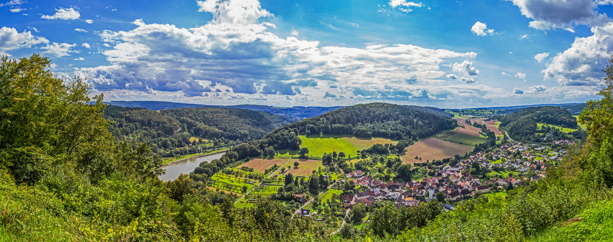
A wide, panoramic view from a high vantage point overlooking the town of Neckargerach, nestled in the green valley of the Neckar River, surrounded by forested hills under a blue sky with scattered white clouds.
Panoramic view overlooking the town of Neckargerach and the Neckar River valley.

Elzbachtal und Odenwald Neckargerach history and protected-area timeline

The protected area originated through the European Natura 2000 process. In 2005, the Regierungspräsidium Karlsruhe submitted the site as a candidate Fauna-Flora-Habitat area under the EU Habitats Directive, drawing on two earlier proposed zones known as Odenwald Neckargerach-Waldbrunn and Elzbachtal. These had previously circulated as independent designation proposals before being consolidated into a single larger area.

After years of review within the Natura 2000 framework, the area was formally designated through a regulation issued by the Regierungspräsidium Karlsruhe on 12 October 2018, which came into force on 11 January 2019. With this act, the mergers of the predecessor sites were completed and the present-day boundary of the FFH-Gebiet Elzbachtal und Odenwald Neckargerach was set. Management responsibility rests with the same regional authority that proposed and designated the site, and its conservation objectives are embedded in the broader European protected-area network.

Elzbachtal und Odenwald Neckargerach landscape and geographic character

The landscape of Elzbachtal und Odenwald Neckargerach is shaped by the long erosional work of the Neckar River and its tributaries against the sandstone and crystalline basement rocks of the eastern Odenwald. From the river level, the terrain climbs sharply into wooded valley flanks whose profiles are broken by rock outcrops, boulder fields, and the steep incisions of side valleys. These flanks are among the most visually distinctive elements of the site, alternating between continuous forest cover and more open rocky or scree-dominated patches.

Away from the Neckar corridor, the land surface rises onto the broader Odenwald plateau. Here, gentle relief, deeper soils, and long-established forest cover produce a different visual character: a wide, softly undulating highland traversed by forest tracks and crossed by smaller stream valleys. Wet depressions and former land-use relicts appear as patches of moor and heath that interrupt the otherwise dense woodland canopy. The result is a landscape of strong contrasts, in which the dramatic geometry of the Neckar Valley consistently meets the quieter, more uniform surface of the Odenwald uplands.

Hydrological features add further variety. Apart from the Neckar itself, small lakes, spring-fed mires, and brooks with near-natural flow regimes weave through both the valley and the plateau. Sandstone gorges and block screes along the steeper slopes underline the geological character of the area, marking zones where natural disturbance processes such as rockfall, slope movement, and erosion remain part of the ongoing landscape dynamics.

Elzbachtal und Odenwald Neckargerach ecosystems, habitats, and plant life

Ecologically, the site functions as a meeting point between lowland riverine systems and the deciduous forests of the Odenwald mountains. The Neckar Valley and its side streams support moist and humid forest communities, including types associated with ravines, slope hollows, and nutrient-rich stream margins, while the plateau carries classic Central European beech and mixed forest associations.

The ecological richness of the area is closely tied to its habitat diversity. Forest types range from highly specialized ravine and slope mixed forests to Stellaria oak-hornbeam forests and both Hainsimsen and Waldmeister beech forests. Open habitats, although less extensive, are biologically significant: dry heaths, mat-grass swards, moist tall herb fringes, and nutrient-poor hay meadows contribute species pools that differ fundamentally from those of the surrounding woodland. Aquatic habitats, including a natural lake, brooks with submerged vegetation, and small spring communities, integrate the wet elements into the broader ecological network.

Particularly important is the link between the valley and the plateau. The transition zones where slope forests meet small grassland patches, where headwater streams emerge as spring mires, or where block scree gives way to stabilized woodland form crucial ecological gradients. These gradients sustain specialized microhabitats and allow gradual species turnover between the valley and the upland, which strengthens the overall resilience and biodiversity value of the protected area.

Elzbachtal und Odenwald Neckargerach wildlife and species highlights

While the available sources emphasize habitat types rather than species lists, the wildlife value of the area follows directly from its forest, rock, water, and open-habitat mosaic. The extensive beech and mixed forests of the Odenwald plateau provide habitat for typical woodland fauna of the region, including deer, wild boar, and a range of smaller mammals and forest birds, while the structurally complex slope forests and ravine woodlands along the Neckar Valley offer refuges for species associated with old-growth forest and humid microclimates.

The river, side streams, lake, and spring mires contribute freshwater and wetland habitats that support amphibian, aquatic invertebrate, and fish communities typical of near-natural low mountain rivers. Open structures such as dry heaths, mat-grass swards, and species-rich meadows are particularly important for invertebrates, pollinators, and bird species that depend on semi-open landscapes. Together with rocky and scree habitats, these open and semi-open features add a different ecological dimension to the predominantly forested matrix and broaden the range of niches available to wildlife in the protected area.

Elzbachtal und Odenwald Neckargerach conservation status and protection priorities

From a conservation perspective, Elzbachtal und Odenwald Neckargerach is significant as a representative example of how valley and upland habitats can be bundled into a single Natura 2000 site. Its designation safeguards a variety of habitat types listed under Annex I of the EU Habitats Directive, including several forest types that are now reduced across much of central Europe, as well as open habitat types such as dry heaths and mat-grass swards that depend on continued low-intensity management.

The protected area also plays an important role in maintaining ecological connectivity in the region. By covering substantial sections of the Neckar Valley in conjunction with adjacent Odenwald forest landscapes, it links core woodland habitat with river corridors, slope forests, and open cultural landscapes. This connectivity is central to long-term conservation aims, allowing species to move between valley and plateau habitats and supporting the natural dynamics of river, slope, and forest ecosystems. The administrative responsibility of the Regierungspräsidium Karlsruhe provides a stable institutional framework for monitoring and managing the site under Natura 2000 requirements.

Elzbachtal und Odenwald Neckargerach cultural meaning and human context

The cultural context of the protected area is closely tied to the long-standing interaction between local communities and the Odenwald landscape. The mosaic of forest, valley meadows, heath patches, and small agricultural areas reflects centuries of low-intensity land use, including woodland grazing, mowing of slope meadows, and traditional forestry. The village of Neckargerach itself, after which the site is partly named, is integrated into the protected area as a longstanding settlement in the Neckar Valley, and the surrounding landscape continues to bear visible traces of this rural, forested cultural environment. Beyond this broad rural-woodland identity, no specific cultural or historical themes are foregrounded in the source material.

Top sights and standout views in Elzbachtal und Odenwald Neckargerach

Among the area's strongest distinguishing features is the tight coexistence of deep river-valley geomorphology and extensive Odenwald forest within one continuous protected area. The Neckar Valley flanks offer a striking combination of steep slopes, sandstone gorges, and block scree, while the adjacent plateau hosts an unusually rich set of forest types. The merging of the earlier Elzbachtal and Odenwald Neckargerach-Waldbrunn proposals into a single Natura 2000 unit means that visitors and researchers encounter a coherent ecological region rather than a collection of isolated fragments.

Another highlight is the habitat diversity. Annex I habitat types range from highly specialized forest communities on rocky slopes and in ravines to open cultural habitats such as dry heaths, moist tall herb fringes, and mat-grass meadows, complemented by aquatic habitats including a lake and brooks with submerged vegetation. Together with the long-term protection framework provided by Natura 2000 and the Regierungspräsidium Karlsruhe, this combination defines Elzbachtal und Odenwald Neckargerach as a regionally significant conservation area in the eastern Odenwald and Neckar corridor.

Best time to visit Elzbachtal und Odenwald Neckargerach

The site is a protected natural area rather than a tourism-oriented park, and the source material does not provide specific seasonal visitor guidance. In general, late spring and early summer are well suited to experiencing the full range of habitats, when forest ground vegetation is in bloom and grassland and heath systems are most visible. Early autumn, when the beech and mixed forests of the Odenwald plateau turn color, offers a particularly atmospheric view of the woodland landscape, while winter can highlight the geological structure of the valley flanks, exposed rocks, and bare deciduous forests. Visitors should treat the area primarily as a place for quiet landscape and nature observation rather than as a destination with managed seasonal programming.

Monthly climate preview

Long-term monthly temperature ranges and precipitation rhythm for Elzbachtal und Odenwald Neckargerach

Elzbachtal und Odenwald Neckargerach Climate Normals and Annual Weather Patterns

Historical climate data reveals measured monthly averages for temperature and precipitation at a representative coordinate within Elzbachtal und Odenwald Neckargerach. Examining the full twelve-month statistical record provides deeper context on long-term environmental conditions across the protected terrain.
Annual mean9 °C
0 °C19 °C
Jan
Feb
Mar
Apr
May13°
Jun17°
Jul19°
Aug19°
Sep15°
Oct
Nov
Dec
Warmest month
July

19.5 °C

Coolest month
January

-0.5 °C

Wettest month
July

2.5 mm/day

Driest month
April

1.5 mm/day

Park location guide

Geography guide, regional context, and park location map for Elzbachtal und Odenwald Neckargerach

Elzbachtal und Odenwald Neckargerach park geography, regions, and map view in Germany

Understand where Elzbachtal und Odenwald Neckargerach sits in Germany through a broader geographic reading of the surrounding landscape, nearby location context, and its mapped position within the national park landscape.

How Elzbachtal und Odenwald Neckargerach fits into Germany

Germany is a federal republic in Western and Central Europe with a population of over 83 million across sixteen constituent states. It is Europe's largest economy by nominal GDP and a major global exporter and importer. The capital is Berlin, and the country borders Denmark, Poland, Czech Republic, Austria, Switzerland, France, Luxembourg, Belgium, and the Netherlands.

Wider geography shaping Elzbachtal und Odenwald Neckargerach in Germany

Germany is located in Western and Central Europe, spanning 357,022 km². It borders Denmark to the north, Poland and the Czech Republic to the east, Austria and Switzerland to the south, and France, Luxembourg, Belgium, and the Netherlands to the west. The country has coastlines on the Baltic Sea and North Sea to the north, with the Alps located in the southern region.

Map view of Elzbachtal und Odenwald Neckargerach

Use this park location map to pinpoint Elzbachtal und Odenwald Neckargerach in Germany, understand its exact geographic position, and read its mapped placement within the surrounding landscape more clearly.

Pigeon | © OpenStreetMap contributors

Location context for Elzbachtal und Odenwald Neckargerach

Baden-Württemberg

Visualizing the protected habitats, sandstone gorges, and river valley terrain

Elzbachtal und Odenwald Neckargerach Landscape Photos and Scenery

Elzbachtal und Odenwald Neckargerach imagery captures the dramatic transition from steep river valley slopes to the rolling upland plateau. Visual documentation reveals the complex forest canopy, exposed rock formations, and near-natural stream corridors that define the protected landscape.

A wide, panoramic view from a high vantage point overlooking the town of Neckargerach, nestled in the green valley of the Neckar River, surrounded by forested hills under a blue sky with scattered white clouds.

Park atlas

Compare adjacent river valleys and highland protected landscapes across Baden-Württemberg.

Parks Near Elzbachtal und Odenwald Neckargerach and Surrounding Protected Areas

Browse other protected areas and regional nature reserves situated near Elzbachtal und Odenwald Neckargerach. Comparing adjacent river valleys and upland forest terrain helps reveal the broader ecological patterns of the surrounding Odenwald region.
Watercolor painting of a gentle, rolling green landscape with sparse trees and distant hills on a white background.
Nature reserveHesse
About 21 km away#1 closest

Northwest

Jakobsgrund bei Gammelsbach Nature Reserve: Geographic Atlas and Park Boundary Mapping

Protected sandstone valley landscapes in southern Hesse

This nature reserve in the Odenwald hills provides a concentrated example of traditional valley land use. The area features a sharp contrast between dry south-facing slopes and damp, stream-carved lowlands, creating a botanical hotspot within the regional geography of Hesse, Germany.

Area
0.095 km²
Established
1996
IUCN
IV
Relief
Upland
A soft, horizontal watercolor painting depicting a meandering stream flowing through green meadows and rolling hills under a pale sky.
Nature reserveHesse
About 23 km away#2 closest

West

Finkenbachtal bei Finkenbach Nature Reserve: Mapped Brook Valleys of the Odenwald

Protected stream corridor and floodplain meadows in southern Hesse

Finkenbachtal bei Finkenbach preserves a compact, ecologically intact valley system characterized by meandering sandstone brook morphology and traditional floodplain meadow management. This protected area serves as a significant link in the regional Odenwald stream network, illustrating the intersection of low mountain forest and valley floor vegetation dynamics.

Area
0.276 km²
Established
1981
Relief
Upland
Climate
Temperate
Nature reserveBaden-Württemberg
About 23 km away#3 closest

Southeast

Jagsttal bei Schöntal und Klosterwald: Protected Nature Reserve Landscape Overview

Geographic profile of the Jagst-Kocher plateau in Baden-Württemberg

Spanning the high plateau between the Jagst and Kocher rivers, this protected area features a unique vertical transition from continuous beech forest canopy to steep ravines and calcareous valley slopes. The landscape encompasses a complex mix of traditional orchard meadows, dry grasslands, and specialized freshwater tufa springs, serving as a representative example of the regional ecological heritage in southwest Germany.

Area
12.605 km²
Established
2019
Relief
Upland
Climate
Temperate
A watercolor illustration of rolling hills in shades of purple and green against a white background.
Nature reserveBaden-Württemberg
About 27 km away#4 closest

East

Jagsttal Dörzbach-Krautheim Protected Area: Landscape Geography and Atlas Map Context

Nature reserve featuring karst features and riparian corridors

Spanning the Jagst river valley in Baden-Württemberg, Jagsttal Dörzbach-Krautheim showcases a sophisticated mosaic of dry calcareous grasslands and wet floodplain woodlands. This atlas entry focuses on the park boundary geography, identifying the intersection of limestone scree slopes, plateau forests, and karst caves that create its distinct ecological profile. Gain a comprehensive view of how these features form a vital conservation link within the regional river network.

Area
17.502 km²
Established
2005
Relief
Mixed relief
Climate
Temperate
Watercolor painting of soft, rolling green hills and meadows in a minimalist style, set against a light background.
Nature reserveHessen
About 27 km away#5 closest

Northwest

Dürr-Ellenbachtal von Wald-Michelbach: Odenwald Nature Reserve and Protected Valley Geography

A historic meadow valley in Hessen, Germany

The Dürr-Ellenbachtal von Wald-Michelbach nature reserve protects an elongated, narrow valley framed by forested ridges in the central Odenwald. This area is defined by its meandering brook, diverse alder stands, and species-rich meadows that sustain significant local biodiversity. As a key Natura 2000 site, it serves as an essential example of protected meadow landscapes and rural mountain terrain within the Bergstraße district.

Area
0.542 km²
Established
1990
IUCN
IV
Relief
Mountain
A horizontal watercolor illustration depicting a meandering stream through green valley meadows, flanked by soft foliage and rolling hills in the background.
Nature reserveOdenwaldkreis
About 29 km away#6 closest

North

Geierstal von Vielbrunn Nature Reserve: Odenwald Landscape and Geography

Protected brook valley and floodplain ecosystems

Geierstal von Vielbrunn is a distinct nature reserve in Odenwaldkreis, characterized by a narrow valley floor carved by the Ohrenbach stream. The site preserves rare sedge fens, tall herb communities, and black alder galleries that provide essential refuge for regional wildlife. This protected landscape highlights the complex ecological transition between Hessian and Bavarian forest zones in a compact, valley-bottom geography.

Area
0.16 km²
Established
2000
Relief
Upland
Climate
Temperate
A wide watercolor painting showing rolling green hills and trees with pale pink and yellow hues across a valley landscape.
Nature reserveHessen
About 29 km away#7 closest

Northwest

Rotes Wasser von Olfen Nature Reserve: Protected Wetland and Odenwald Geography

A unique bog and iron-rich stream landscape in Hessen, Germany.

Rotes Wasser von Olfen preserves a rare, small-scale mosaic of transitional bog and wet meadow vegetation within the Odenwald range. This protected site features reddish, iron-rich seepage waters and provides essential habitat for specialized flora and dragonfly populations amidst a surrounding forested mountain landscape.

Area
0.121 km²
Established
1980
IUCN
IV
Relief
Upland
A horizontal watercolor painting showing rolling green hills, a winding stream in the foreground, and a single tree on the right.
Protected landscapeRhein-Neckar-Kreis
About 29 km away#8 closest

West

Odenwald Protected Landscape: Geography and Regional Mapping in Rhein-Neckar-Kreis

Exploring the characteristic Odenwald mountain terrain and valley systems

This protected landscape encompasses over 6,000 hectares of diverse topography in northern Baden-Württemberg. The terrain features a classic Odenwald relief, defined by narrow V-shaped valley notches, riparian woodlands, and structural mosaics of forest and meadow. Gain insight into the geographic and ecological character of these protected stream catchments and ridgelines.

Area
60.775 km²
Established
1996
IUCN
V

Common questions about visiting, size, designation, and location context for Elzbachtal und Odenwald Neckargerach

Elzbachtal und Odenwald Neckargerach FAQs for park facts, access, geography, and protected area context

Find quick answers about Elzbachtal und Odenwald Neckargerach, including protected-area facts, park geography, trail and visitor context, and how the park fits into its surrounding country and regional landscape.
MoriAtlas Explorer

Continue Your Protected Areas Search Across the Global Atlas

Deepen your exploration by continuing the structured search for national parks and protected areas worldwide. Utilize the comprehensive filtering capabilities to compare different conservation landscapes and refine your understanding of global park geography. Discover more about the distribution and characteristics of protected natural areas.

Global natural geography