Why Esteros y Algarrobales del Río Uruguay stands out
Esteros y Algarrobales del Río Uruguay is best known for protecting a rare Uruguayan overlap of Espinal and Chaco biotic elements, expressed through its algarrobo (Prosopis) forests on sodic blanqueales soils and its estero wetlands along the Uruguay River. The combination of dry-adapted Prosopis woodlands and permanently or seasonally flooded coastal bañados makes this area unusually diverse for its size, and ecologically distinctive within Uruguay as a whole. The protected area is also recognized for its integration into the broader Esteros de Farrapos wetland system. Part of its territory lies within a Ramsar-listed wetland and lies immediately adjacent to the Esteros de Farrapos National Park, making it a significant component of one of Uruguay's most important riparian and wetland conservation corridors.
Esteros y Algarrobales del Río Uruguay history and protected-area timeline
The protected area was formally incorporated into Uruguay's National System of Protected Natural Areas (SNAP) under Law 16462, with Decree 341/015 providing the regulatory framework for its establishment. This makes it a relatively recent addition to the country's conservation network, in line with Uruguay's broader early-twenty-first-century push to formalize protection for previously unprotected but ecologically valuable landscapes, including riparian wetlands and native woodland remnants.
The site's formal recognition was driven by the recognition that the algarrobo woodlands and estero wetlands along this stretch of the Uruguay River were both biologically distinctive and insufficiently represented in the existing protected-area system. By integrating the area into SNAP and aligning part of it with the Ramsar-listed Esteros de Farrapos wetland system, Uruguay effectively linked legal recognition of the site with international wetland conservation commitments.
Esteros y Algarrobales del Río Uruguay landscape and geographic character
The landscape of Esteros y Algarrobales del Río Uruguay is defined by the transition between the Uruguay River corridor and the dry interior lowlands of Río Negro department. The river itself forms the eastern boundary, while the protected area extends westward onto a strip of low-lying terrain marked alternately by shallow estero wetlands, seasonally flooded bañados, and patches of dry upland dominated by sodic blanqueales soils.
The most visually distinctive feature is the contrast between flooded areas and woodland. The esteros form meandering belts of wetland vegetation following old river channels and low-lying floodplain depressions, while the algarrobo woodlands rise above these zones on lighter, more saline soils. Gallery forests line the active edges of the river and its connecting channels, giving way to grasslands and matorral scrub on the better-drained ground beyond. The result is a finely textured landscape of intertwined ridges and pools, with the river itself providing both the hydrological engine and the dramatic backdrop.
Esteros y Algarrobales del Río Uruguay ecosystems, habitats, and plant life
Ecologically, the protected area sits at the southern edge of the Espinal and a transitional contact zone with the Chaco, two ecoregions whose biotic communities occur only in a very restricted way within Uruguay. The site's identity is shaped by this overlap, with Prosopis-dominated woodlands representing the dry-forest component and the estero and bañado systems representing the humid counterpart.
The algarrobo forests developed on blanqueales soils are the habitat's signature ecological feature. They support a specialized set of native flora and fauna adapted to high soil sodium content and seasonal hydrological stress, and they connect the area to woodland communities more typical of northern Argentina, Paraguay, and southern Brazil. The accompanying wetland and gallery-forest systems add amphibian, reptile, bird, and mammal habitat that depends on the seasonal pulse of the Uruguay River. Together, these features give the protected area disproportionate ecological importance relative to its relatively modest size.
Esteros y Algarrobales del Río Uruguay wildlife and species highlights
Because the source material describes the area primarily through its habitats and ecoregional context rather than through specific species inventories, wildlife content for Esteros y Algarrobales should be understood in broadly ecological rather than enumerative terms. The Prosopis woodlands on blanqueales soils support flora and fauna typical of the southern Espinal and Chaco margins, including species that are otherwise weakly represented in Uruguay. The esteros and coastal bañados, by contrast, sustain wetland-associated fauna tied to the Uruguay River's seasonal flooding.
Esteros y Algarrobales del Río Uruguay conservation status and protection priorities
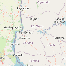
The conservation significance of Esteros y Algarrobales del Río Uruguay lies in its role as a southern anchor for the broader Esteros de Farrapos wetland system. About 41 percent of its surface overlaps with the Ramsar site Esteros de Farrapos e Islas del Río Uruguay, and the protected area sits only about four kilometers south of the Esteros de Farrapos National Park. This makes it not an isolated reserve but a critical southern extension of a regional conservation corridor.
Its management category, as a SNAP habitat and species management area, emphasizes the need to maintain both the algarrobo woodlands on sodium-rich soils and the estero wetlands in a functional state, rather than protecting a single dominant landscape. By integrating a part of its territory with a Ramsar-listed wetland, the area bridges Uruguay's domestic protected-area framework with international commitments to wetland conservation, particularly under the Ramsar Convention.
Esteros y Algarrobales del Río Uruguay cultural meaning and human context
The cultural framing of this area is closely tied to the traditional rural and riparian identity of western Uruguay. The esteros and the algarrobo woodlands have long shaped local land use in the Río Negro department, from seasonal livestock grazing and small-scale forestry to the cultural vocabulary of the southern Cone, where algarrobo and estero carry strong regional resonance.
The reserve's place within the SNAP system also reflects a national-level recognition that landscape elements once taken for granted in the countryside, particularly Prosopis woodlands and floodplain wetlands, have become rare and ecologically valuable at the country scale. This shift in perspective, from everyday rural landscape to nationally protected heritage, is itself an important cultural development around this stretch of the Uruguay River.
Top sights and standout views in Esteros y Algarrobales del Río Uruguay
Esteros y Algarrobales del Río Uruguay stands out for the unusually tight coexistence of Prosopis algarrobo woodland and estero wetland along a short stretch of the Uruguay River. The site's blanqueales soils support dry-forest communities that are otherwise scarce in Uruguay, while the esteros and coastal bañados carry the hydrological character of the broader Río Uruguay floodplain.
Its integration into the Esteros de Farrapos Ramsar site and its proximity to the Esteros de Farrapos National Park also make it a key component of one of Uruguay's most coherent wetland conservation corridors, and its formal designation under SNAP through Law 16462 and Decree 341/015 underscores its national-level recognition.
Best time to visit Esteros y Algarrobales del Río Uruguay
The character of Esteros y Algarrobales del Río Uruguay varies considerably with the hydrological cycle of the Uruguay River. Periods of higher water levels tend to expand the esteros and bañados, intensifying the wetland character of the area and concentrating waterbird activity along the river's edge. Drier periods expose more of the algarrobo woodland and gallery forest, making the dry-forest component of the landscape easier to appreciate and access.
For visitors focused on the wetland dimension, the most dramatic conditions typically align with the wetter phases of the regional climate, when the esteros are full and the contrast between flooded open water and the surrounding woodland is at its sharpest. For those more interested in the Prosopis woodlands and soils of the blanqueales, drier periods offer a clearer view of the dry-forest landscape that gives the area much of its identity.