


Mori Atlas logo
National parkFarallones de Cali

Discover the protected landscapes and geographical context of Farallones de Cali National Park.

Farallones de Cali National Park: Mapped Protected Area and Regional Geography

(PNN Farallones de Cali)

Farallones de Cali National Park represents a significant protected landscape within Valle del Cauca Department, Colombia. This atlas-focused page details its mapped boundaries and geographic position, offering a clear understanding of its regional setting. Explore the structured data that defines this protected area and its place within the natural geography of the region.

Andean mountainsCloud forestPáramoTropical rainforestBirdwatchingWatershed protection
Stylized illustration showing mountains, waterfall, and tropical plants in a park setting

Farallones de Cali

National park

Park overview

Structured park overview, official facts, and landscape profile for Farallones de Cali

Farallones de Cali park facts, protected area profile, and essential visitor context
Review the core facts for Farallones de Cali, including designation, size, terrain, visitor scale, habitats, and operating context in one park-focused overview.

About Farallones de Cali

Farallones de Cali represents a cornerstone of conservation in southwestern Colombia, protecting a montane landscape of extraordinary ecological and hydrological significance. The mountain cluster rises abruptly from the Cauca Valley floor west of Cali, forming a steep wall of peaks and ridges that intercept moisture-laden Pacific winds, creating the precipitation patterns that sustain the region's water cycle. The protected area extends across both the eastern and western slopes of the West Andes, encompassing the watersheds of numerous rivers that flow eastward into the Cauca River system and westward directly into the Pacific Ocean. This dual-watershed position gives the park outsized importance for regional water security, as the rivers originating here provide drinking water and hydroelectric power for millions of people in the Cali metropolitan area and beyond. The vertical ecological gradient from tropical lowland forest through cloud forest and montane forest to alpine páramo creates a tapestry of habitats that supports remarkable species diversity, making this one of the most important conservation areas in the Chocó Biogeographic Region. Visitors access the park primarily via the Pance River valley from the south or through Peñas Blancas and the Pichindé River from the north, while the Anchicayá area is reached through the town of El Queremal.

Quick facts and research context for Farallones de Cali

Farallones de Cali spans 150,000 hectares along the Pacific slope of Colombia's West Andes. The protected area rises from 200 meters in the tropical lowlands to 4,050 meters at Punta Pance, creating dramatic elevation diversity. Average rainfall ranges from 2,500 mm in the mountainous sector to 6,000 mm in the Pacific region, ensuring year-round water availability for the rich ecosystems. Temperature gradients span from 25°C in the foothills to 5°C in the páramo zone. The park contains three administrative districts (Pichinde, Andes, and Leonera) and protects vital watersheds that supply Cali with drinking water and electricity. The area is managed under Colombia's National System of Protected Areas (SINAP) as an IUCN Category II national park.

Park context

Deeper park guide and search-rich context for Farallones de Cali

Farallones de Cali history, landscape, wildlife, and travel context
Explore Farallones de Cali through its history, landscape character, ecosystems, wildlife, conservation priorities, cultural context, and seasonal travel timing in a structured park guide built for atlas discovery and search intent.

Why Farallones de Cali stands out

Farallones de Cali is best known for its exceptional biodiversity concentrated along the Pacific slope of the West Andes, one of the world's most species-rich regions. The park protects critical habitat for over 300 bird species, including endemic treasures like the multicolored tanager, crested ant-tanager, and chestnut wood-quail. The famous Andean cock-of-the-rock performs its lek displays in the Peñas Blancas area of the Pichindé River valley. The mountain range also supports five primate species including the Colombian spider monkey and mantled howler, as well as the spectacled bear in the western slope forests. The dramatic landscape features craggy peaks visible from Cali, deep river canyons descending to the Pacific, and isolated páramo ecosystems that lack the characteristic Espeletia plants found in other Colombian páramos.
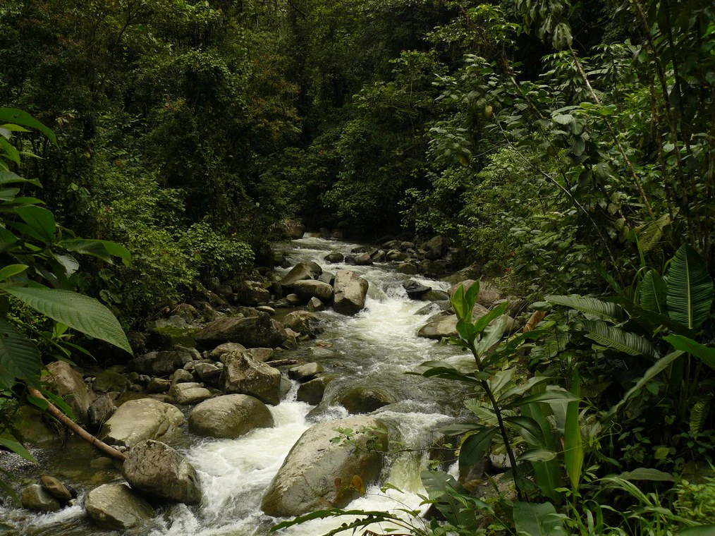
River with white water flowing over rocks surrounded by lush green vegetation
Anchicaya River flowing through dense forest in Farallones de Cali National Park

Farallones de Cali history and protected-area timeline

Farallones de Cali was established as a national park in 1968, becoming the largest protected area in Valle del Cauca Department and a landmark in Colombia's developing national park system. The creation of the park reflected growing recognition in the 1960s of the need to preserve the exceptional biodiversity and watersheds of Colombia's Andean regions. The protected area was incorporated into Colombia's National System of Protected Areas (SINAP), which coordinates conservation management across the country's national parks and other protected categories. Prior to formal protection, the Farallones mountains had long served as a vital resource for the region, with local communities relying on the rivers, forests, and mountain pastures. The park's establishment came during a period of expanding environmental consciousness in Latin America, and the Farallones area was selected for its unique combination of biodiversity value, watershed importance, and proximity to a major urban center. The park has maintained its protected status through subsequent decades despite increasing pressures from development, agriculture, and population growth in the surrounding Valle del Cauca.

Farallones de Cali landscape and geographic character

The landscape of Farallones de Cali is defined by a spectacular array of steep mountain terrain rising from the Pacific lowlands to create one of the most visually striking segments of Colombia's West Andes. The craggy peaks known collectively as Los Farallones (the Cliffs) give the mountain range its name and create dramatic silhouettes visible from Cali on clear days. The eastern foothills descend directly into the Cauca Valley, where the mountainfront meets the flat valley floor near the city. On the western slope, numerous river canyons have been carved by the heavy Pacific rainfall, with rivers like the Dagua and Anchicayá cutting deep valleys as they descend toward the ocean. The highest point at Punta Pance reaches 4,050 meters, commanding sweeping views that encompass the Pacific coast and port of Buenaventura to the west, the Cauca River valley and city of Cali to the east, and the Central Range with Nevado del Huila visible to the south. Other notable peaks include Pico de Loro (Parrot Peak) at 2,832 meters and Alto del Buey at 3,480 meters. The landscape also includes the Valley de los Osos (Bear Valley), Macizo Cajambres, and the high-altitude lagoons near Punta Pance.

Panoramic view of mountain peaks under partly cloudy sky
Panoramic view of Farallones de Cali mountain range

Farallones de Cali ecosystems, habitats, and plant life

The ecological diversity of Farallones de Cali reflects its position along the Pacific slope of the West Andes within the globally significant Chocó Biogeographic Region. Between 200 and 1,000 meters, tropical wet to humid forest covers the lower slopes with a canopy reaching 40 meters, characterized by tall rainforest trees, dense lianas, and abundant epiphytes. The subtropical cloud forest zone between 1,200 and 2,000 meters is perpetually shrouded in fog and supports an extremely mossy understory with countless epiphytic plants growing on every surface. This Subandean Forest gives way to montane forest between 2,000 and 3,500 meters, where dense vegetation forms a canopy up to 20 meters high, with tree height decreasing as elevation increases. Above 3,500 meters, the páramo ecosystem represents an unusual isolated pocket of alpine grassland that lacks the Espeletia (frailejones) plants typical of Colombian páramos, making this a distinct ecological variant. The western slope between 200 and 1,000 meters supports dry tropical forest with trees reaching 40 meters and tall grasses beneath, featuring endemic species like cargadera, wild cacao, and various palms including taparín and pambil.
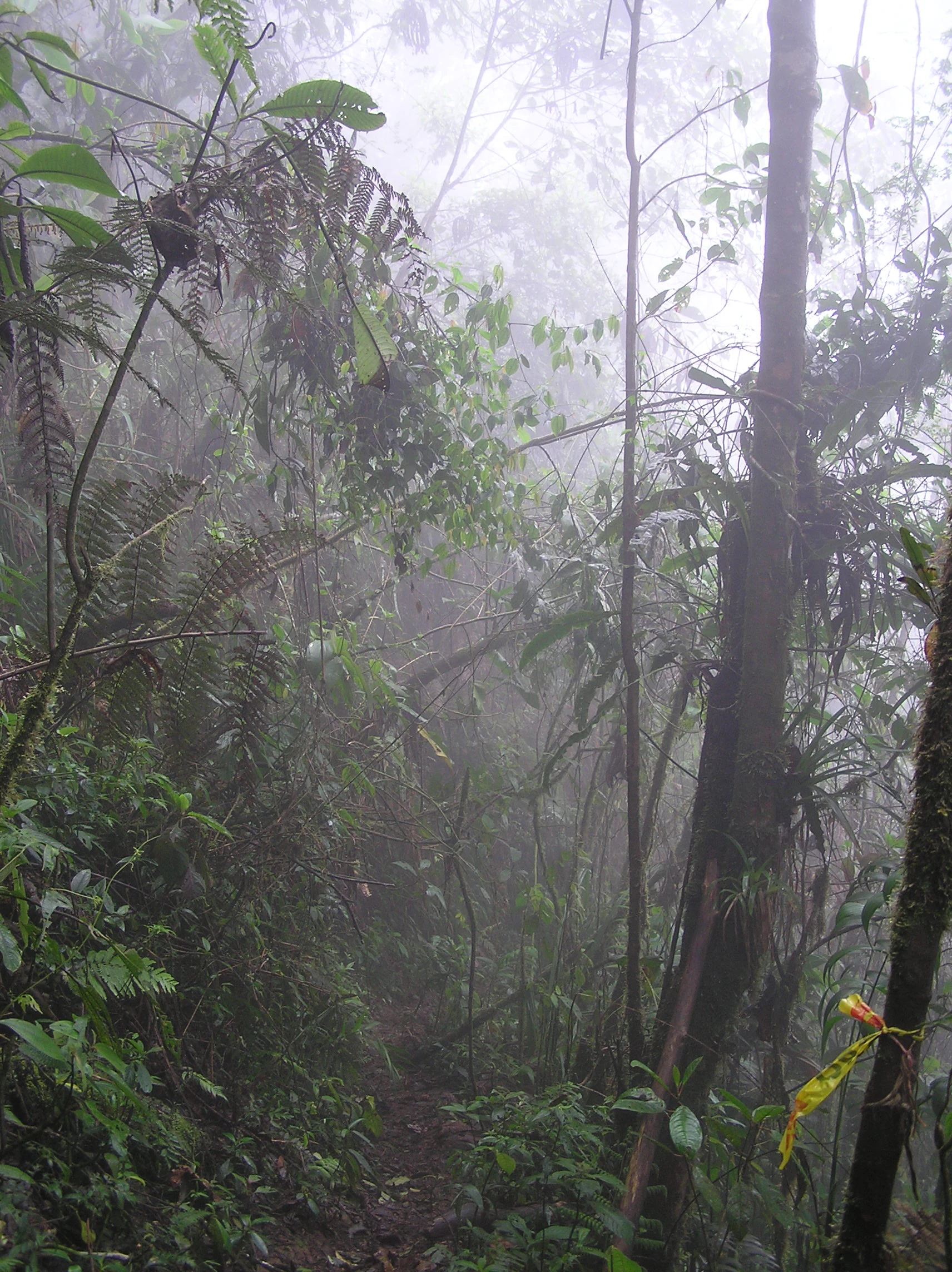
Misty forest trail surrounded by dense tropical vegetation including ferns, moss-covered branches, and tall trees
Misty trail through the tropical humid forest of Farallones de Cali National Park

Farallones de Cali wildlife and species highlights

Farallones de Cali supports exceptional wildlife diversity, with over 300 bird species documented in the park. The avifauna includes several endemic species found nowhere else, such as the multicolored tanager, crested ant-tanager, and chestnut wood-quail. The Andean cock-of-the-rock, Colombia's national bird, gathers at famous lek sites in the Peñas Blancas area of the Pichindé River valley, drawing visitors seeking one of the most spectacular bird displays in the Andes. The Anchicayá region is world-renowned among ornithologists for its exceptional bird diversity. Mammal populations include five primate species: the white-headed capuchin, red howler, mantled howler, gray-bellied night monkey (listed as vulnerable and locally called Marteja), and the Colombian spider monkey (vulnerable, locally called Marimonda). The spectacled bear, South America's only bear species, has suitable habitat on the western slope and is listed as vulnerable. Other mammals include various bats, squirrels, procyonids, anteaters, felids, foxes, and marsupials. Amphibians include the red-banded poison frog (Dendrobates lehmanni, also known as Oophaga lehmanni) and Bufo hypomelas.
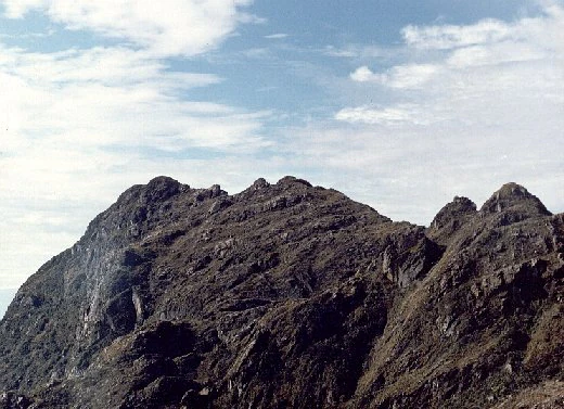
Rocky mountain peaks of Punta Pance under a partly cloudy sky with visible rugged terrain and distant clouds
Punta Pance mountain peaks under a partly cloudy sky

Farallones de Cali conservation status and protection priorities

Farallones de Cali plays a critical conservation role as the largest protected area in Valle del Cauca and a stronghold for biodiversity in the Chocó Biogeographic Region. The park protects vital watersheds that sustain water and electricity supplies for millions of people in the Cali metropolitan area, giving the protected area enormous practical significance beyond its ecological value. The diversity of ecosystems from tropical lowlands through cloud forest to páramo creates a protected corridor that allows species to migrate along elevational gradients in response to climate change. However, the ecosystems face numerous threats including commercial logging, illegal mining, agricultural expansion, forest fires, hunting, and road construction. The park's proximity to Cali creates both opportunities for recreation and challenges from visitor impacts. Conservation management focuses on protecting the critical watersheds, preserving the exceptional biodiversity, and managing the tension between recreational use and ecological protection.

Farallones de Cali cultural meaning and human context

The Farallones mountains have historically served as an important resource for local communities in the Valle del Cauca region, providing water, hydroelectric power, and natural resources that have supported settlement and development of the Cali area. The park encompasses the district of Pichinde, Andes, and Leonera, as well as the villages of Penas Blancas and Lomas de la Cajita, indicating ongoing human presence within and adjacent to the protected area. Traditional land use practices in the surrounding region have shaped the cultural landscape, though the core protected area maintains strict preservation status. The mountain range holds cultural significance for regional identity, with the visible peaks forming part of the visual identity of Cali. Place names throughout the park reflect Spanish colonial and local naming traditions, with sites like Pico de Loro (Parrot Peak), Peñas Blancas (White Rocks), and Punta Pance carrying historical naming heritage.
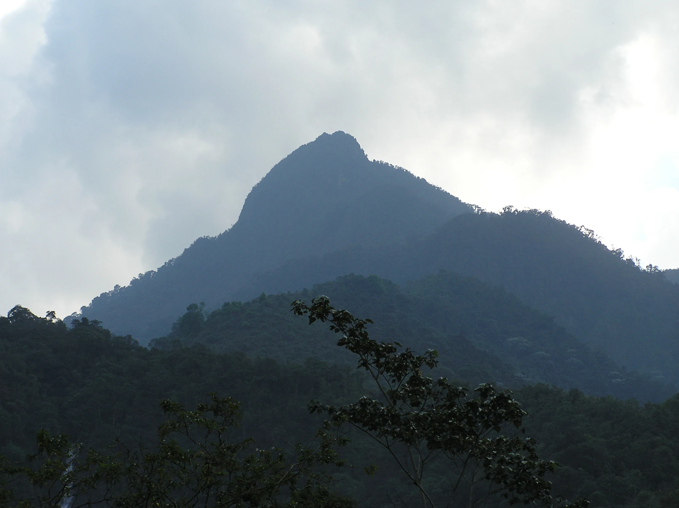
Mountain peak visible through mist with forested terrain in the foreground
Pico de Loro mountain peak viewed through mist with forested terrain in Farallones de Cali National Park

Top sights and standout views in Farallones de Cali

The dramatic summit of Punta Pance at 4,050 meters offers one of the most spectacular viewpoints in the Colombian Andes, with clear days revealing the Pacific coast and port of Buenaventura to the west, the Cauca River valley and Cali to the east, and the Nevado del Huila in the Central Range to the south. The Peñas Blancas area in the Pichindé River valley hosts the famous lek of the Andean cock-of-the-rock, where the brilliant orange males perform elaborate courtship displays. The Anchicayá River watershed represents one of the world's most important birdwatching destinations, supporting exceptional concentrations of species in the Chocó biogeographic region. The cloud forest zone between 1,200 and 2,000 meters creates an otherworldly landscape of fog-draped trees encrusted with epiphytes and mosses. Pico de Loro provides a more accessible summit experience at 2,832 meters with views over Cali and the Cauca Valley.
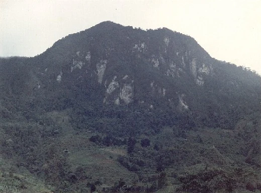
A mountain with rocky cliffs and forested slopes under a cloudy sky
View of Penas Blancas mountain in Farallones de Cali National Park, Colombia

Best time to visit Farallones de Cali

The Farallones de Cali can be visited year-round due to the consistent rainfall patterns that sustain the ecosystems throughout the seasons. The Pacific slope receives approximately 6,000 mm of annual rainfall, while the mountainous sector receives around 2,500 mm, ensuring that water is available in streams and waterfalls in all seasons. The dry season from December to March tends to offer more comfortable hiking conditions in the high elevations, though morning fog is common in the cloud forest zones year-round. The wetter months from April to November bring heavier precipitation but also lusher vegetation and fuller waterfalls. Birdwatching is productive throughout the year, though the Andean cock-of-the-rock displays are most active during the breeding season. Hikers planning summit attempts at Punta Pance should be prepared for rapidly changing conditions regardless of season, as the high-altitude environment can experience cold temperatures, wind, and fog even when the lower slopes are sunny.
Park location guide

Geography guide, regional context, and park location map for Farallones de Cali

Farallones de Cali park geography, regions, and map view in Colombia
Understand where Farallones de Cali sits in Colombia through a broader geographic reading of the surrounding landscape, nearby location context, and its mapped position within the national park landscape.

How Farallones de Cali fits into Colombia

Colombia is a presidential republic located in the northern part of South America. It spans approximately 1.14 million km² and has a population of around 52 million. The country features the Andes mountain range, extensive Amazon rainforest, and coastal regions on both the Caribbean and Pacific. Spanish is the official language, and Bogotá serves as the capital and largest city.

Wider geography shaping Farallones de Cali in Colombia

Colombia is located in the northwestern part of South America, bordering the Caribbean Sea to the north and the Pacific Ocean to the west. Its mainland neighbors are Venezuela to the east, Brazil to the southeast, Peru and Ecuador to the south and southwest, and Panama to the northwest. The terrain is diverse, featuring the Andes mountain range in the west, Amazon rainforest in the south and east, and coastal plains along both oceans.

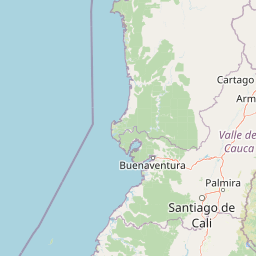
Map view of Farallones de Cali

Use this park location map to pinpoint Farallones de Cali in Colombia, understand its exact geographic position, and read its mapped placement within the surrounding landscape more clearly.

Pigeon | © OpenStreetMap contributors

Location context for Farallones de Cali

Valle del Cauca Department

Visually discover the dramatic mountain terrain, varied ecosystems, and unique protected-area character of Colombia's West Andes.

Farallones de Cali National Park Photos: Exploring Its Diverse Andean Landscapes and Protected Habitats
Browse an immersive visual gallery showcasing the rugged peaks, lush cloud forests, and diverse river valleys of Farallones de Cali National Natural Park. These curated images offer essential insights into the park's dramatic vertical gradient, unique ecosystems from Pacific lowlands to high Andean páramo, and its crucial role in safeguarding Colombia's exceptional biodiversity.

River with white water flowing over rocks surrounded by lush green vegetation

Mountain range with rugged peaks under clear blue sky

Panoramic view of mountain peaks under partly cloudy sky

Misty forest trail surrounded by dense tropical vegetation including ferns, moss-covered branches, and tall trees

Rocky mountain peaks of Punta Pance under a partly cloudy sky with visible rugged terrain and distant clouds

Mountain peak with rocky slopes and dense forest below, viewed from a distance

Mountain peak visible through mist with forested terrain in the foreground

A mountain with rocky cliffs and forested slopes under a cloudy sky

Park atlas

Discover adjacent protected areas and mapped landscapes, tracing the geographic spread of Colombia's Pacific slope and Andean cordillera.

Explore Other National Parks Near Farallones de Cali and the Colombian West Andes
After exploring Farallones de Cali's dramatic peaks and biodiverse ecosystems, browse a curated selection of other national parks and protected areas across the surrounding West Andes and Pacific lowlands. Compare their unique protected landscapes and regional context, deepening your understanding of Colombia's conservation efforts and diverse terrain.
National parkValle del Cauca Department

Uramba Bahía Málaga National Natural Park: National Park Protected Landscape and Geography

Explore mapped natural terrain and protected boundaries.

Gain a detailed atlas understanding of Uramba Bahía Málaga National Natural Park, a designated national park in Colombia's Valle del Cauca Department. This page details its protected landscape features and geographic setting, offering insights into its mapped boundaries and regional context for dedicated geographic exploration.

Area
471 km²
Established
2010
IUCN
II
Climate
Tropical
National parkCauca Department

Munchique National Natural Park: National Park with Key Protected Landscape Features

Explore mapped geography and protected area context.

Munchique National Natural Park is a designated National Park offering a distinct protected landscape within Colombia's Cauca Department. This page provides essential context for understanding its geographic footprint, regional setting, and its significance as a mapped natural area. Dive into the atlas details and explore the unique geography that defines this protected entity.

Area
440 km²
Established
1977
IUCN
II
Relief
Mountain
National parkCauca Department

Puracé National Natural Park: National Park Discovery and Geographic Context in Cauca Department

Explore its mapped protected landscape and regional natural geography.

Puracé National Natural Park offers a rich opportunity for geographic discovery within Colombia's Cauca Department. As a designated national park, its protected landscape serves as a key point of reference for understanding regional natural geography. This atlas-focused entry provides insight into the park's mapped boundaries and its significance as a protected area, facilitating a deeper comprehension of Colombia's conservation territories and natural terrain.

Area
830 km²
Established
1961
IUCN
II
Relief
Mountain
National parkColombia

Tatamá National Natural Park: Colombia's Protected Natural Landscape Explorer

Mapped boundaries and regional geography of a Colombian national park.

Tatamá National Natural Park is a protected natural area situated within the Republic of Colombia. As a designated national park, it contributes significantly to the nation's protected lands. This entry provides essential geographic context, focusing on the park's mapped outlines and its role within the broader atlas of Colombian geography. Understanding Tatamá National Natural Park involves appreciating its specific landscape features and its contribution to the country's network of protected natural areas, offering a foundation for regional geographic study.

Area
519 km²
Established
1987
IUCN
II
Relief
Mountain
National parkColombia

Los Nevados National Natural Park: Colombia's National Park and Protected Landscape

Detailed map context and protected land geography.

Los Nevados National Natural Park serves as a key protected area within Colombia, offering rich opportunities for geographic discovery. This page details the park's mapped boundaries and its contribution to the broader atlas of South American protected lands. Explore the unique landscape character and regional geographic significance that define Los Nevados National Natural Park as a vital natural reserve.

Area
583 km²
Established
1973
IUCN
II
Visitors
39.9K annual
National parkNariño Department

Doña Juana-Cascabel Volcanic Complex National Natural Park: National Park with Mapped Protected Landscape

Explore its volcanic terrain and geographic context in Nariño Department.

Doña Juana-Cascabel Volcanic Complex National Natural Park is a designated National Park offering rich opportunities for geographic exploration. Situated within Nariño Department, this protected landscape provides a unique lens through which to study regional natural features and mapped conservation boundaries. Its presence within Colombia's protected areas network makes it a key point of reference for understanding national park geography and landscape context.

Area
0.267 km²
Established
2007
IUCN
II
Relief
Mountain
National parkColombia

Serranía de Los Churumbelos Auka-Wasi National Natural Park: Colombia's Protected Landscape Atlas

Mapped national park boundaries and regional geography.

Understand Serranía de Los Churumbelos Auka-Wasi National Natural Park through its geographic context and protected landscape features. This atlas view highlights the park's mapped boundaries and its significance within Colombia's natural geography, offering detailed insights into its protected status and regional terrain.

Area
562 km²
Established
2007
IUCN
II
Relief
Mountain
Watercolor illustration of a mountain range with a lake in the foreground, green fields, and a colorful sky
Protected areaColombia

Galeras Protected Area: Exploring Colombia's Mapped Natural Landscapes

Discover the geography and protected terrain of Galeras.

The Galeras protected area in Colombia offers a distinct opportunity for geographic exploration, focusing on its defined boundaries and the natural landscape it encompasses. This resource details the park's setting within the Colombian geography, providing a map-centric view of its protected status. Understanding Galeras contributes to a broader appreciation of protected lands across South America and their unique terrain.

Relief
Mountain
Climate
Alpine
Access
Highly restricted

Common questions about visiting, size, designation, and location context for Farallones de Cali

Farallones de Cali FAQs for park facts, access, geography, and protected area context
Find quick answers about Farallones de Cali, including protected-area facts, park geography, trail and visitor context, and how the park fits into its surrounding country and regional landscape.
MoriAtlas Explorer

Continue Your Protected Areas Search Across the Global Atlas

Deepen your exploration by continuing the structured search for national parks and protected areas worldwide. Utilize the comprehensive filtering capabilities to compare different conservation landscapes and refine your understanding of global park geography. Discover more about the distribution and characteristics of protected natural areas.

Global natural geography