

Mori Atlas logo
Nature reserveFinniss Conservation Park

Mapping the rocky plateaus and ridge-to-valley terrain of this South Australian nature reserve

Finniss Conservation Park and Protected Landscape Geography in the South Mount Lofty Ranges

Finniss Conservation Park represents a significant protected area within the South Mount Lofty Ranges of South Australia. Spanning a high rocky plateau, steep ridges, and deep valleys, this nature reserve preserves an essential remnant of Eucalyptus cosmophylla scrub. The mapped boundaries encompass the Finniss River catchment and provide a vital geographic reference for the surrounding hills landscape.

Mount Lofty Rangessouth Australiaconservation parkEucalyptus cosmophylla scrubsclerophyll scrubregenerating woodland

Finniss Conservation Park

Nature reserve

Park overview

Structured park overview, official facts, and landscape profile for Finniss Conservation Park

Finniss Conservation Park park facts, protected area profile, and essential visitor context

Review the core facts for Finniss Conservation Park, including designation, size, terrain, visitor scale, habitats, and operating context in one park-focused overview.

About Finniss Conservation Park

Finniss Conservation Park is a small but ecologically significant state conservation park in South Australia's Mount Lofty Ranges. Set on elevated terrain west of the small town of Ashbourne and within easy reach of Adelaide, the park protects a representative remnant of the native open forest and scrub vegetation that historically covered large parts of the southern Mount Lofty foothills. Although the park's total area is only about 1.23 square kilometres, the landscape it conserves includes a notable diversity of physical settings, from a high rocky plateau through south-trending ridges and steep intervening valleys to lower valley floor country.

The character of the park is defined above all by its vegetation. The eastern portion of the reserve is occupied by an extensive, very dense and visually spectacular scrub dominated by Eucalyptus cosmophylla, accompanied by species such as Hakea prostrata, Allocasuarina muelleriana, Leptospermum juniperinum and Tetratheca pilosa. This scrub is described as essentially undisturbed and is contiguous with similar vegetation lying to the east and north-east of the park, giving the protected area a meaningful role within a broader habitat landscape. The western end of the park contrasts with this dense scrub and takes the form of Eucalyptus leucoxylon and Eucalyptus fasciculosa woodland that has grown over previously cleared and grazed pasture, now regenerating toward a more natural state.

Beyond its vegetation values, Finniss Conservation Park encompasses a short stretch of the Finniss River, linking the reserve hydrologically to one of South Australia's significant coastal catchments. The crest and ridge locations provide views toward the coast, and the varied topography of crest, slope and valley floor produces a compact but instructive cross-section of the ecological gradients of the southern Mount Lofty Ranges. The park is also a waypoint for long-distance walkers, as the Heysen Trail, one of Australia's iconic extended walking routes, runs along the western side of the conservation park between Ridge Road to the south and Mount Magnificent Road to the north.

Finniss Conservation Park is managed by the South Australian Department for Environment and Water and is recognised at both national and international levels. It is classified as an IUCN Category III protected area and was listed on the former Register of the National Estate in 1980 in recognition of its natural heritage values. The park's enduring significance lies in its capacity to retain a high-quality example of Eucalyptus cosmophylla scrub and associated woodland communities within a landscape that has otherwise been heavily altered by clearance and grazing.

Quick facts and research context for Finniss Conservation Park

Finniss Conservation Park is a state-level protected area in South Australia, located in the Mount Lofty Ranges between Adelaide and the coast near Ashbourne. It was established on 29 January 1976 under the National Parks and Wildlife Act 1972, with later additions in 1985 and 2005 bringing it to a total area of approximately 1.23 square kilometres.

The park is classified as an IUCN Category III protected area and was placed on the former Register of the National Estate in 1980. It is notable for preserving a high-quality remnant of Eucalyptus cosmophylla scrub along with associated woodland and plateau vegetation, and it lies adjacent to the Heysen Trail, which passes along its western boundary.

Protection and recognition

Explore the terrestrial protection scope and documented conservation status for Finniss Conservation Park.

Finniss Conservation Park Protection Status and International Recognition Data

Finniss Conservation Park maintains a documented terrestrial protection scope within its regional landscape. Records outline the established conservation status and available international recognition details for the protected area.

Protection details

Protection scope
Terrestrial
Transboundary protection
No
Park context

Deeper park guide and search-rich context for Finniss Conservation Park

Finniss Conservation Park history, landscape, wildlife, and travel context

Explore Finniss Conservation Park through its history, landscape character, ecosystems, wildlife, conservation priorities, cultural context, and seasonal travel timing in a structured park guide built for atlas discovery and search intent.

Why Finniss Conservation Park stands out

Finniss Conservation Park is especially known for preserving what was described in 1980 as one of the best preserved areas of Eucalyptus cosmophylla scrub in the South Mount Lofty Ranges. This dense, spectacular scrub association dominates the eastern part of the park across a high rocky plateau and forms the core conservation value of the reserve. The park is also recognised for its compact representation of the broader open forest and scrub mosaic typical of the region, encompassing crest, slope and valley floor vegetation associations along with a short stretch of the Finniss River. Together these features make it an important reference site for an increasingly cleared and fragmented hills landscape.
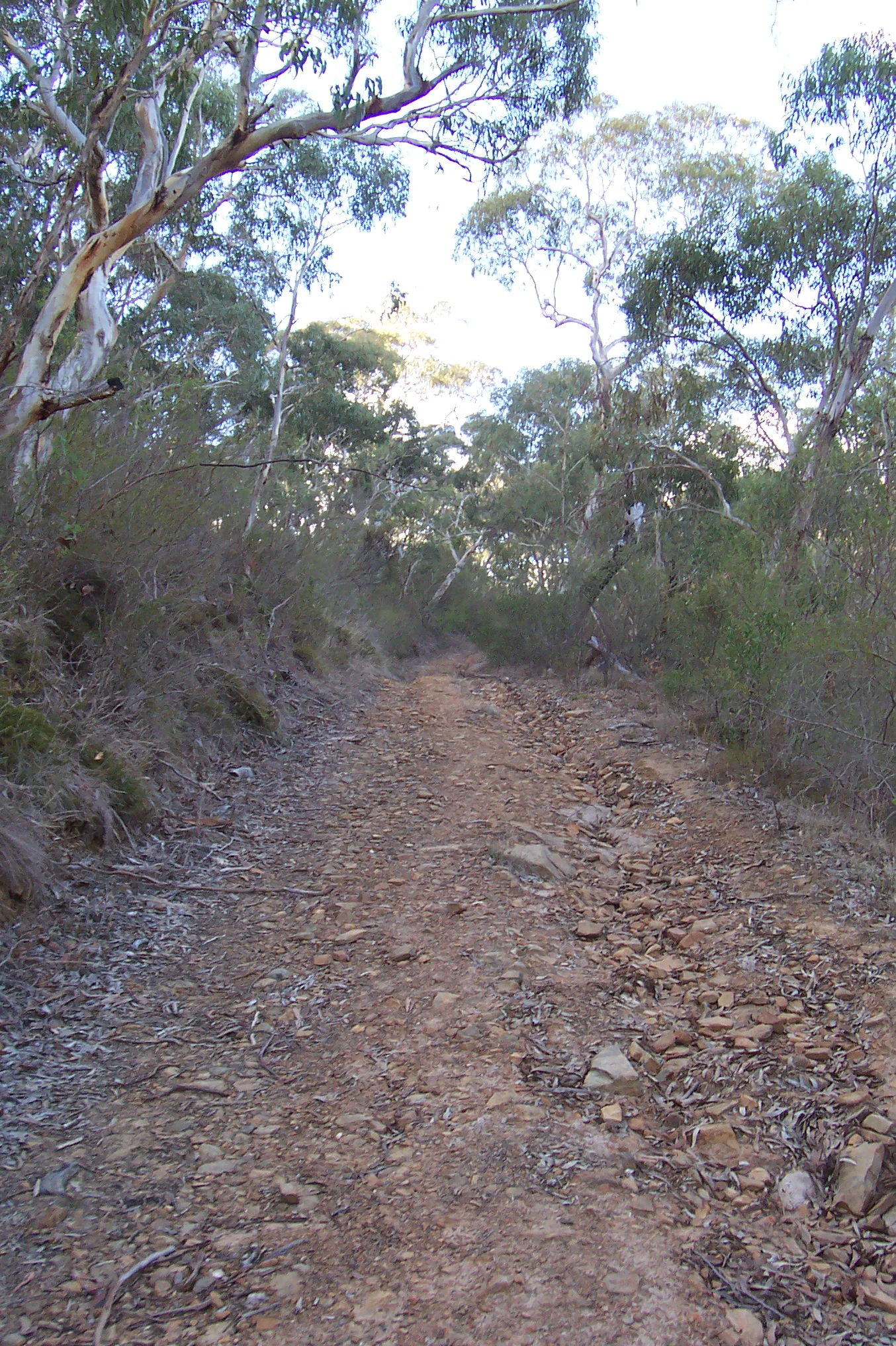
A narrow, unpaved walking trail covered in small loose stones and dry leaves, leading uphill through an open forest of eucalyptus trees with pale bark.
A rugged dirt walking track winding through the open eucalyptus forest of Finniss Conservation Park.

Finniss Conservation Park history and protected-area timeline

Finniss Conservation Park came into existence on 29 January 1976 when the first parcel of land, section 1963 in the Hundred of Kondoparinga, was proclaimed under the National Parks and Wildlife Act 1972. This initial declaration created a small reserve dedicated to preserving a representative sample of the natural open forest and scrub vegetation of the southern Mount Lofty Ranges.

The park was subsequently expanded through two later additions. On 28 November 1985, land in sections 107 and 108 was incorporated into the conservation park, and on 23 June 2005, land in Allotment 22 of DP 63695 was added as well. These additions extended the reserve to its current configuration of about 1.23 square kilometres and broadened the range of habitats it protects, including additional woodland and slope country on the western side.

In 1980, the conservation park was formally recognised for its natural heritage values through inclusion on the Register of the National Estate, a now-defunct national inventory of significant places that reflected the high conservation importance of the Eucalyptus cosmophylla scrub it protected. The 1980 description of the park remains a foundational reference for understanding its landscape, vegetation and ecological character. Under the current South Australian management framework, the park is administered by the Department for Environment and Water and classified as an IUCN Category III protected area.

Finniss Conservation Park landscape and geographic character

Finniss Conservation Park occupies a compact but topographically varied stretch of the southern Mount Lofty Ranges. Its defining physical feature is a high rocky plateau in the eastern part of the park, from which a series of south-trending ridges descend through steep intervening valleys toward lower country. This arrangement of crest, slope and valley floor landforms produces a strongly dissected terrain in a relatively small area and gives the park a sense of much greater size than its footprint suggests.

The elevations and rocky outcrops of the plateau contrast with the gentler slopes and flatter valley floors found elsewhere in the reserve. A short stretch of the Finniss River runs through the park, adding a watercourse element to a landscape otherwise dominated by ridges and scrub. From the higher points, the ridgelines and openings afford views southward toward the nearby coastline, linking the park visually with the broader Gulf St Vincent coastline.

The park sits within the gazetted locality of Mount Magnificent and within the cadastral unit of the Hundred of Kondoparinga, and its linear western boundary is followed closely by the Heysen Trail. The trail corridor runs between Ridge Road in the south and Mount Magnificent Road in the north, defining much of the public experience of the park's western edge and connecting the reserve into the wider walking landscape of the Mount Lofty Ranges.

Finniss Conservation Park ecosystems, habitats, and plant life

The ecological identity of Finniss Conservation Park is built around the open forest and scrub associations of the southern Mount Lofty Ranges, in particular the Eucalyptus cosmophylla dominated communities that occur on its eastern plateau and ridges. This vegetation is considered especially significant for the region because large areas of the surrounding hills landscape have been cleared, grazed or otherwise altered, leaving only fragmented remnants of the original plant cover. The park contains what was described in 1980 as one of the best preserved stands of Eucalyptus cosmophylla scrub in the entire South Mount Lofty Ranges, and the eastern scrub is regarded as essentially undisturbed.

Within that dense scrub, Eucalyptus cosmophylla is accompanied by a suite of characteristic sclerophyllous shrubs and small trees, including Hakea prostrata, Allocasuarina muelleriana and Leptospermum juniperinum. The ground layer and shrub layer also feature Tetratheca pilosa, which contributes to the species-rich heath-like structure typical of soils in this part of the ranges. The combination of these species across crest, slope and valley floor positions produces a layered habitat mosaic where drier ridge tops contrast with slightly more sheltered slope and valley vegetation.

On the western side of the park, the vegetation shifts to an open Eucalyptus leucoxylon and Eucalyptus fasciculosa woodland growing over land that was historically cleared and grazed as pasture. This western woodland is in a regenerating state and reflects the partial recovery of native vegetation on formerly disturbed sites. The juxtaposition of essentially intact scrub on the eastern plateau with regenerating woodland on the western side gives the park particular ecological interest, illustrating both the original character of the regional vegetation and the process by which cleared land can recover toward a more natural state.

Finniss Conservation Park wildlife and species highlights

Finniss Conservation Park's wildlife values are closely tied to the integrity of its native vegetation, in particular the stands of Eucalyptus cosmophylla scrub and adjacent woodland that the reserve was established to protect. These vegetation types provide habitat for the range of small woodland and scrubland birds, mammals, reptiles and invertebrates typical of the southern Mount Lofty Ranges, and the contrast between dense heath-like scrub on the plateau and more open woodland on the slopes supports a varied community of species adapted to different canopy and understorey conditions.

The undisturbed condition of the eastern scrub, together with its continuity with similar habitat beyond the park boundary, makes the reserve an important local refuge for fauna associated with mature native vegetation in a landscape that has otherwise seen extensive modification. The regenerating western woodland adds a secondary habitat layer that supports species able to use younger, more open forest.

The park's position along the Heysen Trail and its proximity to both the coast and the broader Mount Lofty Ranges also places it within a wider landscape used by mobile species, including birds that move between the hills, gorge country and coastal environments of the Fleurieu Peninsula. The Finniss River corridor that runs through part of the park further enhances habitat connectivity for wildlife along the catchment.

Finniss Conservation Park conservation status and protection priorities

Finniss Conservation Park has clear and documented conservation significance within the Mount Lofty Ranges region. Its principal value lies in preserving a high-quality remnant of Eucalyptus cosmophylla scrub and associated open forest and woodland in a landscape that has otherwise experienced extensive vegetation clearance, grazing and fragmentation. By retaining an essentially undisturbed example of this vegetation type, the park helps to safeguard the genetic resources, habitat structure and ecological processes of a community that has become rare at the regional scale.

The reserve's significance has been formally recognised through its classification as an IUCN Category III protected area and through its listing in 1980 on the then-active Register of the National Estate. It also illustrates a layered conservation story, with the eastern scrub representing long-undisturbed habitat and the western woodland showing active regeneration on formerly cleared land, together highlighting both protection and recovery as conservation outcomes.

The park's position adjacent to the Heysen Trail and within a larger matrix of native vegetation to the east and north-east adds to its conservation role by supporting habitat continuity beyond the reserve boundary. Managed by the South Australian Department for Environment and Water under the National Parks and Wildlife Act 1972, it remains a small but meaningful component of the state's network of protected areas in the Mount Lofty Ranges.

Top sights and standout views in Finniss Conservation Park

Finniss Conservation Park is a small but high-quality reserve that protects one of the best preserved remnants of Eucalyptus cosmophylla scrub remaining in the South Mount Lofty Ranges. Its combination of a high rocky plateau, south-trending ridges, steep valleys and a short stretch of the Finniss River produces a striking compact landscape, while the contrast between undisturbed eastern scrub and regenerating western woodland illustrates both the original character and the recovery potential of the regional vegetation.

The park also serves as a waypoint on the Heysen Trail, with its western boundary followed by a section of this long-distance walking route between Ridge Road and Mount Magnificent Road. Its IUCN Category III protection status and former listing on the Register of the National Estate underline its recognised place within South Australia's conservation estate.

Best time to visit Finniss Conservation Park

Given the park's location in the southern Mount Lofty Ranges, visits are most rewarding in the cooler and drier months of late autumn, winter and spring, when temperatures are milder, walking conditions along the nearby Heysen Trail are generally more comfortable, and the sclerophyllous scrub communities are at their freshest. Summer in this part of South Australia can be hot and dry, which can make exposed ridge and plateau sections of the landscape less pleasant to walk and can elevate bushfire risk in the surrounding hills, while the cooler months are typically the most pleasant time to experience the park's vegetation and coastal views at a relaxed pace.

Wildlife, vegetation condition and overall atmosphere can vary subtly with the seasons, but the park's protected vegetation remains a year-round feature. Visitors interested in walking the broader Heysen Trail corridor alongside the park will generally find periods of mild weather and stable soil conditions underfoot the most suitable time to explore the area on foot.

Monthly climate preview

Long-term representative temperature ranges and precipitation patterns in South Australia

Finniss Conservation Park Climate Normals and Monthly Weather Statistics

Representative coordinates record measured monthly temperature swings from warm daytime highs to cooler minimums alongside varying precipitation rates across the year. Detailed monthly climate profiles provide complete twelve month statistical records for comprehensive study.
Annual mean16 °C
11 °C20 °C
Jan20°
Feb20°
Mar19°
Apr17°
May14°
Jun12°
Jul11°
Aug12°
Sep13°
Oct15°
Nov17°
Dec19°
Warmest month
January

20.3 °C

Coolest month
July

11.2 °C

Wettest month
June

2.3 mm/day

Driest month
January

0.6 mm/day

Park location guide

Geography guide, regional context, and park location map for Finniss Conservation Park

Finniss Conservation Park park geography, regions, and map view in Australia

Understand where Finniss Conservation Park sits in Australia through a broader geographic reading of the surrounding landscape, nearby location context, and its mapped position within the national park landscape.

How Finniss Conservation Park fits into Australia

Australia is a constitutional monarchy and federal parliamentary democracy comprising six states and ten territories. With a population of nearly 28 million, it is one of the world's most urbanised countries, with most people concentrated on the eastern seaboard. The country has a high Human Development Index and is known for its cultural diversity, ancient Aboriginal heritage, and unique wildlife.

Wider geography shaping Finniss Conservation Park in Australia

Australia occupies the entire Australian continent, the island of Tasmania, and numerous smaller islands. It is the world's flattest and driest inhabited continent, featuring vast deserts in the interior (the Outback), tropical rainforests along the eastern coast, and a coastline bordering the Indian and Pacific Oceans.

Map view of Finniss Conservation Park

Use this park location map to pinpoint Finniss Conservation Park in Australia, understand its exact geographic position, and read its mapped placement within the surrounding landscape more clearly.

Pigeon | © OpenStreetMap contributors

Location context for Finniss Conservation Park

South Australia
Recorded earthquake history

View Historical Seismic Records for Finniss Conservation Park

Discover the documented history of seismic events associated with the location of Finniss Conservation Park. This catalogue provides a structured view of historical earthquake data as maintained for the Mount Lofty Ranges region, allowing for geographic context across the broader landscape.

Finniss Conservation Park Earthquake History

Catalogued events

4 events

Strongest magnitude

Magnitude 4

Most recent event

Mar 29, 2022

This history includes earthquakes recorded inside the park or within 50 km of its borders

Visualizing the high rocky plateau, scrub habitats, and ridgeline terrain

Finniss Conservation Park Photos and Protected Area Landscape Scenery

Examine detailed photography highlighting the rugged topography, native Eucalyptus scrub, and protected valley habitats within Finniss Conservation Park. Visual records reveal the distinct physical character of the South Mount Lofty Ranges and the surrounding conservation landscape.

A narrow, unpaved walking trail covered in small loose stones and dry leaves, leading uphill through an open forest of eucalyptus trees with pale bark.

Park atlas

Discover related national parks and connected conservation terrain across the southern Mount Lofty Ranges

Explore Protected Areas Near Finniss Conservation Park and Surrounding Regional Landscapes

Browse other protected areas and regional reserves connected to the unique vegetation patterns of Finniss Conservation Park. Compare nearby park geography to understand the broader conservation mosaic defining the South Australian hills landscape.
Nature reserveSouth Australia
0.7 km away#1 closest

Southeast

Cox Scrub Conservation Park: Protected Sandy Heaths and Eucalyptus Forests in South Australia

A rare, minimally disturbed nature reserve in the Mount Lofty Ranges

Cox Scrub Conservation Park functions as a significant botanical reference point, preserving an unusual habitat of low open forest and heathland on nutrient-poor sandy soils. This South Australian nature reserve offers an intact look at the transition zone between ranges and coastal plains, supporting diverse bird species within its protected borders.

Area
5.44 km²
Established
1970
IUCN
III
Relief
Upland
Nature reserveSouth Australia
About 8.6 km away#2 closest

East

Bullock Hill Conservation Park: Protected Eucalypt Woodland and Terrain Map

Natural reserves and regional geography in South Australia

Bullock Hill Conservation Park features a 188-metre landmark hill surrounded by native eucalypt forest and acacia-rich woodland. This protected area represents a vital slice of regional geography in the southern foothills of the Mount Lofty Ranges, providing a focused example of local biodiversity and preserved natural terrain within a rural landscape.

Area
2.21 km²
Established
2014
IUCN
III
Relief
Upland
National parkSouth Australia
18 km away#3 closest

Northwest

Onkaparinga River National Park: National Park Protected Landscape in South Australia

Explore mapped boundaries and regional geographic context.

Onkaparinga River National Park is a designated national park within South Australia, offering a focused point for understanding protected landscapes. This entry provides detailed geographic context, highlighting the park's mapped boundaries and its place within the regional atlas. Engage with the specific geography and protected-area identity of Onkaparinga River National Park to enhance your landscape exploration.

Area
15.42 km²
Established
1993
IUCN
II
Relief
Upland
Nature reserveSouth Australia
About 19 km away#4 closest

Southwest

Gum Tree Gully Conservation Park: Protected Habitat and Landscape Geography

Nature reserve within the southern Mount Lofty Ranges

This nature reserve in South Australia protects a specific gully system within the Hindmarsh Tiers. Established as a focal point for the recovery of the endangered southern emu-wren, the park preserves a remnant bushland pocket that is vital for regional biodiversity conservation and landscape mapping.

Area
1.11 km²
Established
2010
IUCN
III
Climate
Mediterranean
National parkSouth Australia
24 km away#5 closest

Southeast

Coorong National Park: South Australia National Park Mapped Boundaries and Landscape Context

Explore its unique protected landscape and regional geography.

Coorong National Park in South Australia is featured here as a key protected area for geographic discovery. Users can explore the park's specific landscape characteristics, mapped boundaries, and its role within the regional geography of South Australia. This detail page supports an atlas-based understanding of protected lands, offering a focused perspective on the park's natural terrain and conservation significance within Australia.

Area
490.15 km²
Established
1967
IUCN
II
Relief
Lowland
National parkSouth Australia
29 km away#6 closest

Northwest

Glenthorne National Park, Ityamaiitpinna Yarta: Exploring South Australia's National Park Geography

Understand the park's protected landscape and mapped context.

Glenthorne National Park, Ityamaiitpinna Yarta represents a key protected area within South Australia, offering focused insights into its geographic placement and landscape characteristics. As a national park, it serves as an important entity for understanding regional natural landscapes and the mapped distribution of protected lands across the state. Explore its specific context within South Australia's broader geography.

Established
2020
Scope
Terrestrial
Water
Minor water
National parkSouth Australia
32 km away#7 closest

North

Belair National Park National Park: South Australia Protected Landscape and Map Exploration

Explore the geographic context and mapped boundaries of this South Australian protected area.

Belair National Park represents a significant protected land entity within South Australia, offering specific geographic insights relevant to atlas exploration. As a designated national park, its mapped boundaries and landscape character are essential for understanding regional conservation efforts. This profile provides foundational information on the park's identity as a protected natural area, anchoring its position within the geography of South Australia for detailed map-based discovery and regional context.

Area
8.35 km²
Established
1891
IUCN
II
Visitors
358.6K annual
National parkAdelaide Hills
About 38 km away#8 closest

North

Cleland National Park: Mapped Protected Landscape and Regional Geographic Context

Discover the natural terrain and park boundaries within Adelaide Hills.

Cleland National Park offers a critical lens into the protected landscapes of South Australia's Adelaide Hills. As a national park, its mapped boundaries and geographic position are key elements for understanding regional natural terrain. This resource facilitates atlas-style exploration of Cleland National Park, highlighting its importance within the conservation framework and providing a foundation for detailed geographic study.

Area
11.25 km²
Established
1945
IUCN
II
Visitors
100K annual

Common questions about visiting, size, designation, and location context for Finniss Conservation Park

Finniss Conservation Park FAQs for park facts, access, geography, and protected area context

Find quick answers about Finniss Conservation Park, including protected-area facts, park geography, trail and visitor context, and how the park fits into its surrounding country and regional landscape.
MoriAtlas Explorer

Continue Your Protected Areas Search Across the Global Atlas

Deepen your exploration by continuing the structured search for national parks and protected areas worldwide. Utilize the comprehensive filtering capabilities to compare different conservation landscapes and refine your understanding of global park geography. Discover more about the distribution and characteristics of protected natural areas.

Global natural geography