Mori Atlas logo
Protected landscapeFire Island National Seashore

Understanding the unique barrier island systems and maritime forest ecology of this protected wilderness

Fire Island National Seashore: Mapped Geography and Protected Coastal Landscape in New York

Fire Island National Seashore preserves twenty-six miles of a dynamic barrier island system off the southern coast of Long Island. This protected landscape encompasses shifting dunes, salt marshes, and the rare maritime canopy of the Sunken Forest. As the location of the only federally designated wilderness area in New York State, the park provides an essential look at the evolving coastal processes, tidal inlets, and fragile ecosystems that define this narrow Atlantic coastline.

barrier islandAtlantic coastbeach and dunesmaritime forestsalt marshwilderness area

Fire Island National Seashore

Protected landscape

Park overview

Structured park overview, official facts, and landscape profile for Fire Island National Seashore

Fire Island National Seashore park facts, protected area profile, and essential visitor context

Review the core facts for Fire Island National Seashore, including designation, size, terrain, visitor scale, habitats, and operating context in one park-focused overview.

About Fire Island National Seashore

Fire Island National Seashore is a federal coastal reserve that anchors the human and natural story of one of America's most recognizable barrier islands. The park stretches across most of Fire Island, a long, slim ribbon of sand paralleling the southern shore of Long Island in Suffolk County, New York. It is bordered on one side by the Atlantic Ocean and on the other by the Great South Bay, a broad lagoon that has shaped the island's quiet, sheltered character since long before the park existed.

At its core, the seashore is a place where the dynamics of wind, tide, and shifting sand are the leading characters. Beach, dune, and maritime forest ecosystems line up in a narrow but rich ecological sequence, supporting wildlife that has adapted to the specific challenges of barrier-island life. The Atlantic side offers long, ocean-facing beaches and dramatic surf, while the bay side connects to calmer waters, marinas, and the small private communities that have grown up inside the park's boundaries over many decades.

The park's distinctiveness comes from the way it combines multiple experiences within a surprisingly compact geography. In the west, near Robert Moses State Park, visitors find the Fire Island Lighthouse, broad beaches, and accessible day-use areas. Toward the middle, Sailor's Haven anchors the unusual Sunken Forest ecosystem, a dense maritime holly and oak woodland protected behind a boardwalk trail. In the east, the Otis Pike Fire Island High Dune Wilderness preserves the island's interior in its most natural state, with grassy wetlands, dune ridges, and pine forest that feel far removed from urban New York despite being only a short distance away.

Access is part of Fire Island's identity. Only two road connections cross to the island, and there are no public roads within the seashore itself. Bridge access serves the western end through the Robert Moses Causeway, while the William Floyd Parkway serves the east. Ferries and private boats from communities along the Long Island mainland, including Patchogue, Sayville, and Bay Shore, provide the other main routes onto the island. This limited access helps preserve the quiet, walkable character that defines much of the park.

Fire Island National Seashore is also a place with layered human history. Seventeen private communities, including well-known names like Saltaire, Fire Island Pines, and Ocean Beach, are embedded within the park's boundaries, reflecting more than a century of seasonal and residential coastal life. A separate unit on Long Island protects the William Floyd House, the historic estate of a Revolutionary War general and signer of the Declaration of Independence. The Fire Island Lighthouse stands as an enduring maritime landmark, while local folklore around pirate shipwrecks and lighthouse legends adds a cultural thread to the natural setting, making the seashore both an ecological and a place-based experience.

Quick facts and research context for Fire Island National Seashore

Fire Island National Seashore lies off the south shore of Long Island in Suffolk County, New York, and protects about twenty-six miles of Fire Island, a narrow Atlantic barrier island separated from the mainland by the Great South Bay. It was established on September 11, 1964, and is administered by the National Park Service under IUCN protected landscape and seascape status.

The seashore encompasses ocean beaches, dune systems, interior pine forest, salt marsh, and the Otis Pike Fire Island High Dune Wilderness, which is the only federally designated U.S. wilderness area in New York. Within its boundaries are seventeen private communities, two causeway access points, the historic Fire Island Lighthouse, the Sailor's Haven visitor area, and the separately managed William Floyd House estate on Long Island.

Protection and recognition

Documented protection parameters and official designation records for Fire Island National Seashore

Fire Island National Seashore Protection Status and Terrestrial Management Scope

Fire Island National Seashore maintains a documented terrestrial protection scope within its designated conservation framework. Official records outline the established management scope and administrative recognition parameters for the protected area.

Protection details

Protection scope
Terrestrial
Transboundary protection
No
Park context

Deeper park guide and search-rich context for Fire Island National Seashore

Fire Island National Seashore history, landscape, wildlife, and travel context

Explore Fire Island National Seashore through its history, landscape character, ecosystems, wildlife, conservation priorities, cultural context, and seasonal travel timing in a structured park guide built for atlas discovery and search intent.

Why Fire Island National Seashore stands out

Fire Island National Seashore is best known for its long, undeveloped Atlantic oceanfront beaches set along a narrow barrier island just off Long Island. The park encompasses the only federally designated wilderness area in New York State, the Otis Pike Fire Island High Dune Wilderness, where shifting dunes, pine forest, and salt marsh habitats support piping plovers, herons, white-tailed deer, and migratory waterfowl. It is equally recognized for the unusual Sunken Forest at Sailor's Haven, a unique maritime holly and oak community growing beneath tall canopy trees inside the island's interior. The historic Fire Island Lighthouse, the limited-access character of the island reached only by bridge or ferry, and the diverse barrier-island habitats within a short distance from a major metropolitan area give Fire Island National Seashore a distinctive profile among U.S. coastal parks.
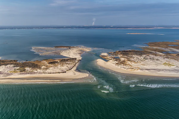
Aerial view of a breach in a sandy barrier island, showing water flowing from the open ocean into a sheltered bay.
An aerial view of the wilderness breach at Old Inlet, illustrating the dynamic barrier island environment of Fire Island National Seashore.

Fire Island National Seashore history and protected-area timeline

Fire Island National Seashore was established as a unit of the United States National Park Service on September 11, 1964. Its creation reflected a growing national recognition during the mid-twentieth century that unprotected stretches of American coastline were being rapidly developed and that key natural and recreational values of barrier islands needed to be preserved through federal action.

Long before the park existed, Fire Island had already developed a layered human story shaped by private communities, maritime activity, and lighthouse operation. Within the seashore's boundaries, seventeen private communities, including Saltaire, Fire Island Pines, and Ocean Beach, had taken shape over prior decades. The Fire Island Lighthouse, near the western end of the island, had stood for generations as a major navigational aid for vessels moving along the mid-Atlantic coast.

An important early chapter in the park's identity came with the William Floyd House, a separate unit of Fire Island National Seashore located on Long Island in Mastic Beach. The house and estate belonged to William Floyd, a general in the American Revolutionary War and a signer of the Declaration of Independence. The property is listed on the National Register of Historic Places, giving the seashore a direct tie to the founding era of the United States.

A defining protective milestone for the park came in 1980, when the United States Congress designated the Otis Pike Fire Island High Dune Wilderness Area. Named for former New York Congressman Otis G. Pike, who co-sponsored the bill creating Fire Island National Seashore and worked to secure its passage, the wilderness area strengthened the seashore's conservation profile. It also created the only federally designated U.S. wilderness area in New York State, anchoring the eastern end of the seashore as a quiet, wild refuge.

The early twenty-first century brought new attention to the dynamic nature of barrier islands when Hurricane Sandy struck in October 2012. The storm's powerful tides opened a major breach at Old Inlet on the edge of the wilderness area, dramatically reshaping that part of the island. Rather than immediately close the breach, park officials chose a course of monitoring and natural evolution, a decision that allowed the opening to refresh water quality in Great South Bay before the breach eventually closed on its own roughly twelve years after the storm. This response, alongside long-running management of fragile habitats like piping plover nesting areas, has shaped the modern history of Fire Island National Seashore as a place where active stewardship and natural processes work hand in hand.

Fire Island National Seashore landscape and geographic character

Fire Island's landscape is defined by its identity as a long, narrow Atlantic barrier island, roughly thirty miles in total length but averaging only about half a mile in width. The park spans twenty-six miles of this corridor along the south shore of Long Island. On one side lies the open Atlantic Ocean, and on the other lies the Great South Bay, the broad lagoon that separates the island from the mainland.

The terrain runs through several distinct physical zones from ocean to bay. Open ocean beaches line the seaward side, often broad and backed by high dune ridges that have built up over centuries of wind and tide action. Inland from the dunes, the island's interior transitions into a mosaic of maritime pine forest, low scrub, and grassy wetlands, including, at Sailor's Haven, the unusual protected canopy woodland known as the Sunken Forest. Toward the bay side, salt marshes and tidal flats create a softer edge, with quieter waters and sheltered habitat.

The Otis Pike Fire Island High Dune Wilderness preserves the park's most dramatic dune topography and least developed interior. Within the wilderness area, dune ridges reach significant heights, supporting pine forest and grassy wetland communities that occupy the natural high ground and low swales of the island system. The wilderness does not formally include the ocean-facing beaches, leaving them as a separate functional zone along the shoreline.

Dynamic change is a defining feature of Fire Island's landscape. Barrier islands are inherently shifting, and Fire Island has been reshaped repeatedly by major storms. The Old Inlet breach, opened by Hurricane Sandy in 2012, was a vivid illustration of this constant transformation, creating a temporary direct connection between the Atlantic and the Great South Bay and altering tidal flow, sand movement, and bay-side conditions for years before eventually closing again. The landscape therefore feels less like a fixed postcard and more like an evolving coastal system, where dunes rebuild, inlets open and close, and the line between ocean and bay shifts over time.
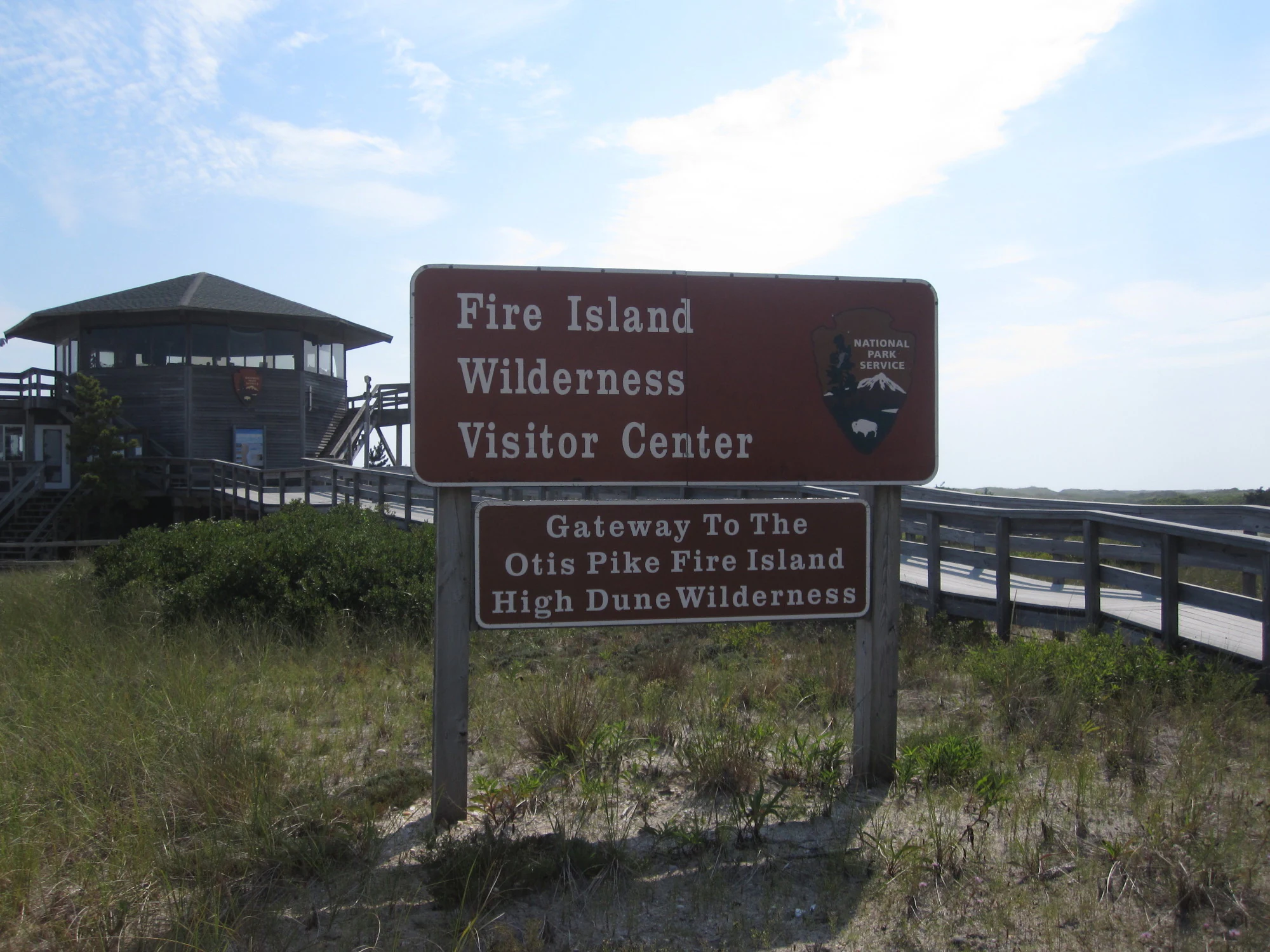
A brown National Park Service sign identifying the Fire Island Wilderness Visitor Center and the entrance to the Otis Pike Fire Island High Dune Wilderness, with the wooden visitor center building in the background.
The entrance sign for the Fire Island Wilderness Visitor Center, marking the gateway to the Otis Pike Fire Island High Dune Wilderness.

Fire Island National Seashore ecosystems, habitats, and plant life

Fire Island National Seashore protects a remarkable compact sequence of barrier-island ecosystems. The most visually dominant habitats are the oceanfront beaches and the dune systems that rise behind them, shaped continually by wind, tide, and storm activity. These dunes are a defining ecological feature, anchoring the island's shape and providing one of its signature landscapes.

Inland from the dunes, the island supports a maritime pine forest, low heathlands, and grassy wetland communities. One of the park's most distinctive ecological sites is the Sunken Forest at Sailor's Haven, a unique woodland community dominated by American holly, sassafras, and oaks growing beneath a tall wind-protected canopy. This rare forest type reflects the unusual microclimate of the island's interior and is one of the key natural attractions of the park.

Toward the bay side, salt marsh and tidal flat habitats line the shore, supporting a different set of species adapted to brackish, sheltered conditions. These marshes play an important role in filtering water that reaches the Great South Bay and provide feeding grounds for fish, shorebirds, and migratory species that move through the region during the year. The contrast between the dynamic ocean side and the calmer bay side gives the park a layered ecological identity that is unusual for such a narrow island.

Fire Island National Seashore wildlife and species highlights

Fire Island National Seashore's wildlife reflects the specialized conditions of barrier-island living. Perhaps the most widely recognized species of concern is the piping plover, a small shorebird that nests on the island's open sandy beaches. Because plovers depend on exactly this kind of habitat, the park's dune-and-beach systems are critical to their survival, and seasonal protection measures shape how visitors experience some stretches of shoreline during nesting months.

The island is also important for herons, terns, and migratory waterfowl, which use the Great South Bay shoreline, the interior wetlands, and the salt marsh edge as feeding and resting habitat during seasonal movements. The bay's sheltered waters, in turn, support a recovery of fish and shellfish populations following storm-driven changes in water quality, illustrating how dynamic barrier islands can be for marine life as well as for birds.

On land, white-tailed deer are a visible presence in the wilderness and forested areas of the island. Smaller mammals, reptiles, and a wide range of migratory songbirds also pass through the park during the year, taking advantage of the maritime forest and dune-edge communities as stopover habitat along the Atlantic Flyway.

Fire Island National Seashore conservation status and protection priorities

Fire Island National Seashore carries strong conservation significance because it preserves a representative stretch of a major Atlantic barrier island within a densely populated coastal region of the northeastern United States. By protecting twenty-six miles of Fire Island, the park ensures that natural dune, beach, and interior habitats persist between Manhattan and the open ocean, providing a refuge for wildlife and a benchmark for understanding how barrier islands function.

The Otis Pike Fire Island High Dune Wilderness raises the park's conservation profile substantially. As the only federally designated U.S. wilderness area in New York State, it carries the highest level of habitat protection available under American land conservation law, limiting development and ensuring that the island's least disturbed ecosystems remain intact. The wilderness preserves dune ridges, maritime pine forests, and grassy wetlands that support sensitive species including piping plovers, which nest on the surrounding beaches.

Conservation management at Fire Island also involves active stewardship of dynamic coastal processes. The response to Hurricane Sandy's Old Inlet breach, in which officials chose monitoring and natural evolution over immediate closure, showed how the National Park Service integrates scientific understanding of coastal systems with local concerns about flooding, water quality, and bay ecology. The breach's eventual reopening of bay habitats to fish and shellfish recolonization, before the inlet closed again years later, became a real-world example of how natural processes can support ecological recovery on barrier islands.

Fire Island National Seashore cultural meaning and human context

Fire Island has a rich human and cultural story layered on top of its natural setting. The island has long been associated with maritime life, including fishing, lighthouse keeping, and the lore of shipwrecks and piracy along the Long Island coast. Fires lit for ship navigation and salvage activity may have inspired both the island's name and long-running legends of lost treasure, themes that remain part of local folklore today.

The Fire Island Lighthouse, located near the western end of the seashore, is a focal point of this maritime heritage. Stories of a grieving lighthouse keeper and his daughter, and later media coverage of paranormal investigations at the site, reflect how the island's maritime past continues to shape its cultural identity. The lighthouse itself is a prominent landmark in park imagery and an enduring symbol of the coast.

The William Floyd House, a separate unit of Fire Island National Seashore located on Long Island in Mastic Beach, adds another cultural layer. As the home and estate of William Floyd, a Revolutionary War general and signer of the Declaration of Independence, the property is listed on the National Register of Historic Places and ties the park directly to the founding era of the United States. Within the seashore's main boundaries, seventeen private communities such as Saltaire, Fire Island Pines, and Ocean Beach also reflect over a century of seasonal and residential coastal culture on Long Island's south shore.

Top sights and standout views in Fire Island National Seashore

Fire Island National Seashore stands out for the way it places sweeping ocean beaches, high dunes, maritime forest, salt marsh, and the only federally designated wilderness area in New York State within the footprint of a single long, narrow barrier island. The Sunken Forest at Sailor's Haven is one of the park's most unique natural attractions, offering an accessible walk through a rare maritime holly and oak community beneath a tall canopy.

The historic Fire Island Lighthouse and the William Floyd House estate connect the park to both America's maritime navigation history and its founding era. The limited-access character of the island, reached only by two bridges or by ferry, leaves much of Fire Island quieter and more walkable than most other coastal recreation areas in the region, reinforcing the sense that this is a place where barrier-island natural systems and traditional coastal life coexist.

Best time to visit Fire Island National Seashore

Spring through fall is broadly the most rewarding window for a visit to Fire Island National Seashore, when beach, dune, and forest environments are active and accessible. In late spring and summer, the park comes alive with day-trip and ferry access, public beaches are at their busiest, and ranger programs and visitor centers are typically in full operation. The maritime forest and the Sunken Forest are most comfortable to explore in mild weather, while bay-side communities ease into their busiest seasonal rhythms.

Late spring and early summer are also the most sensitive period for beach-nesting wildlife such as the piping plover, and parts of the shoreline may be temporarily managed to protect nesting areas. Fall brings cooler temperatures, fewer crowds, and often dramatic ocean and dune scenery shaped by late-season weather. Winter visitation is generally quieter, with some services and facilities reduced, though the island's stark landscape, low light over the dunes, and the Fire Island Lighthouse still hold a particular appeal for visitors seeking solitude on the coast.

Monthly climate preview

Long term monthly temperature and precipitation averages for New York

Fire Island National Seashore Climate Normals and Temperature Rhythms

Fire Island National Seashore exhibits measured annual temperature variations spanning from sub zero winter minimums to warm summer maximums alongside steady daily precipitation rates. Reviewing the complete twelve month dataset provides granular monthly normals for detailed park research and comparative regional analysis.
Annual mean12 °C
2 °C23 °C
Jan
Feb
Mar
Apr
May13°
Jun19°
Jul23°
Aug23°
Sep20°
Oct15°
Nov10°
Dec
Warmest month
August

23.1 °C

Coolest month
February

2 °C

Wettest month
December

4.2 mm/day

Driest month
May

3.1 mm/day

Park location guide

Geography guide, regional context, and park location map for Fire Island National Seashore

Fire Island National Seashore park geography, regions, and map view in United States of America

Understand where Fire Island National Seashore sits in United States of America through a broader geographic reading of the surrounding landscape, nearby location context, and its mapped position within the national park landscape.

How Fire Island National Seashore fits into United States of America

The United States of America is a federal presidential republic and one of the world's largest countries by area and population. It consists of 50 states across a vast territory spanning multiple time zones, with its capital in Washington, D.C. and largest city in New York City. The nation has a diverse economy, influential political system, and significant cultural and military presence globally.

Wider geography shaping Fire Island National Seashore in United States of America

The United States occupies a vast territory in North America, bordered by Canada to the north and Mexico to the south. The 48 contiguous states stretch from the Atlantic to the Pacific Ocean, while Alaska occupies the northwestern region and Hawaii is an archipelago in the Pacific. The country encompasses diverse terrain including the Rocky Mountains, Appalachian Mountains, Great Plains, and extensive river systems.

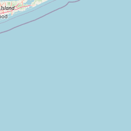
Map view of Fire Island National Seashore

Use this park location map to pinpoint Fire Island National Seashore in United States of America, understand its exact geographic position, and read its mapped placement within the surrounding landscape more clearly.

Pigeon | © OpenStreetMap contributors

Location context for Fire Island National Seashore

New York
Recorded earthquake history

Examine the Recorded Earthquake History of Fire Island National Seashore

Consult the historical seismic catalogue for Fire Island National Seashore to review past earthquake records and epicentre data. MoriAtlas provides these documented events as a resource for understanding regional seismic activity through a geographic lens.

Fire Island National Seashore Earthquake History

Catalogued events

1 event

Strongest magnitude

Magnitude 3.8

Most recent event

Oct 21, 1981

This history includes earthquakes recorded inside the park or within 50 km of its borders

Visual reference for barrier island terrain, coastal dunes, and maritime forest habitats

Fire Island National Seashore Photos, Landscapes, and Protected Scenery

Visual records capture the shifting topography, high dunes, and marine habitats that define Fire Island National Seashore. Photographic documentation reveals the protected coastal environment, from open Atlantic beaches to the sheltered interior of the Sunken Forest.

Aerial view of a breach in a sandy barrier island, showing water flowing from the open ocean into a sheltered bay.

A view of the Fire Island Lighthouse with a black and white tower, connected to a visitor building, accessed by a wooden boardwalk winding through tall green grasses under a clear blue sky.

A brown National Park Service sign identifying the Fire Island Wilderness Visitor Center and the entrance to the Otis Pike Fire Island High Dune Wilderness, with the wooden visitor center building in the background.

Park atlas

Compare regional protected areas and connected barrier island geography.

Explore Parks Near Fire Island National Seashore And Surrounding Coastal Landscapes

Browsing protected areas near Fire Island National Seashore reveals diverse coastal ecosystems and shifting Atlantic shoreline geography. Evaluating adjacent regional parks provides valuable context for understanding barrier island habitats and marine conservation corridors.
Watercolor painting of a light, abstract landscape featuring green fields, soft hills in the background, and touches of pink and yellow vegetation.
Protected landscapeNew York
46 km away#1 closest

West

Gateway National Recreation Area: A Mapped Guide to Coastal Protected Landscapes

Urban coastal geography and maritime heritage sites

Spanning from the western Rockaway Peninsula to the shores of New Jersey, Gateway National Recreation Area serves as a major ecological anchor. This protected landscape integrates rare maritime habitats, barrier beach systems, and decommissioned military installations into a singular geographic footprint. Use this atlas resource to understand the park's three primary units and their roles in maintaining the natural shoreline of the New York Harbor region.

Area
107.67 km²
Established
1972
IUCN
V
Visitors
8.7M annual
Watercolor illustration depicting a cascading waterfall nestled between rolling green hills and a gentle body of water.
Protected landscapeUnited States of America
146 km away#2 closest

West

Delaware Water Gap National Recreation Area: Regional Geography and Mapped Protected Landscapes

Appalachian river corridors and mountain pass geography.

Delaware Water Gap National Recreation Area serves as a major protected unit in the United States, centered on the dramatic geological pass where the Delaware River cuts through Kittatinny Mountain and Blue Mountain. This expansive landscape preserves critical riverine habitats, forested ridges, and historic corridors that provide a deep look into the regional geography of the mid-Atlantic Appalachians.

Area
270.09 km²
Established
1965
Visitors
4.2M annual
Relief
Mountain
Marine protected areaRhode Island
About 148 km away#3 closest

Northeast

Narragansett Bay National Estuarine Research Reserve: Island and Marine Protected Area Overview

A coastal research landscape in Rhode Island

Discover the geographic composition of the Narragansett Bay National Estuarine Research Reserve. This marine protected area spans the terrestrial and aquatic zones of three major islands within the Narragansett Bay system, providing a deep look at estuarine habitat conservation and regional island geography.

Area
15.9 km²
Established
1980
Relief
Lowland
Climate
Temperate
Nature reserveNew Jersey
About 149 km away#4 closest

Southwest

Jacques Cousteau National Estuarine Research Reserve: New Jersey Coastal Protected Area

Inland-to-ocean ecological gradient map and landscape overview.

Located in southeastern New Jersey, the Jacques Cousteau National Estuarine Research Reserve provides a rare, contiguous protected footprint covering the Mullica River and Great Bay. This landscape includes freshwater swamps, salt marshes, and barrier island dunes, offering a benchmark site for scientific research on estuarine and coastal processes along the Atlantic coast.

Area
470 km²
Established
1997
Relief
Lowland
Climate
Temperate
Watercolor painting of a lush green landscape featuring rolling hills in the distance, a meandering stream in the midground, and wetlands with cattails in the foreground.
Protected landscapeVermont
219 km away#5 closest

North

Green Mountain National Forest: Mapped Geography and Protected Landscape Analysis

Examining the wilderness backbone of Vermont's mountainous terrain

Gain insight into the expansive boundaries of Green Mountain National Forest, an essential protected area spanning the Green Mountains of Vermont. This profile details the forest's composition, ranging from high-elevation spruce-fir zones to mixed hardwood slopes and extensive federal wilderness corridors, providing a foundational geographic understanding of this vital northeastern landscape.

Area
1,615.31 km²
Established
1932
Relief
Mountain
Climate
Temperate
A watercolor painting of a green, rolling coastal landscape with gentle hills and trees under a white background.
Protected landscapeMassachusetts
About 228 km away#6 closest

Northeast

Boston Harbor Islands National and State Park: Mapping Coastal Protected Landscapes

A diverse archipelago of islands and tidal harbors in Massachusetts

Boston Harbor Islands National and State Park offers an expansive look at coastal geography within the Massachusetts Bay. Spanning dozens of islands and peninsulas, this protected landscape captures a blend of drumlin terrain, tidal salt marshes, and historic maritime structures set directly against the urban skyline of Boston.

Area
6 km²
Established
1996
Visitors
28.2K annual
Relief
Lowland
Wildlife reserveBennington County
229 km away#7 closest

North

George D. Aiken Wilderness: Protected Forest Landscapes and Ridgelines in Vermont

Detailed geographic overview of a Green Mountain wilderness reserve

Spanning over 4,800 acres in Bennington County, the George D. Aiken Wilderness stands as a significant protected area within the southern Green Mountains. The terrain features narrow ridgelines, steep valleys, and a dense canopy of northern hardwoods that remain unmanaged to maintain wilderness standards. This area serves as a primary geographic anchor for Eastern wilderness preservation efforts in the United States.

Area
19 km²
Established
1984
IUCN
Ib
Relief
Mountain
A horizontal watercolor painting depicting a winding river flowing through a lush, forested valley with rolling hills in the background.
Wildlife reserveVermont
253 km away#8 closest

North

Lye Brook Wilderness: Protected High Plateau and Forest Geography in Southern Vermont

Mapped wilderness boundaries within the Green Mountain National Forest

Spanning nearly 18,000 acres, Lye Brook Wilderness offers a deep dive into southern Vermont's natural geography. The area features a high forested plateau, complex brook valleys, and elevated ridgelines that characterize this established wilderness reserve. Ideal for those studying the regional landscape and its protected ecosystem, this record provides essential context on the forest cover, glacial terrain, and the geographic significance of this Vermont backcountry unit.

Area
73.34 km²
Established
1975
IUCN
Ib

Common questions about visiting, size, designation, and location context for Fire Island National Seashore

Fire Island National Seashore FAQs for park facts, access, geography, and protected area context

Find quick answers about Fire Island National Seashore, including protected-area facts, park geography, trail and visitor context, and how the park fits into its surrounding country and regional landscape.
MoriAtlas Explorer

Continue Your Protected Areas Search Across the Global Atlas

Deepen your exploration by continuing the structured search for national parks and protected areas worldwide. Utilize the comprehensive filtering capabilities to compare different conservation landscapes and refine your understanding of global park geography. Discover more about the distribution and characteristics of protected natural areas.

Global natural geography