
Mori Atlas logo
Nature reserveFlutgrabenaue Waltersdorf

A preserved lowland floodplain ecosystem showcasing traditional Mark Brandenburg marshland character.

Flutgrabenaue Waltersdorf Nature Reserve: Mapped Protected Landscapes in Brandenburg Germany

(Naturschutzgebiet Flutgrabenaue Waltersdorf)

Flutgrabenaue Waltersdorf serves as a critical nature reserve situated within the Dahme-Spreewald district of Brandenburg. This protected area encompasses a 4.5 kilometer stretch of the Flutgraben waterway, preserving a mosaic of reed beds, alder swamp forests, and wet meadows shaped by historical glacial meltwater patterns. By functioning as a remnant of traditional lowland countryside, the reserve maintains essential wetland habitats amidst the growing suburban density of the surrounding Berlin metropolitan region.

wetlandfloodplainnature reservelowland meadowswet meadowsreed beds
A colorful digital illustration showing a winding river flowing through a lush green valley towards a large waterfall set between steep mountain cliffs under a soft sunset sky.

Flutgrabenaue Waltersdorf

Nature reserve

Park overview

Structured park overview, official facts, and landscape profile for Flutgrabenaue Waltersdorf

Flutgrabenaue Waltersdorf park facts, protected area profile, and essential visitor context

Review the core facts for Flutgrabenaue Waltersdorf, including designation, size, terrain, visitor scale, habitats, and operating context in one park-focused overview.

About Flutgrabenaue Waltersdorf

Flutgrabenaue Waltersdorf is a small but ecologically significant nature reserve in the south of Brandenburg, preserving one of the few remaining near-natural lowland floodplain landscapes in the immediate vicinity of Berlin. It occupies a stretch of the historical Flutgraben drainage system, a slow-moving watercourse that meanders through flat glacial terrain shaped by the broad Spree and Dahme lowlands. The reserve is bordered by the communities of Kiekebusch and Waltersdorf in Schönefeld, by Schulzendorf to the east, and by the Miersdorf area of Zeuthen to the south, with the Berlin Brandenburg Airport lying not far away.

The protected zone stretches about 4.5 kilometers along the watercourse and spans roughly 288 hectares. Its landscape combines open wet meadows with reed beds, willow shrubs, pollarded willows, avenues, orchards, hedgerows, and patches of alluvial forest, creating the kind of varied, semi-open countryside that has become rare around a major urban region. Alder and alder-ash swamp forests, sedge-dominated marshy grassland, and richly structured flowing waters are described as defining features in conservation assessments.

Because the area sits close to Berlin and is influenced by suburban growth, traffic corridors such as the A113 motorway and the B179 federal road, and the expansion of the airport, the reserve plays an outsized role as a refuge and ecological buffer. Maintaining its traditional extensive land use, including meadows, grazing, and orchard's character, is part of the conservation purpose, alongside protecting threatened plant communities and bird species that depend on structurally rich open landscapes and flowing water habitats.

Quick facts and research context for Flutgrabenaue Waltersdorf

Flutgrabenaue Waltersdorf is a nature reserve (Naturschutzgebiet) in Brandenburg, designated on 12 February 1998 under the German nature conservation framework and the EU Habitats Directive (92/43/EEC). It lies in the Dahme-Spreewald district, spanning parts of Schönefeld, Schulzendorf, and Zeuthen, southeast of Berlin near the Berlin Brandenburg Airport. The protected area is managed by the Brandenburg State Office for the Environment and is classified under IUCN Category IV as a Habitat/Species Management Area, with the WDPA identifier 318405.

Protection and recognition

Terrestrial protected area framework and official documentation details

Flutgrabenaue Waltersdorf Protection Status and Designated Area Record

Flutgrabenaue Waltersdorf maintains a documented terrestrial protection status within official conservation records. Archival parameters outline the designated framework, management scope, and international database registry details.

Protection details

Protection scope
Terrestrial
WDPA ID
318405
Park context

Deeper park guide and search-rich context for Flutgrabenaue Waltersdorf

Flutgrabenaue Waltersdorf history, landscape, wildlife, and travel context

Explore Flutgrabenaue Waltersdorf through its history, landscape character, ecosystems, wildlife, conservation priorities, cultural context, and seasonal travel timing in a structured park guide built for atlas discovery and search intent.

Why Flutgrabenaue Waltersdorf stands out

The reserve is best known for preserving a near-natural stretch of the original Mark Brandenburg lowland floodplain, including the Flutgraben waterway and its surrounding wet meadows, reed fringes, and alder swamp forests. Its image as a quiet, largely undeveloped wet landscape contrasting with the suburban and infrastructural pressure of the nearby Berlin conurbation is central to its identity and conservation rationale.
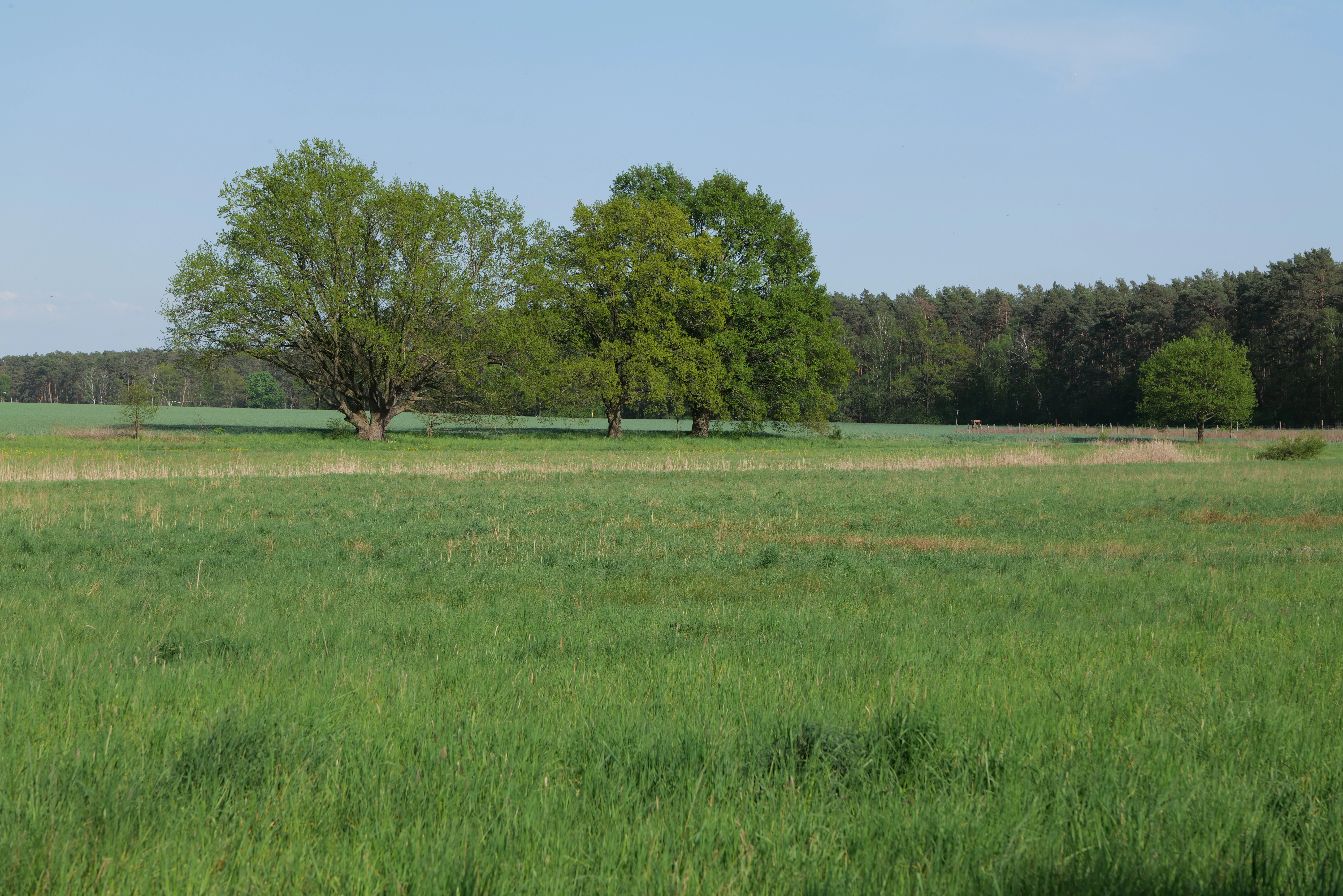
A wide shot of a green grassy meadow with clusters of leafy trees in the middle distance and a darker forest line in the background under a blue sky.
A view of the lowland meadow and tree clusters within Flutgrabenaue Waltersdorf nature reserve.

Flutgrabenaue Waltersdorf history and protected-area timeline

The Flutgrabenaue Waltersdorf was placed under formal nature protection with a regulation dated 12 February 1998, which came into force on 3 April 1998. The protection order is grounded in the European Habitats Directive (92/43/EEC) as well as the Brandenburg nature conservation framework, and administration falls to the Brandenburg State Office for the Environment, specifically its ecology, nature protection, and water department.

The reserve was designated in response to growing settlement and infrastructure pressure on the southern edge of Berlin, including the expansion of suburban communities and the development of the Berlin Brandenburg Airport. Its establishment recognized the area as a representative example of the historic Mark Brandenburg lowland floodplain, deserving protection both for its ecological value and for its cultural landscape character shaped by extensive farming traditions.

Flutgrabenaue Waltersdorf landscape and geographic character

The terrain at Flutgrabenaue Waltersdorf is typical of the southern Brandenburg lowlands: a wide, flat floodplain molded by glacial meltwater and centuries of agricultural drainage. The Flutgraben, a slow sinuous stream, runs through the middle of the reserve, flanked by soft, waterlogged soils. Gentle, almost imperceptible gradients mean that small changes in level determine where reeds, sedge marsh, wet meadow, and forest take hold, producing a finely nuanced wetland mosaic rather than dramatic relief.

Beyond the watercourse itself, the landscape includes open country with pollarded willows, field copses, orchard meadows, and traditional tree-lined avenues that mark old field boundaries and paths. These elements together give the reserve the visual character of a classic, largely unbuilt Mark Brandenburg marshland, an impression its protection aims to preserve against the encroaching infrastructure of greater Berlin.

Flutgrabenaue Waltersdorf ecosystems, habitats, and plant life

Ecologically, Flutgrabenaue Waltersdorf is defined by its floodplain habitats. Alnus glutinosa dominated alder woods and alder-ash forests line the wetter parts of the Flutgraben and its back channels, with sedge marshes (including Carex acuta and slender sedge communities), reed beds, and willow thickets occupying the transitional zones. Extensive wet and moist meadows form the open core of the reserve, with characteristic Glatthafer fresh meadows on slightly drier ground and a scattering of traditional orchards along the edges.

The flowing water itself supports well-developed submerged and emergent aquatic plant communities, and the mosaic of open grassland, scrub, woodland, and water creates a habitat gradient unusually rich for a site so close to a major city. The conservation focus is on maintaining this heterogeneity, including the continuation of extensive forms of land use that prevent the succession of open wetland into closed forest.

Flutgrabenaue Waltersdorf wildlife and species highlights

The reserve is particularly valuable for birds tied to open wet farmland and flowing water habitats. Species highlighted in conservation assessments include the whinchat (Braunkehlchen), white stork (Weißstorch), corncrake (Wachtelkönig), grey partridge (Rebhuhn), northern lapwing (Kiebitz), red-backed shrike (Neuntöter), and meadow pipit (Wiesenpieper). Together they underline the importance of the area for ground-nesting meadow birds and for species reliant on insect-rich, structurally varied farmland edges.

The combination of alder swamp forest, marshland, and flowing water also supports a wider fauna of amphibians, wetland invertebrates, and small mammals typical of Brandenburg floodplains, although these communities are less explicitly documented than the birdlife.

Flutgrabenaue Waltersdorf conservation status and protection priorities

Designated as a European-protected area under the EU Habitats Directive, Flutgrabenaue Waltersdorf is intended to safeguard habitats and species of community importance in the face of intense pressure from the surrounding Berlin metropolitan region. Its core conservation aims are the preservation of wet meadow communities, reed beds, willow shrubs, alluvial forests, alder swamps, and the associated flowing water system, as well as the protection of traditional cultural landscape elements such as field copses, pollarded willows, and tree-lined avenues that give the area its regional identity.

The reserve is classified by IUCN as a Category IV Habitat/Species Management Area, reflecting an active management approach rather than strict non-intervention. Maintaining extensive, traditional land use in the wetlands is recognized as essential to keeping the open character of the meadows and the habitat conditions required by species such as corncrake, whinchat, and white stork, while preventing the encroachment of scrub and forest succession.

Flutgrabenaue Waltersdorf cultural meaning and human context

The reserve represents a surviving fragment of the traditional Mark Brandenburg Niederungslandschaft, or lowland cultural landscape, shaped by centuries of grassland management, haymaking, grazing, and the careful maintenance of avenues and orchards. Pollarded willows, old avenues, and scattered orchards visible in the landscape connect the ecological protection of the area to its rural heritage, making the reserve a conservation project as much about cultural landscape identity as about habitats and species.

Top sights and standout views in Flutgrabenaue Waltersdorf

A near-natural Brandenburg lowland floodplain with a defining flowing watercourse, the Flutgraben, set amid wet meadows, reed beds, and alder swamp forest; one of the few remaining pieces of open, traditionally managed countryside south of Berlin; a refuge for threatened meadow birds such as corncrake, whinchat, white stork, and red-backed shrike; and an example of how EU Habitats Directive protection can be applied to small but ecologically rich wetland sites under intense suburban and infrastructural pressure.

Best time to visit Flutgrabenaue Waltersdorf

Spring and early summer are generally the most rewarding seasons for visiting Flutgrabenaue Waltersdorf, when wet meadows are in bloom and ground-nesting meadow birds such as whinchat and lapwing are active. Late spring through early summer also brings lush vegetation and the strongest contrast between green meadows, reed fringes, and alder woodland. Autumn offers quieter conditions and visible waterfowl and stork activity, while winter can highlight the geometric pattern of pollarded willows and avenues against bare meadows.

Monthly climate preview

Long-term temperature ranges and precipitation patterns recorded across twelve months

Flutgrabenaue Waltersdorf Climate Normals and Average Temperatures by Month

Representative coordinates capture measured monthly temperature swings from sub-zero winter minimums to warm summer maximums alongside consistent daily precipitation averages. Examining the complete twelve-month record provides detailed statistical context on long-term climatic variations across the protected terrain.
Annual mean9 °C
-1 °C20 °C
Jan-1°
Feb
Mar
Apr
May14°
Jun18°
Jul20°
Aug20°
Sep15°
Oct
Nov
Dec
Warmest month
July

20.3 °C

Coolest month
January

-0.9 °C

Wettest month
July

2.4 mm/day

Driest month
April

1.1 mm/day

Park location guide

Geography guide, regional context, and park location map for Flutgrabenaue Waltersdorf

Flutgrabenaue Waltersdorf park geography, regions, and map view in Germany

Understand where Flutgrabenaue Waltersdorf sits in Germany through a broader geographic reading of the surrounding landscape, nearby location context, and its mapped position within the national park landscape.

How Flutgrabenaue Waltersdorf fits into Germany

Germany is a federal republic in Western and Central Europe with a population of over 83 million across sixteen constituent states. It is Europe's largest economy by nominal GDP and a major global exporter and importer. The capital is Berlin, and the country borders Denmark, Poland, Czech Republic, Austria, Switzerland, France, Luxembourg, Belgium, and the Netherlands.

Wider geography shaping Flutgrabenaue Waltersdorf in Germany

Germany is located in Western and Central Europe, spanning 357,022 km². It borders Denmark to the north, Poland and the Czech Republic to the east, Austria and Switzerland to the south, and France, Luxembourg, Belgium, and the Netherlands to the west. The country has coastlines on the Baltic Sea and North Sea to the north, with the Alps located in the southern region.

Map view of Flutgrabenaue Waltersdorf

Use this park location map to pinpoint Flutgrabenaue Waltersdorf in Germany, understand its exact geographic position, and read its mapped placement within the surrounding landscape more clearly.

Pigeon | © OpenStreetMap contributors

Location context for Flutgrabenaue Waltersdorf

Brandenburg

Visual reference collection showcasing lowland floodplain terrain, wet meadows, and rare habitats.

Flutgrabenaue Waltersdorf Landscape and Protected Wetland Scenery Photos

Examine detailed photography of Flutgrabenaue Waltersdorf to understand the unique terrain, waterways, and diverse wetland habitats of this protected Brandenburg nature reserve. Visual archives reveal the characteristic lowland floodplain scenery and traditional marshland character preserved southeast of Berlin.

A wide shot of a green grassy meadow with clusters of leafy trees in the middle distance and a darker forest line in the background under a blue sky.

Park atlas

Compare adjacent wetland habitats and regional lowland landscapes in Brandenburg

Explore Other Protected Areas and Parks Near Flutgrabenaue Waltersdorf

Browsing other protected areas near Flutgrabenaue Waltersdorf reveals the wider ecological patterns of the southern Brandenburg lowlands. Regional park comparison highlights connected floodplain reserves, river valleys, and traditional wetland habitats across the surrounding territory.
A watercolor painting showing a soft, abstract landscape with rolling hills, a central body of water, and a tree-lined shoreline.
Nature reserveBerlin
About 6.1 km away#1 closest

Northeast

Krumme Lake Nature Reserve: Geographic Overview and Protected Wetland Boundaries in Berlin

A preserved mosaic of alder swamp forest and Dahme floodplain habitat

Krumme Lake preserves a dense network of wetland habitats within the pine-dominated forests of Berlin's Treptow-Köpenick borough. This protected nature reserve integrates groundwater-influenced ecosystems and riparian forest remnants, providing a sanctuary for diverse amphibians and invertebrates that have become increasingly rare in surrounding urbanized landscapes.

Area
0.452 km²
Established
2004
IUCN
IV
Relief
Lowland
Nature reserveBrandenburg
About 8.1 km away#2 closest

Southeast

Tiergarten Nature Reserve: Geography and Protected Habitat Mapping in Brandenburg, Germany

Ancient oak woodland, riparian wetlands, and historic forest trails.

Spanning 158 hectares, the Tiergarten nature reserve serves as an ecologically rich sanctuary of oak-hornbeam forests and wet meadows. This area, formerly a royal hunting ground, offers a dense mosaic of riparian zones along the Staabe river, protecting essential habitats within the broader Brandenburg landscape.

Area
1.58 km²
Established
1995
IUCN
IV
Nature reserveBerlin
About 8.6 km away#3 closest

Northeast

Teufelsseemoor Köpenick: Protected Kettle Bog Geography and Urban Wetland Atlas

Glacial landscape and conservation zone in Berlin, Germany

Teufelsseemoor Köpenick is a key nature reserve in Berlin that showcases the transition from post-glacial kettle hole to a thriving peatland and swamp forest. This protected area stands out for its ecological gradient and serves as a model of urban wilderness conservation. The site is defined by the contrast between its still waters and the surrounding moraine ridges of the Müggelberge.

Area
0.065 km²
Established
2016
IUCN
IV
A wide watercolor illustration showing a calm lake with small tree-covered islands, bordered by green forests and distant hills under a pale sky.
Protected areaBrandenburg
About 9.4 km away#4 closest

East

Wernsdorfer See Protected Area: Geographic Mapping and Landscape Context in Brandenburg

Glacial wetland mosaic featuring dunes and reedbeds

Wernsdorfer See is an essential nature reserve in Brandenburg that showcases a rare mix of habitats, from open sandy dunes and grasslands to shallow marshland and reedbeds. Managed as part of the Natura 2000 network, the site serves as a vital refuge for bird species and rare wetland flora. This overview traces the geography and terrain of the Spree valley lowland, offering a structured perspective on its conservation landscape.

Area
1.387 km²
Established
1967
Relief
Lowland
Climate
Temperate
Protected landscapeBerlin
About 10 km away#5 closest

Northwest

Vogelschutzgebiet am Wildmeisterdamm in Rudow: Berlin Urban Protected Woodland Map

Historical bird sanctuary and broadleaf landscape in Neukölln

Spanning roughly 3.75 hectares in the Gropiusstadt district, this site functions as an important refuge for urban birdlife amidst dense residential development. The woodland features a mix of oak, birch, and elm trees, preserved for their ecological continuity since the site first gained official protection in the early twentieth century.

Area
0.038 km²
Established
1934
IUCN
V
Relief
Lowland
Nature reserveBerlin
About 11 km away#6 closest

Northwest

Wasserwerk Johannisthal Nature Reserve: Mapping Berlin's Industrial and Hydrological Landscape

A protected urban groundwater zone in Treptow-Köpenick.

Explore the unique geography of Wasserwerk Johannisthal, a nature reserve in Berlin that balances industrial heritage with modern environmental management. This thirty-five-hectare site offers insights into urban protected areas, showing how historic water infrastructure is now secured for groundwater monitoring and remediation, set against the backdrop of the city's complex transport and green-space network.

Area
0.35 km²
Established
2007
IUCN
IV
Relief
Lowland
A horizontal watercolor painting of a calm river or wetland area with trees, shoreline grasses, and rolling hills in the background, executed in a soft, muted style.
Nature reserveBerlin
About 12 km away#7 closest

Northeast

EU-Vogelschutzgebiet Müggelspree: Protected Nature Reserve and Spree Valley Geography

Bird sanctuary and wetland landscape in southeastern Berlin

As a protected bird sanctuary within the European Natura 2000 network, the EU-Vogelschutzgebiet Müggelspree features an intricate mix of river corridors, fens, and pine forests. This reserve maintains significant ecological connectivity through the Spree lowlands, providing stable breeding and passage environments for numerous avian species. Its unique landscape architecture offers a clear view into the intersection of glacial sand formations and active floodplain ecosystems on the outskirts of Berlin.

Area
8.002 km²
Established
1997
A horizontal watercolor illustration depicting a soft, serene landscape with green trees, pink flowering trees, and gentle hills on a white background.
Nature reserveBrandenburg
About 12 km away#8 closest

Southeast

Skabyer Torfgraben Nature Reserve: Geographic Mapping and Protected Area Overview

Wetland landscape corridors within Brandenburg, Germany

The Skabyer Torfgraben nature reserve provides a focused look at lowland stream ecosystems and rare through-flow peatland remnants. This protected area in the Dahme-Spreewald region serves as a crucial habitat mosaic, blending sandy birch-oak forests with sedge-dominated wet meadows. Examine its natural terrain and hydrological connections to the Dahme river within the context of German protected landscapes.

Area
3.049 km²
Established
1998
IUCN
IV
Relief
Lowland

Common questions about visiting, size, designation, and location context for Flutgrabenaue Waltersdorf

Flutgrabenaue Waltersdorf FAQs for park facts, access, geography, and protected area context

Find quick answers about Flutgrabenaue Waltersdorf, including protected-area facts, park geography, trail and visitor context, and how the park fits into its surrounding country and regional landscape.
MoriAtlas Explorer

Continue Your Protected Areas Search Across the Global Atlas

Deepen your exploration by continuing the structured search for national parks and protected areas worldwide. Utilize the comprehensive filtering capabilities to compare different conservation landscapes and refine your understanding of global park geography. Discover more about the distribution and characteristics of protected natural areas.

Global natural geography