

Mori Atlas logo
Nature reserveForêt classée de Gonsé

Understanding the woodland savanna dynamics and Massili River floodplain in Burkina Faso

Forêt classée de Gonsé Nature Reserve: Regional Geography and Protected Landscape Atlas

Forêt classée de Gonsé serves as a vital nature reserve and living laboratory within the Oubritenga region of Burkina Faso. This site represents the complex Sudano-Sahelian ecological interface, where recovering indigenous tree and shrub savanna meets the remnants of historical afforestation efforts. Through this detailed atlas record, examine the park's terrain, riverine vegetation corridors along the Massili, and the ongoing landscape restoration processes defining this protected area.

Sudanian woodlandtree and shrub savannariverine vegetationfloodplain forestclassified forestafforestation history

Forêt classée de Gonsé

Nature reserve

Park overview

Structured park overview, official facts, and landscape profile for Forêt classée de Gonsé

Forêt classée de Gonsé park facts, protected area profile, and essential visitor context

Review the core facts for Forêt classée de Gonsé, including designation, size, terrain, visitor scale, habitats, and operating context in one park-focused overview.

About Forêt classée de Gonsé

Forêt classée de Gonsé is one of the formally classified forest reserves of Burkina Faso, a category of protected area that has historically played an important role in setting aside woodlands from full agricultural conversion. The reserve lies in Oubritenga Province, in the center of the country, within commuting distance of Ouagadougou, and represents a transition landscape between Sudanian woodland and Sahelian open formations.

Ecologically, the reserve protects a mosaic of dry Sudanian tree and shrub savanna on the uplands, dominated by members of the Combretaceae family, alongside more humid riverine vegetation in the floodplain of the Massili River. The combination of upland savanna and gallery-like strips along the watercourse gives the reserve a layered vegetation structure typical of the northern edge of the Sudanian zone.

The reserve's character is strongly linked to its management history. A former afforestation initiative implemented with support from German technical cooperation divided the forest into compartments, cleared substantial areas, and replanted them largely with non-native species, notably Gmelina arborea and various Eucalyptus species. The project met with resistance from neighboring communities, which had little interest in the exotic trees, and the plantations have since been partially displaced by returning natural vegetation. Although introduced species remain visible in parts of the forest, they have not established as dominant formations.

The legacy of the plantation era is mixed. On deeper, rocky soils, scattered Sclerocarya birrea trees, some planted and some occurring naturally, are a characteristic feature of the vegetation and are valued locally. In other areas where Eucalyptus plantings once stood, the soil has been left vulnerable to water erosion, leaving bare patches that contrast with the surrounding recovering savanna.

Today, Forêt classée de Gonsé also functions as a research and demonstration site. The University of Ouagadougou and the Centre National de Semences Forestières conduct experimental plantings of native Sahelian and Sudanian species, including Ziziphus, assessing which indigenous trees are best suited to restoration in this climatic zone. Guided visits for tourists and specialists are available for a fee, with the forest service office in the village of Gonsé serving as the main point of contact along the main road east of the protected area.

Quick facts and research context for Forêt classée de Gonsé

Forêt classée de Gonsé is a classified woodland reserve in central Burkina Faso, situated in the Oubritenga Province about 25 km east of Ouagadougou. The protected area falls within the North Sudanian vegetation zone and is traversed by the Massili River, whose floodplain supports distinctive riverine vegetation.

The reserve is administratively designated as a forêt classée, a formal class of protected forest under Burkinabè law, and is used for ecological research and supervised tourism. It is associated with experimental planting work by the University of Ouagadougou and the Centre National de Semences Forestières, focused on native Sahelian and Sudanian species.

Protection and recognition

Examine documented terrestrial conservation scope and recognition history.

Forêt classée de Gonsé Protection Status and Designated Area Record

Forêt classée de Gonsé maintains a registered terrestrial protection scope within its designated conservation boundaries. Verified records outline the baseline legal framework and administrative status governing this protected area.

Protection details

Protection scope
Terrestrial
Park context

Deeper park guide and search-rich context for Forêt classée de Gonsé

Forêt classée de Gonsé history, landscape, wildlife, and travel context

Explore Forêt classée de Gonsé through its history, landscape character, ecosystems, wildlife, conservation priorities, cultural context, and seasonal travel timing in a structured park guide built for atlas discovery and search intent.

Why Forêt classée de Gonsé stands out

Gonsé is best known as a case study in Sudano-Sahelian woodland restoration and the long-term legacy of exotic reforestation efforts in Burkina Faso. The reserve illustrates how Gmelina arborea and Eucalyptus plantations, once established against local opposition, have largely failed to persist as self-sustaining stands, while natural Combretaceae-dominated savanna and Mitragyna inermis riverine vegetation are reclaiming much of the area. The forest is also notable for its research role: it serves as a living laboratory for studying Sahelian tree species' potential in the North Sudanian zone, and as a documented example of erosion problems linked to past afforestation practices on fragile soils.
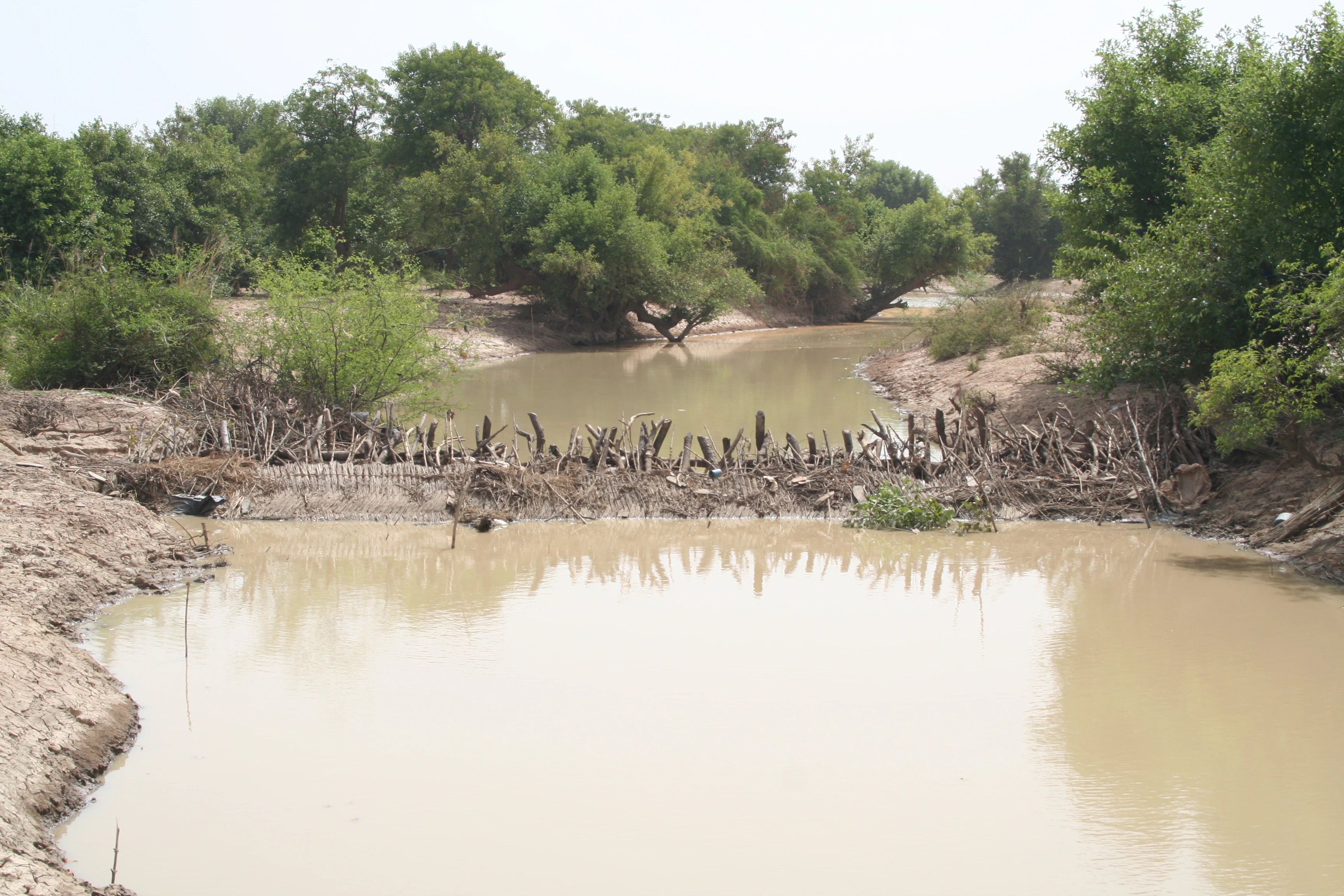
Massili river
The Massili river at the border of the Gonsé classified forest, Burkina Faso

Forêt classée de Gonsé history and protected-area timeline

The modern history of Forêt classée de Gonsé is closely linked to a major state-led afforestation effort of the late twentieth century. The project was carried out with the involvement of the German technical cooperation agency (Deutsche Gesellschaft für Technische Zusammenarbeit), and was aimed at restoring forest cover in parts of the reserve. The intervention was structured around the division of the forest into discrete parcels that were cleared and replanted, largely with fast-growing exotic species.

Two non-native trees dominated the replanting effort: Gmelina arborea and several Eucalyptus species. These were introduced because of their rapid growth and the perceived value of timber and fuelwood production. However, the project was opposed by the surrounding communities, who had little practical interest in the exotic species and preferred native trees that provided useful local products.

Over time, the plantations proved unstable. The exotic species did not spread widely as self-regenerating stands, although individual trees and clumps remain visible within the forest. Between the planted compartments, spontaneous native vegetation re-established itself, gradually returning much of the reserve to a savanna-like character. In some compartments, however, the combination of cleared ground and unsuitable plantation species contributed to severe water-driven soil erosion, leaving degraded, sparsely vegetated patches that contrast with the recovering woodland around them.

More recently, the reserve has become a focus for research-based restoration. The University of Ouagadougou and the Centre National de Semences Forestières use parts of Gonsé to run experimental plantings of native Sahelian and Sudanian species, including various Ziziphus taxa, with the goal of identifying indigenous trees adapted to the local transition zone. These activities represent a shift from earlier exotic-species-led approaches to an emphasis on locally appropriate restoration methods.

Forêt classée de Gonsé landscape and geographic character

Forêt classée de Gonsé lies in the gentle terrain of central Burkina Faso, within the northern edge of the Sudanian bioclimatic zone. The topography consists of relatively flat to undulating landforms typical of the Plateau-Central region, crossed by the seasonal Massili River. Soils vary from finer, erosion-prone substrates in former plantation compartments to deeper, rocky, skeletal soils in other parts of the reserve.

The landscape is shaped by a clear contrast between upland dry savanna and the greener, more densely vegetated strips along the Massili floodplain. These riverine corridors interrupt the otherwise open savanna matrix and provide a distinct visual and ecological transition within the reserve. Where past eucalyptus plantations failed, degraded patches of bare or sparsely vegetated ground stand out against the recovering woodland, marking the imprint of mid-twentieth and late-twentieth century land management decisions on the present-day scenery.

Forêt classée de Gonsé ecosystems, habitats, and plant life

The vegetation of Forêt classée de Gonsé is characteristic of the North Sudanian zone, where Sudanian woodland elements begin to give way to more open, drought-adapted Sahelian formations. The dominant vegetation type is tree and shrub savanna, with Combretaceae species as the main structural and compositional component across the uplands. This provides the reserve with its typical dry-forest appearance, with widely spaced trees forming a semi-open canopy over grass and shrub layers.

Along the Massili River, the vegetation shifts into a riverine community dominated by Mitragyna inermis, a species well adapted to seasonal flooding and saturated soils. These floodplain stands create narrow but biologically distinct corridors that contrast with the surrounding savanna and support different ecological processes, including more sustained moisture availability and shade.

In compartments formerly planted with exotic species, natural regeneration has progressively replaced the original plantations across most of the reserve. The non-native Gmelina arborea and Eucalyptus have remained prominent in some areas as standing trees, but they have not spread to form new dominant stands. On the deeper, rocky soils, Sclerocarya birrea occurs both as scattered planted trees and as naturally occurring individuals, making it one of the more conspicuous native elements of the forest.

Forêt classée de Gonsé conservation status and protection priorities

Forêt classée de Gonsé is significant as a long-term example of the ecological challenges of protecting Sudano-Sahelian woodlands in Burkina Faso. Its legal status as a forêt classée places it within the national system of formally protected forests, providing a basis for regulating land use, restricting clearance, and guiding management interventions.

From a conservation perspective, the reserve carries mixed lessons. The exotic-species afforestation campaign left a legacy of erosion, degraded compartments, and partial transformation of the vegetation, illustrating the risks of large-scale plantation approaches in dry tropical environments. At the same time, the spontaneous return of native Combretaceae-dominated savanna and the persistence of Sclerocarya birrea populations show the resilience of indigenous woodland when disturbance is reduced.

The reserve also serves as a platform for applied conservation research. Experimental plantings of native Sahelian and Sudanian species, including Ziziphus taxa, are being used to evaluate which indigenous trees can be propagated successfully in this transition zone, with implications for restoration efforts well beyond the boundaries of Gonsé itself.

Top sights and standout views in Forêt classée de Gonsé

Forêt classée de Gonsé stands out for the striking contrast between recovering indigenous savanna and the visible legacy of past exotic-species afforestation, making it a textbook case of woodland restoration dynamics in the West African Sudano-Sahelian interface.

Its riverine vegetation along the Massili, dominated by Mitragyna inermis, adds a distinctive ecological dimension, while ongoing experimental work with native Sahelian and Sudanian species gives the reserve a strong identity as a living laboratory for park management and restoration in Burkina Faso.

Best time to visit Forêt classée de Gonsé

The dry season, roughly corresponding to the cooler harmattan period between late October and February, tends to offer the most accessible conditions for visiting central Burkina Faso. During these months, vegetation is less dense, animal signs and tree forms in the savanna are easier to observe, and travel conditions on rural roads east of Ouagadougou are generally more reliable than during the main rains.

Wet-season months bring more luxuriant vegetation and more active bird and insect life, but also heavier rainfall, harder ground conditions, and increased difficulty of travel to and within the reserve. Because the forest is primarily a research and educational site rather than a mass-tourism destination, visitors typically arrange guided excursions through the forest service office in the village of Gonsé east of the protected area.
Monthly climate preview

Track monthly temperature variations and precipitation shifts across representative coordinates

Forêt classée de Gonsé Climate Normals, Long Term Temperature and Precipitation Rhythm

Representative point records from nineteen ninety one to twenty twenty map the long term monthly temperature and precipitation rhythm across Forêt classée de Gonsé. Examining the complete twelve month climate profile reveals detailed seasonal variations in average maximum and minimum values.
Annual mean28 °C
23 °C32 °C
Jan23°
Feb26°
Mar30°
Apr32°
May32°
Jun30°
Jul28°
Aug26°
Sep27°
Oct28°
Nov26°
Dec23°
Warmest month
April

32.3 °C

Coolest month
January

23.2 °C

Wettest month
August

7.6 mm/day

Driest month
December

0 mm/day

Park location guide

Geography guide, regional context, and park location map for Forêt classée de Gonsé

Forêt classée de Gonsé park geography, regions, and map view in Burkina Faso

Understand where Forêt classée de Gonsé sits in Burkina Faso through a broader geographic reading of the surrounding landscape, nearby location context, and its mapped position within the national park landscape.

How Forêt classée de Gonsé fits into Burkina Faso

Burkina Faso is a landlocked West African nation. The Mossi people settled the area in the 11th and 13th centuries, establishing kingdoms such as Ouagadougou, Tenkodogo, and Yatenga. The French colonized the region in 1896 as part of French West Africa, and the country gained independence in 1960 as the Republic of Upper Volta before being renamed Burkina Faso in 1984 by President Thomas Sankara.

Wider geography shaping Forêt classée de Gonsé in Burkina Faso

Burkina Faso is a landlocked country in West Africa, bordered by Mali to the northwest, Niger to the northeast, Benin to the southeast, Togo and Ghana to the south, and Ivory Coast to the southwest. The terrain consists primarily of a peneplain with some laterite plateaus in the southeast. The country has several major rivers including the Mouhoun, Nakambe, and Comoé, though most are seasonal.

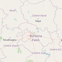
Map view of Forêt classée de Gonsé

Use this park location map to pinpoint Forêt classée de Gonsé in Burkina Faso, understand its exact geographic position, and read its mapped placement within the surrounding landscape more clearly.

Pigeon | © OpenStreetMap contributors

Location context for Forêt classée de Gonsé

Oubritenga

Visualizing habitats, savanna terrain, and protected woodland character in Burkina Faso

Forêt classée de Gonsé Photos and Landscape Scenery

Photographic documentation reveals the distinct topography, recovering Sudanian savanna, and riverine vegetation corridors defining Forêt classée de Gonsé. Visual records illustrate the ecological contrast between upland dry woodland and the seasonal Massili floodplain.

Massili river

Park atlas

Compare regional woodland reserves and connected conservation areas across the Plateau-Central zone

Parks Near For** classée de Gonsé and Surrounding Protected Landscapes

Browsing other protected areas near Forê t classée de Gonsé reveals the wider ecological context of the Sudanian savanna transition. Expanding the geographic comparison helps trace regional woodland management patterns and similar conservation landscapes throughout Burkina Faso.
Protected areaBam Province
About 103 km away#1 closest

North

Lac Bam Protected Area: Regional Landscape Map and Geography of Bam Province

Ecological transition zone and natural freshwater reservoir

Lac Bam serves as a critical freshwater site and natural reservoir within the Sahelian-Sudanian transition zone of Burkina Faso. This protected area supports a mosaic of wooded savanna, wetland margins, and open water, defining the hydrology of the surrounding Bam Province. Analyze the landscape dynamics and broad catchment characteristics of this significant inland water system through our integrated geographic dataset.

Area
30 km²
Relief
Lowland
Scope
Terrestrial
Water
Water-dominated
Watercolor depiction of a river flowing through a landscape with green trees and distant mountains under a light sky
National parkBurkina Faso
About 106 km away#2 closest

South

Kaboré Tambi National Park: Burkina Faso's Largest National Park and Protected Landscape

Explore the mapped savanna and birdwatching geography of this vital West African area.

Kaboré Tambi National Park represents a critical protected area in Burkina Faso, spanning a considerable expanse of Sudan-Guinea savanna. The park's geography is defined by the Nazinon River and a mosaic of woodland and grassland ecosystems, making it a significant site for understanding regional protected lands and landscape ecology. It offers a valuable point of reference for atlas-based exploration of West African natural areas.

Area
1,555 km²
Established
1976
IUCN
II
Relief
Lowland
Wildlife reserveBurkina Faso
About 116 km away#3 closest

Southeast

Lac de Bagré Wildlife Reserve: Mapping the Inland Reservoir of Central Burkina Faso

A critical wetland site within the Nakambé River valley.

Lac de Bagré acts as a major freshwater reservoir, stretching through the Boulgou and Zoundwéogo provinces of Burkina Faso. This artificial lake, created by the Bagré Dam, supports a unique ecological profile as a Ramsar-recognized wetland, offering a deep look into the intersection of hydrological infrastructure and protected Sahelian landscapes.

Area
367.93 km²
Established
1992
Water
Water-dominated
National parkBurkina Faso
About 199 km away#4 closest

Southwest

Deux Balés National Park: Burkina Faso's Elephant Sanctuary and Savanna Protected Landscape

Explore mapped terrain and key geographic features of this protected area.

Deux Balés National Park serves as a vital protected area within Burkina Faso, acclaimed for harboring the largest elephant population in West Africa. This national park's protected landscape is defined by undulating granitic plains, lateritic plateaux, and distinct gallery forests lining the Black Volta River. The presence of ancient African baobab trees adds a unique visual character to the savanna ecosystem. Investigating this park reveals its significance for regional conservation, its mapped geographic boundaries, and its role within the broader context of protected lands in West Africa.

Area
810 km²
Established
1937
IUCN
II
Relief
Lowland
Wildlife reserveUpper West Region
About 231 km away#5 closest

Southwest

Gbele Resource Centre Wildlife Reserve: A Regional Atlas of Protected Savanna Landscapes

Mapped geography and protected woodland in Ghana

Gbele Resource Centre represents one of the most substantial protected savanna landscapes in northwestern Ghana, spanning over 500 square kilometres of Sudano-Sahelian woodland. The terrain is defined by the seasonal Kulpawn River and a distinct composition of African baobab and sycamore fig trees, which together anchor an important ecological corridor. This reserve provides a vital opportunity to map and understand the conservation geography and avian diversity that distinguish the Upper West Region from other parts of the country.

Area
565 km²
Relief
Lowland
Scope
Terrestrial
Water
Minor water
National parkSavanes Region
About 242 km away#6 closest

Southeast

Fosse aux Lions National Park: National Park Exploration in Togo's Savanes Region

Mapped protected area geography and landscape context.

Fosse aux Lions National Park represents a distinct protected landscape within the Savanes Region of Togo. This entry focuses on its identity as a national park, providing structured information on its geographic placement and mapped boundaries. It serves as a core element for understanding the distribution of protected areas and the specific natural terrain within this region of Togo, aiding in comprehensive atlas-style exploration.

Area
16.5 km²
Established
1954
IUCN
II
Relief
Lowland
Protected areaKompienga Province
About 253 km away#7 closest

Southeast

Lac de la Kompienga: Geography and Mapped Protected Landscapes in Kompienga Province

A landmark hydroelectric reservoir and wetland habitat

Lac de la Kompienga constitutes a primary water resource and ecological site within the dry savanna of Burkina Faso. This artificial reservoir creates a vital wetland mosaic, supporting diverse aquatic birdlife and fisheries while functioning as a critical component of the regional Volta Basin hydrology. The site captures the transition between engineered water management and the natural dry woodland ecosystems characteristic of the Est Region.

Area
175.45 km²
Established
1988
Relief
Lowland
Scope
Terrestrial
National parkSavannah Region
About 254 km away#8 closest

South

Mole National Park: A Premier Protected Landscape in Ghana's Savannah Region

Explore mapped boundaries and Guinea savannah ecosystems.

Mole National Park represents a significant protected landscape within Ghana's Savannah Region, serving as the country's largest national park and a crucial conservation area for West African wildlife. The park's geography is defined by extensive Guinea savannah, characterized by grasslands with scattered woodlands and a prominent escarpment along its southern edge. Its vast expanse offers a unique opportunity to study mapped park boundaries and understand the ecosystem's role in regional conservation efforts. Discover the unique landscape context and protected area identity of this major West African wildlife refuge.

Area
4,840 km²
Established
1958
IUCN
II
Visitors
17.8K annual

Common questions about visiting, size, designation, and location context for Forêt classée de Gonsé

Forêt classée de Gonsé FAQs for park facts, access, geography, and protected area context

Find quick answers about Forêt classée de Gonsé, including protected-area facts, park geography, trail and visitor context, and how the park fits into its surrounding country and regional landscape.
MoriAtlas Explorer

Continue Your Protected Areas Search Across the Global Atlas

Deepen your exploration by continuing the structured search for national parks and protected areas worldwide. Utilize the comprehensive filtering capabilities to compare different conservation landscapes and refine your understanding of global park geography. Discover more about the distribution and characteristics of protected natural areas.

Global natural geography

