
Mori Atlas logo
Protected landscapeLandschaftsschutzgebiet Freiflächen um Erlinghausen / Auf der Sandkuhle

Examining the cultural landscape and traditional orchard meadows of the Hochsauerlandkreis region

Landschaftsschutzgebiet Freiflächen um Erlinghausen / Auf der Sandkuhle Protected Landscape Geography

The Landschaftsschutzgebiet Freiflächen um Erlinghausen / Auf der Sandkuhle represents a significant protected area within the Hochsauerlandkreis district of Germany. This landscape preserves a mosaic of open farmland, historic orchard rows, and traditional meadows that maintain the visual identity of the Sauerland countryside. It serves as a vital ecological corridor, linking neighboring protected zones while highlighting geological features like limestone quarries and ancient sunken lanes.

protected landscapeagricultural landscapeorchard meadowsorchard rowsopen farmlandcountryside reserve
A flat vector-style illustration featuring tall mountain cliffs, a waterfall, a winding river, and pine trees in the foreground.

Landschaftsschutzgebiet Freiflächen um Erlinghausen / Auf der Sandkuhle

Protected landscape

Park overview

Structured park overview, official facts, and landscape profile for Erlinghausen Openlands and Sandkuhle Protected Landscape

Erlinghausen Openlands and Sandkuhle Protected Landscape park facts, protected area profile, and essential visitor context

Review the core facts for Erlinghausen Openlands and Sandkuhle Protected Landscape, including designation, size, terrain, visitor scale, habitats, and operating context in one park-focused overview.

About Erlinghausen Openlands and Sandkuhle Protected Landscape

Erlinghausen Openlands and Sandkuhle Protected Landscape is a countryside protection zone in the eastern Sauerland region, situated in the Hochsauerlandkreis district of North Rhine-Westphalia. Encompassing 548.7 hectares, it forms a ring of open farmland and cultural landscape features around the village of Erlinghausen, which lies within the broader municipal area of Marsberg. The reserve was formally established in 2008, when the Hochsauerlandkreis district council adopted the Marsberg landscape plan and designated the area as a protected landscape, or Landschaftsschutzgebiet.

The reserve's identity is rooted in the rural character of the Sauerland. Its agricultural open lands are largely used for crop cultivation, interspersed with rows of fruit trees and traditional orchard meadows that have been individually designated as protected landscape components. These orchard rows are a defining visual and ecological element, providing habitat structure and continuity with the region's older farming traditions. Their retention is central to the reserve's purpose, reflecting both ecological function and cultural heritage.

Within the protected area, several distinct features stand out. In the northwest, near Jittenberg, a small abandoned limestone quarry has gradually been reclaimed by shrubs and woody vegetation. At the northeast edge, a remnant of a historic sunken lane has been formally recognized as a cultural monument. Toward the southern part of Erlinghausen, a valley depression extends toward the Hummelgrund, creating a natural transition into the adjacent Platte Protected Landscape and the Hummelgrund Nature Reserve. These neighboring protected areas extend the ecological and landscape network well beyond the boundaries of the reserve itself.

The area's Type B classification under the regional landscape plan framework situates it among reserves dedicated to preserving edge-of-village locations, open land, and the traditional cultural landscape. Its purpose extends beyond ecological protection: it also recognizes the area's special significance for local recreation. Residents and visitors use the surrounding fields, paths, and orchards for walks and quiet enjoyment of the countryside, making the reserve an everyday part of local life as well as a conservation asset.

At its eastern edge, the reserve reaches both the city boundary and the state border, an arrangement that highlights its role in cross-jurisdictional landscape continuity. To the east, it connects directly with the Wulsenberg Nature Reserve and the Hasental / Kregenberg Nature Reserve, two areas of higher conservation status. This connectivity allows the open farmland and orchard habitats of the Erlinghausen reserve to function as part of a larger ecological system that supports biodiversity across the regional landscape.

Quick facts and research context for Erlinghausen Openlands and Sandkuhle Protected Landscape

The Erlinghausen Openlands and Sandkuhle Protected Landscape covers 548.7 hectares around the village of Erlinghausen in Marsberg, within the Hochsauerlandkreis district of North Rhine-Westphalia. It was designated in 2008 through the Marsberg landscape plan, adopted by the district council of Hochsauerlandkreis.

The area is classified as a Type B landscape plan area, emphasizing the protection of edge-of-village open land and traditional cultural landscapes. It borders the Wulsenberg Nature Reserve and the Hasental / Kregenberg Nature Reserve to the east, and connects ecologically with the Platte Protected Landscape and the Hummelgrund Nature Reserve to the south.

Protection and recognition

Documented terrestrial protection scope, designation records, and international recognition data

Landschaftsschutzgebiet Freiflächen um Erlinghausen / Auf der Sandkuhle Protection Status

Terrestrial protection status records provide foundational baseline data for Landschaftsschutzgebiet Freiflächen um Erlinghausen / Auf der Sandkuhle. Structured conservation facts document administrative parameters and international recognition frameworks without presumption of management outcomes.

Protection details

Protection scope
Terrestrial
Park context

Deeper park guide and search-rich context for Erlinghausen Openlands and Sandkuhle Protected Landscape

Erlinghausen Openlands and Sandkuhle Protected Landscape history, landscape, wildlife, and travel context

Explore Erlinghausen Openlands and Sandkuhle Protected Landscape through its history, landscape character, ecosystems, wildlife, conservation priorities, cultural context, and seasonal travel timing in a structured park guide built for atlas discovery and search intent.

Why Erlinghausen Openlands and Sandkuhle Protected Landscape stands out

The reserve is best known for its preservation of traditionally managed farmland, orchard rows, and orchard meadows surrounding the village edges of Erlinghausen. These open landscapes form a transitional zone between the built village and the surrounding Sauerland countryside, retaining the character of an older agricultural landscape. A particular point of interest is a small abandoned limestone quarry overgrown with shrubs near Jittenberg in the northwest, along with a heritage-listed sunken lane remnant at the northeast edge of the reserve. Together, these elements reflect the layered geological and cultural history of the area.
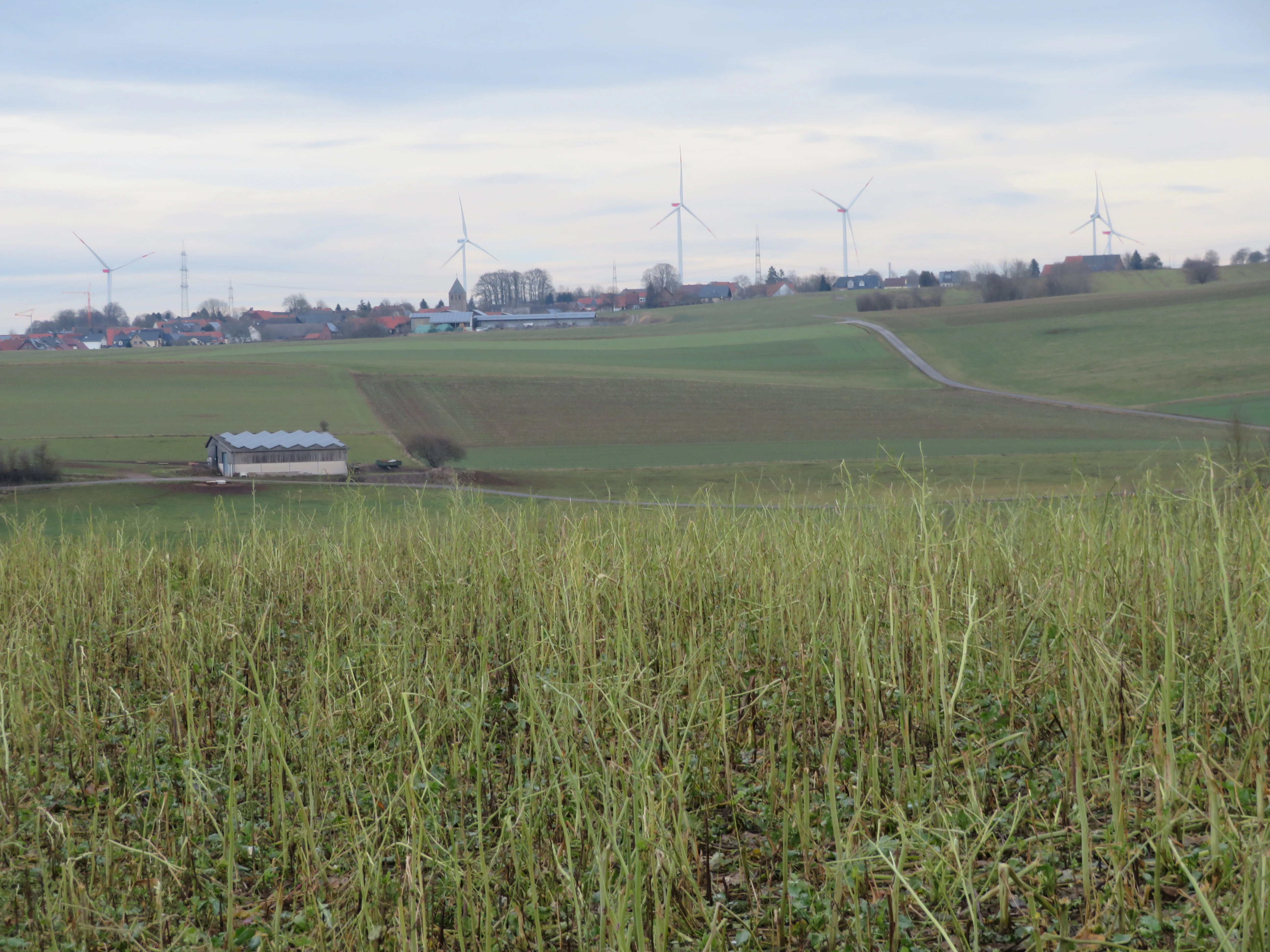
Wide shot of a rural landscape with a field of harvested crops in the foreground, rolling green hills, a small building, and a village with wind turbines on the horizon under an overcast sky.
Agricultural landscape near Erlinghausen showing rolling fields and wind turbines in the distance.

Erlinghausen Openlands and Sandkuhle Protected Landscape history and protected-area timeline

The protected landscape was formally established in 2008, when the district council of the Hochsauerlandkreis adopted the Marsberg landscape plan. This plan provided the legal framework for designating several protected areas within the Marsberg municipal territory, including the openlands around Erlinghausen and the area known as Auf der Sandkuhle.

The reserve's designation reflects a broader regional effort to maintain and actively manage the traditional cultural landscape of the eastern Sauerland. By classifying the area as a Type B landscape plan area, the regional authorities emphasized the importance of protecting both open land and edge-of-village landscapes, recognizing them as integral to the area's identity and ecological function. The reserve's adoption was accompanied by specific land-use regulations aimed at preserving the area's open character and preventing forest encroachment.

Erlinghausen Openlands and Sandkuhle Protected Landscape landscape and geographic character

The landscape of the Erlinghausen reserve is shaped by gently rolling agricultural land typical of the eastern Sauerland foothills. Flat to moderately sloping fields surround the village of Erlinghausen, with the terrain marked by small-scale topographic features rather than dramatic relief. Much of the area is open farmland, dominated by cultivated fields that maintain the broad visual sweep of the countryside.

One of the most distinctive landscape elements is a series of orchard rows and orchard meadows, many of which are individually protected as landscape components. These tree-lined features break up the otherwise open agricultural matrix and lend the area its traditional cultural character. In the northwest, near Jittenberg, a small abandoned limestone quarry introduces a contrasting feature, its rocky edges now softened by regenerating shrubs and trees.

Toward the northeast, a remnant of an old sunken lane preserves a historic route through the landscape, recognized as a cultural monument for its importance to local heritage. On the southwestern edge near Höling, the terrain includes a thymian-rich area used as a model aircraft flying field, illustrating how varied land use can coexist with protection goals. South of Erlinghausen, a shallow valley extends toward the Hummelgrund, linking the reserve visually and ecologically to adjacent protected landscapes to the south.

Erlinghausen Openlands and Sandkuhle Protected Landscape ecosystems, habitats, and plant life

Ecologically, the Erlinghausen reserve functions as a transitional landscape between the built environment of the village and the broader natural systems of the Sauerland. Its open farmland, combined with the structured orchard rows and meadow strips, creates a mosaic of habitats that supports a range of species typical of mixed agricultural countryside in central Germany.

The orchard rows are particularly important for biodiversity, offering nesting sites, food resources, and shelter for insects, birds, and small mammals. As linear landscape elements, they also serve as ecological corridors, connecting different parts of the reserve and linking to the habitats of neighboring protected areas. The small abandoned limestone quarry, with its regenerating shrub cover, adds further habitat diversity by providing rocky microhabitats and structural variation.

The reserve's eastern connection to the Wulsenberg and Hasental / Kregenberg nature reserves extends its ecological reach. Southward, the valley toward the Hummelgrund connects with the Platte Protected Landscape and the Hummelgrund Nature Reserve, allowing species and ecological processes to flow across a broader landscape network. This positioning gives the reserve a disproportionate importance relative to its size, acting as a connective link between multiple higher-status protected areas.

Erlinghausen Openlands and Sandkuhle Protected Landscape wildlife and species highlights

Although detailed species inventories are not central to the reserve's published description, the habitat mosaic of cultivated fields, orchard rows, and shrub-covered quarry edges supports a community of wildlife typical of traditional mixed agricultural landscapes. The orchard meadows, in particular, are recognized for their ecological value, providing habitats for insects, breeding birds, and small mammals.

The reserve's role in connecting with adjacent nature reserves, including Wulsenberg, Hasental / Kregenberg, and Hummelgrund, further enhances its importance for regional wildlife movements. These ecological linkages support broader biodiversity patterns across the Hochsauerlandkreis, allowing species to move between protected habitats through the network of working farmland and orchard features that the Erlinghausen reserve helps to maintain.

Erlinghausen Openlands and Sandkuhle Protected Landscape conservation status and protection priorities

The reserve's conservation purpose centers on maintaining the diversity and character of the landscape in the immediate vicinity of the village and its historically important agricultural zones. By securing open farmland and traditional orchard features, the designation ensures that long-standing land use patterns continue to shape the local environment, while preventing the gradual loss of open land through forest succession or unregulated development.

Protection is also explicitly linked to the area's value for recreation. The reserve acts as a nearby natural space for Erlinghausen and the broader Marsberg area, offering accessible countryside for residents and visitors. Legally, the protected landscape establishes restrictions on new construction and limits activities such as afforestation and the establishment of Christmas tree or nursery plantations, thereby ensuring that land use remains aligned with the area's conservation and open-land objectives.

By connecting directly with several nature reserves and additional protected landscapes, the Erlinghausen reserve strengthens the broader conservation network of the Hochsauerlandkreis. Its location at the eastern edge of Marsberg, reaching both the city and state boundary, gives it regional significance as a transitional zone between higher-protection habitats and the surrounding cultural landscape.

Erlinghausen Openlands and Sandkuhle Protected Landscape cultural meaning and human context

The reserve reflects the long-standing agricultural traditions of the Sauerland region, where small villages such as Erlinghausen have been shaped by generations of mixed farming and orchard cultivation. The protected orchard rows and orchard meadows are not merely ecological features but represent a continuation of regional land use practices that have defined the local countryside for centuries.

The cultural dimension is reinforced by the presence of a heritage-listed sunken lane remnant at the northeast edge of the reserve. This preserved historical route connects the protected area directly to the broader cultural heritage of the region, illustrating how everyday agricultural landscapes can also be carriers of local history and identity. The reserve's protection of these features acknowledges the interplay between human land use and the visual and ecological character of the Sauerland.

Top sights and standout views in Erlinghausen Openlands and Sandkuhle Protected Landscape

Among its most distinctive features, the reserve preserves extensive orchard rows and traditional orchard meadows that have been individually protected as landscape components. These linear and patch habitats give the area much of its unique identity and ecological value, distinguishing it from purely agricultural or purely natural reserves nearby.

The small overgrown limestone quarry near Jittenberg and the heritage-listed sunken lane remnant at the northeast edge provide additional points of interest, combining geological and cultural history within a single compact area. The reserve's strategic position, adjoining the Wulsenberg and Hasental / Kregenberg nature reserves and linking southward to the Hummelgrund area, makes it an important connective element in the Hochsauerlandkreis conservation network.

Best time to visit Erlinghausen Openlands and Sandkuhle Protected Landscape

As a working agricultural and orchard landscape, the reserve's character shifts with the seasons in ways typical of mixed countryside in the Sauerland. Late spring and early summer bring active growth to the orchard meadows and cultivated fields, when the surrounding wooded edges contrast most strongly with the open farmland. Summer offers the fullest expression of agricultural activity and the warmest conditions for walking through the open fields along village-edge paths.

Autumn is particularly evocative, when orchard harvests and the changing colors of the surrounding landscape emphasize the cultural and agricultural character of the reserve. Even in winter, the open farmland retains its distinctive atmosphere, with the bare orchard trees and quiet field edges offering clear views across the gently rolling terrain. Visitors seeking quiet recreation will find the area especially appealing in the softer light of spring and autumn, when the countryside around Erlinghausen feels most connected to its long-standing farming traditions.

Monthly climate preview

Long-term representative monthly averages for temperature and precipitation distribution

Climate Normals and Annual Temperature Rhythm for Landschaftsschutzgebiet Freiflächen um Erlinghausen / Auf der Sandkuhle

Representative coordinates record winter sub-zero minimums alongside mid-summer maximums exceeding thirty degrees celsius across the annual cycle. Detailed monthly breakdowns provide deeper insight into long-term temperature ranges and precipitation patterns.
Annual mean9 °C
0 °C18 °C
Jan
Feb
Mar
Apr
May12°
Jun15°
Jul18°
Aug18°
Sep14°
Oct
Nov
Dec
Warmest month
July

18 °C

Coolest month
January

-0.2 °C

Wettest month
July

2.6 mm/day

Driest month
April

1.7 mm/day

Park location guide

Geography guide, regional context, and park location map for Erlinghausen Openlands and Sandkuhle Protected Landscape

Erlinghausen Openlands and Sandkuhle Protected Landscape park geography, regions, and map view in Germany

Understand where Erlinghausen Openlands and Sandkuhle Protected Landscape sits in Germany through a broader geographic reading of the surrounding landscape, nearby location context, and its mapped position within the national park landscape.

How Erlinghausen Openlands and Sandkuhle Protected Landscape fits into Germany

Germany is a federal republic in Western and Central Europe with a population of over 83 million across sixteen constituent states. It is Europe's largest economy by nominal GDP and a major global exporter and importer. The capital is Berlin, and the country borders Denmark, Poland, Czech Republic, Austria, Switzerland, France, Luxembourg, Belgium, and the Netherlands.

Wider geography shaping Erlinghausen Openlands and Sandkuhle Protected Landscape in Germany

Germany is located in Western and Central Europe, spanning 357,022 km². It borders Denmark to the north, Poland and the Czech Republic to the east, Austria and Switzerland to the south, and France, Luxembourg, Belgium, and the Netherlands to the west. The country has coastlines on the Baltic Sea and North Sea to the north, with the Alps located in the southern region.

Map view of Erlinghausen Openlands and Sandkuhle Protected Landscape

Use this park location map to pinpoint Erlinghausen Openlands and Sandkuhle Protected Landscape in Germany, understand its exact geographic position, and read its mapped placement within the surrounding landscape more clearly.

Pigeon | © OpenStreetMap contributors

Location context for Erlinghausen Openlands and Sandkuhle Protected Landscape

Hochsauerlandkreis

Photographic documentation of traditional agricultural fields, orchard rows, and countryside terrain

Visual Exploration and Protected Landscape Photos of Landschaftsschutzgebiet Freiflächen um Erlinghausen / Auf der Sandkuhle

Visual records reveal the rolling agricultural terrain, traditional orchard meadows, and distinct habitat mosaics defining Landschaftsschutzgebiet Freiflächen um Erlinghausen / Auf der Sandkuhle. Photographic documentation provides critical visual context for understanding regional topography, historical land use, and protected countryside character.

Wide shot of a rural landscape with a field of harvested crops in the foreground, rolling green hills, a small building, and a village with wind turbines on the horizon under an overcast sky.

Park atlas

Compare nearby protected areas and connected regional countryside landscapes

Other Parks Near Landschaftsschutzgebiet Freiflächen um Erlinghausen / Auf der Sandkuhle

Browse protected areas and agricultural reserves situated near Landschaftsschutzgebiet Freiflächen um Erlinghausen / Auf der Sandkuhle. Comparing these adjacent conservation zones reveals the broader ecological network spanning the eastern Sauerland foothills.
Watercolor painting of a wide, soft-toned landscape showing gentle rolling hills, open fields, and a small meandering stream, executed in a minimalist, light-filled style.
Protected landscapeHochsauerlandkreis
About 5.2 km away#1 closest

Southwest

Landschaftsschutzgebiet Freiflächen um Giershagen: Protected Landscape and Regional Map

Agricultural cultural heritage and biodiversity in Hochsauerlandkreis

This protected area in North Rhine-Westphalia preserves 785 hectares of traditional Sauerland countryside. It features extensively managed farmland, rare arable plant habitats, and historically significant landscape structures that support regional biodiversity and long-term ecological stewardship.

Area
7.849 km²
Established
2008
Relief
Upland
Scope
Terrestrial
A soft watercolor painting showing a panoramic view of rolling hills and undulating green and pink landscape features against a pale sky.
Nature reserveWaldeck-Frankenberg
About 5.6 km away#2 closest

North

Naturschutzgebiet Büchenberg und Platzberg bei Hesperinghausen: Geography and Protected Landscapes

A study of limestone slopes and calcareous grassland habitats

This protected area in Waldeck-Frankenberg serves as a key site for calcareous dry grasslands and rare orchid species. The terrain features a striking mosaic of steep Zechstein limestone slopes, rock outcrops, and moisture-rich meadow patches. Analyzing the area reveals how small, traditionally managed reserves can maintain high biodiversity and provide essential connectivity within the Diemeltal regional landscape.

Area
0.418 km²
Established
1993
Relief
Upland
Climate
Temperate
A soft watercolor illustration showing a gentle, rolling landscape with green meadows, trees, and distant hills under a pale sky.
Nature reserveHochsauerlandkreis
About 8.5 km away#3 closest

Southwest

Naturschutzgebiet Östlicher Arnstein: Protected Nature Reserve and Geographic Map

Grassland mosaic and historic terrain in Hochsauerlandkreis

Naturschutzgebiet Östlicher Arnstein comprises 8.5 hectares of species-rich meadows and hedgerow complexes nestled in the Waldecker Gefilde. This reserve offers a significant look at regional grassland conservation, providing habitat diversity through its base-rich soils and disused quarry sites. It acts as a vital transition point between the forested Sauerland slopes and the surrounding open agricultural landscape.

Area
0.085 km²
Established
2001
Relief
Lowland
Climate
Temperate
A horizontal watercolor painting of a calm lake surrounded by a pine forest and rolling hills under a soft light.
Protected landscapeKreis Paderborn
About 9 km away#4 closest

Northwest

Landschaftsschutzgebiet FFH-Gebiet Fürstenberger Wald: Protected Area and Forest Geography

A woodland conservation landscape in the Kreis Paderborn foothills

This protected area features a cohesive block of old-growth beech forest, enriched by significant deadwood habitats and a dense internal network of brooks. Located within the Kreis Paderborn administrative district, the landscape serves as a key ecological connector in the eastern Sauerland, balancing moist valley meadows with upland forest ridges and ongoing deciduous forest restoration efforts.

Area
14.925 km²
Established
2007
Relief
Upland
Climate
Temperate
A watercolor landscape illustration showing soft, rolling green hills, coniferous trees, and a hazy background.
Nature reserveHochsauerlandkreis
About 9.6 km away#5 closest

Southwest

Naturschutzgebiet Padberg: A Protected Landscape in the Hochsauerlandkreis Region

Diabas geology and forest habitat mapping

Naturschutzgebiet Padberg protects a compact but ecologically rich landscape of beech forests and craggy rock cliffs. Its position above the Diemel valley highlights the relationship between volcanic Diabas topography and woodland development within the Hochsauerlandkreis district.

Area
0.467 km²
Established
2001
Relief
Upland
Climate
Temperate
Nature reserveHessen
About 10 km away#6 closest

Southwest

Naturschutzgebiet Am Mühlenberg bei Adorf: Protected Forest and Volcanic Terrain

Geographic overview of a key Hessen nature reserve

Spanning 33 hectares in northern Hessen, Naturschutzgebiet Am Mühlenberg bei Adorf is defined by its Devonian volcanic bedrock and varied microclimates. The reserve provides a detailed look at how aspect and slope create contrasting forest communities, from dry oak stands to cool-air ravine woodland, offering a concentrated study in protected-area botanical richness.

Area
0.335 km²
Established
1992
IUCN
IV
Relief
Upland
A horizontal watercolor illustration of a soft, hazy valley with rolling green hills, distant treelines, and wildflowers in the foreground.
Nature reserveNorth Rhine-Westphalia
About 10 km away#7 closest

West

Naturschutzgebiet Aabachtal Nature Reserve and Sauerland Protected Stream Valley Geography

A preserved fluvial landscape in North Rhine-Westphalia

Naturschutzgebiet Aabachtal is a protected nature reserve in the northern Sauerland of North Rhine-Westphalia. Centered on the Aabach stream, it protects a classic Mittelgebirge valley landscape defined by meandering watercourses, lush floodplain meadows, and deciduous forest slopes, serving as a critical habitat for specialized moisture-loving flora and diverse riparian fauna.

Area
0.716 km²
Established
2001
Relief
Upland
Scope
Terrestrial
A soft watercolor illustration of a landscape featuring layered green hills, a distant forest silhouette, and pale sky, rendered in a light, minimalist style.
Nature reserveHochsauerlandkreis
About 11 km away#8 closest

Southwest

Naturschutzgebiet Oberes Diemeltal: Protected Floodplain and River Geography in Hochsauerlandkreis

Mapped riparian landscapes and riverine conservation corridors

Naturschutzgebiet Oberes Diemeltal preserves an undeveloped section of the upper Diemel river valley. The landscape is defined by its branching river network, wet meadows, and rare floodplain vegetation, offering a clear window into the riverine geography of the eastern Sauerland region in Germany.

Area
1.87 km²
Established
2001
Scope
Terrestrial
Water
Major water bodies

Common questions about visiting, size, designation, and location context for Erlinghausen Openlands and Sandkuhle Protected Landscape

Erlinghausen Openlands and Sandkuhle Protected Landscape FAQs for park facts, access, geography, and protected area context

Find quick answers about Erlinghausen Openlands and Sandkuhle Protected Landscape, including protected-area facts, park geography, trail and visitor context, and how the park fits into its surrounding country and regional landscape.
MoriAtlas Explorer

Continue Your Protected Areas Search Across the Global Atlas

Deepen your exploration by continuing the structured search for national parks and protected areas worldwide. Utilize the comprehensive filtering capabilities to compare different conservation landscapes and refine your understanding of global park geography. Discover more about the distribution and characteristics of protected natural areas.

Global natural geography