
Beaches
Park geography
Detailed geographic data for the coastal landscape within the Tasmania regional context
Freycinet National Park Geography, Mapped Boundaries and Physical Terrain Profile
Freycinet National Park occupies a distinct coastal landscape in Tasmania with a recorded perimeter of over 270 kilometers and a total area of 169 square kilometers. This geographic profile details the park's physical terrain, including mountain peaks like Mount Freycinet and Mount Amos, alongside coastal cliffs, beaches, and temperate forest habitats contained within its administrative boundaries.
Related tags
coastal national parkgranite mountainsTasmanian wildernessbirdwatchingwhale watching
Tasmania's oldest national park protecting dramatic pink granite peaks and pristine coastal wilderness
Freycinet National Park
Freycinet National Park is a coastal protected area on the east coast of Tasmania, Australia, occupying the majority of the Freycinet Peninsula and extending to include Schouten Island. Established in 1916, it holds the distinction of being Tasmania's oldest national park alongside Mount Field National Park. The park spans approximately 169 square kilometres of rugged Tasmanian coastline, featuring the world-renowned Wineglass Bay and the distinctive line of jagged granite peaks known as The Hazards. The landscape is defined by Devonian granite formations, where pink orthoclase feldspar gives the mountains and coastal cliffs their characteristic warm coloration. The park supports significant biodiversity, including forty-nine species endemic to Tasmania, and contains important habitats ranging from dry sclerophyll forests to coastal heathlands and marine environments. Freycinet sits approximately 125 kilometres northeast of Hobart, with the nearby settlement of Coles Bay providing gateway access to this iconic protected landscape.
- Location
- Australia
- Park type
- National park
- Established
- 1916
- Area
- 169 km²
Location overview
A coastal protected area within Tasmania, Australia
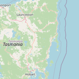
Geographic Setting of Freycinet National Park in Tasmania
Freycinet National Park is located within the state of Tasmania in Australia. As a coastal protected area, the reserve lies entirely inside a single territory rather than crossing international boundaries.
- Countries
- Australia
- Regions
- Tasmania
- Primary location
- Tasmania
- Geographic setting
- Coastal
Boundary and coordinates
Spatial extent, coordinate limits, and the 169 square kilometer total area
Mapping the Boundaries and Protected Area of Freycinet National Park
Interactive boundary maps trace the spatial footprint and geographic shape of the protected coastal reserve. Geographic data tables outline calculated area measurements, center coordinates, and latitudinal spans.
- Boundary area
- 168.6 km²
- Boundary perimeter
- 272.1 km
- Northernmost point
- 41.8941° S
- Southernmost point
- 42.3643° S
- Easternmost point
- 148.3593° E
- Westernmost point
- 148.2215° E
- Geographic centre
- 42.143° S, 148.2929° E
- North–south span
- 52.2 km
- East–west span
- 11.4 km
Terrain and natural features
Mapped coastal landforms, peaks, and offshore island records
Freycinet National Park Terrain and Named Natural Features
Mixed relief classifications span the protected coastal landscape alongside recorded peaks, headlands, and island formations. Linked feature cards supply official names, types, and spatial relationships across the territory.
Selected named natural features
Capes
Weatherhead Point
Islands
Half Lemon Rock
Capes
Cape Lodi
Streams
Ranger Creek
Islands
Taillefer Rocks
Environmental setting
Temperate climate zones, mixed relief, and coastal habitat types
Freycinet National Park Environmental Classifications and Physical Setting
Recorded landscape features and habitat types provide complementary ways to read the physical setting of Freycinet National Park. Connected atlas classifications link recorded environmental categories to related protected areas.
- Relief
- Mixed relief
- Climate
- Temperate
- Water
- Minor water
- Forest cover
- Partial forest
Landscape features
Mountains · Cliffs · Beach · Dunes · Coast · Woodland
Habitat types
Temperate broadleaf forest · Shrubland · Coastal habitat · Heath
Park atlas
Browse adjacent protected areas and compare the regional park geography of Tasmania's east coast.
Discover Nearby National Parks and Protected Landscapes Around Freycinet National Park
After exploring Freycinet National Park, browse other significant protected areas and national parks located within the broader regional geography, tracing the patterns of coastal protection and unique Tasmanian landscapes. This comparison offers valuable atlas context, allowing users to map the spread of conservation efforts and understand the diverse terrain of surrounding protected landscapes.
Marine protected areaTasmania
5.8 km away#1 closest
East

Freycinet Commonwealth Marine Reserve: Protected Marine Landscapes and Bathymetry in the Tasman Sea
Offshore Australian marine geography and deep-sea protected areas
Freycinet Commonwealth Marine Reserve serves as a monumental example of marine conservation in the Tasman Sea. Stretching far from the Tasmanian coast, this reserve protects substantial offshore seamounts and pelagic waters. Its submarine landscape is shaped by ancient volcanic activity, creating varied seafloor environments that support deep-sea biodiversity and wide-ranging marine species.
- Area
- 57,942 km²
- Established
- 2007
- IUCN
- II
- Climate
- Temperate
National parkTasmania
6.9 km away#2 closest
North
Douglas-Apsley National Park: Discover its Protected Landscape and Geographic Context in Tasmania
Mapped boundaries and regional terrain of a key Tasmanian national park.
Delve into the geographic details of Douglas-Apsley National Park, a designated national park situated in Tasmania, Australia. This entry provides insight into the park's protected landscape identity, its mapped boundaries, and its contribution to the rich regional geography of Tasmania. Understanding its place within the island's natural terrain is crucial for comprehensive atlas-driven exploration and appreciating Australia's protected areas.
- Area
- 160.8 km²
- Established
- 1989
- IUCN
- II
- Relief
- Upland
National parkAustralia
28 km away#3 closest
South
Maria Island National Park: Australian Protected Landscape and Geographic Discovery
Explore its mapped terrain and regional natural context.
Maria Island National Park represents a key protected landscape within Australia, offering dedicated content for geographic exploration. As a national park, it provides specific insights into its mapped boundaries, natural terrain, and overall landscape character. Users can delve into the geographic context of this protected area, understanding its unique position within Australia's atlas of significant natural spaces and conservation lands, fostering detailed discovery.
National parkAustralia
52 km away#4 closest
Northwest
Ben Lomond National Park: Tasmania's Premier Alpine Protected Landscape & Geography
Explore unique dolerite geology, plateau scenery, and alpine ecosystems.
Ben Lomond National Park is a premier alpine protected area within Australia, known for its dramatic dolerite geology and extensive plateau terrain. This national park offers a distinct mountain landscape shaped by glacial history, featuring notable peaks and significant alpine ecosystems. Discover the mapped boundaries and regional geographic context of this unique Australian protected land, understanding its place within the broader atlas of natural landscapes.
- Area
- 162 km²
- Established
- 1947
- IUCN
- II
- Relief
- Mountain
National parkTasmania
61 km away#5 closest
South
Tasman National Park: Discover Its National Park Geography and Protected Landscape
Explore mapped boundaries and regional context within Tasmania.
Tasman National Park represents a key protected area for exploration within Tasmania's distinctive geography. This page facilitates a detailed look at its national park identity, focusing on its mapped natural landscapes and its contribution to the protected area network of the Australian island state. Gain structured geographic insight into this significant conservation landscape.
- Area
- 107.5 km²
- Established
- 1999
- IUCN
- II
- Relief
- Mixed relief
National parkTasmania
92 km away#6 closest
North
Mount William National Park: Protected Landscape and National Park Atlas Details
Discover mapped geography and protected area context within Tasmania.
Mount William National Park stands as a vital protected area within Tasmania's vast network of natural landscapes. This detailed entry focuses on its identity as a national park, providing essential geographic context and mapped boundaries for atlas exploration. Understanding Mount William National Park's place in Tasmania's regional geography allows for a richer appreciation of Australia's protected lands.
- Area
- 184.39 km²
- Established
- 1973
- IUCN
- II
- Relief
- Lowland
Marine protected areaTasmania
119 km away#7 closest
Northeast
Flinders Commonwealth Marine Reserve: Submarine Geography and Deep Seamount Atlas
A protected offshore marine environment in the Tasman Sea
Spanning from shelf waters into the deep ocean, this Commonwealth-managed reserve represents a critical marine protected area off the Tasmanian coast. It features unique benthic environments and prominent seamounts that support diverse deep-sea life far beyond the reach of traditional coastal exploration.
- Area
- 27,043 km²
- Established
- 2007
- IUCN
- II
- Access
- Remote access
Nature reserveTasmania
About 121 km away#8 closest
West
Liffey Valley Reserve: Geographic Overview of a Tasmania Nature Reserve and Landscape
Protected sclerophyll forest and temperate rainforest sequences
Liffey Valley Reserve in Tasmania provides a focused look at how protected land boundaries align with natural elevation gradients. Its four component parcels protect a complete sequence of Tasmanian vegetation, spanning from ridge-top alpine heath to mossy rainforest depressions. This site acts as a key reference for understanding private conservation geography and the rugged terrain characterizing the eastern edge of the central highlands.
- Area
- 2.75 km²
- Established
- 1991
- Water
- Major water bodies
- Season
- Year-round
MoriAtlas Explorer
Continue Exploring Freycinet National Park's Geographic Context and Mapped Terrain
Delve deeper into the protected landscape of Freycinet National Park by understanding its unique geological features, coastal geography, and mapped terrain. This detailed view supports comprehensive atlas exploration of Tasmania's natural heritage and offers insights into the park's role within the broader protected areas of Australia.
Browse next
Global natural geography
Explore related park routes
Explore MoriAtlas Global ParksBrowse All MoriAtlas ParksGlobal Park Map DiscoveryMoriAtlas: Browse All CountriesBrowse All MoriAtlas ContinentsNational Park Environment AtlasGrand Canyon National Park AtlasYellowstone National Park AtlasYosemite National Park Atlas and GeographySerengeti National Park AtlasGalápagos National Park Protected LandscapeBanff National Park Geography and AtlasKruger National Park Atlas EntryUluṟu-Kata Tjuṯa National Park AtlasExplore Uluru-Kata Tjuta National Park GeographyPlitvice Lakes National Park AtlasFiordland National Park Protected LandscapeGreat Smoky Mountains National Park AtlasAfghanistan National Parks and Protected AreasAlbania National Parks and Protected AreasAlgeria National Parks and Protected AreasAmerican Samoa National Parks and Protected AreasAndorra National Parks and Protected AreasAngola National Parks and Protected AreasAntarctica National Parks and Protected AreasAntigua and Barbuda Park List