

Mori Atlas logo
State or regional parkGarawarra State Conservation Area

Mapping the sandstone heathlands, wet sclerophyll forests, and temperate rainforest pockets of this vital conservation reserve.

Garawarra State Conservation Area: A Significant Protected Landscape Near Sydney, New South Wales

Garawarra State Conservation Area serves as a critical protected landscape on the urban fringe of Greater Sydney, New South Wales. This 949 hectare reserve encompasses a distinct mosaic of Hawkesbury Sandstone terrain, ranging from open ridgetop heathlands to sheltered gullies harbouring warm temperate and sub-tropical rainforest species. As an ecological extension of the Royal National Park, it preserves complex vegetation communities that provide essential habitat for native birds, reptiles, and amphibians.

sandstone heathlandwarm temperate rainforestwet sclerophyll foresteucalyptus forestsydney sandstonewildflowers
A flat vector illustration of a canyon with tall rocky cliffs, a waterfall, a winding river, and a dense forest foreground with trees and ferns.

Garawarra State Conservation Area

State or regional park

Park overview

Structured park overview, official facts, and landscape profile for Garawarra State Conservation Area

Garawarra State Conservation Area park facts, protected area profile, and essential visitor context

Review the core facts for Garawarra State Conservation Area, including designation, size, terrain, visitor scale, habitats, and operating context in one park-focused overview.

About Garawarra State Conservation Area

Garawarra State Conservation Area sits at the meeting point between the densely populated southern suburbs of Sydney and one of Australia's oldest national parks, the Royal National Park. Covering just under 950 hectares, it functions both as a stand-alone conservation reserve and as a critical ecological buffer adjoining the larger park. Despite its relatively modest size and short distance from the Sydney central business district, Garawarra preserves a striking diversity of vegetation types, from low sandstone heath through to towering wet sclerophyll forest and sheltered warm temperate rainforest.

Geologically, the area is shaped by the classic sequence of Sydney Basin rocks: Hawkesbury Sandstone forming the bulk of the terrain, with the Narrabeen group adding variation in slope, soil depth, and moisture-holding capacity. This geological variety drives the mosaic of habitats above. Sandstone ridge tops carry thin, drought-prone soils that support hardy heath communities, while deeper, moister pockets sustain tall eucalyptus forests and, in the most sheltered gullies, pockets of rainforest.

The reserve's relationship with neighbouring Sydney also shapes its significance. As the city has grown around it, Garawarra has become an increasingly important refuge for species that require connected tracts of native vegetation. Wildflowers peak in late winter and early spring, when the heathlands are transformed by banksias, boronias, Christmas bells, flannel flowers, and a host of pea-family plants, providing a vivid contrast to the surrounding urban environment.

Garawarra is managed by the NSW National Parks and Wildlife Service and was added, together with the Royal National Park, to the Australian National Heritage List in 2006. Walking tracks link the reserve to surrounding suburbs and to the Royal National Park, integrating it into one of the largest continuous protected landscapes in the Sydney region.

Quick facts and research context for Garawarra State Conservation Area

Garawarra State Conservation Area is a New South Wales state conservation area gazetted in December 1987 and covering about 9.49 square kilometres. It lies immediately south of metropolitan Sydney, near Helensburgh, and adjoins the Royal National Park to form a continuous stretch of protected landscape along the Illawarra edge of the Sydney Basin. The reserve was listed on the Australian National Heritage List in September 2006, jointly with the Royal National Park, in recognition of its natural and cultural significance.

The area's underlying geology is dominated by Hawkesbury Sandstone and Narrabeen group sedimentary rocks, which support a mosaic of dry heathland, eucalyptus woodland, wet sclerophyll forest, and warm temperate rainforest. Its humid temperate climate, with warm summers, mild winters, and annual rainfall exceeding 1,000 millimetres, sustains the diverse plant communities that distinguish the reserve from more typical dry Sydney sandstone environments.

Protection and recognition

Examine the terrestrial protection scope and historical designation data for Garawarra State Conservation Area.

Garawarra State Conservation Area Protection Status and Designation History

Garawarra State Conservation Area maintains a documented terrestrial protection scope established through official designation records from 2006. Structured protection metrics provide clear reference data regarding management boundaries and international recognition status.

Protection details

Protection scope
Terrestrial
Designated year
2006
Transboundary protection
No
Park context

Deeper park guide and search-rich context for Garawarra State Conservation Area

Garawarra State Conservation Area history, landscape, wildlife, and travel context

Explore Garawarra State Conservation Area through its history, landscape character, ecosystems, wildlife, conservation priorities, cultural context, and seasonal travel timing in a structured park guide built for atlas discovery and search intent.

Why Garawarra State Conservation Area stands out

Garawarra is best known for its mosaic of ecological communities sitting on Sydney sandstone, ranging from open heathland to tall wet sclerophyll forest and warm temperate rainforest. The rainforest patches are particularly notable, harbouring species such as sassafras and Jackwood alongside an unexpected mix of sub-tropical plants including Small-leaved Fig, Bollygum, Citronella, and Native Tamarind. The reserve is also distinguished by its spring wildflower displays, its tall wet sclerophyll forests with trees exceeding 30 metres in height, and its role as a buffer and ecological extension of the Royal National Park. Visitors familiar with the area value Garawarra for the combination of sandstone heath, rainforest gullies, and accessible bushland on the edge of one of Australia's largest cities.
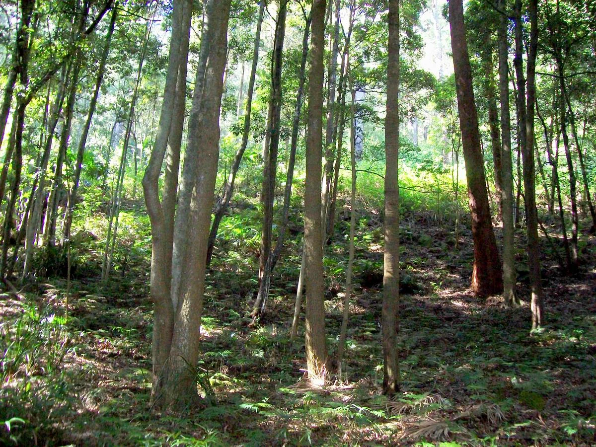
Looking into a sun-dappled temperate rainforest in Garawarra State Conservation Area with tall, thin Sassafras tree trunks and lush undergrowth.
Sassafras trees in the Camp Gully rainforest within Garawarra State Conservation Area.

Garawarra State Conservation Area history and protected-area timeline

Garawarra was gazetted as a conservation area in December 1987, formalising protection for a landscape that had long functioned as a vegetated buffer between Sydney's southern suburbs and the Royal National Park.

Its significance was given broader recognition in September 2006 when the reserve, together with the adjoining Royal National Park, was added to the Australian National Heritage List. The listing highlighted the joint area's natural values, including its sandstone vegetation communities, rainforest patches, and its role in conserving habitat close to a major Australian city. Since gazetting, the reserve has remained under the management of the NSW National Parks and Wildlife Service, which oversees conservation, fire management, and visitor access in coordination with the Royal National Park.

Garawarra State Conservation Area landscape and geographic character

The landscape of Garawarra is shaped by the familiar sandstone terrain of the Sydney Basin, with exposed ridges, deeply weathered slopes, and sheltered creek lines. Hawkesbury Sandstone dominates the upper ground, while rocks of the Narrabeen group appear in lower sections and along drainage lines, contributing to soil variability and, in turn, to the diversity of vegetation above.

The topography alternates between open ridgetops and narrow, sheltered gullies such as Camp Gully. Ridgetops tend to be dry and rocky, supporting shallow soils and exposed outcrops, while the gullies accumulate leaf litter and moisture, providing conditions for tall trees and rainforest species. Creeks running through these gullies, including Camp Gully Creek, create small but ecologically valuable refuges for moisture-dependent species within an otherwise dry landscape.

From an experiential standpoint, Garawarra offers a compact but layered terrain. Visitors move through open heath on the heights, descend into taller eucalyptus forest in the mid-slopes, and finally enter the cool, shaded atmosphere of warm temperate rainforest along the creeks. The result is a reserve where small distances translate into distinct ecological zones, characteristic of the broader Illawarra edge of the Sydney region.

Garawarra State Conservation Area ecosystems, habitats, and plant life

Garawarra's ecological character is defined by the close juxtaposition of multiple vegetation types within a small area. Dry sandstone heath dominates the ridgetops, sustained by plants adapted to shallow, nutrient-poor soils and periodic drought. Eucalyptus woodland and wet sclerophyll forest occupy intermediate slopes with deeper soils, while the most sheltered gullies support warm temperate rainforest with a surprisingly sub-tropical influence.

The heath communities include characteristic Sydney sandstone species such as Banksia, Boronia, Leptospermum, Epacris, Acacia, and members of the pea family, with seasonal highlights including Flannel Flowers and Christmas bells. The eucalyptus woodland adds species such as Sydney Red Gum, dwarf apple, Red and Yellow Bloodwoods, and Sydney peppermint. In the wetter forests, large trees including blackbutt, Sydney blue gum, turpentine, and grey ironbark rise above 30 metres, forming a structurally complex canopy.

The rainforest patches are particularly notable. Although they resemble Illawarra warm temperate rainforest at first glance, they incorporate an unusually rich mix of sub-tropical elements. Beyond sassafras and Jackwood, species such as Small-leaved Fig, Bollygum, White Hazelwood, Brush Bloodwood, Citronella, Native Tamarind, and Myrtle Ebony contribute to a forest composition that stands out for its diversity within the Sydney region.

Garawarra State Conservation Area wildlife and species highlights

Garawarra supports a rich community of native fauna, particularly in its rainforest patches and wet sclerophyll forests. Birdlife is one of the reserve's standout features, with rainforest-dependent birds being especially well represented in the sheltered gullies and along creek lines.

Two of the park's most recognisable animals are the Superb Lyrebird and the Short-beaked Echidna, both of which are commonly encountered by visitors. The reserve also hosts a variety of frogs and reptiles, which benefit from the moist conditions of the gullies and the breeding habitat provided by creeks such as Camp Gully Creek. Snail species such as Meridolum marshalli, recorded in the Camp Gully Creek area, illustrate the invertebrate diversity within the reserve.

As with much of the surrounding Sydney region, wildlife in Garawarra is shaped by the proximity of urban development. The reserve's role as a connected habitat block alongside the Royal National Park gives its fauna access to a larger landscape, increasing resilience and supporting populations of species that would struggle in more isolated fragments.

Garawarra State Conservation Area conservation status and protection priorities

Garawarra's conservation significance rests on its ability to retain a high diversity of native vegetation types on the edge of a major metropolitan area. The reserve protects heathland, eucalyptus forest, and rainforest communities that have otherwise been reduced or fragmented across much of the Sydney Basin.

Joint listing on the Australian National Heritage List with the Royal National Park in 2006 recognised the combined area as a place of outstanding natural heritage value. The listing emphasised the integrity of the vegetation communities, the presence of rare ecological associations, and the landscape's significance for biodiversity conservation within an urban context.

Management by the NSW National Parks and Wildlife Service focuses on maintaining these vegetation communities, controlling threats such as invasive species and inappropriate fire regimes, and coordinating ecological management with the adjoining Royal National Park. By functioning as a buffer and extension of the larger park, Garawarra increases the effective size and connectivity of protected habitat in the southern Sydney region.

Garawarra State Conservation Area cultural meaning and human context

Garawarra lies within a landscape that has long been valued for its proximity to Sydney, with the Royal National Park to which it adjoins being one of Australia's earliest and most visited national parks. The reserve itself contributes to a broader cultural tradition of bushwalking, nature observation, and weekend recreation that has shaped Sydney's relationship with its surrounding bushland.

The area also occupies a transitional zone between metropolitan Sydney and the Illawarra, an edge region that has historically supported a mix of urban, industrial, and rural land uses. By remaining forested while so much of the surrounding country has been altered, Garawarra carries the cultural weight of a familiar natural landmark on the city's edge, valued both for its scenery and for its accessibility from surrounding suburbs.

Top sights and standout views in Garawarra State Conservation Area

Among Garawarra's most distinctive features are the warm temperate rainforest patches with their surprisingly sub-tropical species mix, including Small-leaved Fig, Citronella, and Native Tamarind alongside typical Illawarra species such as sassafras and Jackwood. The tall wet sclerophyll forests, with emergent trees exceeding 30 metres, and the seasonal wildflower displays on the sandstone heath equally stand out within the Sydney Sandstone context.

The reserve's integration with the Royal National Park, its joint Australian National Heritage listing, and its position on the boundary of Australia's largest city give Garawarra an outsized conservation role despite its modest size. The combination of heathland, forest, rainforest, creeks, and sandstone terrain in a single accessible location is unusual within the greater Sydney region.

Best time to visit Garawarra State Conservation Area

Late winter and early spring are widely regarded as the most rewarding time to experience Garawarra, when the sandstone heath comes alive with wildflowers, including Banksia species, Christmas bells, Flannel Flowers, and a range of pea-family plants. Cooler temperatures also make walking in the more open forest and heath areas more comfortable and increase the chances of seeing active wildlife, including lyrebirds foraging through the undergrowth.

The warm temperate rainforest pockets, however, retain their character throughout the year and are particularly inviting on warmer days, where shaded gullies such as Camp Gully offer a cool contrast to surrounding exposed ridges. Rainfall is distributed across the year, so visitors should generally expect variable conditions; planning around drier spells within the cooler months can offer the most comfortable combination of flowering displays and track conditions.

Monthly climate preview

Long-term representative temperature and precipitation averages across the protected landscape

Garawarra State Conservation Area Annual Climate Normals and Temperature Rhythms

Garawarra State Conservation Area displays a measured annual temperature range alongside recorded monthly precipitation patterns at its representative coordinate. Reviewing the complete twelve-month climatology profile allows analysts to evaluate detailed temperature variations and precipitation shifts across the conservation area.
Annual mean18 °C
14 °C23 °C
Jan23°
Feb23°
Mar22°
Apr20°
May17°
Jun15°
Jul14°
Aug14°
Sep16°
Oct18°
Nov20°
Dec21°
Warmest month
January

22.7 °C

Coolest month
July

13.8 °C

Wettest month
February

4.4 mm/day

Driest month
July

1.6 mm/day

Park location guide

Geography guide, regional context, and park location map for Garawarra State Conservation Area

Garawarra State Conservation Area park geography, regions, and map view in Australia

Understand where Garawarra State Conservation Area sits in Australia through a broader geographic reading of the surrounding landscape, nearby location context, and its mapped position within the national park landscape.

How Garawarra State Conservation Area fits into Australia

Australia is a constitutional monarchy and federal parliamentary democracy comprising six states and ten territories. With a population of nearly 28 million, it is one of the world's most urbanised countries, with most people concentrated on the eastern seaboard. The country has a high Human Development Index and is known for its cultural diversity, ancient Aboriginal heritage, and unique wildlife.

Wider geography shaping Garawarra State Conservation Area in Australia

Australia occupies the entire Australian continent, the island of Tasmania, and numerous smaller islands. It is the world's flattest and driest inhabited continent, featuring vast deserts in the interior (the Outback), tropical rainforests along the eastern coast, and a coastline bordering the Indian and Pacific Oceans.

Map view of Garawarra State Conservation Area

Use this park location map to pinpoint Garawarra State Conservation Area in Australia, understand its exact geographic position, and read its mapped placement within the surrounding landscape more clearly.

Pigeon | © OpenStreetMap contributors

Location context for Garawarra State Conservation Area

New South Wales
Recorded earthquake history

View Historical Earthquake Records for Garawarra State Conservation Area

Explore the historical catalogue of recorded earthquakes associated with Garawarra State Conservation Area. This MoriAtlas resource maps seismic events near the reserve, offering insight into regional geological records and event history for the surrounding New South Wales landscape.

Garawarra State Conservation Area Earthquake History

Catalogued events

5 events

Strongest magnitude

Magnitude 4.2

Most recent event

May 28, 2025

This history includes earthquakes recorded inside the park or within 50 km of its borders

Visual reference collection showcasing sandstone terrain, rainforest habitats, and native vegetation.

Garawarra State Conservation Area Photos, Landscapes, and Protected Scenery

Visual records reveal the rugged Hawkesbury sandstone ridges, open heathlands, and sheltered warm temperate rainforest gullies that define the protected environment. Detailed imagery provides clear insight into the complex ecological communities and diverse plant habitats thriving on the urban fringe of Sydney.

Looking into a sun-dappled temperate rainforest in Garawarra State Conservation Area with tall, thin Sassafras tree trunks and lush undergrowth.

A close up view of a brown, coiled land snail resting on a wet, brownish-gold rock surface.

Park atlas

Compare connected conservation reserves and regional wilderness areas across the Sydney Basin

Explore Parks Near Garawarra State Conservation Area and Surrounding Protected Landscapes

Browse nearby national parks and protected areas sharing the distinctive sandstone geology and coastal forest terrain of Garawarra State Conservation Area. Evaluating these adjacent natural reserves provides a comprehensive geographic view of regional conservation networks.
National parkNew South Wales
Park boundaries overlap#1 closest

Northeast

Royal National Park National Park: Geographic Atlas and Protected Landscape Context

Explore mapped park boundaries and regional terrain.

Royal National Park is a designated national park in New South Wales, Australia, offering rich opportunities for geographic discovery and landscape context analysis. This page serves as a foundational entry for understanding the park's protected status, its distinct natural terrain, and its mapped presence within the regional geography. Explore how this protected landscape contributes to Australia's broader atlas of natural areas.

Area
150.91 km²
Established
1879
IUCN
II
Relief
Mixed relief
State or regional parkNew South Wales
0 km away#2 closest

Southwest

Illawarra Escarpment State Conservation Area: Mapped Geography and Protected Area Context

Regional protected landscape and sandstone escarpment in New South Wales

Examine the geographic structure and landscape composition of the Illawarra Escarpment State Conservation Area. This resource maps the 40-kilometre stretch of sandstone cliffs and forested foothills that rise above the Illawarra coastal plain, providing a detailed look at the six sections that constitute this unique state conservation land.

Area
27.72 km²
Established
1980
Relief
Mountain
Climate
Temperate
National parkNew South Wales
0.2 km away#3 closest

Northwest

Heathcote National Park: Discover the Hawkesbury Sandstone Terrain and Mapped Protected Boundaries

Explore the rugged gorges and regional geography of this New South Wales national park.

Heathcote National Park preserves a significant example of the Sydney region's characteristic Hawkesbury sandstone landscape, presenting a terrain of deeply incised creek gorges and rocky valleys. Located in New South Wales, this protected national park offers valuable insights into regional geography and the mapped distribution of natural landscapes. Its rugged terrain and diverse ecosystems make it a key destination for understanding the protected area context of Australia's eastern seaboard.

Area
26.79 km²
Established
1943
IUCN
II
Relief
Mixed relief
National parkNew South Wales
5.7 km away#4 closest

West

Dharawal National Park: Sandstone Landscapes and Upland Swamp Ecosystem Atlas

Discover mapped protected area boundaries and unique biodiversity.

Dharawal National Park, situated in New South Wales, is a significant protected area distinguished by its globally important upland swamp ecosystems, which exhibit the highest species richness of shrub and sedge communities found anywhere on Earth. This national park features a varied terrain, from steep gorges and waterfalls to sandstone woodlands and rainforest valleys, all contributing to its exceptional biodiversity and status as a crucial koala habitat within southern Sydney. Its landscape context on the Woronora Plateau provides a unique geographic perspective for understanding protected Australian natural areas.

Area
65.08 km²
Established
2012
IUCN
II
Relief
Mixed relief
A watercolor painting showing a panoramic view of soft green hills, sparse trees, and a flat foreground against a pale, warm sky.
Nature reserveNew South Wales
About 12 km away#5 closest

North

Lucas Heights Conservation Area: Protected Bushland Geography and Regional Atlas Context

Nature reserve located in the Sutherland Shire, New South Wales

Spanning over 111 hectares, Lucas Heights Conservation Area functions as a crucial nature reserve near the Georges River catchment. The site documents the convergence of distinct geological substrates, resulting in a rich mosaic of woodland, heath, and sedgeland. Beyond its role as a botanical refuge, the area encompasses significant Aboriginal heritage sites, including grinding grooves and rock art, reflecting the deep cultural history of Gandangara country.

Area
1.117 km²
Established
2002
Relief
Upland
Climate
Temperate
National parkNew South Wales
16 km away#6 closest

North

Georges River National Park: Protected Landscape and Geographic Context in New South Wales

Mapped terrain, sandstone woodlands, and key wetland habitats.

Georges River National Park, located within New South Wales, Australia, serves as a crucial protected natural area. Its 514 hectares encompass diverse terrain shaped by the Georges River, featuring significant mangrove swamps, salt marshes, and exposed sandstone woodlands characteristic of the Sydney region. This park's atlas value lies in its role preserving vital ecosystems, supporting a notable array of vertebrate and bird species, and showcasing unique natural landscapes easily explored through mapped terrain and geographic context.

Area
5.14 km²
Established
1992
IUCN
II
Relief
Lowland
National parkNew South Wales
About 17 km away#7 closest

Northwest

Georges River Koala National Park: A Protected Landscape for Critical Koala Habitat in New South Wales

Mapped geography and unique wildlife sanctuary.

Georges River Koala National Park represents a key protected area within New South Wales, specifically designated for safeguarding critical koala populations. This national park offers an invaluable insight into the region's undulating woodland terrain and the Georges River corridor's role in providing essential habitat. Understand the park's landscape character, its mapped boundaries, and its importance as a sanctuary for chlamydia-free koala colonies.

Area
18.3 km²
Established
2023
IUCN
II
Relief
Lowland
National parkNew South Wales
21 km away#8 closest

Northeast

Kamay Botany Bay National Park: National Park Geography and Protected Landscape Atlas

Mapped protected areas and natural terrain in New South Wales.

Kamay Botany Bay National Park offers a unique window into Australia's protected natural areas. This entry focuses on its identity as a national park, detailing its geographic position within New South Wales and the mapped context of its protected boundaries. Gain insight into the park's landscape features and its significance within a broader atlas of conservation lands, facilitating a structured approach to understanding its unique natural terrain.

Area
4.56 km²
Established
1984
IUCN
V
Relief
Mixed relief

Common questions about visiting, size, designation, and location context for Garawarra State Conservation Area

Garawarra State Conservation Area FAQs for park facts, access, geography, and protected area context

Find quick answers about Garawarra State Conservation Area, including protected-area facts, park geography, trail and visitor context, and how the park fits into its surrounding country and regional landscape.
MoriAtlas Explorer

Continue Your Protected Areas Search Across the Global Atlas

Deepen your exploration by continuing the structured search for national parks and protected areas worldwide. Utilize the comprehensive filtering capabilities to compare different conservation landscapes and refine your understanding of global park geography. Discover more about the distribution and characteristics of protected natural areas.

Global natural geography