Mori Atlas logo
Wildlife reserveGearhart Mountain Wilderness

Tracing the glaciated terrain and dry pine forest mosaic of an established wilderness boundary.

Gearhart Mountain Wilderness: A Protected High Mountain Landscape in South Central Oregon

Gearhart Mountain Wilderness encompasses 22,823 acres within the Fremont Winema National Forest, representing a vital transition zone between the Oregon high desert and the southern Cascades. The landscape is defined by the 8,364-foot Gearhart Mountain, surrounded by glacially carved cirques, open mountain meadows, and expansive dry pine forests that host diverse bird and fish species. This protected area offers a high-elevation geographic profile where ancient ice-carved basins descend into dense stands of lodgepole and whitebark pine, providing a unique vantage point for observing the broader volcanic and mountain ranges of the Pacific Northwest.

wilderness areadry pine forestmountain meadowsglacial cirquessouthern Cascades fringeheadwater streams

Gearhart Mountain Wilderness

Wildlife reserve

Park overview

Structured park overview, official facts, and landscape profile for Gearhart Mountain Wilderness

Gearhart Mountain Wilderness park facts, protected area profile, and essential visitor context

Review the core facts for Gearhart Mountain Wilderness, including designation, size, terrain, visitor scale, habitats, and operating context in one park-focused overview.

About Gearhart Mountain Wilderness

Gearhart Mountain Wilderness lies in the forested heart of south-central Oregon, where the dry interior country of the Great Basin meets the forested southern fringe of the Cascade Range. Spread across roughly 22,823 acres in Lake and Klamath counties, it is entirely contained within the Fremont-Winema National Forest and is managed as a congressionally designated wilderness under the U.S. Forest Service's Bly Ranger District.

The wilderness is anchored by Gearhart Mountain itself, which rises to 8,364 feet, the high point not only of the protected area but of the surrounding landscape as well. From its summit, visitors can look out over an exceptionally wide geographic sweep, from the volcanic Steens Mountain in the east to the Cascade peaks of central Oregon to the west, with the California volcano Lassen Peak on the southern horizon and the Three Sisters to the north. The terrain below folds into a varied pattern of high mountain meadows, glacial cirques, headwall cliffs, and deeply cut drainage valleys, with small streams issuing from the bases of the cliffs and ridges.

Ecologically, the wilderness sits squarely within the dry pine belt that characterizes this transition zone. Lower slopes are dominated by a mix of white fir, ponderosa pine, and lodgepole pine, while higher elevations give way to nearly pure stands of lodgepole and whitebark pine, with scattered sugar pine and incense-cedar mixed in. Where soils and snowmelt collect, open meadows form a softer contrast to the surrounding forest, with aspen groves, lush grasses, and seasonal wildflowers. The area still contains some old-growth stands, although large patches of lodgepole pine have been affected by mountain pine beetle outbreaks in recent years.

Beyond its scenic and ecological character, the wilderness also has a clear human story. Gearhart Mountain takes its name from two brothers, James P. Gearhart and William H. Gearhart, who ran cattle in the area in the late nineteenth century, between about 1873 and 1882. Federal protection of the landscape arrived in 1943, decades later, when it was established as a Wild Area. Its modern wilderness identity was confirmed through the 1964 Wilderness Act, and in 1984 an additional 4,144 acres were incorporated to form the present-day boundaries. Trails such as Deming Creek, Lookout Rock, and North Fork Sprague converge near the summit and support a quiet, lightly developed recreational setting shaped around hiking, horseback riding, hunting, fishing, and wildlife watching rather than built-up visitor infrastructure.

Quick facts and research context for Gearhart Mountain Wilderness

Gearhart Mountain Wilderness is a federally designated wilderness of about 22,823 acres in Lake and Klamath counties of south-central Oregon. It sits within the Fremont-Winema National Forest and is administered by the U.S. Forest Service through the Bly Ranger District.

First protected in 1943 as a Wild Area and later confirmed as wilderness under the 1964 Wilderness Act, the area was expanded by roughly 4,144 acres in 1984. Its highest point, Gearhart Mountain, reaches 8,364 feet and overlooks the Steens Mountain, Cascade peaks, Three Sisters, and Lassen Peak regions. The wilderness is recognized for its dry pine forests, glaciated basins, mountain meadows, and headwater streams that support native trout populations.

Protection and recognition

Documented terrestrial protection scope and 1964 establishment records

Gearhart Mountain Wilderness Protection Status and Designation History

Gearhart Mountain Wilderness maintains a documented terrestrial protection scope established in the year 1964. Conservation records outline the official designation timeline and management framework without international recognition sources.

Protection details

Protection scope
Terrestrial
Designated year
1964
Transboundary protection
No
Park context

Deeper park guide and search-rich context for Gearhart Mountain Wilderness

Gearhart Mountain Wilderness history, landscape, wildlife, and travel context

Explore Gearhart Mountain Wilderness through its history, landscape character, ecosystems, wildlife, conservation priorities, cultural context, and seasonal travel timing in a structured park guide built for atlas discovery and search intent.

Why Gearhart Mountain Wilderness stands out

Gearhart Mountain Wilderness is best known as a high-elevation dry pine wilderness occupying Oregon's desert-to-coastal transition zone. Its defining features are high mountain meadows, glacially carved cirques, and a continuous forest mosaic where species composition shifts with water availability, from white fir and ponderosa pine on the lower slopes to nearly pure lodgepole and whitebark pine stands near the summit. The wilderness is also recognized for the panoramic views from the summit of Gearhart Mountain, looking out across the Steens Mountain, the southern Cascade peaks, the Three Sisters, and the distant silhouette of Lassen Peak. Together with its older 1943 protection date and its status as one of Oregon's established congressionally recognized wildernesses, these landscape traits give the area a strong identity within the broader southern Cascades and Fremont-Winema forest system.
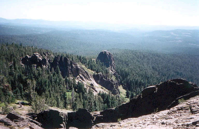
An expansive high-angle view of a dense coniferous forest with prominent rocky outcrops, ridges, and valleys in Gearhart Mountain Wilderness.
A wide view overlooking the forested landscape and rock formations within Gearhart Mountain Wilderness.

Gearhart Mountain Wilderness history and protected-area timeline

Gearhart Mountain Wilderness has a layered human and institutional history that begins with the late nineteenth-century cattle trade and stretches into the modern American wilderness preservation system.

The mountain itself takes its name from two brothers, James P. Gearhart and William H. Gearhart, who raised and traded cattle in the surrounding area from about 1873 to 1882. Their activity is the most concrete early documented human presence in what is now the wilderness, and the name has stuck to the landscape ever since.

Federal protection arrived much later. In 1943, the area was established as a Wild Area, making it one of the older formally protected landscapes in south-central Oregon. Its modern status as a recognized wilderness was confirmed when the Wilderness Act of 1964 established the National Wilderness Preservation System, under which Gearhart Mountain was formally designated. In 1984, the area was expanded by an additional 4,144 acres, bringing it to its present size of about 22,823 acres and reinforcing its role within the Fremont-Winema National Forest.

Throughout these changes, the wilderness has remained under U.S. Forest Service management, specifically within the Bly Ranger District, and has continued to function as a relatively lightly visited backcountry landscape rather than a heavily developed recreation destination.

Gearhart Mountain Wilderness landscape and geographic character

Gearhart Mountain Wilderness occupies the desert-to-coastal transition zone of south-central Oregon, a transitional band where the dry interior forests meet the moister, higher country of the southern Cascade Range. The result is a landscape of broad ridges, glacially shaped basins, and long, even slopes that descend into forested valleys.

The dominant single feature is Gearhart Mountain itself, whose summit reaches 8,364 feet. Around it the terrain forms a classic glaciated high-country pattern: rounded ridges, open bowls, and bowl-shaped cirques carved into the upper slopes by ancient ice. Below these cirques, the cliffs and headwalls give rise to numerous small streams whose headwaters gather in the meadows and forest understories of the lower terrain.

From the summit, the visual range is unusually wide for a wilderness of this size. To the east lie the volcanic mass of Steens Mountain in the high desert country of far southeastern Oregon. To the west rise the Cascade peaks, while to the north the Three Sisters complex dominates the horizon of central Oregon's High Cascades, and to the south, on a clear day, the cone of Lassen Peak is visible in northern California. This combination of high open vistas immediately above and dense forested slopes immediately below gives the wilderness a strong sense of elevation contrast and visual breadth.

Gearhart Mountain Wilderness ecosystems, habitats, and plant life

Ecologically, Gearhart Mountain Wilderness sits within a continuous, dry pine forest that extends across the broader transition zone of south-central Oregon. Unlike coastal forests, the vegetation here is shaped more by limited water than by temperature, and the species mix shifts with elevation and moisture availability rather than along simple elevation bands.

On the lower slopes, the forest is dominated by white fir, with ponderosa pine and lodgepole pine mixed throughout. At higher elevations, lodgepole pine becomes dominant and shares the canopy with whitebark pine, producing the almost pure conifer stands typical of this elevation range in the southern Cascades. Scattered inclusions of sugar pine and incense-cedar add compositional variety in localized sites where conditions favor them.

Open meadows form a defining non-forest element within the wilderness. These meadows support lush green ground cover, stands of aspen, and a rich wildflower display during the growing season. Along the small streams that drain the higher terrain, riparian zones support tag alder, willow, and a diverse understory of moisture-loving plants. The wilderness still contains some old-growth stands, though recent decades have seen substantial mortality in lodgepole pine due to mountain pine beetle outbreaks, leaving large areas of standing dead trees within the otherwise intact forest matrix.

Gearhart Mountain Wilderness wildlife and species highlights

The wildlife of Gearhart Mountain Wilderness reflects its position as a transition-zone forest, with a mix of dry-country mammals and a notable diversity of forest-interior birds, supported by healthy headwater stream systems for aquatic species.

Among the larger mammals, deer, elk, black bear, mountain lion, and coyote all occur within the wilderness, along with smaller mammals such as the golden-mantled ground squirrel. The combination of meadow edge and forest cover provides a particularly productive habitat pattern for deer and elk, while the rougher, more remote terrain gives mountain lion and black bear room to range widely.

The birdlife is one of the richest features of the area. Common forest birds include several woodpecker species, mountain chickadees, finches, Canada jays, Steller's jays, dark-eyed juncos, common ravens, brown creepers, golden-crowned kinglets, red-breasted nuthatches, Cassin's vireos, yellow-rumped warblers, hermit warblers, Pacific-slope flycatchers, dusky flycatchers, sooty grouse, Clark's nutcrackers, and red-tailed hawks. The presence of both true forest-interior species and more open-country species gives the wilderness a notably diverse avifauna.

The streams of the wilderness support a similarly varied cold-water fish community. Bull trout inhabit the headwater reaches, while rainbow trout and brook trout occupy lower sections of the system. Blue Lake, within the area, is also stocked annually with rainbow trout, supporting the recreational fishery that is part of the wilderness's broader use.

Gearhart Mountain Wilderness conservation status and protection priorities

Gearhart Mountain Wilderness is significant from a conservation standpoint both because of its age as a protected landscape and because of the ecological values it preserves in the dry pine transition zone of south-central Oregon.

Designated in 1943 as a Wild Area and later confirmed as a congressionally designated wilderness under the 1964 Wilderness Act, the area is one of the older formally protected wild landscapes in the region. Its 1984 expansion consolidated the protected area around the upper Gearhart Mountain block, strengthening its ecological coherence. As part of the National Wilderness Preservation System, the area receives the elevated protection typical of congressionally designated wildernesses, including limits on mechanized use, permanent protection from development, and an emphasis on preserving wilderness character.

The wilderness conserves an unusually intact example of the dry, water-limited pine forests that stretch across the southern Cascade transition zone, including conifer composition that varies with elevation and water availability. It also preserves meadow communities, aspen stands, and riparian systems along the headwater streams, all of which support biodiversity at multiple scales. The presence of old-growth stands, the habitat provided by large snags and standing dead trees after beetle outbreaks, and the headwater populations of sensitive native fish such as bull trout further reinforce the conservation value of the unit.

Gearhart Mountain Wilderness cultural meaning and human context

The cultural footprint of Gearhart Mountain Wilderness is modest but genuine, anchored in the late nineteenth-century cattle herding activity of the Gearhart brothers. Family and place-name memory serves as the main surviving thread connecting the wilderness to early European-American land use in the area.

Today, the cultural connection to the landscape is mostly recreational and stewardship-oriented rather than residential or industrial. Hiking, hunting, horseback riding, fishing, and camping traditions in the southern Oregon national forests, including the broader Fremont-Winema system, give the wilderness a place in the regional outdoor culture of Lake and Klamath counties. The wilderness remains devoid of permanent human settlement, and its identity is shaped far more by natural processes and federal protection than by ongoing human habitation.

Top sights and standout views in Gearhart Mountain Wilderness

Gearhart Mountain Wilderness is anchored by the 8,364-foot summit of Gearhart Mountain, whose broad views reach across the Steens Mountain, the Cascades, the Three Sisters, and even toward Lassen Peak. The wilderness's glacially carved cirques, open mountain meadows, and dry pine forests form the core of its scenic identity.

Other notable features include about 20 miles of established trails (notably the Deming Creek, Lookout Rock, and North Fork Sprague trails), headwater streams with native bull trout, and Blue Lake, which is stocked annually with rainbow trout. The area's continuous stands of dry-transition pine forest, partial old-growth remnants, and richer-than-expected bird diversity round out a set of highlights that distinguish it from neighboring landscapes.

Best time to visit Gearhart Mountain Wilderness

Summer is the most practical window for visiting Gearhart Mountain Wilderness, when the snow has largely melted off the lower and middle elevations and the trail network becomes accessible to hikers and horseback riders. Wildflower-filled meadows and aspen stands are at their most visible during this season, and the panoramic views from the summit are most reliably clear when the higher country is snow-free.

Shoulder seasons can also be attractive, with quieter conditions and crisp air, though snow lingers at higher elevations into late spring and returns early in autumn. Winter transforms the higher country into a snow-covered backcountry setting, with travel typically requiring cross-country skills rather than trail use. Wildlife viewing can be productive across multiple seasons, but the combination of accessible trails, open meadows, and stable weather makes summer the most generally suitable time for most visitors to experience the wilderness's defining features.

Monthly climate preview

Long-term representative point measurements tracking annual temperature and precipitation patterns

Gearhart Mountain Wilderness Climate Normals, Temperature, and Precipitation Rhythm

Gearhart Mountain Wilderness records long-term monthly temperature and precipitation data derived from representative coordinate sampling across the protected terrain. Analyzing twelve-month climate normals reveals the measured annual thermal rhythm and moisture distribution established by multi-year baseline averages.
Annual mean7 °C
-3 °C19 °C
Jan-2°
Feb-1°
Mar
Apr
May10°
Jun14°
Jul19°
Aug18°
Sep14°
Oct
Nov
Dec-3°
Warmest month
July

19.3 °C

Coolest month
December

-2.8 °C

Wettest month
December

2.3 mm/day

Driest month
August

0.3 mm/day

Park location guide

Geography guide, regional context, and park location map for Gearhart Mountain Wilderness

Gearhart Mountain Wilderness park geography, regions, and map view in United States of America

Understand where Gearhart Mountain Wilderness sits in United States of America through a broader geographic reading of the surrounding landscape, nearby location context, and its mapped position within the national park landscape.

How Gearhart Mountain Wilderness fits into United States of America

The United States of America is a federal presidential republic and one of the world's largest countries by area and population. It consists of 50 states across a vast territory spanning multiple time zones, with its capital in Washington, D.C. and largest city in New York City. The nation has a diverse economy, influential political system, and significant cultural and military presence globally.

Wider geography shaping Gearhart Mountain Wilderness in United States of America

The United States occupies a vast territory in North America, bordered by Canada to the north and Mexico to the south. The 48 contiguous states stretch from the Atlantic to the Pacific Ocean, while Alaska occupies the northwestern region and Hawaii is an archipelago in the Pacific. The country encompasses diverse terrain including the Rocky Mountains, Appalachian Mountains, Great Plains, and extensive river systems.

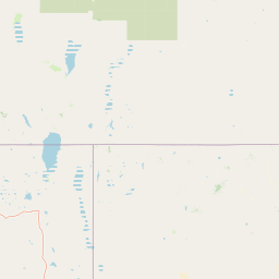
Map view of Gearhart Mountain Wilderness

Use this park location map to pinpoint Gearhart Mountain Wilderness in United States of America, understand its exact geographic position, and read its mapped placement within the surrounding landscape more clearly.

Pigeon | © OpenStreetMap contributors

Location context for Gearhart Mountain Wilderness

Oregon
Recorded earthquake history

Examine Recorded Earthquake History Near Gearhart Mountain Wilderness

Access the historical seismic catalogue for Gearhart Mountain Wilderness to view recorded events, magnitudes, and epicentre proximity data. MoriAtlas provides this structured overview of past regional activity for further geographic exploration of the southern Cascades area.

Gearhart Mountain Wilderness Earthquake History

Catalogued events

2 events

Strongest magnitude

Magnitude 3.3

Most recent event

Mar 10, 2026

This history includes earthquakes recorded inside the park or within 50 km of its borders

Visualizing the dry pine forests, glacial cirques, and high mountain meadows of south-central Oregon

Gearhart Mountain Wilderness Photos and Landscape Scenery Exploration

Visual documentation captures the high-elevation dry pine forests, glacially carved cirques, and rugged mountain terrain defining Gearhart Mountain Wilderness. Studying these protected-area photographs reveals the distinct transitional landscape and expansive summit vistas found across the southern Cascades fringe.

An expansive high-angle view of a dense coniferous forest with prominent rocky outcrops, ridges, and valleys in Gearhart Mountain Wilderness.

Park atlas

Compare regional mountain terrain, dry pine forests, and nearby protected areas.

Other Parks Near Gearhart Mountain Wilderness And Surrounding Protected Landscapes

Browse protected areas and wilderness reserves sharing the regional geography of Gearhart Mountain Wilderness. Comparing adjacent mountain terrain and dry forest zones helps map the broader protected landscape.
Protected landscapeCalifornia
52 km away#1 closest

South

Modoc National Forest: Protected Landscape and Warner Mountains Geography

High desert volcanic terrain in northeastern California

Modoc National Forest encompasses a massive expanse of volcanic plateaus and rugged mountain ridges in the northeastern corner of California. This protected area offers significant geographic variety, transitioning from arid sagebrush basins to lush, high-elevation conifer forests. It serves as a vital natural landscape, home to the South Warner Wilderness and large stands of old-growth timber, reflecting the unique geologic history of the regional lava flows.

Area
6,695.09 km²
Established
1904
Relief
Mountain
Access
Moderate access
National parkOregon
93 km away#2 closest

Northwest

Crater Lake National Park: Oregon National Park Atlas of Volcanic Landscapes

Explore mapped boundaries and unique caldera geography.

Crater Lake National Park represents a significant protected area within Oregon, defined by the dramatic volcanic caldera it contains. This national park is celebrated for its exceptionally deep, clear blue lake, formed by the collapse of Mount Mazama, offering a unique subject for geographic and landscape study. Users can explore its mapped boundaries and understand its position within the broader atlas of protected lands and mountainous terrain of the Cascade Range.

Area
741.48 km²
Established
1902
IUCN
II
Visitors
527K annual
Wildlife reserveOregon
95 km away#3 closest

West

Mountain Lakes Wilderness: Geographic Atlas of Oregon's Glacial Volcanic Reserve

Mapping the volcanic cirques and square boundaries of the southern Cascades.

Mountain Lakes Wilderness serves as a primary geographic anchor in the southern Cascades, where shield volcanoes meet glacially carved basins. This protected area contains over twenty lakes situated in high-altitude cirques near the summits of volcanic peaks like Aspen Butte. The area is defined by its distinctive square survey-township boundary, providing a clear footprint of wilderness conservation within the larger Fremont-Winema National Forest terrain.

Area
93 km²
Established
1964
IUCN
Ib
Relief
Mountain
An artistic watercolor illustration showing a line of green evergreen trees in the foreground with hazy, distant mountains in the background against a light, neutral sky.
Protected landscapeOregon
104 km away#4 closest

West

Rogue River, Siskiyou National Forest: Mapped Geography and Protected Area Overview

Tracing volcanic peaks and river-carved mountain terrain in Oregon

Spanning nearly 7,300 square kilometers, the Rogue River, Siskiyou National Forest acts as a crucial ecological anchor in the Pacific Northwest. This overview details its unique mountain geography, the extensive wilderness tracts within its boundaries, and the river systems that define its mountainous character.

Area
6,973.46 km²
Established
2004
Visitors
915K annual
Relief
Mountain
Protected landscapeCalifornia
105 km away#5 closest

Southwest

Butte Valley National Grassland: Geographic Overview and Protected Landscape Mapping

High-desert sagebrush steppe in Northern California

Butte Valley National Grassland is a singular protected landscape in northern California, known for its expansive sagebrush steppe and dry lakebed terrain. Centered in the Klamath River basin, the grassland provides an essential high-desert habitat framed by the dramatic volcanic presence of the Cascade Range and Mount Shasta. This atlas entry details the geography, soil composition, and mountain-framed boundaries of this unique protected area.

Area
74.56 km²
Established
1991
Relief
Upland
Climate
Temperate
A watercolor illustration of rolling green hills, a small body of water, and distant mountain peaks against a plain white background.
Wildlife reserveOregon
108 km away#6 closest

Northwest

Mount Thielsen Wilderness: Protected Volcanic Terrain and Glacial Landscapes in Oregon

Southern Cascade Range mountain and forest geography

Mount Thielsen Wilderness offers a compact yet dramatic study of southern Cascade topography. Dominated by its signature lightning-struck volcanic peak, the area encompasses a complex network of glacial cirques, deep valleys, and high-altitude forest zones. This map-rich entry point provides a closer look at the protected boundaries and natural geological features that define this significant segment of Oregon wilderness.

Area
223 km²
Established
1984
IUCN
Ib
Relief
Mountain
A soft watercolor painting depicting a serene landscape with gentle green hills, a small forest, and a calm lake at sunrise or sunset.
Protected landscapeCalifornia
116 km away#7 closest

Southwest

Shasta, Trinity National Forest: Mapping the Protected Landscapes of Northern California

Volcanic peaks, expansive reservoirs, and rugged mountain wilderness

Spanning over two million acres, Shasta, Trinity National Forest represents a major protected landscape in Northern California. The geography includes the iconic Mount Shasta volcano and the complex shoreline of Shasta Lake, while hosting expansive wilderness areas and diverse terrain ranging from oak-forested foothills to alpine meadows.

Area
8,942.87 km²
Established
1954
Relief
Mountain
Climate
Temperate
Wildlife reserveOregon
131 km away#8 closest

Northwest

Rogue-Umpqua Divide Wilderness: Protected Ridge Landscape and Watershed Geography

High-country wilderness area in southwestern Oregon

Rogue-Umpqua Divide Wilderness preserves a dense, high-elevation ridge environment that separates the Rogue and Umpqua river drainages. Featuring a complex mix of volcanic and sedimentary rock outcrops within a continuous conifer canopy, the area offers a unique look at forest ecology in the Klamath Mountains. The geography provides extensive views across both watersheds and stands as a primary example of protected montane forest terrain within the Oregon landscape.

Area
134 km²
Established
1984
IUCN
Ib
Water
Minor water

Common questions about visiting, size, designation, and location context for Gearhart Mountain Wilderness

Gearhart Mountain Wilderness FAQs for park facts, access, geography, and protected area context

Find quick answers about Gearhart Mountain Wilderness, including protected-area facts, park geography, trail and visitor context, and how the park fits into its surrounding country and regional landscape.
MoriAtlas Explorer

Continue Your Protected Areas Search Across the Global Atlas

Deepen your exploration by continuing the structured search for national parks and protected areas worldwide. Utilize the comprehensive filtering capabilities to compare different conservation landscapes and refine your understanding of global park geography. Discover more about the distribution and characteristics of protected natural areas.

Global natural geography