
Capes
Park geography
Analyzing the coastal island terrain, environmental features, and regional geography
Comprehensive Geographic Profile and Mapped Boundaries of Georgian Bay Islands National Park
Explore the structured geographic data for Georgian Bay Islands National Park located in Ontario, Canada. This profile details the 13.5 square kilometer boundary and diverse natural environment including temperate forests, wetlands, and various coastal features across the Lake Huron islands.
Related tags
Island wildernessArchipelagoGreat LakesCanadian ShieldMixed forest
Island wilderness at the gateway to Georgian Bay
Georgian Bay Islands National Park
Georgian Bay Islands National Park is a constellation of 63 small islands and island fragments scattered across the northern reaches of Georgian Bay in Southern Ontario, Canada. Established in 1929, it stands as one of Canada's older national parks and represents a rare protected area dedicated to preserving island ecosystems in the Great Lakes region. The park encompasses approximately 13.5 square kilometers of land distributed among islands that can only be reached by boat, creating a distinctive wilderness experience centered on water-based access and isolated natural environments.
- Location
- Canada
- Park type
- National park
- Established
- 1929
- Area
- 13.5 km²
Location overview
An island and coastal protected area in Ontario, Canada
Geographic Setting of Georgian Bay Islands National Park
Georgian Bay Islands National Park is located within the province of Ontario in Canada. The protected area features coastal and island status without any transboundary jurisdiction.
- Countries
- Canada
- Regions
- Ontario
- Primary location
- Ontario
- Geographic setting
- Coastal · Island
Boundary and coordinates
Spatial footprint and coordinate limits of the 13.5 square kilometer reserve
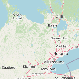
Georgian Bay Islands National Park Boundary Map and Geographic Limits
The interactive boundary geometry provides clear spatial context for the scattered island territory. Accompanying spatial metrics outline the calculated total area, geographic center, and coordinate spans.
- Boundary area
- 13.1 km²
- Boundary perimeter
- 71.1 km
- Northernmost point
- 45.1121° N
- Southernmost point
- 44.8285° N
- Easternmost point
- 79.7887° W
- Westernmost point
- 80.1367° W
- Geographic centre
- 44.8805° N, 79.8695° W
- North–south span
- 31.5 km
- East–west span
- 27.5 km
Terrain and natural features
Sixteen capes, islands, and other features recorded within
Georgian Bay Islands National Park mixed terrain and features
Georgian Bay Islands National Park has mixed relief and sixteen linked features. All are recorded within the park, including Lake Huron, Bone Island, Christian Beach, multiple capes, and Tonch Point with both cape and cliff types.
Selected named natural features
Capes
Finger Point
Capes
Thumb Point
Capes
Beausoleil Point
Capes
Tonch Point
Cliffs
Tonch Point
Environmental setting
Temperate island landscapes, mixed relief, and major water presence
Georgian Bay Islands National Park Environmental Classification and Physical Setting
Recorded landscape features, temperate forest types, and coastal habitats form complementary perspectives on the physical setting of Georgian Bay Islands National Park. Structured categories connect directly to related atlas destinations across the protected area.
- Relief
- Mixed relief
- Climate
- Temperate
- Water
- Major water bodies
- Forest cover
- Partial forest
- Seasonality
- Year-round
Landscape features
Islands · Forest · Coast · Woodland · Grassland · Wetland
Habitat types
Temperate broadleaf forest · Temperate coniferous forest · Riverine habitat · Coastal habitat
Park atlas
Compare other island wilderness areas and diverse protected landscapes across the Great Lakes region and Southern Ontario.
Explore Nearby National Parks and Protected Areas Around Georgian Bay Islands National Park
After exploring Georgian Bay Islands National Park's unique island wilderness, continue your park discovery by browsing nearby protected areas and related landscapes. Trace the regional spread of national parks and other protected areas across Southern Ontario and the Great Lakes region to understand the broader conservation landscape.
Wildlife reserveOntario
About 35 km away#1 closest
East

Eleanor Island Wildlife Reserve: Protected Ontario Lake Landscape and Bird Habitat
A federal migratory bird sanctuary in the Canadian Shield
Eleanor Island is a strictly protected migratory bird sanctuary in Ontario that serves as a vital nesting ground for colonial waterbirds. Positioned within Lake Muskoka, this small but ecologically purposeful nature reserve demonstrates the importance of localized federal protection for regional breeding populations. Its status as a strict nature reserve underscores a commitment to safeguarding sensitive habitats within the broader Canadian Shield wilderness.
- Area
- 0.006 km²
- Established
- 1978
- IUCN
- Ia
- Relief
- Lowland
National parkOntario
96 km away#2 closest
West
Bruce Peninsula National Park: National Park Protected Landscape and Geographic Context in Ontario
Discover its mapped boundaries and regional landscape identity.
Bruce Peninsula National Park stands as a protected national park entity within Ontario, offering a distinct geographic profile. Its mapped boundaries and position within the regional atlas are crucial for understanding its landscape character. MoriAtlas facilitates exploration of the park's protected status and its contribution to the conservation landscape of Ontario.
- Area
- 154 km²
- Established
- 1987
- IUCN
- II
- Visitors
- 460.4K annual
National parkOntario
104 km away#3 closest
Southeast
Rouge National Urban Park: Ontario's Mapped Protected Landscape Atlas
Explore national park boundaries and regional geography.
Investigate Rouge National Urban Park, a designated national park situated in Ontario, Canada. This page provides detailed atlas-style information focusing on its mapped boundaries, regional geographic context, and its identity as a significant protected natural landscape. Understand the park's role within the broader Canadian atlas for landscape exploration.
- Area
- 79.1 km²
- Established
- 2015
- IUCN
- V
- Relief
- Mixed relief
Marine protected areaMichigan
181 km away#4 closest
West

Thunder Bay National Marine Sanctuary: Geography and Protected Maritime Landscape Context
Mapping underwater heritage in the Michigan Great Lakes region
Spanning 4,300 square miles of Lake Huron, Thunder Bay National Marine Sanctuary preserves a significant collection of shipwrecks within a glacially shaped freshwater terrain. This marine protected area offers a look at submerged geography ranging from shallow coastal bays to deep lake basins. It serves as a vital anchor for understanding maritime history and freshwater ecosystem stability across the Michigan shoreline.
- Area
- 11,000 km²
- Established
- 2000
- Relief
- Lowland
- Climate
- Temperate
Wildlife reserveOntario
About 198 km away#5 closest
Southeast
Wellers Bay National Wildlife Area: Coastal and Island Geography in Ontario
An important Great Lakes barrier beach protected reserve
Wellers Bay National Wildlife Area contains a rare collection of undeveloped shorelines, including the Baldhead peninsula and offshore islands. This protected area offers a deep look into the littoral processes of Lake Ontario, providing crucial sanctuary for waterbirds and endangered species within a fragile, compact, and natural woodland environment.
- Area
- 0.74 km²
- Established
- 1978
- IUCN
- Ia
- Scope
- Terrestrial
Marine protected areaMichigan
About 246 km away#6 closest
West
Thunder Bay National Marine Sanctuary and Underwater Preserve: Geography and Protected Area Atlas
Maritime heritage sites and glacial freshwater geography in Lake Huron, Michigan.
Situated along the rugged northeastern coast of Lake Huron, Thunder Bay National Marine Sanctuary and Underwater Preserve protects over two hundred shipwreck sites spanning nearly two centuries of maritime history. This marine protected area offers a unique intersection of submerged archaeological resources, shallow shoals, coastal marshes, and limestone bedrock, forming a vital freshwater ecosystem in the Great Lakes region of Michigan.
- Area
- 11,000 km²
- Established
- 2000
- Relief
- Lowland
- Climate
- Temperate
Wildlife reserveOntario
About 254 km away#7 closest
Southeast
Prince Edward Point National Wildlife Area: Protected Geography and Migration Hub
Coastal woodland and shoreline terrain in southeastern Ontario
Prince Edward Point National Wildlife Area is a federal reserve located on a narrow peninsula extending into Lake Ontario. This area features a diverse landscape of forest patches, open meadows, and jagged lakefront, providing critical refuge for migrating bird species. As a long-standing center for ornithological research, the site remains an essential node for understanding the regional migration patterns and natural heritage of the Great Lakes basin.
- Area
- 5.6 km²
- Established
- 1980
- IUCN
- Ia
- Relief
- Lowland
National parkOntario
271 km away#8 closest
East
Thousand Islands National Park: Exploring Ontario's Protected Landscape Geography
Discover the mapped terrain and regional context of this national park.
Uncover the protected landscape identity of Thousand Islands National Park, a key national park located in Ontario. This resource focuses on its geographic setting, mapped boundaries, and overall atlas context, providing a clear understanding of its role as a protected area. Explore how its unique terrain contributes to the regional geography and the broader national park network, offering valuable insight for landscape-focused discovery.
- Area
- 24.4 km²
- Established
- 1904
- IUCN
- II
- Visitors
- 109.3K annual
MoriAtlas Explorer
Continue exploring Georgian Bay Islands National Park's geographic and protected landscape identity
Deepen your understanding of Georgian Bay Islands National Park by examining its specific geographic features and protected landscape characteristics. Continue to explore the atlas context for this Ontario national park to appreciate its role in regional geography and conservation efforts.
Browse next
Global natural geography
Explore related park routes
Explore MoriAtlas Global ParksBrowse All MoriAtlas ParksGlobal Park Map DiscoveryMoriAtlas: Browse All CountriesBrowse All MoriAtlas ContinentsNational Park Environment AtlasGrand Canyon National Park AtlasYellowstone National Park AtlasYosemite National Park Atlas and GeographySerengeti National Park AtlasGalápagos National Park Protected LandscapeBanff National Park Geography and AtlasKruger National Park Atlas EntryUluṟu-Kata Tjuṯa National Park AtlasExplore Uluru-Kata Tjuta National Park GeographyPlitvice Lakes National Park AtlasFiordland National Park Protected LandscapeGreat Smoky Mountains National Park AtlasAfghanistan National Parks and Protected AreasAlbania National Parks and Protected AreasAlgeria National Parks and Protected AreasAmerican Samoa National Parks and Protected AreasAndorra National Parks and Protected AreasAngola National Parks and Protected AreasAntarctica National Parks and Protected AreasAntigua and Barbuda Park List