

Mori Atlas logo
National parkGhughua Fossil Park

Trace the mapped boundaries and regional geographic context of this protected area.

Ghughua Fossil Park National Park: Madhya Pradesh Protected Landscape Atlas and Geography

Ghughua Fossil Park represents a significant national park within the diverse geography of Madhya Pradesh, India. This dedicated entry provides detailed insights into its protected area status, mapped landscape, and geographic significance for atlas exploration. Understand the context of this natural landscape within its regional setting and its role as a key protected territory.

fossil parkpaleobotanyCretaceous fossilsnational parkMadhya Pradeshancient plants

Ghughua Fossil Park

National park

Park overview

Structured park overview, official facts, and landscape profile for Ghughua Fossil Park

Ghughua Fossil Park park facts, protected area profile, and essential visitor context
Review the core facts for Ghughua Fossil Park, including designation, size, terrain, visitor scale, habitats, and operating context in one park-focused overview.

About Ghughua Fossil Park

Ghughua Fossil Park represents a rare opportunity to glimpse the ancient botanical history of central India. The fossil beds, discovered and preserved through the dedicated efforts of Dr. Dharmendra Prasad in the 1970s, contain an impressive diversity of plant life that once flourished in this region during the Cretaceous period. Today, visitors to the park can observe fossilized specimens embedded in the rocky terrain, including impressions of leaves, fruits, seeds, and woody tissue that have been naturally preserved over millions of years. The park's scientific value extends beyond simple preservation; these fossils provide researchers with critical data about paleoclimate, continental drift, and the evolution of plant families in the Indian subcontinent. The site is particularly significant because it captures a moment in time when the Indian plate was still drifting toward Asia, carrying with it a distinct flora influenced by its Gondwanan origins. While the park's primary purpose is scientific preservation and education, it also offers visitors a unique perspective on deep geological time and the processes that shaped the modern landscape.

Quick facts and research context for Ghughua Fossil Park

Ghughua Fossil Park spans approximately 75 acres in the Shahpura area of Dindori district, Madhya Pradesh, India. The site was declared a National Park in 1983 under India's wildlife protection laws. Fossil discoveries at the site include plant remains, leaves, fruits, seeds, and shells representing dozens of genera and families. The most prominent fossils are palm specimens dating back 65 million years, though other plant types have also been identified. The park is situated near National Highway 11, approximately 14 kilometers from Shahpura and 76 kilometers from Jabalpur.

Park context

Deeper park guide and search-rich context for Ghughua Fossil Park

Ghughua Fossil Park history, landscape, wildlife, and travel context
Explore Ghughua Fossil Park through its history, landscape character, ecosystems, wildlife, conservation priorities, cultural context, and seasonal travel timing in a structured park guide built for atlas discovery and search intent.

Why Ghughua Fossil Park stands out

Ghughua Fossil Park is renowned as one of India's most significant paleobotanical sites, preserving fossilized remains of ancient plants from the late Cretaceous period. The park is especially famous for its exceptional palm fossils, which represent some of the oldest examples of this plant family ever discovered in the region. A particularly notable find is a fossil wood bearing similarities to eucalyptus, which may represent the oldest fossil of its type ever discovered and supports theories about the gondwanan paleodistribution of certain plant groups. The site also yielded a dinosaur egg fossil, adding to its paleontological significance. The density and variety of well-preserved plant fossils spanning a 65-million-year timeframe make this park a unique window into Earth's botanical past.

Ghughua Fossil Park history and protected-area timeline

The Ghughua Fossil Park was established through the pioneering efforts of Dr. Dharmendra Prasad, a statistical officer serving in the Mandla district during the 1970s. Recognizing the exceptional scientific value of the fossil deposits exposed in the area, Dr. Prasad spearheaded efforts to document and preserve the site, serving as honorary secretary of the district archaeology unit. His vision was to protect these irreplaceable paleontological resources from potential damage or loss. The site was formally declared a National Park in 1983, granting it formal protection under India's wildlife protection legislation. This designation ensured that the fossil beds would be preserved for future scientific study and public education. The park remains one of the few dedicated fossil preservation areas in India where visitors can directly observe in situ fossil specimens rather than viewing them exclusively in museum collections.

Ghughua Fossil Park landscape and geographic character

The terrain of Ghughua Fossil Park consists of gently undulating landscape characteristic of the Satpura region of Madhya Pradesh. The area features exposed sedimentary formations where fossil-bearing layers are visible at the surface. The underlying geology consists of ancient lake and river deposits that accumulated during the late Cretaceous period, creating ideal conditions for the preservation of plant material. The surface exposures reveal rocky outcrops and fossil-bearing strata that have been carefully maintained within the park boundaries. The landscape surrounding the park maintains the rural character of central Madhya Pradesh, with agricultural land and forested areas creating a transitional zone between the more intensively cultivated plains and the forested hills of the Satpura range.

Ghughua Fossil Park ecosystems, habitats, and plant life

The ecological character of Ghughua Fossil Park today differs dramatically from the ancient environment it preserves. The fossil beds represent a time when this region supported lush tropical and subtropical vegetation, quite different from the current semi-deciduous forest and agricultural landscape. The plant communities preserved include representatives of 31 genera across 18 families, demonstrating considerable biodiversity in the ancient ecosystem. Palm species feature prominently among the fossils, indicating warmer and more humid conditions prevailed during the Cretaceous. The fossil wood showing eucalyptus-like characteristics is particularly significant, as it represents an ancient lineage that would later diversify across Australia and other regions of the southern hemisphere. The modern parkland supports typical vegetation of central India's tropical dry deciduous forest zone, though the primary focus remains on the paleontological resources rather than contemporary ecology.

Ghughua Fossil Park wildlife and species highlights

As a fossil preservation site, Ghughua is not known for contemporary wildlife populations in the same way as typical national parks. The modern ecosystem supports common species found throughout the forests of central Madhya Pradesh, including various bird species, small mammals, and insects typical of the region. The park's primary wildlife value lies in its paleontological treasures rather than living fauna. However, the surrounding forests of the Satpura region support populations of various species including sambar deer, wild boar, and numerous bird species. The conversion of the area to a protected national park has also contributed to the preservation of whatever natural habitat remains in the vicinity.

Ghughua Fossil Park conservation status and protection priorities

Ghughua Fossil Park holds significant conservation value as one of India's premier paleobotanical preservation sites. The protected status granted in 1983 ensures that the fossil-bearing formations remain undisturbed and accessible for ongoing scientific study. The discoveries made at the site, particularly the potential oldest eucalyptus-like fossil, contribute to understanding plant evolution and continental paleogeography. Conservation of this site protects not only the fossils themselves but also the geological context that makes them scientifically valuable. The park represents a different category of conservation priority compared to typical wildlife reserves, focusing on preserving Earth's deep-time biological record rather than protecting living species. This preservation serves both scientific research and educational purposes, allowing future generations to study and learn from these ancient plant remains.

Ghughua Fossil Park cultural meaning and human context

While Ghughua Fossil Park is primarily significant for its paleontological resources, the site exists within a region of rich cultural heritage in central India. The area around Shahpura and Dindori has been inhabited for centuries, with various indigenous communities maintaining connections to the land. The discovery and preservation of the fossils occurred through the efforts of local officials working within the administrative framework of Madhya Pradesh. The park contributes to regional identity as a place of scientific importance, representing a form of heritage that attracts researchers and those interested in Earth's deep history rather than more conventional cultural tourism. The local population continues to live in the vicinity, with the park representing one element of the diverse economic and cultural landscape of the region.

Top sights and standout views in Ghughua Fossil Park

The crown jewel of Ghughua Fossil Park is its collection of exceptionally preserved palm fossils dating back 65 million years, representing some of the oldest known examples of this plant family in the region. The discovery of fossil wood with eucalyptus-like characteristics may constitute the oldest known specimen of this type, holding significant implications for understanding plant evolution and the ancient connections between landmasses that once formed Gondwana. The park provides a rare opportunity to view fossils in their natural setting rather than exclusively in museum displays, allowing visitors to appreciate the fossils within the geological context where they were discovered. The site's declaration as a National Park in 1983 reflects its recognized scientific importance within India's protected area system.

Best time to visit Ghughua Fossil Park

The best time to visit Ghughua Fossil Park coincides with the cooler months from October through March, when temperatures in central India are more comfortable for outdoor exploration. The post-monsoon period from October to November offers particularly pleasant conditions with relatively clear skies and landscapes still showing the green vegetation from the rainy season. Winter months from December to February bring cooler temperatures and minimal rainfall, making this the most popular period for visits. The summer months from April through June can be extremely hot in Madhya Pradesh, with temperatures regularly exceeding 40 degrees Celsius, which would make park exploration uncomfortable. The monsoon season from July through September brings heavy rainfall that can restrict access and make travel to the site more difficult.
Park location guide

Geography guide, regional context, and park location map for Ghughua Fossil Park

Ghughua Fossil Park park geography, regions, and map view in India
Understand where Ghughua Fossil Park sits in India through a broader geographic reading of the surrounding landscape, nearby location context, and its mapped position within the national park landscape.

How Ghughua Fossil Park fits into India

India is a South Asian country bordered by the Indian Ocean, Arabian Sea, and Bay of Bengal. It shares land borders with Pakistan, China, Nepal, Bhutan, Bangladesh, and Myanmar. The country has a population of over 1.4 billion people and operates as a federal parliamentary republic with its capital in New Delhi.

Wider geography shaping Ghughua Fossil Park in India

India occupies the Indian subcontinent in South Asia, bordered by the Arabian Sea to the southwest, the Bay of Bengal to the southeast, and the Indian Ocean to the south. It shares land borders with Pakistan to the west, China, Nepal, and Bhutan to the north, and Bangladesh and Myanmar to the east. The territory also includes the Andaman and Nicobar Islands in the Indian Ocean.

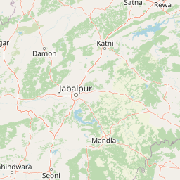
Map view of Ghughua Fossil Park

Use this park location map to pinpoint Ghughua Fossil Park in India, understand its exact geographic position, and read its mapped placement within the surrounding landscape more clearly.

Pigeon | © OpenStreetMap contributors

Location context for Ghughua Fossil Park

Madhya Pradesh
Park atlas

Browse surrounding landscapes and paleobotanical sites for geographic context and conservation insights.

Explore Related National Parks and Protected Areas Near Ghughua Fossil Park in Central India
After exploring Ghughua Fossil Park, delve into nearby national parks and protected areas across central India to trace diverse landscapes and conservation efforts. Compare fossil-rich geological heritage sites with broader regional park geography for enhanced understanding of India's ancient ecosystems and modern protected areas.
National parkUmaria district

Bandhavgarh National Park: A Protected Landscape in India's Umaria District

Explore the geographic boundaries and mapped terrain.

Bandhavgarh National Park is a designated national park offering a unique glimpse into India's protected landscapes. Located within Umaria district, its geographic features and mapped terrain provide valuable context for atlas exploration. Understanding the park's protected area status and its place within the regional geography is key to appreciating its role as a vital natural landscape.

Area
105 km²
Established
1968
IUCN
II
Visitors
176.1K annual
National parkMadhya Pradesh

Kanha National Park: A Madhya Pradesh Protected Landscape for Atlas Exploration

Mapped park boundaries and regional geographic context.

Kanha National Park serves as a vital protected area, offering critical insights into India's natural geography. This entry facilitates detailed atlas-style exploration of its mapped landscape and protected territory within Madhya Pradesh. Understand the park's geographic definition and its role within the broader context of India's conservation lands, providing a foundation for structured geographic discovery.

Area
940 km²
Established
1955
IUCN
II
Visitors
213.8K annual
National parkMadhya Pradesh

Sanjay National Park: Madhya Pradesh Protected Area with Hilly Terrain and Dry Deciduous Forests

Explore the mapped boundaries and landscape context of this national park.

Sanjay National Park, situated in Madhya Pradesh, India, is a substantial protected area recognized for its significant role in conservation. The park features a landscape dominated by hilly terrain and extensive dry deciduous forests, bisected by the Banas River. As a national park and tiger reserve, its mapped geography supports a rich ecosystem and is vital for understanding the protected lands of central India.

Area
1,674.55 km²
Established
1981
IUCN
II
Relief
Highland
National parkMadhya Pradesh

Panna National Park: National Park Atlas and Mapped Protected Landscape

Geographic context and protected boundaries in Madhya Pradesh.

Gain a structured understanding of Panna National Park as a protected national park entity. This detail page focuses on its specific geographic setting within Madhya Pradesh and its mapped landscape features. Explore the park's protected boundaries and regional natural context, ideal for atlas-based discovery and understanding its place in India's conservation geography.

Area
542.67 km²
Established
1981
IUCN
II
Visitors
22.6K annual
Wildlife reserveChhattisgarh

Guru Ghasidas - Tamor Pingla Tiger Reserve: Wildlife Reserve in Chhattisgarh's Mapped Landscapes

Explore protected area geography and regional context.

Guru Ghasidas - Tamor Pingla Tiger Reserve, identified as a wildlife reserve, offers detailed insight into its protected landscape and geographic positioning within Chhattisgarh. Users can explore its mapped boundaries and understand its contribution to the region's natural terrain. This resource focuses on the atlas-style discovery of protected areas, providing a clear picture of the reserve's environmental context and regional significance without delving into visitor logistics.

Area
2,829.38 km²
Established
2024
IUCN
II
Relief
Mixed relief
National parkMadhya Pradesh

Pench National Park: Madhya Pradesh National Park Protected Landscape Overview

Mapped geographic context and protected area boundaries

Pench National Park is a designated national park situated in Madhya Pradesh, India, offering a distinct protected landscape for geographic study. This entry provides detailed insights into its mapped terrain, allowing for an atlas-style exploration of its protected boundaries and its significance within the regional geography. Understand the park's place in the landscape and its value for conservation-focused map exploration.

Area
292.85 km²
Established
1983
IUCN
II
Relief
Upland
National parkMaharashtra

Navegaon National Park: Maharashtra's Designated National Park for Atlas Exploration

Mapped protected area and regional landscape context.

Navegaon National Park is a designated national park offering rich opportunities for geographic discovery. Users can delve into its mapped boundaries and understand its protected landscape character within Maharashtra. This page provides structured data for exploring the park's role as a conservation area and its contribution to the natural geography of the region, ideal for atlas-based research.

Area
1,894.94 km²
Established
1975
IUCN
II
Visitors
50K annual
National parkMadhya Pradesh

Van Vihar National Park: National Park Protected Landscape and Regional Geography

Mapped boundaries within Madhya Pradesh's natural context.

Van Vihar National Park is a designated national park offering a unique perspective on protected landscapes within Madhya Pradesh. This detail entry provides essential geographic context, focusing on the park's mapped boundaries and its role within the region's natural terrain. It serves as a vital point for understanding the distribution and identity of protected areas for atlas exploration.

Area
4.48 km²
Established
1979
IUCN
II
Visitors
250K annual

Common questions about visiting, size, designation, and location context for Ghughua Fossil Park

Ghughua Fossil Park FAQs for park facts, access, geography, and protected area context
Find quick answers about Ghughua Fossil Park, including protected-area facts, park geography, trail and visitor context, and how the park fits into its surrounding country and regional landscape.
MoriAtlas Explorer

Continue Your Protected Areas Search Across the Global Atlas

Deepen your exploration by continuing the structured search for national parks and protected areas worldwide. Utilize the comprehensive filtering capabilities to compare different conservation landscapes and refine your understanding of global park geography. Discover more about the distribution and characteristics of protected natural areas.

Global natural geography