

Mori Atlas logo
National parkPanna National Park

Discover the geographic identity and protected boundaries of this key national park.

Panna National Park: National Park Atlas and Mapped Protected Landscape in Madhya Pradesh

Panna National Park stands as a significant protected national park within the Indian state of Madhya Pradesh. This page provides an authoritative entry point for understanding its precise geographic scope, mapped landscape character, and its role within the broader atlas of protected natural areas. Explore the spatial context and natural terrain that define Panna National Park for comprehensive geographic discovery.

Tiger ReserveBiosphere ReserveDry Deciduous ForestMadhya PradeshBundelkhandKen River

Panna National Park

National park

Park overview

Structured park overview, official facts, and landscape profile for Panna National Park

Panna National Park park facts, protected area profile, and essential visitor context
Review the core facts for Panna National Park, including designation, size, terrain, visitor scale, habitats, and operating context in one park-focused overview.

About Panna National Park

Panna National Park represents one of central India's most significant protected areas, situated in the historically rich Bundelkhand region of Madhya Pradesh. The park's landscape encompasses a mix of dry deciduous forests, open grasslands, and riparian zones along the Ken River, which serves as the lifeblood of the ecosystem. The park's ecological significance stems from its position at a critical biogeographical transition zone, marking the northern boundary of the tropical and subtropical dry broadleaf forest belt and the southern edge of the Upper Gangetic Plains moist deciduous forests. This unique positioning supports a diverse array of habitats and species that are characteristic of both forest types. The surrounding region of northern Madhya Pradesh has experienced significant habitat fragmentation, making Panna and its adjoining forest divisions one of the few remaining large contiguous wildlife habitats in the area. The park's proximity to the famous Khajuraho temples, located just 25 kilometers away, positions it as a significant destination for wildlife tourism combined with cultural exploration of India's architectural heritage.

Quick facts and research context for Panna National Park

Panna National Park spans 542.67 square kilometers in Madhya Pradesh, India, situated in the Bundelkhand region. The park was declared a tiger reserve in 1994 and is governed under Project Tiger by the Government of India and Madhya Pradesh. It forms part of the Ken River drainage basin and represents the northernmost extent of natural teak forests in India. The park was designated a UNESCO Biosphere Reserve in 2020, encompassing nearly 3,000 square kilometers including core, buffer, and transition zones. Panna received the Award of Excellence in 2007 as India's best-maintained national park.

Park context

Deeper park guide and search-rich context for Panna National Park

Panna National Park history, landscape, wildlife, and travel context
Explore Panna National Park through its history, landscape character, ecosystems, wildlife, conservation priorities, cultural context, and seasonal travel timing in a structured park guide built for atlas discovery and search intent.

Why Panna National Park stands out

Panna National Park is best known as a tiger reserve that underwent one of India's most dramatic wildlife recovery stories. The park lost nearly all its tigers to poaching between 2006 and 2009, reaching a point where only two translocated tigresses remained. Through an intensive restoration program involving the relocation of tigers from Bandhavgarh, Kanha, and Pench reserves, the population recovered to approximately 80 tigers. Beyond its tiger significance, the park is noted for its location at the biogeographical junction between tropical dry forests and the Indo-Gangetic plain, its population of over 200 bird species, and its designation as a UNESCO Biosphere Reserve.

Panna National Park history and protected-area timeline

Panna National Park was established in 1981 and officially declared as the twenty-second tiger reserve of India in 1994, becoming the fifth tiger reserve in Madhya Pradesh. The park gained national recognition when it received the Award of Excellence in 2007 from India's Ministry of Tourism as the best-maintained national park in the country. The most significant chapter in the park's history began in 2009 when a devastating poaching crisis resulted in the loss of nearly the entire tiger population that had numbered over 40 individuals just six years earlier. Following this crisis, the Madhya Pradesh government initiated one of India's most ambitious tiger translocation programs. Two female tigers were relocated from Bandhavgarh and Kanha national parks in March 2009, followed by the translocation of a male from Pench Tiger Reserve. Despite the male straying from the park initially, it was successfully tracked and returned, eventually establishing territory and breeding. The first translocated tigress gave birth to four cubs in April 2010, and the second successfully raised four cubs, marking the beginning of the population recovery. In 2020, the park's conservation significance was further elevated with its designation as a UNESCO Biosphere Reserve, expanding protection to encompass nearly 3,000 square kilometers of varied terrain.

Panna National Park landscape and geographic character

The terrain of Panna National Park is characterized by undulating plateaus, deep ravines, and flat expanses that define the distinctive Bundelkhand landscape. The park sits within the Ken River basin, with the 406-kilometer-long river flowing through the protected area for approximately 72 kilometers, creating important riparian corridors and wetland habitats. The landscape features a mix of dense forest cover in the valleys and more open terrain on the plateaus, with scattered rocky outcrops and boulders typical of the region. The forests transition from tropical dry deciduous types in the lower elevations to more moist deciduous characteristics as the terrain rises. The park's position at the transition between distinct forest types creates a mosaic of habitats that supports diverse flora and fauna. The surrounding landscape includes reserved and protected forests from the North and South Panna forest divisions, forming a larger ecological unit that provides connectivity to other habitat patches in the region.

Panna National Park ecosystems, habitats, and plant life

The ecological character of Panna National Park is defined by its position at a critical biogeographical crossroads in central India. The park represents the northernmost extent of natural teak forests in the country and marks the eastern boundary of Kardhai forests dominated by Anogeissus pendula. This transitional setting creates a unique blend of species from both the dry deciduous forest biome and the moist deciduous forest biome of the Indo-Gangetic plain. The Ken River corridor through the park supports riparian vegetation and provides crucial water resources that sustain the ecosystem throughout the year. The park's protected status under Project Tiger and its UNESCO Biosphere Reserve designation in 2020 have strengthened conservation of these ecological communities, which include significant stretches of intact forest habitat that have become increasingly rare in the densely populated agricultural landscape of central India.

Panna National Park wildlife and species highlights

Panna National Park supports a rich community of large mammals, with the Bengal tiger as the flagship species following its remarkable population recovery. The park is home to Indian leopards, which coexist with the tiger population, as well as various ungulates including chital, sambar deer, nilgai, and chinkara. The smaller mammalian fauna includes sloth bears, rusty-spotted cats, and Asian palm civets. The avian diversity is particularly notable, with more than 200 bird species recorded within the park. The bird community includes notable species such as the bar-headed goose, crested honey buzzard, red-headed vulture, plum-headed parakeet, changeable hawk-eagle, and Indian vulture. The Ken River flowing through the park also supports aquatic species and provides important habitat for waterfowl. The recovery of the tiger population from near-complete loss to approximately 80 individuals represents one of the most successful large carnivore restoration stories in India.

Panna National Park conservation status and protection priorities

Panna National Park's conservation significance has been recognized at both national and international levels. The park's designation as a Tiger Reserve under Project Tiger in 1994 brought it under India's flagship conservation program for protecting Bengal tigers and their habitats. The 2007 Award of Excellence from the Ministry of Tourism recognized the park's effective management and maintenance. The most remarkable conservation achievement at Panna has been the successful tiger population recovery following the 2009 poaching crisis, which demonstrated the potential for restoring big cat populations through intensive management and strategic translocation. The 2020 designation of Panna Biosphere Reserve by UNESCO further elevated the conservation framework, creating a zoned protection approach with a 792-square-kilometer core area, a 987-square-kilometer buffer zone, and a 1,219-square-kilometer transition zone encompassing forests, wetlands, villages, and agricultural lands. However, the proposed Ken Betwa River Linking Project poses an emerging conservation challenge, as the construction of the Daudhan Dam could inundate approximately 400 hectares of the tiger reserve.

Panna National Park cultural meaning and human context

Panna National Park is situated in the historically significant Bundelkhand region of Madhya Pradesh, an area rich in cultural heritage and historical monuments. The park lies in close proximity to the world-renowned Khajuraho Group of Monuments, a UNESCO World Heritage Site famous for its medieval Hindu and Jain temples featuring intricate sculptural artwork. The nearest city to the park is Khajuraho, located just 25 kilometers away, making the national park a natural complement to cultural tourism in the region. The Panna district itself has historical significance, with the region having been part of various princely states during the colonial period. The local communities living in the buffer and transition zones of the biosphere reserve maintain traditional agricultural practices and forest-dependent livelihoods that coexist with the protected area's conservation objectives.

Top sights and standout views in Panna National Park

The story of Panna National Park epitomizes both the challenges facing India's wildlife and the potential for successful conservation intervention. The park's tiger population recovery from near extinction to approximately 80 individuals stands as a testament to intensive management and strategic translocations. The UNESCO Biosphere Reserve designation in 2020 created a comprehensive conservation framework protecting nearly 3,000 square kilometers of diverse habitats. The park's position at the northern edge of natural teak forests and its location within the Ken River basin give it significant ecological importance. Combined with proximity to Khajuraho's cultural heritage, Panna offers a unique combination of wildlife conservation and historical tourism in central India.

Best time to visit Panna National Park

The optimal visiting season for Panna National Park runs from October through June, with the winter months from November to February offering the most comfortable conditions for wildlife viewing. During the dry winter months, animals congregate more visibly around water sources, improving sighting opportunities. The summer months of April and May bring intense heat but also increase chances of tiger sightings near remaining waterholes. The monsoon season from July to September brings heavy rainfall that makes the park less accessible for visitors. The cool, dry conditions of winter provide the most pleasant overall experience for visitors combining wildlife exploration with trips to the nearby Khajuraho temples.
Park location guide

Geography guide, regional context, and park location map for Panna National Park

Panna National Park park geography, regions, and map view in India
Understand where Panna National Park sits in India through a broader geographic reading of the surrounding landscape, nearby location context, and its mapped position within the national park landscape.

How Panna National Park fits into India

India is a South Asian country bordered by the Indian Ocean, Arabian Sea, and Bay of Bengal. It shares land borders with Pakistan, China, Nepal, Bhutan, Bangladesh, and Myanmar. The country has a population of over 1.4 billion people and operates as a federal parliamentary republic with its capital in New Delhi.

Wider geography shaping Panna National Park in India

India occupies the Indian subcontinent in South Asia, bordered by the Arabian Sea to the southwest, the Bay of Bengal to the southeast, and the Indian Ocean to the south. It shares land borders with Pakistan to the west, China, Nepal, and Bhutan to the north, and Bangladesh and Myanmar to the east. The territory also includes the Andaman and Nicobar Islands in the Indian Ocean.

Map view of Panna National Park

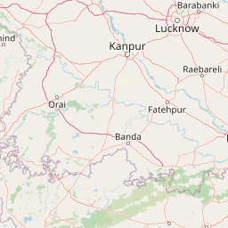
Use this park location map to pinpoint Panna National Park in India, understand its exact geographic position, and read its mapped placement within the surrounding landscape more clearly.

Pigeon | © OpenStreetMap contributors

Location context for Panna National Park

Chhatarpur DistrictMadhya PradeshPanna District
Park atlas

Trace the regional spread of protected areas and compare conservation landscapes surrounding Panna National Park.

Explore Nearby National Parks and Protected Areas: Continuing Your Discovery from Panna National Park
After exploring Panna National Park, continue your discovery of India's conservation efforts by browsing nearby national parks and protected areas in the central region of Madhya Pradesh and the broader Bundelkhand landscape. Compare diverse tiger reserves, forest types, and riparian ecosystems, tracing the geographic spread of significant natural habitats and understanding their regional context.
National parkUmaria district

Bandhavgarh National Park: A Protected Landscape in India's Umaria District

Explore the geographic boundaries and mapped terrain.

Bandhavgarh National Park is a designated national park offering a unique glimpse into India's protected landscapes. Located within Umaria district, its geographic features and mapped terrain provide valuable context for atlas exploration. Understanding the park's protected area status and its place within the regional geography is key to appreciating its role as a vital natural landscape.

Area
105 km²
Established
1968
IUCN
II
Visitors
176.1K annual
National parkMadhya Pradesh

Ghughua Fossil Park National Park: Mapped Geography and Protected Area Context in Madhya Pradesh

Explore the mapped boundaries and regional landscape of Ghughua Fossil Park.

Ghughua Fossil Park stands as a designated national park within the expansive geography of Madhya Pradesh, India. This resource facilitates a detailed exploration of its protected landscape, offering insights into its geographic setting and the significance of its mapped boundaries. Understand the park's place within the regional atlas and its role as a key conservation territory.

Area
0.3 km²
Established
1983
IUCN
II
Access
Access unknown
National parkMadhya Pradesh

Sanjay National Park: Madhya Pradesh Protected Area with Hilly Terrain and Dry Deciduous Forests

Explore the mapped boundaries and landscape context of this national park.

Sanjay National Park, situated in Madhya Pradesh, India, is a substantial protected area recognized for its significant role in conservation. The park features a landscape dominated by hilly terrain and extensive dry deciduous forests, bisected by the Banas River. As a national park and tiger reserve, its mapped geography supports a rich ecosystem and is vital for understanding the protected lands of central India.

Area
1,674.55 km²
Established
1981
IUCN
II
Relief
Highland
National parkMadhya Pradesh

Madhav National Park: National Park Atlas and Protected Landscape Identity

Mapping the geography and protected boundaries of Madhav National Park.

Delve into the detailed geographic profile of Madhav National Park, a vital national park situated in Madhya Pradesh, India. This section offers an atlas-centric perspective, highlighting the park's protected landscape characteristics and its precise location within the regional geography. Uncover its mapped boundaries and understand its role as a key protected area for comprehensive geographic exploration.

Area
354 km²
Established
1956
IUCN
II
Visitors
500 annual
National parkMadhya Pradesh

Kanha National Park: A Madhya Pradesh Protected Landscape for Atlas Exploration

Mapped park boundaries and regional geographic context.

Kanha National Park serves as a vital protected area, offering critical insights into India's natural geography. This entry facilitates detailed atlas-style exploration of its mapped landscape and protected territory within Madhya Pradesh. Understand the park's geographic definition and its role within the broader context of India's conservation lands, providing a foundation for structured geographic discovery.

Area
940 km²
Established
1955
IUCN
II
Visitors
213.8K annual
Wildlife reserveChhattisgarh

Guru Ghasidas - Tamor Pingla Tiger Reserve: Wildlife Reserve in Chhattisgarh's Mapped Landscapes

Explore protected area geography and regional context.

Guru Ghasidas - Tamor Pingla Tiger Reserve, identified as a wildlife reserve, offers detailed insight into its protected landscape and geographic positioning within Chhattisgarh. Users can explore its mapped boundaries and understand its contribution to the region's natural terrain. This resource focuses on the atlas-style discovery of protected areas, providing a clear picture of the reserve's environmental context and regional significance without delving into visitor logistics.

Area
2,829.38 km²
Established
2024
IUCN
II
Relief
Mixed relief
National parkMadhya Pradesh

Kuno National Park: Madhya Pradesh National Park Atlas and Protected Landscape

Explore its diverse dry deciduous forests and savannah terrain.

Kuno National Park is a protected area in Madhya Pradesh, India, renowned for its dry deciduous forest and savannah grassland ecosystems. This national park, bisected by the Kuno River, offers a significant landscape for understanding regional geography and conservation efforts within India. Its varied terrain provides essential habitat and contributes to the broader atlas of protected lands, making it a key destination for geographic discovery.

Area
748.76 km²
Established
2018
IUCN
II
Relief
Lowland
National parkMadhya Pradesh

Van Vihar National Park: National Park Protected Landscape and Regional Geography

Mapped boundaries within Madhya Pradesh's natural context.

Van Vihar National Park is a designated national park offering a unique perspective on protected landscapes within Madhya Pradesh. This detail entry provides essential geographic context, focusing on the park's mapped boundaries and its role within the region's natural terrain. It serves as a vital point for understanding the distribution and identity of protected areas for atlas exploration.

Area
4.48 km²
Established
1979
IUCN
II
Visitors
250K annual

Common questions about visiting, size, designation, and location context for Panna National Park

Panna National Park FAQs for park facts, access, geography, and protected area context
Find quick answers about Panna National Park, including protected-area facts, park geography, trail and visitor context, and how the park fits into its surrounding country and regional landscape.
MoriAtlas Explorer

Continue Your Protected Areas Search Across the Global Atlas

Deepen your exploration by continuing the structured search for national parks and protected areas worldwide. Utilize the comprehensive filtering capabilities to compare different conservation landscapes and refine your understanding of global park geography. Discover more about the distribution and characteristics of protected natural areas.

Global natural geography