
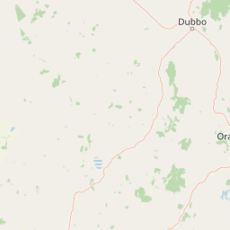
Peaks
Park geography
Detailed analysis of regional terrain, landscape features, and natural water systems
Comprehensive Geographic Profile and Mapped Boundaries of Goobang National Park
Goobang National Park spans 421 square kilometers within New South Wales, Australia, characterized by upland relief and diverse temperate environments. This profile provides a structured examination of the park boundary, mapping prominent natural features including Burrabadine Peak, Gingham Gap, and numerous stream systems across the Great Dividing Range.
Related tags
Woodland conservationNew South Wales national parksEucalyptus forestsProtected wildlife habitatCentral west NSW
Central west NSW's largest remnant forest and woodland protected area
Goobang National Park
Goobang National Park is a significant protected area located in central west New South Wales, approximately 296 kilometers northwest of Sydney. The park encompasses 421 square kilometers of diverse woodland and forest ecosystems, representing the largest remaining tract of such habitat in the central west region of the state. This area serves as a critical refuge where interior and coastal New South Wales flora and fauna species overlap, creating a unique ecological interface. Established as a national park in 1995 after decades as a state forest reserve, Goobang protects a landscape shaped by the ancient Hervey Range, featuring rugged sandstone ridges, volcanic uplands, and timbered valleys that support remarkable biodiversity. The park offers visitors opportunities for bushwalking, wildlife observation, and camping within a landscape that embodies the character of the Australian inland woodland.
- Location
- Australia
- Park type
- National park
- Established
- 1995
- Area
- 421 km²
Location overview
Protected area positioning in New South Wales, Australia
Goobang National Park Geographic Location and Regional Setting
Goobang National Park is situated entirely within the state of New South Wales in Australia. As a terrestrial protected area, it operates under regional jurisdiction without marine or coastal designations.
- Countries
- Australia
- Regions
- New South Wales
- Primary location
- New South Wales
- Geographic setting
- Inland
Boundary and coordinates
Analyzing the geographic extent and estimated 421 square kilometer area
Goobang National Park Boundary Mapping and Spatial Analysis
Interactive mapping of the park boundary provides essential spatial context for the protected corridor. Derived geographic metrics detail the 421 square kilometer area alongside estimated coordinate spans and center points.
- Boundary area
- 424.3 km²
- Boundary perimeter
- 297.8 km
- Northernmost point
- 32.5837° S
- Southernmost point
- 33.207° S
- Easternmost point
- 148.5937° E
- Westernmost point
- 148.274° E
- Geographic centre
- 32.8821° S, 148.4049° E
- North–south span
- 69.1 km
- East–west span
- 29.9 km
Terrain and natural features
Upland terrain classifications and recorded natural features within the park
Goobang National Park Terrain Atlas and Named Natural Features
Upland terrain classifications and mountain park designations define the protected landscape geography. Linked feature cards organize recorded streams, peaks, valleys, and saddles located within the park boundary.
Selected named natural features
Streams
Back Creek
Streams
Pipeclay Creek
Streams
Waterhole Creek
Streams
West Arm
Streams
Oaks Creek
Environmental setting
Temperate climate zones, upland relief, and forest cover classifications across regional terrain.
Goobang National Park Environmental Classifications and Protected Landscape Settings
Stored landscape features, habitat types, and seasonal classifications provide complementary frameworks for examining the physical setting of the protected area. Recorded environmental categories link directly to associated geographic records across the wider conservation network.
- Relief
- Upland
- Climate
- Temperate
- Water
- Minor water
- Forest cover
- Mostly forested
- Seasonality
- Seasonal
Landscape features
Mountains · Hills · Valleys · Forest · Woodland · Rivers
Habitat types
Temperate broadleaf forest · Shrubland · Riverine habitat
Park atlas
Map Goobang's surrounding protected landscapes and compare nearby national parks across New South Wales' unique woodland regions.
Discover Other National Parks Near Goobang National Park, Central West New South Wales
Explore other protected areas and national parks situated within Goobang National Park's regional context, tracing the diverse woodland and forest ecosystems of central west New South Wales. Compare terrain, conservation landscapes, and ecological interfaces as you broaden your discovery from Goobang across geographically adjacent protected areas.
Nature reserveNew South Wales
About 13 km away#1 closest
Southeast

South West Woodland Nature Reserve: Geographic Overview and Protected Forest Boundaries
A fragmented network of conservation precincts in inland New South Wales
Examine the geographic structure of South West Woodland Nature Reserve, a nature reserve defined by its unusual patchwork of twenty-seven isolated woodland islands. Stretching across 400 kilometres, this protected area anchors crucial white cypress pine and eucalypt forest remnants, forming a transition zone between the South Western Slopes and the arid plains of the Murray Darling Depression.
- Area
- 138.4 km²
- Established
- 2011
- IUCN
- Ia
- Relief
- Lowland
National parkNew South Wales
20 km away#2 closest
South
Nangar National Park: Australian National Park Geography and Mapped Boundaries
Explore the protected landscape within New South Wales.
Nangar National Park is a key protected area situated in New South Wales, Australia, offering a valuable point for geographic discovery. This page details its status as a national park, providing insight into its mapped boundaries and its role within the regional landscape. Users can utilize this information to understand the park's specific geographic context and its contribution to the broader atlas of Australia's protected lands.
- Area
- 94 km²
- Established
- 1983
- IUCN
- II
- Relief
- Mountain
Nature reserveNew South Wales
About 41 km away#3 closest
Southeast
Borenore Karst Conservation Reserve: Exploring Limestone Caves and Volcanic Geology
Protected karst landscapes and fossil heritage in New South Wales
Borenore Karst Conservation Reserve offers a dense concentration of limestone features, including the notable Tunnel Cave and expansive fossil-rich sediments. Its geographic identity is defined by the striking contrast between its sedimentary core and the surrounding volcanic terrain of the Central Tablelands, providing a distinct site for investigating regional earth sciences and subterranean ecology.
- Area
- 1.36 km²
- Established
- 1997
- IUCN
- III
- Relief
- Upland
Nature reserveNew South Wales
About 51 km away#4 closest
East
Wellington Caves Nature Reserve: Mapping Limestone Formations and Pleistocene Fossil Sites
Geological atlas of subterranean karst landscapes in New South Wales
The Wellington Caves reserve features a rich subterranean geography shaped by water working through Devonian limestone. Explore the site's mapped network of chambers, including Cathedral Cave and its massive Altar Rock, alongside historic fossil deposits that have shaped Australian paleontology since the 1830s. This protected landscape offers a unique look at karst evolution and subterranean lake systems within the Australian bush.
- Established
- 1884
- Visitors
- 35K annual
- Relief
- Upland
- Scope
- Terrestrial
National parkNew South Wales
53 km away#5 closest
South
Conimbla National Park: Protected Landscape Atlas and Regional Geography
Mapped boundaries and terrain within New South Wales.
Examine the protected landscape of Conimbla National Park, a designated national park situated in New South Wales, Australia. This entry provides focused geographic context, detailing its mapped boundaries and the regional terrain. It serves as a valuable resource for understanding the park's identity within the national atlas and its specific place in the Australian landscape.
- Area
- 84.71 km²
- Established
- 1980
- IUCN
- II
- Relief
- Upland
National parkNew South Wales
84 km away#6 closest
South
Weddin Mountains National Park: National Park Mapping and Geographic Context
Discover mapped protected landscape boundaries in New South Wales.
Weddin Mountains National Park represents a key protected area within New South Wales, Australia, offering a focused lens for geographic exploration. This detail page provides access to the park's specific mapped boundaries and its role as a national park. Understand the surrounding regional geography and the protected landscape's identity through a detailed atlas perspective, ideal for mapping conservation areas.
- Area
- 83.61 km²
- Established
- 1971
- IUCN
- II
- Relief
- Mountain
National parkAustralia
About 100 km away#7 closest
Northeast
Yarrobil National Park: Australia's Protected Landscape for Geographic Discovery
Explore its national park designation and mapped regional context.
Yarrobil National Park stands as a distinct protected landscape within Australia, identified as a national park. Its geographic significance lies in its contribution to the nation's atlas of conservation areas. This page focuses on providing a clear understanding of the park's identity, its environmental setting, and how its mapped boundaries fit into the broader regional geography of Australia, enabling structured exploration for enthusiasts of protected areas and natural landscapes.
- Area
- 13.22 km²
- Established
- 2005
- IUCN
- II
- Relief
- Upland
Natural monumentNew South Wales
About 116 km away#8 closest
Southeast
Abercrombie Caves: Protected Karst Landscape and Geological Monument in New South Wales
Exploration of karst formations and cave morphology
Abercrombie Caves preserve a sophisticated limestone karst system within the Central West region of New South Wales. The reserve is anchored by The Archway, a massive natural bridge sculpted by water erosion, alongside various chambers including King Solomon's Temple and Bushranger's Cave. This natural monument highlights the interplay between rugged range geography, solutional cave development, and the site's enduring historical significance as a former gold-mining and bushranger landscape.
- Area
- 14.34 km²
- Established
- 1997
- IUCN
- III
- Relief
- Upland
MoriAtlas Explorer
Continue Exploring Goobang National Park's Geographic and Landscape Identity
Deepen your understanding of Goobang National Park by exploring its specific mapped boundaries and regional geographic context. This atlas perspective helps to situate the park within its natural landscape and discover its unique features. Continue your exploration to gain a richer appreciation for its protected status and role in the broader geography of New South Wales.
Browse next
Global natural geography
Explore related park routes
Explore MoriAtlas Global ParksBrowse All MoriAtlas ParksGlobal Park Map DiscoveryMoriAtlas: Browse All CountriesBrowse All MoriAtlas ContinentsNational Park Environment AtlasGrand Canyon National Park AtlasYellowstone National Park AtlasYosemite National Park Atlas and GeographySerengeti National Park AtlasGalápagos National Park Protected LandscapeBanff National Park Geography and AtlasKruger National Park Atlas EntryUluṟu-Kata Tjuṯa National Park AtlasExplore Uluru-Kata Tjuta National Park GeographyPlitvice Lakes National Park AtlasFiordland National Park Protected LandscapeGreat Smoky Mountains National Park AtlasAfghanistan National Parks and Protected AreasAlbania National Parks and Protected AreasAlgeria National Parks and Protected AreasAmerican Samoa National Parks and Protected AreasAndorra National Parks and Protected AreasAngola National Parks and Protected AreasAntarctica National Parks and Protected AreasAntigua and Barbuda Park List