Mori Atlas logo
Marine protected areaGray's Reef National Marine Sanctuary

Understanding the submerged sandstone topography and marine ecosystems off the Atlantic coast

Gray's Reef National Marine Sanctuary: Mapping the Protected Live-Bottom Reefs of Georgia

Gray's Reef National Marine Sanctuary encompasses a distinct three-dimensional underwater landscape on the continental shelf, located roughly 19 miles east of Sapelo Island, Georgia. This protected marine area features a mosaic of rocky sandstone ledges and expansive sandy flats, providing a rare habitat structure within the western Atlantic. The sanctuary serves as a key reference for studying complex reef communities, where dense invertebrate growth covers the rock to create a thriving and ecologically vital submerged environment.

marine sanctuarylive-bottom reefoffshore reefAtlantic coastcontinental shelfsandstone reef

Gray's Reef National Marine Sanctuary

Marine protected area

Park overview

Structured park overview, official facts, and landscape profile for Gray's Reef National Marine Sanctuary

Gray's Reef National Marine Sanctuary park facts, protected area profile, and essential visitor context

Review the core facts for Gray's Reef National Marine Sanctuary, including designation, size, terrain, visitor scale, habitats, and operating context in one park-focused overview.

About Gray's Reef National Marine Sanctuary

Gray's Reef National Marine Sanctuary is a federally protected marine environment situated in the Atlantic Ocean about 19 miles southeast of Sapelo Island, Georgia. The sanctuary lies entirely underwater, with its reef structure resting beneath 60 to 70 feet of seawater on the open continental shelf. Though modest in size compared to vast open-ocean preserves, it concentrates an unusual amount of biological complexity within its 22 square miles because of the rocky relief that breaks up what is otherwise a sandy seafloor.

At the heart of the sanctuary's character is its geology. The reef is built on ancient sandstone outcrops that rise above the surrounding bottom in ledges and ridges. These rocky elevations create vertical structure in an otherwise relatively flat shelf environment. Over this rock grows a dense community of invertebrates such as sponges, soft corals, sea whips, and tunicates, along with algae and many species of fish. Because living organisms often coat the rock surface entirely, the habitat is referred to as a live bottom, a term used throughout the southeastern U.S. to describe reefs dominated by attached invertebrates rather than stony coral.

Gray's Reef is administered by the National Oceanic and Atmospheric Administration as part of the U.S. National Marine Sanctuary System, a network of protected marine areas around the country. The site is used both for conservation and for research, with partnerships involving the University of Georgia and other institutions. Studies at Gray's Reef have examined invertebrate and vertebrate communities, the reef's geology, the processes of seafloor erosion, and, remarkably, the prehistoric human presence along what was once a dry-land coastline now submerged beneath the Atlantic.

Quick facts and research context for Gray's Reef National Marine Sanctuary

Gray's Reef National Marine Sanctuary is a federally designated marine protected area off the Georgia coast in the southeastern United States. It was established on January 16, 1981, by NOAA, and covers about 22 square miles (57 square kilometers) of Atlantic seafloor roughly 19 miles offshore. The reef lies 60 to 70 feet beneath the surface and consists of exposed sandstone ledges interspersed with sandy bottom, forming the characteristic live-bottom habitat that gives the site its name. It is one of the largest near-shore live-bottom reefs in the region and serves as both an important research site and a component of the U.S. National Marine Sanctuary System.

Protection and recognition

Documented marine protection scope, 1981 establishment, and international recognition facts

Gray's Reef National Marine Sanctuary Protection Status and Designation History

Marine conservation records for Gray's Reef National Marine Sanctuary outline the documented 1981 designation history and protective management scope. Structured protection facts provide clear insight into the governance and official administrative framework governing the marine area.

Protection details

Protection scope
Marine
Designated year
1981
Transboundary protection
No
Park context

Deeper park guide and search-rich context for Gray's Reef National Marine Sanctuary

Gray's Reef National Marine Sanctuary history, landscape, wildlife, and travel context

Explore Gray's Reef National Marine Sanctuary through its history, landscape character, ecosystems, wildlife, conservation priorities, cultural context, and seasonal travel timing in a structured park guide built for atlas discovery and search intent.

Why Gray's Reef National Marine Sanctuary stands out

Gray's Reef is best known for being one of the largest near-shore live-bottom reefs anywhere in the southeastern United States. The sanctuary's submerged sandstone ledges rise two to three meters above the surrounding seafloor and provide an extraordinarily complex structure of cracks, crevices, and overhangs that act as habitat for sponges, soft corals, and a rich variety of fish. This dense biological covering is what gives the reef its distinctive live-bottom character, in which living organisms can completely obscure the underlying rock. The combination of rocky reef, sand flats, and offshore position makes the sanctuary a key reference site for understanding continental shelf habitat along the U.S. South Atlantic coast.
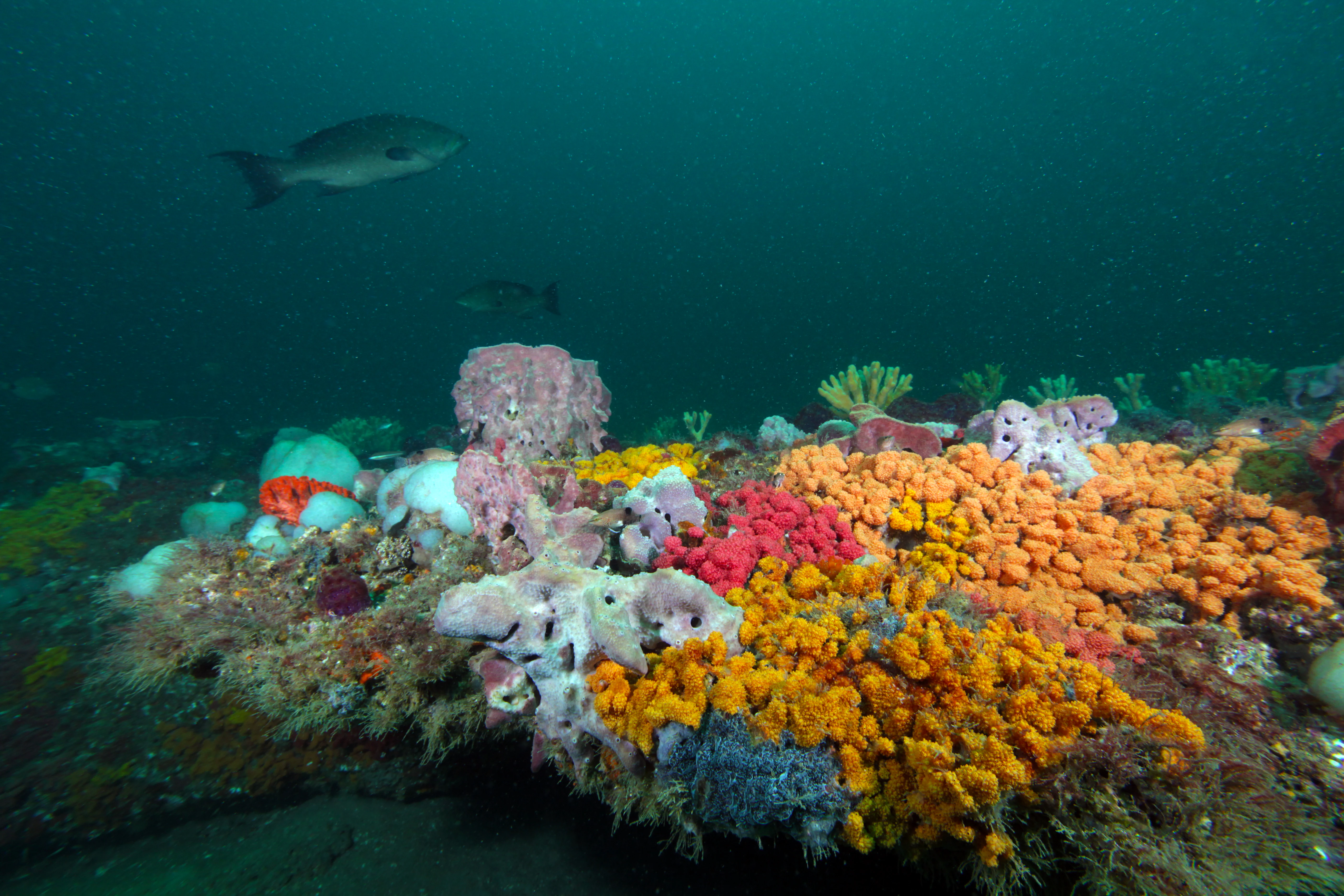
An underwater wide shot of a scamp grouper swimming over a rocky reef densely covered in bright orange, pink, and yellow sponges.
A scamp grouper swims above the colorful, sponge-covered live-bottom reef in Gray's Reef National Marine Sanctuary.

Gray's Reef National Marine Sanctuary history and protected-area timeline

Gray's Reef was designated as a National Marine Sanctuary on January 16, 1981, placing the site under the long-term protection of the National Oceanic and Atmospheric Administration. Its establishment recognized both the ecological significance of the living reef community and the value of the area for marine research off the southeastern United States.

Although the sanctuary itself is a relatively recent designation, the seafloor it protects has a far older story. During the last ice age, sea levels along the U.S. coast were more than 200 feet lower than they are today, and what is now Gray's Reef lay above water as part of the North American mainland. The shoreline of the Atlantic and the Gulf of Mexico once sat many miles further out to sea, leaving the continental shelf exposed. As the climate warmed at the end of the Pleistocene, rising seas gradually submerged this landscape.

Archaeological and paleontological work has shown that humans occupied the region during this transition. Evidence from the reef and its surroundings suggests human presence in the area dating back at least 13,250 years, including materials associated with Clovis and other Paleoindian cultures from more than 10,000 years ago. A 2003 University of Georgia research project documented fossils and artifacts from the reef, highlighting the site as both a natural and a cultural archive of a lost coastal landscape.

Gray's Reef National Marine Sanctuary landscape and geographic character

The landscape of Gray's Reef is an underwater one, set on the broad continental shelf of the western Atlantic Ocean off the coast of Georgia. Rather than forests, peaks, or coastlines, the sanctuary's defining terrain is a mosaic of rocky reef structure and sandy flats lying roughly 60 to 70 feet beneath the ocean surface.

The reef's foundation is sandstone, formed in an ancient environment and now exposed across the seafloor. Where the sandstone has resisted erosion, it forms ledges and ridges that rise two to three meters above the surrounding bottom. Where softer material has worn away, sandy flat areas fill the spaces between outcrops. This alternation of rock and sand creates a varied bottom topography unusually rich for an offshore, mid-shelf setting.

The three-dimensional quality of the reef is central to its identity. The sandstone ledges provide vertical surfaces, cracks, ledges, and overhangs that give marine organisms places to attach, shelter, and feed. The result is a rugged, textured underwater topography that contrasts sharply with the smoother sandy seafloor that dominates much of the surrounding shelf.

Gray's Reef National Marine Sanctuary ecosystems, habitats, and plant life

Gray's Reef hosts a layered marine ecosystem built on its rocky sandstone base. The hard substrate supports a community of sessile invertebrates and algae, while the sandy areas between outcrops host their own characteristic infauna and mobile species. This combination of hard bottom and soft bottom gives the sanctuary unusually high habitat diversity for a location of its size.

The reef's biological structure is dominated by sponges, soft corals, sea whips, tunicates, and various algae that encrust the exposed rock. These organisms form the foundation of the live-bottom community, providing shelter and feeding grounds for fish and invertebrates. Because many of these species grow over and across one another, the living layer can be thick enough to fully conceal the underlying sandstone.

Environmental conditions at Gray's Reef are shaped by its position on the South Atlantic continental shelf. The sanctuary experiences the influence of Georgia's coastal climate, including warm temperate waters, seasonal shifts in temperature, and relatively turbid conditions associated with runoff and shelf dynamics. These conditions contribute to a productive, dynamic marine habitat that supports species characteristic of both the subtropical and warm-temperate zones of the U.S. Atlantic coast.

Gray's Reef National Marine Sanctuary wildlife and species highlights

Gray's Reef is recognized for the abundance and diversity of life concentrated on its relatively small footprint. The reef supports a wide range of marine invertebrates, including sponges, soft corals, sea whips, tunicates, crabs, shrimp, and sea stars, all of which thrive on and around the exposed sandstone ledges. These invertebrates in turn provide food and habitat for more than sixty species of fish recorded in the sanctuary.

Common fish residents include groupers, snappers, grunts, porgies, and other reef-associated species that use the ledges for shelter and hunting grounds. The vertical relief of the rock provides ambush points and hiding places, while the sandy flats offer feeding areas for species that forage over open bottom. Larger predators and seasonal visitors also move through the sanctuary, contributing to a food web that extends well beyond the reef itself.

Researchers have used Gray's Reef as a long-term study site for understanding how these animal communities change over time, how they interact with the physical reef structure, and how offshore reef habitats fit into the broader ecology of the South Atlantic Bight. Its wildlife value is therefore both intrinsic, in the diversity of species present, and scientific, in serving as a reference site for live-bottom ecology along the southeastern U.S. coast.

Gray's Reef National Marine Sanctuary conservation status and protection priorities

Gray's Reef holds conservation significance as one of the largest near-shore live-bottom reefs in the southeastern United States and as a rare example of an offshore hard-bottom habitat protected at the federal level. By safeguarding its sandstone reef structure and associated biological communities, the sanctuary helps preserve a type of seafloor that has been altered or lost in many other parts of the South Atlantic shelf.

As a National Marine Sanctuary, the site is managed under NOAA's National Marine Sanctuary System, which applies habitat and species management measures similar in spirit to IUCN Category IV protected areas. The designation imposes restrictions on activities that could harm the reef, creating a buffer against certain forms of disturbance and helping maintain ecosystem integrity.

Beyond direct protection, Gray's Reef contributes to conservation science through long-term monitoring and research partnerships, particularly with the University of Georgia. These efforts track changes in reef communities, document biodiversity, and provide information that can inform broader marine conservation and management decisions along the U.S. Atlantic coast. In this sense the sanctuary functions both as a protected habitat and as an outdoor laboratory for understanding live-bottom ecosystems.

Gray's Reef National Marine Sanctuary cultural meaning and human context

Although Gray's Reef is an offshore site beneath open ocean today, its cultural dimension lies in the deep history of the landscape it now covers. During the Late Pleistocene, when sea levels were far lower, the area where the reef sits was part of the dry land of North America, and its former coastline extended many miles further out to sea. That submerged land was once inhabited and used by early peoples.

Research at the reef has produced evidence of human occupation of the region extending back more than 13,000 years, including artifacts associated with Clovis culture and other Paleoindian groups from over 10,000 years ago. The 2003 University of Georgia study brought together paleontological and archaeological findings, treating the reef not just as a marine site but as a record of a vanished coastal landscape.

This long human history gives the sanctuary an unusual layered identity: a modern marine protected area whose seafloor also preserves traces of some of the earliest known inhabitants of the southeastern United States. The cultural significance of Gray's Reef is therefore closely tied to its geological and environmental history rather than to recent human activity.

Top sights and standout views in Gray's Reef National Marine Sanctuary

Gray's Reef stands out for the density and complexity of its underwater communities, the unusual prominence of its rocky reef structure on an otherwise sandy shelf, and the opportunity it provides to study a relatively undisturbed near-shore reef environment. Its combination of ecological richness, scientific value, and deep prehistoric history makes it a distinctive member of the U.S. National Marine Sanctuary System.

The sanctuary's most recognizable quality is its live-bottom character, in which sponges, soft corals, and other invertebrates coat the sandstone ledges so thoroughly that the rock beneath can disappear from view. This visual and ecological richness, concentrated in a manageable area not far from shore, defines the park's strongest points of interest for researchers, divers, and anyone interested in southeastern U.S. marine life.

Best time to visit Gray's Reef National Marine Sanctuary

Because Gray's Reef lies entirely underwater, seasonal conditions that shape a visit are largely about water temperature, visibility, weather, and ocean conditions rather than terrestrial seasons. Off the Georgia coast, water temperatures are warmest and conditions tend to be most favorable for offshore boating and diving during late spring through early fall, when calmer seas are more common and visibility over the reef may improve.

Winter months bring cooler water temperatures and more variable weather, including stronger frontal systems that can make offshore trips less predictable. Spring and autumn are often transitional, with shifting water conditions and the possibility of both calm periods and storm-driven seas. Anyone planning a visit should think of timing in terms of safe offshore conditions and water temperature comfort, both of which can vary year to year.

Monthly climate preview

Long-term representative monthly temperature and precipitation patterns across the marine sanctuary coordinate.

Gray's Reef National Marine Sanctuary Climate Normals and Temperature Rhythms

Representative coordinate measurements reveal how monthly average temperatures and precipitation shift across the marine sanctuary throughout the year. Examining the full twelve-month profile provides complete historical averages for researchers analyzing long-term climate normals.
Annual mean21 °C
15 °C28 °C
Jan15°
Feb15°
Mar17°
Apr20°
May23°
Jun26°
Jul28°
Aug28°
Sep27°
Oct24°
Nov19°
Dec16°
Warmest month
August

27.8 °C

Coolest month
January

14.6 °C

Wettest month
August

5.1 mm/day

Driest month
November

2 mm/day

Park location guide

Geography guide, regional context, and park location map for Gray's Reef National Marine Sanctuary

Gray's Reef National Marine Sanctuary park geography, regions, and map view in United States of America

Understand where Gray's Reef National Marine Sanctuary sits in United States of America through a broader geographic reading of the surrounding landscape, nearby location context, and its mapped position within the national park landscape.

How Gray's Reef National Marine Sanctuary fits into United States of America

The United States of America is a federal presidential republic and one of the world's largest countries by area and population. It consists of 50 states across a vast territory spanning multiple time zones, with its capital in Washington, D.C. and largest city in New York City. The nation has a diverse economy, influential political system, and significant cultural and military presence globally.

Wider geography shaping Gray's Reef National Marine Sanctuary in United States of America

The United States occupies a vast territory in North America, bordered by Canada to the north and Mexico to the south. The 48 contiguous states stretch from the Atlantic to the Pacific Ocean, while Alaska occupies the northwestern region and Hawaii is an archipelago in the Pacific. The country encompasses diverse terrain including the Rocky Mountains, Appalachian Mountains, Great Plains, and extensive river systems.

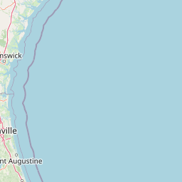
Map view of Gray's Reef National Marine Sanctuary

Use this park location map to pinpoint Gray's Reef National Marine Sanctuary in United States of America, understand its exact geographic position, and read its mapped placement within the surrounding landscape more clearly.

Pigeon | © OpenStreetMap contributors

Location context for Gray's Reef National Marine Sanctuary

Georgia

Visual exploration of sandstone ledges, live bottom habitats, and offshore marine terrain

Gray's Reef National Marine Sanctuary Photos and Underwater Scenery

Visual records reveal the complex underwater topography and dense marine habitats defining Gray's Reef National Marine Sanctuary. Detailed photography documents the sandstone ledges and biological communities characterizing this protected coastal shelf environment.

An underwater wide shot of a scamp grouper swimming over a rocky reef densely covered in bright orange, pink, and yellow sponges.

Park atlas

Compare surrounding marine reserves and coastal habitats across the continental shelf

Explore Parks Near Gray's Reef National Marine Sanctuary and Related Protected Areas

Browse other protected areas and marine habitats linked to the regional geography of Gray's Reef National Marine Sanctuary. Continuing into nearby conservation landscapes allows deeper comparison of Atlantic coastal ecosystems and offshore natural features.
A soft watercolor painting of a coastal scene with sandy dunes, pine trees, and palmetto bushes against a pale, warm-toned sky.
Protected areaGeorgia
63 km away#1 closest

Southwest

Cumberland Island National Seashore: Protected Barrier Island Geography and Mapping

A wild coastal landscape on the southeastern Georgia shoreline

Cumberland Island National Seashore stands as a significant protected area on the Atlantic coast, defined by its lack of paved roads and vehicle-free status. The geography spans a complex array of habitats, including maritime forests, tidal creeks, and salt marshes, anchored by historic estates. This protected landscape represents an essential case study in coastal barrier island ecology and preserved historic environments.

Area
147.368 km²
Established
1972
IUCN
II
Visitors
60.3K annual
A minimalist watercolor painting showing a vast coastal marshland with meandering tidal creeks and green islands under a bright, open sky.
Nature reserveSouth Carolina
About 124 km away#2 closest

North

Ashepoo Combahee Edisto Basin National Estuarine Research Reserve: Mapped Protected Area

Coastal river convergence and tidal marsh geography

Spanning 140,000 acres of the South Carolina Lowcountry, this estuarine reserve protects a unique intersection of blackwater river systems and Atlantic coastal marshlands. The area provides a vital habitat for various species, where historic plantation lands, cypress swamps, and productive salt marshes form one of the largest undeveloped estuarine complexes on the United States eastern seaboard.

Area
570 km²
Relief
Lowland
Climate
Subtropical
Access
Access unknown
Nature reserveFlorida
About 158 km away#3 closest

South

Guana Tolomato Matanzas National Estuarine Research Reserve: Florida Nature Reserve Atlas

Protected estuarine geography and coastal river convergence

Discover the geographic complexity of this research-driven protected area, where freshwater and saltwater environments converge along the Florida coastline. The reserve features an intricate network of tidal creeks, pine flatwoods, and coastal dunes, providing a unique look into the regional ecology of the Carolinian marine bioregion and its significant role in maritime conservation science.

Area
296.46 km²
Established
1999
IUCN
IV
Relief
Lowland
A watercolor painting showing a soft, stylized landscape with rolling green hills, a small river or stream, and a hazy sky at sunrise or sunset.
Protected landscapeFlorida
163 km away#4 closest

Southwest

Osceola National Forest: Mapping the Protected Landscapes and Geography of Northeast Florida

Pine flatwoods, cypress swamps, and historic wilderness terrain

Osceola National Forest serves as a protected landscape in northeast Florida, defined by its extensive pine flatwoods and cypress-hardwood swamp mosaics. The forest provides vital habitat for wildlife like the Florida black bear and red-cockaded woodpecker, while preserving significant historical narratives. Its geography, marked by low elevations and slow-moving water, creates an expansive natural environment for ecological observation and regional exploration.

Area
772.67 km²
Established
1931
Relief
Lowland
Climate
Subtropical
A horizontal watercolor painting depicting a soft-toned, light-filled forest landscape with a calm body of water in the foreground and rolling treed hills in the background.
Protected landscapeFlorida
222 km away#5 closest

South

Ocala National Forest: A Comprehensive Look at Florida's Largest National Forest Landscape

Protected scrub ecosystems and hydric river networks

Explore the geographic expanse of Ocala National Forest, the oldest national forest east of the Mississippi. This protected area features the vast Big Scrub, a unique sand pine ecosystem that anchors a diverse terrain of longleaf pine, blackwater rivers, and crystal-clear springs across multiple Florida counties.

Area
1,741.96 km²
Established
1908
Relief
Lowland
Climate
Subtropical
A pale watercolor landscape painting featuring silhouetted dead trees against a soft, light-colored prairie background.
Wildlife reserveMarion County
244 km away#6 closest

South

Juniper Prairie Wilderness: Wildlife Reserve Geography and Mapped Protected Landscapes

Central Florida ecological preserve in Marion County

Covering over 13,000 acres, Juniper Prairie Wilderness preserves a transition of ecosystems from dry pine scrub to wet sawgrass flats. This wildlife reserve in Marion County provides essential protection for the Juniper River drainage basin and its first-magnitude springs, offering a dense study of central Florida natural history and terrain.

Area
54 km²
Established
1984
IUCN
Ib
Relief
Lowland
National parkSouth Carolina
258 km away#7 closest

North

Congaree National Park: A Protected National Park in South Carolina's Geographic Landscape

Explore mapped boundaries and regional park geography.

Congaree National Park represents a vital protected national park entity within South Carolina, offering rich opportunities for geographic discovery and landscape exploration. Its designation as a National Park underscores its importance in mapping protected areas and understanding regional terrain. This entry provides essential context for exploring the park's specific geographic features and its position within the broader atlas of conservation landscapes.

Area
108.021 km²
Established
2003
IUCN
Ib
Visitors
287.8K annual
Protected landscapeSouth Carolina
261 km away#8 closest

North

Sumter National Forest: Mapping Protected Landscapes and Terrain in South Carolina

Bridging Piedmont forests and Appalachian mountain foothills

Sumter National Forest offers a study in geographic contrast, as its three districts span the transition from South Carolina Piedmont ridges to the rugged spurs of the Blue Ridge Mountains. This protected area features the Chattooga Wild and Scenic River corridor, expansive hardwood-conifer mosaics, and complex mountain watersheds. The forest provides a window into regional land restoration, where reclaimed farmland and mountain ridges now form a continuous network of protected natural terrain.

Area
1,500.98 km²
Established
1936
Relief
Mixed relief
Climate
Temperate

Common questions about visiting, size, designation, and location context for Gray's Reef National Marine Sanctuary

Gray's Reef National Marine Sanctuary FAQs for park facts, access, geography, and protected area context

Find quick answers about Gray's Reef National Marine Sanctuary, including protected-area facts, park geography, trail and visitor context, and how the park fits into its surrounding country and regional landscape.
MoriAtlas Explorer

Continue Your Protected Areas Search Across the Global Atlas

Deepen your exploration by continuing the structured search for national parks and protected areas worldwide. Utilize the comprehensive filtering capabilities to compare different conservation landscapes and refine your understanding of global park geography. Discover more about the distribution and characteristics of protected natural areas.

Global natural geography