

Mori Atlas logo
Wildlife reserveGreat Sandhills National Wildlife Area

Examining the geographic boundaries and ecological features of this significant Canadian prairie wildlife reserve.

Great Sandhills National Wildlife Area: A Protected Saskatchewan Dune and Grassland Landscape

The Great Sandhills National Wildlife Area protects a distinct mosaic of stabilized sand dunes, native mixed grassland, and alkaline wetland basins in southwestern Saskatchewan. This wildlife reserve serves as a critical conservation site within the Canadian Prairies, representing a focused approach to safeguarding threatened mixed-grass ecosystems. The landscape features rolling terrain where wind-shaped sand formations meet open saline flats, providing a unique look into the natural diversity of the Great Sandhills region.

prairienative grasslandsand dunesalkaline wetlandsgrassland birdsSaskatchewan

Great Sandhills National Wildlife Area

Wildlife reserve

Park overview

Structured park overview, official facts, and landscape profile for Great Sandhills National Wildlife Area

Great Sandhills National Wildlife Area park facts, protected area profile, and essential visitor context

Review the core facts for Great Sandhills National Wildlife Area, including designation, size, terrain, visitor scale, habitats, and operating context in one park-focused overview.

About Great Sandhills National Wildlife Area

The Great Sandhills National Wildlife Area is a federally protected conservation site in southwest Saskatchewan, near the Alberta border. It represents a relatively new but strategically designed addition to Canada's National Wildlife Area system, created to preserve a representative slice of the Great Sandhills region while consolidating protection on lands of highest ecological value.

The site sits within the broader Great Sandhills, a roughly 1,500 square kilometer dune field that is one of the most distinctive landforms in the Canadian Prairies. While only a small fraction of this dune landscape falls within the wildlife area, the site's inclusion of stabilized dunes, alkaline wetlands, and adjacent native mixed prairie captures the defining ecological mosaic of the region. Native prairie in this area is widely recognized as one of the most threatened ecosystems on the planet, having been reduced to a small fraction of its original extent by cultivation and land conversion.

The Great Sandhills National Wildlife Area was established through a process of reorganizing the older Prairie National Wildlife Area, a much larger but more diffuse federal reserve that once covered 26 separate parcels across southern Saskatchewan. A 2020 scientific review concluded that only seven of those parcels met modern criteria for national wildlife area designation, leading to the decision to replace the older reserve with five smaller, more focused wildlife areas and to remove protection from the remaining 19 parcels. Great Sandhills NWA corresponds to former units 20 and 21 of the old Prairie National Wildlife Area and was formally created on the same day that the earlier reserve was officially abolished.

Because the area is recent and small, much of its significance lies in its role within the larger Great Sandhills ecosystem rather than in visitor infrastructure or scale. It provides a protected foothold for grassland-dependent wildlife in a working landscape where cultivation and grazing continue to dominate, and it helps ensure that portions of native dune and prairie habitat remain intact for future conservation, scientific study, and the continued presence of species that depend on these rare habitats.

Quick facts and research context for Great Sandhills National Wildlife Area

The Great Sandhills National Wildlife Area is a federal Canadian protected area in southwest Saskatchewan, administered by the Canadian Wildlife Service. It lies in the Rural Municipality of Happyland No. 231, about 35 kilometers southeast of Leader, and was formally designated on March 12, 2025, alongside the abolition of the older Prairie National Wildlife Area. The area covers roughly 475 hectares of land that includes native mixed prairie, cultivated prairie, alkaline wetlands, and stabilized sand dunes, making it a compact but ecologically varied addition to Canada's network of national wildlife areas.

Protection and recognition

Documented terrestrial protection metrics and conservation scope records

Great Sandhills National Wildlife Area Protection Status and Regional Scope

Great Sandhills National Wildlife Area maintains a documented terrestrial protection scope within the national conservation inventory. Systematic records aggregate available designation data, management frameworks, and official recognition sources for this protected landscape.

Protection details

Protection scope
Terrestrial
Park context

Deeper park guide and search-rich context for Great Sandhills National Wildlife Area

Great Sandhills National Wildlife Area history, landscape, wildlife, and travel context

Explore Great Sandhills National Wildlife Area through its history, landscape character, ecosystems, wildlife, conservation priorities, cultural context, and seasonal travel timing in a structured park guide built for atlas discovery and search intent.

Why Great Sandhills National Wildlife Area stands out

Great Sandhills National Wildlife Area is best known for protecting a piece of the Great Sandhills dune landscape, one of the most striking dune systems in southern Saskatchewan. The wildlife area combines stabilized dunes with adjacent native mixed grassland and saline or alkaline wetland basins, creating a mosaic of habitats important for prairie biodiversity. The area is also recognized as part of a renewed federal effort to focus conservation on the most ecologically valuable parcels of Canada's prairie landscape. By consolidating protection around two former units of the old Prairie National Wildlife Area, Great Sandhills NWA represents a more targeted approach to safeguarding native prairie at a moment when this ecosystem is among the most endangered in the world.

Great Sandhills National Wildlife Area history and protected-area timeline

The history of the Great Sandhills National Wildlife Area is closely tied to the evolution of federal prairie conservation in Saskatchewan. In 1978, the Canadian government established the Prairie National Wildlife Area, a dispersed reserve made up of 26 separate units spread across the southern part of the province. For decades, this patchwork reserve represented the main federal effort to conserve native prairie habitat in the region, including portions of the Great Sandhills.

Over time, the effectiveness of this approach was reassessed. In October 2020, Environment and Climate Change Canada completed a rigorous scientific review of the Prairie National Wildlife Area using criteria established in 2005 for the creation of national wildlife areas. The review concluded that only seven of the original 26 units still met the standards required for modern national wildlife area status. The remaining 19 units were judged no longer suitable for that level of protection.

As a result, the government decided to dissolve the Prairie National Wildlife Area and replace it with five smaller, more focused national wildlife areas, each drawn from the most ecologically valuable remaining units. One of these new designations, the Great Sandhills National Wildlife Area, was formed from former units 20 and 21 of the older reserve. On March 12, 2025, the Prairie National Wildlife Area was officially abolished, and Great Sandhills NWA was simultaneously established, marking the end of one era of Canadian prairie conservation and the beginning of a more targeted approach centered on native grassland and dune ecosystems.

Great Sandhills National Wildlife Area landscape and geographic character

The landscape of the Great Sandhills National Wildlife Area reflects the dual character of southwest Saskatchewan's Great Sandhills region. Part of the area is composed of stabilized sand dunes, soft undulating landforms that support specialized dryland vegetation and give the region its distinctive rolling, sandy character. These dunes are remnants of a larger active dune field and now sit partly fixed by grass cover, although wind can still reshape the surface in exposed places.

Interspersed with the dunes are patches of native mixed grassland, cultivated prairie, and shallow alkaline or saline wetlands. The alkaline wetlands are a particularly important landscape element, forming low-lying basins where seasonal moisture collects and salts accumulate, producing a distinctive habitat that contrasts sharply with the surrounding drier grassland. The combination of dunes, flat prairie, and wetland basins gives the area a varied microtopography within a relatively small footprint, with sandy ridges, grassy flats, and seasonal wet hollows all present within the protected boundary.

The terrain is gently rolling rather than mountainous or rugged, and the area lacks dramatic elevation changes. Instead, its landscape identity comes from texture, from the interplay of sand, soil, grasses, and the occasional sheen of water on an alkaline flat, all under the wide open sky characteristic of the Canadian Prairies.

Great Sandhills National Wildlife Area ecosystems, habitats, and plant life

Ecologically, the Great Sandhills National Wildlife Area is defined by its combination of mixed grass prairie, sandy dune habitat, and saline or alkaline wetland basins. Native mixed prairie, made up of grasses such as needle-and-thread grass, western wheatgrass, and blue grama, is the dominant ecological type and is considered globally threatened because of widespread conversion to cropland across the Great Plains.

The dune component adds a specialized dry, sandy plant community, with species such as sand grass and other drought-tolerant plants adapted to shifting substrates and low moisture. Alkaline wetlands introduce a third ecological dimension, supporting halophytic vegetation and seasonal wet conditions that contrast with the surrounding dryland. Together, these habitats form a compact ecological mosaic that captures a meaningful sample of the natural diversity of the Great Sandhills.

Because the area was protected through careful scientific review rather than broad land acquisition, the ecological value of each included parcel is relatively high. The mixture of cultivated and native prairie also reflects the working agricultural context of southern Saskatchewan, and the native portions are especially important as refuges for the plants and animals that depend on intact mixed grassland.

Great Sandhills National Wildlife Area wildlife and species highlights

Wildlife at the Great Sandhills National Wildlife Area is typical of southwest Saskatchewan's mixed grass prairie and dune landscape. Grassland songbirds are among the most visible and ecologically important groups in the area. Species recorded here include chestnut-collared longspur, Baird's sparrow, grasshopper sparrow, vesper sparrow, savannah sparrow, western meadowlark, and McCown's longspur, all of which rely heavily on native prairie and are of conservation concern across much of their range.

Mammals in the area reflect the broader prairie fauna of the region. Pronghorn, mule deer, white-tailed deer, coyote, American badger, and Richardson's ground squirrel are all present, with Richardson's ground squirrel in particular often visible in sandy and grassy terrain. These mammals use the area's mix of dune, grassland, and wetland habitats for foraging and shelter.

Herpetofauna documented at the site includes plains garter snake, bullsnake, and the Great Plains toad. Reptile and amphibian presence is significant in this kind of mixed habitat mosaic, since alkaline wetlands and sandy exposures provide breeding habitat, basking sites, and moisture sources that are otherwise scarce in the dry surrounding landscape. The combination of breeding birds, ground-nesting songbirds, large and small mammals, and reptile and amphibian life makes the area an ecologically active protected landscape despite its modest size.

Great Sandhills National Wildlife Area conservation status and protection priorities

From a conservation perspective, the Great Sandhills National Wildlife Area is significant because it protects a portion of native mixed prairie, one of the most endangered ecosystems in the world. Across the Great Plains, including the Canadian Prairies, native grassland has been reduced to a small fraction of its historic extent due to conversion for agriculture, and remaining fragments are increasingly important for the survival of grassland-dependent species.

The area's designation is more meaningful than its small size might suggest because it was created through a strict scientific selection process. Former units of the Prairie National Wildlife Area were evaluated using criteria that emphasized ecological representativeness, habitat quality, and long-term viability. Only sites meeting these standards were retained and reorganized into the newer, smaller wildlife areas such as Great Sandhills NWA.

By protecting native grass cover, alkaline wetlands, and stabilized dunes together, the area contributes to broader landscape-level conservation in the Great Sandhills, where habitat fragmentation is a continuing challenge. Its existence also reflects a national shift toward more strategic, smaller scale, higher value protected areas rather than large dispersed reserves whose effectiveness can be diluted across many separate parcels.

Great Sandhills National Wildlife Area cultural meaning and human context

The Great Sandhills National Wildlife Area sits in a part of Saskatchewan that has long been shaped by ranching, mixed farming, and a deep connection to the open prairie. The town of Leader and surrounding Rural Municipality of Happyland are part of a cultural landscape in which the Great Sandhills have served as a distinctive regional landmark, known locally for their unusual dune formations and their historical association with open range ranching and dryland agriculture.

The area also lies within a broader Indigenous cultural territory that includes traditional use of the mixed grass prairie by Plains Cree, Saulteaux, and other First Nations of the region. While the wildlife area itself is primarily presented in official sources through an ecological and conservation lens, the surrounding landscape includes a long pre-contact and contact-era history of human relationship with the prairie and dune environment that continues to shape regional identity today.

Top sights and standout views in Great Sandhills National Wildlife Area

The Great Sandhills National Wildlife Area combines three defining landscape elements in a compact site: stabilized sand dunes, native mixed prairie, and alkaline wetlands. This habitat mosaic is what makes the area stand out, because each component supports a different set of plants and animals while the combination reflects the broader natural character of the Great Sandhills.

Equally notable is the area's origin as one of the five new national wildlife areas that replaced the older Prairie National Wildlife Area in 2025. Its existence reflects a national shift toward more focused, scientifically selected prairie conservation, and makes it a contemporary example of how Canada's protected areas system is being reshaped to concentrate protection on the most ecologically valuable remaining native grassland habitat.

Best time to visit Great Sandhills National Wildlife Area

Because the Great Sandhills National Wildlife Area is a small federal conservation site primarily oriented toward habitat protection rather than visitation, season-specific guidance focuses on the character of the southern Saskatchewan prairie environment. Late spring through early summer typically brings warmer temperatures, active grass growth, and the peak of the breeding season for grassland songbirds such as chestnut-collared longspur, Baird's sparrow, and western meadowlark, when the prairies are at their greenest and most alive with bird activity.

Midsummer is generally warm and dry, with mature grasses, occasional thunderstorms, and very long daylight hours, while the alkaline wetlands may recede and concentrate salts as evaporation increases. Autumn tends to bring cooler temperatures, golden grass cover, and visible movement of mammals and migratory birds, although access conditions can vary with weather and any site-specific management rules. Winters in the region are cold, with snow cover that often softens the visual contrast between dunes and prairie, but the area's protected habitat values continue year-round even when visitation is limited.
Monthly climate preview

Track long-term average temperature swings and monthly precipitation patterns across the representative coordinate.

Great Sandhills National Wildlife Area Climate Normals and Annual Weather Rhythm

Historical climate records for Great Sandhills National Wildlife Area reveal a measured annual cycle of shifting monthly temperatures and precipitation rates. Reviewing the complete twelve-month profile provides deeper context into long-term environmental patterns recorded at this specific elevation.
Annual mean6 °C
-9 °C21 °C
Jan-9°
Feb-7°
Mar
Apr
May12°
Jun17°
Jul21°
Aug20°
Sep14°
Oct
Nov-2°
Dec-7°
Warmest month
July

20.8 °C

Coolest month
January

-9.4 °C

Wettest month
June

2.8 mm/day

Driest month
February

0.5 mm/day

Park location guide

Geography guide, regional context, and park location map for Great Sandhills National Wildlife Area

Great Sandhills National Wildlife Area park geography, regions, and map view in Canada

Understand where Great Sandhills National Wildlife Area sits in Canada through a broader geographic reading of the surrounding landscape, nearby location context, and its mapped position within the national park landscape.

How Great Sandhills National Wildlife Area fits into Canada

Canada is a federal parliamentary constitutional monarchy spanning North America from the Atlantic to the Pacific and Arctic Oceans. With a population of over 41 million, it is officially bilingual in English and French at the federal level. The country gained independence from the United Kingdom through a gradual process culminating in 1982.

Wider geography shaping Great Sandhills National Wildlife Area in Canada

Canada occupies the northern portion of North America, sharing its longest international border with the United States. The country extends from the Atlantic Ocean to the Pacific Ocean and northward into the Arctic Ocean, giving it the longest coastline of any nation.

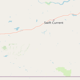
Map view of Great Sandhills National Wildlife Area

Use this park location map to pinpoint Great Sandhills National Wildlife Area in Canada, understand its exact geographic position, and read its mapped placement within the surrounding landscape more clearly.

Pigeon | © OpenStreetMap contributors

Location context for Great Sandhills National Wildlife Area

Saskatchewan
Park atlas

Compare regional grassland reserves and nearby conservation landscapes across the prairies.

Explore Other Parks and Protected Areas Near Great Sandhills National Wildlife Area

Browsing other protected areas near Great Sandhills National Wildlife Area reveals the broader ecological context of southwestern Saskatchewan. Examining adjacent prairie reserves helps connect distinct dune systems and mixed grassland habitats into a cohesive regional overview.
Wildlife reserveSaskatchewan
About 166 km away#1 closest

Northeast

Harris Sandhills National Wildlife Area: Saskatchewan Protected Prairie Geography and Map

Mapped wildlife reserve within the Canadian prairie region.

This protected area in Saskatchewan showcases a distinct mosaic of stabilized dunes and native mixed-grass prairie. Understand its geographic significance as a sanctuary for migratory birds and rare prairie species within the expansive plains of Canada. The reserve offers a focused look at small-scale conservation landscapes through its defined physical boundaries and varied topographic features.

Area
3.7 km²
Established
2025
IUCN
IV
Relief
Lowland
Wildlife reserveSaskatchewan
About 188 km away#2 closest

Southeast

Val Marie Reservoir Migratory Bird Sanctuary: Protected Wetland Geography in Saskatchewan

A critical migratory bird habitat and prairie reservoir

Located in the southwestern plains of Saskatchewan, Val Marie Reservoir Migratory Bird Sanctuary forms a water-dominated mosaic of mudflats, marshes, and nesting islands. This protected area supports the central flyway by maintaining open water for waterfowl, serving as a primary sanctuary for colonial nesting birds within the larger mixedgrass prairie ecosystem.

Area
4.31 km²
Established
1948
IUCN
V
National parkSaskatchewan
About 204 km away#3 closest

Southeast

Grasslands National Park: Saskatchewan Protected Landscape Atlas

Discover its mapped boundaries and regional geographic context.

Grasslands National Park represents a vital component of protected lands in Saskatchewan, Canada, offering rich opportunities for atlas-based geographic exploration. This detail page provides specific insights into the park's mapped boundaries, its natural terrain, and its role as a national park within the broader regional geography. Understand how this protected landscape fits into the larger atlas of Canadian conservation areas and discover its unique geographic identity.

Area
907 km²
Established
1981
IUCN
II
Visitors
19.7K annual
Wildlife reserveSaskatchewan
About 227 km away#4 closest

Southeast

Réserve nationale de faune de Longspur: Saskatchewan Mixed-Grass Prairie Protected Area

Mapping federal wildlife reserve boundaries in southern Saskatchewan.

Located in the Rural Municipality of Val Marie, this wildlife reserve safeguards a rare combination of indigenous mixed-grass prairie and cultivated land. The area functions as a critical sanctuary for nesting songbirds, providing the expansive, open horizon terrain necessary for healthy native grass communities within the larger Saskatchewan agricultural landscape.

Area
1.934 km²
Established
2025
IUCN
IV
Relief
Lowland
A horizontal watercolor painting depicting a soft-focus prairie landscape with grasses and rolling hills.
Wildlife reserveAlberta
About 243 km away#5 closest

Northwest

Spiers Lake National Wildlife Area: Mapping Native Grasslands in Central Alberta

A federally managed reserve for rare prairie flora and bird populations.

Located in the County of Stettler, Spiers Lake National Wildlife Area protects one of the remaining fragments of native fescue prairie in Alberta. The reserve provides essential habitat for rare plants and grassland birds, offering a focused look at the original prairie matrix before agricultural conversion. It is a key example of Canadian federal conservation policy preserving vanishing grassland biodiversity.

Area
0.64 km²
Established
1982
IUCN
Ia
Scope
Terrestrial
Protected areaSutherland
About 252 km away#6 closest

Northeast

Zugvogelschutzgebiet Sutherland: Regional Geography and Protected Area Context

Historic migratory bird habitat in the Saskatchewan prairie landscape

The Zugvogelschutzgebiet Sutherland protected area serves as an important migratory refuge on the Canadian Prairies. While the site integrates diverse land uses including a zoo and research facilities, its remaining native grasslands continue to provide essential feeding and resting grounds for geese, swans, and ducks. This analysis maps the sanctuary within its broader regional context.

Area
1.3 km²
Established
1924
Relief
Lowland
Climate
Temperate
Wildlife reserveSaskatchewan
About 264 km away#7 closest

North

Scent Grass Lake Migratory Bird Sanctuary: Regional Geography and Wetland Protected Area Maps

Key waterfowl breeding and molting ground in Saskatchewan.

Examine the ecological significance of Scent Grass Lake Migratory Bird Sanctuary, a critical wildlife reserve within the Saskatchewan Aspen Parkland. This protected area offers essential open water and sedge marsh environments for migratory waterfowl, serving as a vital staging and breeding site that maintains regional habitat stability in the Canadian prairies.

Area
6.47 km²
Established
1948
IUCN
IV
Relief
Lowland
Wildlife reserveSaskatchewan
About 283 km away#8 closest

Northeast

St. Denis National Wildlife Area: Geographic Profile and Protected Prairie Landscape

A research-focused wildlife reserve in central Saskatchewan.

St. Denis National Wildlife Area represents a critical nexus for prairie ecology, defined by its dense network of shallow ponds and native grassland communities. As a dual-designated National Wildlife and Research Area, this site offers a clear window into the delicate balance of wetland habitats, saline soil conditions, and agricultural landscape integration across Saskatchewan.

Area
3.6 km²
Established
1967
IUCN
IV

Common questions about visiting, size, designation, and location context for Great Sandhills National Wildlife Area

Great Sandhills National Wildlife Area FAQs for park facts, access, geography, and protected area context

Find quick answers about Great Sandhills National Wildlife Area, including protected-area facts, park geography, trail and visitor context, and how the park fits into its surrounding country and regional landscape.
MoriAtlas Explorer

Continue Your Protected Areas Search Across the Global Atlas

Deepen your exploration by continuing the structured search for national parks and protected areas worldwide. Utilize the comprehensive filtering capabilities to compare different conservation landscapes and refine your understanding of global park geography. Discover more about the distribution and characteristics of protected natural areas.

Global natural geography
