

Mori Atlas logo
Nature reserveGrootvadersbosch Nature Reserve

Explore the geographic landscape, valley terrain, and protected forest boundaries of this historic South African reserve.

Grootvadersbosch Nature Reserve: Mapping the Indigenous Forests of the Langeberg Mountains

Grootvadersbosch Nature Reserve serves as a critical protected landscape within the southern foothills of the Langeberg range in South Africa. This atlas entry details the reserve's unique afrotemperate forest environment, its interconnected network of streams rising toward the Slang River, and its layered history as both a conservation area and a nineteenth-century farm estate. By mapping the contours of this valley, users can better understand the regional geography connecting the Overberg to the wider Cape Fold Belt.

afrotemperate forestLangebergOverbergWestern Capeindigenous forestforest reserve

Grootvadersbosch Nature Reserve

Nature reserve

Park overview

Structured park overview, official facts, and landscape profile for Grootvadersbosch Nature Reserve

Grootvadersbosch Nature Reserve park facts, protected area profile, and essential visitor context

Review the core facts for Grootvadersbosch Nature Reserve, including designation, size, terrain, visitor scale, habitats, and operating context in one park-focused overview.

About Grootvadersbosch Nature Reserve

Grootvadersbosch Nature Reserve sits in the southern foothills of the Langeberg, a major mountain range that runs east-west through the Western Cape of South Africa. The reserve covers roughly 250 hectares and is part of the larger Boosmansbos Wilderness Area, which extends the protected landscape further into the mountains behind it. Positioned in the Overberg region, between Barrydale to the west and the Swellendam-Heidelberg corridor to the south, the property occupies a forested valley that has been valued for its timber, water, and agricultural land since the early colonial period.

The dominant ecological feature of Grootvadersbosch is its indigenous forest, the largest surviving native woodland in the Langeberg. This forest is ecologically significant because the region's natural vegetation has largely been cleared or transformed over centuries of farming and timber harvesting, leaving only scattered patches. The reserve protects one of those patches in a state close to its original form, supporting the kind of moist, sheltered microclimate that allows sensitive species of amphibians, reptiles, and birds to persist. Rises in the surrounding watershed include the Slang River and the Duiwenhoks River, both of which draw water from the forested slopes.

Beyond ecology, the reserve carries a strong human story. The farm of Grootvadersbosch was founded in 1724 by Roelof Olofsz and later changed hands through figures including Jacobus Steyn, Governor Hendrik Swellengrebel, and the Moodie family, who purchased the property in 1817. Nineteenth-century visitors to the farm included botanists Carl Peter Thunberg and Francis Masson, explorer François Levaillant, and missionaries James Backhouse and John Philip. Their accounts form an unusually rich documentary record for a Western Cape farm and help explain why Grootvadersbosch is treated as both a natural and a cultural heritage site.

Today, visitors come to Grootvadersbosch primarily for its walking and mountain biking trails, which run through the forest and along the foot of the Langeberg. The combination of old farmstead buildings, forested ravines, and mountain scenery gives the reserve a character that differs from the more open fynbos reserves typical of the region, making it an important complement to the broader protected landscape of the Overberg.

Quick facts and research context for Grootvadersbosch Nature Reserve

Grootvadersbosch is a nature reserve of approximately 250 hectares in the southern Langeberg, within the Overberg district of the Western Cape, South Africa. It lies in the southern reaches of the Boosmansbos Wilderness Area and includes both indigenous forest and a historic farm complex dating to the early 1700s. Rises in the area include the headwaters of the Slang River and the Duiwenhoks River, and the reserve sits between the towns of Barrydale, Swellendam, Suurbraak, and Heidelberg. The property is managed as part of CapeNature's network of protected areas in the Western Cape.

Protection and recognition

Terrestrial protected area classification and administrative records

Grootvadersbosch Nature Reserve Protection Status and Recognition Data

Grootvadersbosch Nature Reserve maintains a documented terrestrial protection status with associated administrative records. Official protected area designation details and management scope outline the operational framework for this reserve.

Protection details

Protection scope
Terrestrial
Transboundary protection
No
Park context

Deeper park guide and search-rich context for Grootvadersbosch Nature Reserve

Grootvadersbosch Nature Reserve history, landscape, wildlife, and travel context

Explore Grootvadersbosch Nature Reserve through its history, landscape character, ecosystems, wildlife, conservation priorities, cultural context, and seasonal travel timing in a structured park guide built for atlas discovery and search intent.

Why Grootvadersbosch Nature Reserve stands out

The reserve is best known for holding the largest remaining tract of indigenous forest in the Langeberg, a fact that gives it a central place in the conservation of afrotemperate forest in the Western Cape. It is also associated with important nineteenth-century natural history visits, including the first European scientific observation of the Cape bushbuck in 1776. Equally distinctive is the Grootvadersbosch dwarf chameleon, an endemic reptile found only in this forested stretch of the Langeberg. The reserve has also gained recognition in herpetology as the site where the elusive Eastern ghost frog was eventually confirmed to be breeding, after more than five decades of searching by local naturalists.
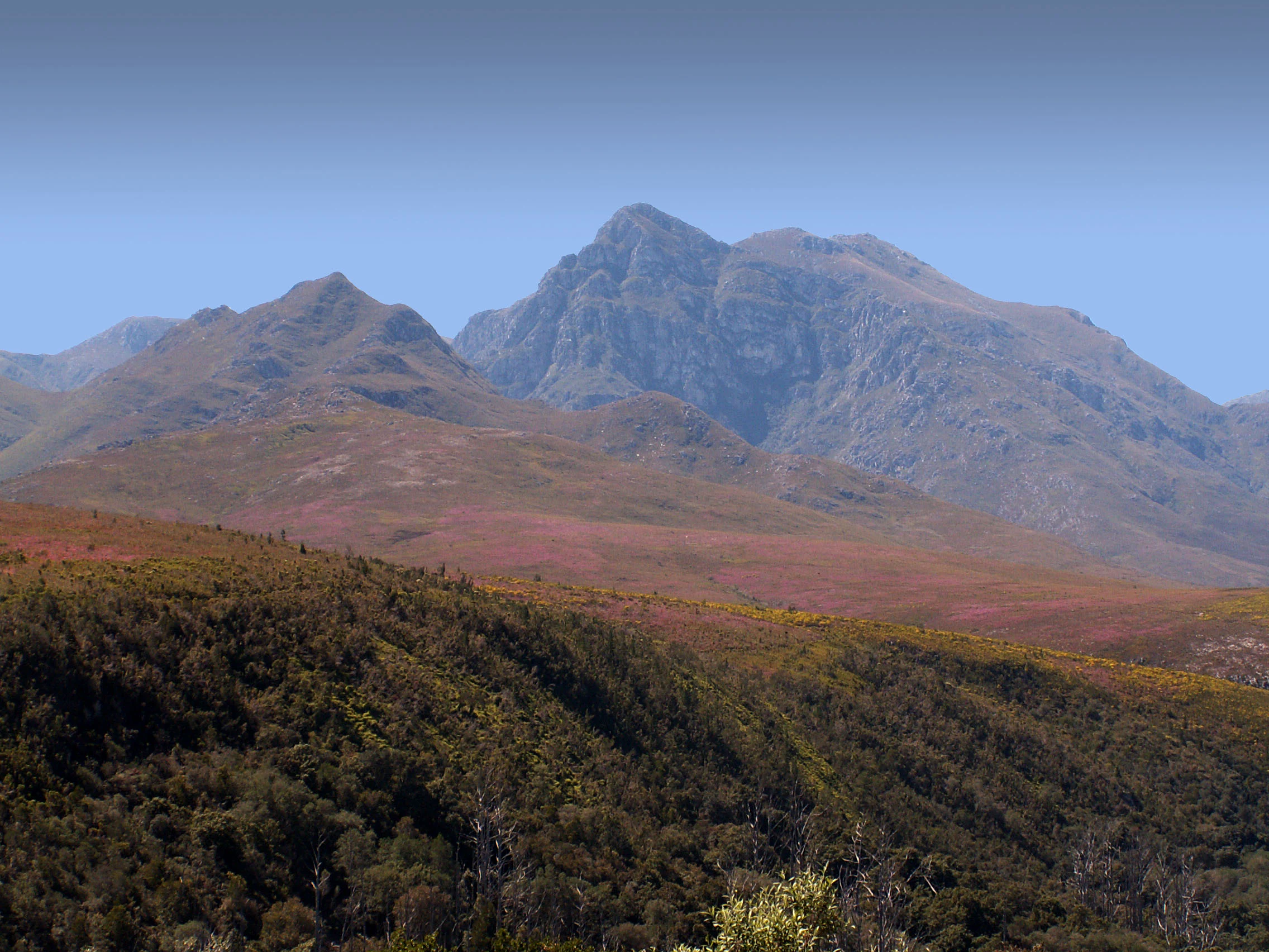
Grootvadersbosch Nature Reserve landscape
Grootberg and mountain scenery in the Boosmansbos and Grootvadersbosch Nature Reserves, Langeberg Range, Western Cape, South Africa.

Grootvadersbosch Nature Reserve history and protected-area timeline

The history of Grootvadersbosch reaches back to the early period of European settlement at the Cape. Soldiers of the Dutch East India Company were among the first to cut timber in the forest, exploiting the high-quality wood that grew in the sheltered Langeberg valleys. Trekboers, the mobile frontier farmers of the Cape interior, subsequently settled in the area, and in 1724 Roelof Olofsz formally founded the Grootvadersbosch farm. The property later passed to Jacobus Steyn, helping to establish a chain of ownership that linked the valley to the broader colonial economy of the Overberg.

A distinctive episode in the farm's history came in 1744, when Hendrik Swellengrebel, Governor of the Dutch Cape Colony, founded a school on the property. Abraham Schietekat served as teacher and ministered to local Boer families, embedding the farm into the religious and educational life of the Cape frontier as well as its agricultural life.

In 1817 the Moodie family purchased Grootvadersbosch, beginning a long period of tenure that would shape the farm's nineteenth-century identity. Under the Moodies, the property became one of the leading farms in the Overberg, producing wood, wheat, fruit, tobacco, wine, and brandy, and serving as a waypoint for a remarkable sequence of foreign visitors. Botanists Carl Peter Thunberg and Francis Masson called at the farm in 1772, even before the Moodie purchase, while the French traveler and naturalist François Levaillant visited in 1782. Missionaries James Backhouse and John Philip passed through in 1830, leaving written impressions of life at Grootvadersbosch.

These visits gave the farm an unusually dense early documentary record, while the post-1817 Moodie period added a substantial layer of nineteenth-century agricultural heritage. The transition of the property into a protected nature reserve in the modern era represents the most recent chapter, in which the old farm estate has been conserved alongside the indigenous forest that surrounds it.

Grootvadersbosch Nature Reserve landscape and geographic character

The landscape of Grootvadersbosch is shaped by the southern foothills of the Langeberg, a long quartzitic mountain range that forms the northern edge of the Overberg. The reserve occupies a forested valley setting within those foothills, with terrain that rises steeply from valley floors into the higher slopes of the range. The indigenous forest fills much of the valley and lower slopes, creating a dark, sheltered canopy that contrasts with the open fynbos vegetation typical of the surrounding lowlands.

Water is a defining feature of the terrain. The Slang River rises in the reserve and the surrounding slopes, as does the Duiwenhoks River, giving the property a network of streams that drain toward the lowlands south of the mountains. These watercourses have carved the valley floor and contributed to the moist microclimate that supports the forest. The valleys around Grootvadersbosch are framed by gravel roads, mountain passes such as the Tradouws Pass, and the corridors linking Swellendam, Barrydale, Suurbraak, and Heidelberg.

At ground level, the reserve mixes old farm infrastructure with forest trails. The historic farm buildings sit within a landscape of forested ridges, clearings, and footpaths that climb toward the wilderness hinterland. Compared to neighboring Boosmansbos Wilderness Area, Grootvadersbosch reads as a more accessible, partially cleared valley landscape, with cultivated history layered onto a still-intact natural forest frame.

Grootvadersbosch Nature Reserve ecosystems, habitats, and plant life

Ecologically, Grootvadersbosch is significant because it preserves the largest surviving area of indigenous forest in the Langeberg. Indigenous forest in this part of the Western Cape is naturally fragmented, and centuries of timber harvesting, grazing, and farming have reduced most original patches to small remnants. The reserve therefore plays a disproportionately important role in conserving afrotemperate forest habitat on the southern Langeberg.

The forest is moist and sheltered, conditions that support a community of amphibians, reptiles, and birds tied to damp, shaded environments. Dense canopy cover, leaf litter, and running streams provide breeding and foraging habitat for species that disappear when forest is cleared. The forest's connection to the larger Boosmansbos Wilderness Area further extends the effective habitat available to species that depend on continuous canopy.

Because the forest sits within a broader landscape dominated by fynbos and farmland, Grootvadersbosch also functions as an ecological island of moist forest in an otherwise drier matrix. This contrast between dense, shaded valley woodland and the sunnier fynbos slopes is a defining ecological feature of the Langeberg south face, and the reserve offers one of the best-preserved examples of that transition in the Overberg.

Grootvadersbosch Nature Reserve wildlife and species highlights

The wildlife profile of Grootvadersbosch is unusually well documented for a reserve of its size, partly because of the long history of European observers at the farm. The Cape bushbuck was first recorded by European scientists in this forest in 1776, when the Swedish naturalist Anders Sparrman visited the area, making the locality a type locality for the species in the Western Cape sense.

Among reptiles, the reserve is most strongly associated with the Grootvadersbosch dwarf chameleon, a vulnerable species endemic to this forested stretch of the Langeberg. Its restricted range gives the reserve a high conservation responsibility for this single taxon. Among amphibians, the property gained recognition when herpetologist John D. Visser, after more than fifty years of searching, finally located eggs of the Eastern ghost frog in the reserve, confirming that the species breeds there.

The reserve's bird and mammal communities are those typical of Langeberg afrotemperate forest, where canopy, streams, and understory provide habitat for small mammals, forest-adapted birds, and routine visitors from surrounding fynbos and farmland. The combination of historically recorded mammals, the endemic chameleon, the breeding population of a rare frog, and the broader forest fauna gives the reserve an exceptional wildlife profile relative to its modest size.

Grootvadersbosch Nature Reserve conservation status and protection priorities

Grootvadersbosch carries a strong conservation significance on two levels. At a landscape level, it represents the largest surviving indigenous forest in the Langeberg and is therefore a key reservoir for forest biodiversity in a region where most original woodland has been lost to grazing, agriculture, and historical timber cutting. Its inclusion in the broader Boosmansbos Wilderness Area extends the protected footprint into the surrounding mountain slopes, increasing the resilience of the forest ecosystem to edge effects and fragmentation.

At a species level, the reserve holds a Vulnerable endemic reptile, the Grootvadersbosch dwarf chameleon, whose entire global range falls within this part of the Langeberg. Protecting any significant portion of that range gives the reserve a direct role in the survival of the species. The confirmed breeding presence of the Eastern ghost frog similarly gives the site value for amphibian conservation, since secretive forest amphibians of this kind are vulnerable to changes in stream flow and canopy cover.

Alongside these biodiversity values, the conservation profile of the reserve is reinforced by the protection of cultural heritage, including the old farm buildings and the historical landscape associated with the Moodie family and earlier colonial owners. The site is managed as part of the Western Cape's provincial nature reserve network under CapeNature, balancing biodiversity protection with public access through hiking and mountain biking trails.

Grootvadersbosch Nature Reserve cultural meaning and human context

Culturally, Grootvadersbosch reads as a layered colonial Cape landscape. The valley has been continuously occupied since at least the early eighteenth century, beginning with Trekboer settlement and the 1724 founding of the farm by Roelof Olofsz, and continuing through successive owners including Jacobus Steyn, the Moodie family from 1817 onward, and various religious and educational institutions linked to Governor Hendrik Swellengrebel's 1744 school under Abraham Schietekat.

This long farm history sits alongside a remarkable sequence of visiting naturalists and missionaries. Carl Peter Thunberg and Francis Masson passed through in 1772, François Levaillant in 1782, and James Backhouse and John Philip in 1830, each leaving written impressions that contribute to the documentary heritage of the Overberg. The Moodie family, in particular, became one of the leading farming dynasties of the Overberg, producing wood, wheat, fruit, tobacco, wine, and brandy and anchoring the social and economic life of the southern Langeberg valleys for much of the nineteenth century.

In the modern era, the farm has been reinterpreted as cultural heritage embedded in a nature reserve, with old buildings, trails, and place names carrying forward the colonial history of the property. The cultural context is not separate from the ecological context: the surviving forest is itself partly a product of which patches were protected, farmed, or logged by successive generations of owners and visitors.

Top sights and standout views in Grootvadersbosch Nature Reserve

The reserve's strongest highlight is its status as the largest surviving indigenous forest in the Langeberg, a distinction that gives it an outsized conservation role in the Western Cape. Within that forest, the endemic Grootvadersbosch dwarf chameleon and a confirmed breeding population of the Eastern ghost frog add specific, high-value wildlife points of interest.

Equally notable is the reserve's deep colonial history, including the 1724 foundation of the farm, the 1744 school founded under Governor Hendrik Swellengrebel, the long Moodie family tenure from 1817, and visits by major eighteenth- and nineteenth-century naturalists such as Sparrman, Thunberg, Masson, Levaillant, Backhouse, and Philip. The combination of protected forest, historic farmstead, and mountain trails in the foothills of the Langeberg makes Grootvadersbosch a place where natural heritage and documented human history sit unusually close together.

Best time to visit Grootvadersbosch Nature Reserve

Grootvadersbosch sits in the southern Cape, where the climate is Mediterranean, with wet, cool winters and drier, warmer summers. Visiting in the cooler, wetter months generally brings the forest into its lushest state, with full canopies, active streams, and the most favorable conditions for amphibians such as the Eastern ghost frog, which depend on damp conditions for breeding. Hikers and mountain bikers tend to find the trails most comfortable during spring and autumn, when temperatures are moderate and the forest understory is neither waterlogged nor parched.

Summer visits can be warmer and drier, but offer longer daylight hours and a higher likelihood of observing reptiles, including the endemic dwarf chameleon, which becomes more active in warmer weather. Winter visits, while cooler and occasionally rainy, can also be rewarding for those interested in forest atmosphere, streamflow, and the historic farm buildings set against a green mountain backdrop. As with any Cape forest reserve, visitors should expect conditions to vary with rain and altitude, and should plan around the seasonal rhythm of the Langeberg south face rather than around fixed dates.
Monthly climate preview

Long-term monthly temperature and precipitation data measured at a representative coordinate

Grootvadersbosch Nature Reserve Climate Normals and Annual Temperature Patterns

Historical climate data for Grootvadersbosch Nature Reserve reveals distinct shifts in monthly mean temperatures and precipitation rates across the recorded period. Detailed monthly averages provide deeper insight into long-term temperature ranges and precipitation patterns for this location.
Annual mean17 °C
11 °C22 °C
Jan22°
Feb22°
Mar21°
Apr18°
May15°
Jun12°
Jul11°
Aug12°
Sep14°
Oct17°
Nov19°
Dec21°
Warmest month
February

22.4 °C

Coolest month
July

11.4 °C

Wettest month
November

1.6 mm/day

Driest month
September

0.9 mm/day

Park location guide

Geography guide, regional context, and park location map for Grootvadersbosch Nature Reserve

Grootvadersbosch Nature Reserve park geography, regions, and map view in South Africa

Understand where Grootvadersbosch Nature Reserve sits in South Africa through a broader geographic reading of the surrounding landscape, nearby location context, and its mapped position within the national park landscape.

How Grootvadersbosch Nature Reserve fits into South Africa

South Africa is the southernmost country in Africa, spanning 1.22 million km² with a population of over 63 million. The country operates with three capital cities, Pretoria (executive), Cape Town (legislative), and Bloemfontein (judicial), and is renowned for its biodiversity, national parks, and multicultural society.

Wider geography shaping Grootvadersbosch Nature Reserve in South Africa

South Africa occupies the southernmost region of Africa, with coastline along both the Atlantic Ocean to the west and the Indian Ocean to the east. The interior features elevated plateaus including the Highveld, with the Drakensberg escarpment marking the eastern highlands. The country shares borders with Namibia, Botswana, Zimbabwe, Mozambique, Eswatini, and Lesotho.

Map view of Grootvadersbosch Nature Reserve

Use this park location map to pinpoint Grootvadersbosch Nature Reserve in South Africa, understand its exact geographic position, and read its mapped placement within the surrounding landscape more clearly.

Pigeon | © OpenStreetMap contributors

Location context for Grootvadersbosch Nature Reserve

Western Cape

Visualizing the indigenous afrotemperate forest and mountain terrain of the Overberg

Grootvadersbosch Nature Reserve Photos and Landscape Scenery Exploration

Visual documentation captures the dense canopy, river valleys, and protected landscapes defining Grootvadersbosch Nature Reserve. Photographic records reveal the physical terrain and ecological habitats sheltered within the Langeberg foothills.

Grootvadersbosch Nature Reserve landscape

Park atlas

Compare adjacent mountain reserves and regional forest landscapes across the Overberg

Other Parks Near Grootvadersbosch Nature Reserve And Surrounding Protected Areas

Visitors exploring Grootvadersbosch Nature Reserve can continue browsing adjacent mountain reserves and regional forest landscapes across the Overberg. Extending the search helps connect isolated valley habitats with broader protected areas throughout the Langeberg foothills.
Protected areaWestern Cape Province
About 8.6 km away#1 closest

Northeast

Boosmansbos Wilderness Area: Geographic Atlas and Protected Landscape Overview

Rugged Langeberg mountain terrain and endemic floral corridors

Boosmansbos Wilderness Area stands as a major protected block in the eastern Langeberg range. This profile maps the diverse topography, ranging from rocky mountain ridges to moist valley forests. Learn about the geographic significance of this wilderness, which encompasses rare botanical species and serves as a vital transition zone between fynbos and indigenous forest habitats within the Western Cape.

Area
142 km²
Relief
Mountain
Climate
Mediterranean
Access
Moderate access
National parkWestern Cape
About 29 km away#2 closest

West

Bontebok National Park: A Unique Protected Landscape in South Africa's Western Cape

Mapping the endemic bontebok's habitat and diverse fynbos.

Bontebok National Park represents a singular achievement in conservation, dedicated to protecting the rare bontebok antelope and showcasing the extraordinary biodiversity of the Cape Floristic Region. Located in the Western Cape, this smallest of South Africa's national parks features a landscape of fynbos-covered foothills beneath the Langeberg Mountains, with the Breede River defining its southern edge. Explore its mapped boundaries and unique ecosystems, offering a concentrated natural discovery experience within a UNESCO World Heritage Site.

Area
27.86 km²
Established
1931
IUCN
II
Relief
Mixed relief
Nature reserveWestern Cape
About 55 km away#3 closest

North

Anysberg Nature Reserve: Geographic Overview and Protected Landscape Mapping

A diverse mountain sanctuary in the Western Cape Karoo.

Anysberg Nature Reserve offers a deep look into the semi-arid mountain geography of South Africa's Western Cape. Spanning a rugged stretch of the Cape Fold Belt, the reserve highlights transitions between fynbos mountain slopes and succulent valley floors. This protected area serves as an essential case study for understanding how topography, ancient river courses, and varied soil conditions influence the distribution of endemic plant life and animal habitats across the Little Karoo region.

Area
796.29 km²
Established
1984
Relief
Mountain
Climate
Mediterranean
Biosphere reserveWestern Cape
About 80 km away#4 closest

East

Gouritz Cluster Biosphere Reserve: Geographic Overview and Protected Area Boundaries

A diverse protected landscape spanning the Western Cape coastline to high mountain ridges.

Spanning from the southern African coast into the interior mountain ranges, this biosphere reserve captures an unmatched variety of landforms including estuaries, rocky headlands, and arid Karoo basins. It serves as a vital protected system for threatened species and endemic flora, representing one of the most ecologically significant landscapes within the Cape Floristic Region.

Area
31,878.9 km²
Established
2015
Relief
Mixed relief
Climate
Mediterranean
Wildlife reserveWestern Cape
About 101 km away#5 closest

East

Gondwana Game Reserve: Geographic Overview of a Southern Cape Rewilding Landscape

Protected mountain and coastal savanna terrain in the Western Cape

Gondwana Game Reserve represents a deliberate conservation effort to restore large mammal populations to the southern coast of South Africa. Situated near the Garden Route, the reserve encompasses a complex mosaic of open plains, rolling hills, and mountain vistas, providing essential habitat connectivity for diverse wildlife species within a protected and managed ecosystem.

Area
110 km²
Relief
Mountain
Climate
Mediterranean
Access
Access unknown
Nature reserveWestern Cape
About 105 km away#6 closest

East

Gamkaberg Nature Reserve: An Atlas Overview of Mountain Geography and Protected Biomes

A vital conservation landscape within the Western Cape of South Africa.

Gamkaberg Nature Reserve stands as a focal point for ecological research and conservation in the Little Karoo. Defined by a rugged mountain range and deep gorges, the reserve protects the critical habitat of the Cape mountain zebra. Its landscape reveals an unusual overlap of four Cape biomes, offering a deep look into the regional geography and biological history of the South African interior.

Area
94 km²
Established
1974
Relief
Mountain
Climate
Mediterranean
National parkWestern Cape
About 111 km away#7 closest

Southwest

Agulhas National Park: National Park Protected Landscape and Geographic Atlas

Mapped boundaries and regional geography in Western Cape.

Agulhas National Park is a protected national park in South Africa's Western Cape, vital for understanding regional geography and mapped landscape features. This entry focuses on its identity as a conservation area, detailing its protected landscape context and geographic setting within the broader atlas of Southern Africa. Explore the specific park boundaries and the unique terrain that defines this significant natural area.

Area
209.59 km²
Established
1998
IUCN
II
Relief
Lowland
Nature reserveWestern Cape
About 120 km away#8 closest

Southwest

Salmonsdam Nature Reserve: Atlas of Protected Landscapes in the Western Cape Overberg

Mountain fynbos, river gorges, and forest catchment geography.

Salmonsdam Nature Reserve is a compact protected expanse in the Overberg mountains of the Western Cape. The reserve encompasses the full Paardensberg River catchment, featuring complex terrain that ranges from high rocky ridges to the wet valley floor of Die Weivlakte. Its geography supports a high concentration of Afromontane forest patches and mountain fynbos habitats within a small, accessible area.

Area
8.34 km²
Established
1962
Relief
Mountain
Climate
Mediterranean

Common questions about visiting, size, designation, and location context for Grootvadersbosch Nature Reserve

Grootvadersbosch Nature Reserve FAQs for park facts, access, geography, and protected area context

Find quick answers about Grootvadersbosch Nature Reserve, including protected-area facts, park geography, trail and visitor context, and how the park fits into its surrounding country and regional landscape.
MoriAtlas Explorer

Continue Your Protected Areas Search Across the Global Atlas

Deepen your exploration by continuing the structured search for national parks and protected areas worldwide. Utilize the comprehensive filtering capabilities to compare different conservation landscapes and refine your understanding of global park geography. Discover more about the distribution and characteristics of protected natural areas.

Global natural geography