
Mori Atlas logo
Nature reserveGroßer Weidenteich

A managed mosaic of open meadows, marshlands, and ponds in the Vogtlandkreis district

Großer Weidenteich: Understanding the Geography and Protected Landscapes of the Saxon Vogtland

(Naturschutzgebiet Großer Weidenteich)

Großer Weidenteich serves as a core example of an open, semi-natural cultural landscape in Saxony. This nature reserve supports an intricate habitat mosaic shaped by traditional sheep grazing, sustaining diverse butterfly and bird populations alongside threatened amphibians. By tracing the water bodies, marshy depressions, and grassy undulations of this Vogtland site, one gains insight into the critical role of actively managed rural environments in preserving regional biological heritage.

nature reserveSaxonyVogtlandkreisopen landscapesheep grazingwet meadow
Stylized digital illustration of a serene mountain valley at sunset, featuring a river, a waterfall in the distance, autumnal trees, and cattails in the foreground.

Großer Weidenteich

Nature reserve

Park overview

Structured park overview, official facts, and landscape profile for Großer Weidenteich

Großer Weidenteich park facts, protected area profile, and essential visitor context

Review the core facts for Großer Weidenteich, including designation, size, terrain, visitor scale, habitats, and operating context in one park-focused overview.

About Großer Weidenteich

Großer Weidenteich is a nature reserve in the Vogtlandkreis district of Saxony, recognized as the largest Naturschutzgebiet in the district. Although its name refers to a pond, the site is fundamentally an open-landscape reserve shaped by long-standing grazing traditions, complemented by wetland pockets, small ponds, and shrubby margins. The protected area lies north of the village of Kobitzschwalde in the municipality of Weischlitz and east of Rößnitz in the municipality of Rosenbach/Vogtl., with the L 297 state road running to its southwest and south.

Designated in 1994 with the official identifier C 58, the reserve is registered internationally in the World Database on Protected Areas (WDPA-ID 163366) and classified under IUCN Category IV as a Habitat/Species Management Area. Approximately 334.9 hectares are placed under formal protection, with management focused on preserving open, sun-exposed habitats and the species assemblages they sustain.

The hydrological backbone of the protected area is the small pond that gives the reserve its name, a roughly 360-meter-long waterbody fed by the Gellingsbach and the Sporner Graben. The outflow continues south as the Gellingsbach into the Syrabach, meaning that the conservation value of the site extends along a connected stream corridor as well as within the immediate pond and meadow margins. This combination of standing water, slow-moving inflow, and seasonally wet grassland creates the conditions that make Großer Weidenteich ecologically distinctive.

The reserve matters within the broader Saxon conservation network because it safeguards an unusually species-rich fragment of traditionally managed open countryside. Where many lowland landscapes in central Europe have been lost to intensification or afforestation, Großer Weidenteich preserves a working mosaic of meadows, pools, shrub patches, and marginal scrub that continues to host threatened native species, including the northern crested newt, the large whiteface dragonfly, and the marsh frog.

Quick facts and research context for Großer Weidenteich

Großer Weidenteich is a designated nature reserve (Naturschutzgebiet) in Saxony, Germany, located in the Vogtlandkreis between the communities of Weischlitz and Rosenbach/Vogtl. It was placed under protection in 1994 and carries the official designation C 58, listed in the World Database on Protected Areas under WDPA-ID 163366. The reserve covers roughly 334.9 hectares and is the largest Naturschutzgebiet in the Vogtlandkreis.

The protected landscape is classified as IUCN Category IV, a Habitat/Species Management Area, and is an open-landscape reserve largely maintained through sheep grazing. A small pond, the Großer Weidenteich itself (about 360 m long), forms the hydrological core of the site, fed by the Gellingsbach and Sporner Graben, with the Gellingsbach continuing downstream into the Syrabach.

Protection and recognition

Documented conservation records, Natura 2000 listings, and administrative framework

Großer Weidenteich Protection Status and International Recognition Data

Protected area parameters for Großer Weidenteich compile official Natura 2000 recognition sources and international database entries. Conservation records outline the recorded designation history and administrative framework associated with the protected landscape.
Park context

Deeper park guide and search-rich context for Großer Weidenteich

Großer Weidenteich history, landscape, wildlife, and travel context

Explore Großer Weidenteich through its history, landscape character, ecosystems, wildlife, conservation priorities, cultural context, and seasonal travel timing in a structured park guide built for atlas discovery and search intent.

Why Großer Weidenteich stands out

Großer Weidenteich is most notable for its extraordinary biodiversity within a comparatively compact Saxon landscape. The reserve is widely associated with nearly 700 documented butterfly species and around 150 bird species, of which about 70 breed on site, a richness that places it among the most species-rich open-land habitats in the Vogtland region. Equally important is its character as a working open landscape maintained by traditional sheep grazing. This management sustains a habitat mosaic of small pools, damp hollows, thorny and shrubby margins, and species-rich meadows that together support threatened amphibians such as the northern crested newt, dragonflies including the large whiteface, and the marsh frog.
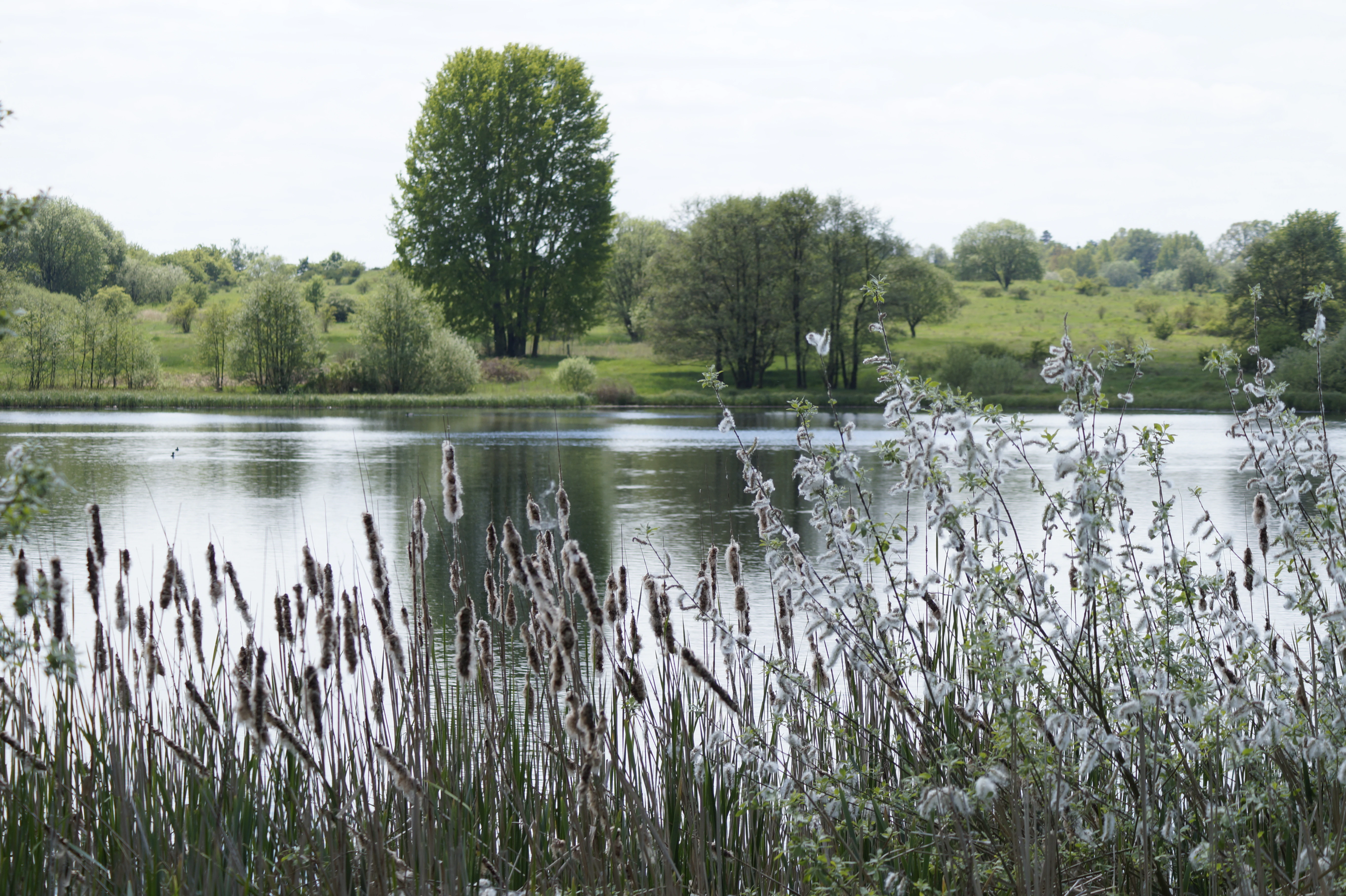
A calm lake viewed through a foreground of reeds and soft, fluffy seed heads, with a grassy shoreline and trees in the background.
The tranquil waters of the Großer Weidenteich nature reserve, framed by reeds and deciduous trees.

Großer Weidenteich history and protected-area timeline

Großer Weidenteich was officially placed under nature protection in 1994, with the designation C 58 marking its formal recognition as a Naturschutzgebiet within the Saxon protected-area system. The timing reflects a broader effort in the years following German reunification to systematically catalogue and protect ecologically valuable open landscapes in Saxony that had previously been maintained through traditional land use rather than formal conservation policy.

Although the 1994 designation is the foundation of the present reserve, its ecological character is rooted in older land-use practices. The predominance of open grassland, the mosaic of small ponds and damp patches, and the persistence of thorny scrub and wildflower-rich meadows all reflect centuries of low-intensity grazing and small-scale water management. The post-1994 management framework formalizes the continuation of these traditional grazing regimes, particularly sheep herding, recognizing that without ongoing disturbance, the site's open habitats and associated species would degrade.

The reserve today is integrated into the Vogtlandkreis network of nature reserves and is listed in regional inventories alongside comparable protected landscapes such as the Syrau-Kauschwitzer Heide, the Sachsenviese, and the Triebtal. Its international track at WDPA-ID 163366 places it within the global World Database on Protected Areas, giving the site an established standing in cross-border conservation reporting.

Großer Weidenteich landscape and geographic character

The landscape of Großer Weidenteich is shaped primarily by open, gently rolling terrain typical of the Saxon Vogtland foothills. Rather than dramatic relief, the reserve is defined by broad meadows, low sward vegetation, and the subtle undulation of pastures, broken by the small standing waters, damp hollows, and slow stream channels that bring ecological contrast to the scene. The reserve's central pond, the Großer Weidenteich, is a modest waterbody stretching roughly 360 meters, fringed with reeds and surrounded by wet meadows that merge into the wider grazing land.

Woody elements in the landscape are present but deliberately scattered. Hawthorn and hazel shrubs, along with sallow willows and elder, form low copses and scrubby transitions rather than closed forest, marking field margins, damp corners, and fencing lines. This pattern of mosaic, open ground interrupted by thorny and woody marginal habitat, gives the reserve its characteristic appearance and supports the species that depend on edge conditions.

The wider setting is rural Saxon countryside, framed by small villages such as Kobitzschwalde and Rößnitz and by the L 297 state road skirting the southern edge of the protected area. Streams entering and leaving the reserve, including the Gellingsbach from the north and the Sporner Graben, shape both the drainage pattern and the distribution of wet habitats. Overall, the visual impression is of a settled, agricultural landscape that retains a strong rural pastoral character precisely because protective grazing has been maintained.

Großer Weidenteich ecosystems, habitats, and plant life

Ecologically, Großer Weidenteich belongs to the category of open, semi-natural cultural landscape, a habitat type that requires ongoing low-intensity human management to persist. Sheep grazing is the principal management tool, preventing the encroachment of woody vegetation and maintaining the open, sun-exposed conditions favored by many of the reserve's characteristic species. Without this grazing pressure, the meadows would gradually succeed into scrub and eventually forest, eliminating the habitat the reserve is designed to protect.

Vegetation in the reserve reflects this managed open character. Hawthorn and hazel shrubs are prominent in the woody component, accompanied by sallow willows and elder that line the wetter zones. In the herbaceous layer, the flora includes creeping restharrow, common thyme, brown knapweed, a type of Dianthus of the heath pink group, stemless thistles, and St. John's wort with other herbaceous components typical of species-rich, traditionally grazed meadows. The combination of grazed grassland, scattered shrubs, and damp pools produces the habitat heterogeneity that supports the site's exceptional species counts.

Wetland habitats are an essential though geographically limited part of the reserve. Small ponds, the central Weidenteich itself, the inflow ditches, and seasonally boggy patches create a network of aquatic and semi-aquatic microhabitats. These elements connect to the broader stream corridor along the Gellingsbach and Syrabach, meaning that the reserve's ecological footprint extends beyond its strictly protected boundary.

Großer Weidenteich wildlife and species highlights

Despite its modest size, Großer Weidenteich supports an exceptionally rich fauna, with a particular reputation among Lepidoptera and breeding birds. Nearly 700 species of butterfly and moth have been documented within the reserve, an extraordinary richness that reflects the diversity of nectar sources, larval host plants, and microclimates maintained across grazed meadow, scrub margin, and pond edge.

Birdlife is equally notable, with around 150 species observed in the reserve area, of which roughly 70 are confirmed nesting species. Breeding bird communities in such habitats typically include species associated with open ground, shrubs, reedbeds, and wetland margins, taking advantage of the reserve's combination of dry meadow, dense thorny scrub, and quiet wet zones.

The wetland component of the reserve supports a particularly valuable set of species. The northern crested newt, a threatened amphibian of conservation concern in Germany, breeds in the reserve's small ponds and damp patches. Dragonfly diversity is also high, with the large whiteface recorded as one of the notable species of these waters. The marsh frog occurs around the ponds and wet meadows, completing a herpetological assemblage that depends on the maintenance of open, grazed landscapes with intact small waterbodies.

Großer Weidenteich conservation status and protection priorities

Großer Weidenteich has been formally protected as a Naturschutzgebiet since 1994 under the identifier C 58 and is internationally classified in the World Database on Protected Areas under WDPA-ID 163366 as an IUCN Category IV Habitat/Species Management Area. This designation emphasizes that the reserve is managed actively for particular habitats and species rather than left to develop without intervention, in line with the needs of its open-land flora and fauna.

The conservation value of the site lies in its combined habitat mosaic: open grazed meadow, thorny and sallow scrub, marshy depressions, small ponds with reedbelts, and inflow and outflow streams. This combination supports threatened invertebrates, amphibians, dragonflies, and breeding birds at densities that would not be sustainable in either intensified farmland or unmanaged woodland. Maintaining sheep grazing is therefore not a cultural choice but a conservation requirement, since the cessation of grazing would shift the successional trajectory toward scrub and forest, eliminating habitat for the very species the protection is designed to sustain.

Within the Saxon and Vogtlandkreis protected-area network, Großer Weidenteich is the largest Naturschutzgebiet and functions as a stronghold for traditionally managed open-land habitats in a region where intensification and reforestation pressures are otherwise strong. Its registration in international databases and its evidence base of nearly 700 butterfly species and around 150 bird species point to its role as a reference site for the conservation of Saxon cultural landscapes.

Großer Weidenteich cultural meaning and human context

The cultural context of Großer Weidenteich is rooted in the long agricultural and pastoral history of the Vogtlandkreis in southwestern Saxony. The open character of the present-day reserve is not a wilderness condition but the product of generations of small-scale farming and grazing, particularly sheep husbandry, which shaped the meadows, shrub margins, and pond systems that now fall under formal protection. Recent conservation designation in 1994 effectively codified and continued a land-use tradition that had already shaped the landscape for centuries.

In the wider Saxon context, the reserve sits among a network of protected cultural landscapes such as the Syrau-Kauschwitzer Heide and various Wiese-style sites, all reflecting the historical importance of grazing and hay management in shaping regional biodiversity. The reserve thus serves both as a refuge for wildlife and as a continuing example of how rural Saxon land-use patterns can be reconciled with modern biodiversity conservation goals.

Top sights and standout views in Großer Weidenteich

Großer Weidenteich stands out as the largest Naturschutzgebiet in the Vogtlandkreis and as a striking example of how an actively grazed Saxon open landscape can support remarkable biodiversity. Its central pond and surrounding wet meadows, threaded with the Gellingsbach and Sporner Graben, sustain threatened amphibians and dragonflies, while the grazed meadows and thorny scrub mosaic host nearly 700 butterfly species and around 150 bird species, with roughly 70 confirmed breeding within the reserve.

The reserve's designation under IUCN Category IV, its registration in the World Database on Protected Areas, and its 1994 designation year all mark it as a firmly established element of both regional Saxon conservation and international protected-area reporting. Its combination of water, marsh, meadow, and shrub habitat, held together by ongoing sheep grazing, gives it a distinctive identity among Vogtlandkreis protected areas.

Best time to visit Großer Weidenteich

As a managed open landscape with sheep grazing and a central pond ringed by reeds, Großer Weidenteich has a strongly seasonal character. Late spring and early summer, roughly May through July, are typically the richest period for flowering meadow plants and for active butterfly and dragonfly activity, when warm weather concentrates invertebrates on the open meadow and around the pond margins. The same period supports the most active bird breeding behavior, with breeding species likely to be most visible and audible across meadows, scrub edges, and reed fringes.

Autumn and winter shift the visual emphasis toward the openness of the grazed pasture, the silhouettes of thorny shrubs and sallow, and the dramatic presence of waterbirds and wintering species on the pond and stream. Short winter days particularly highlight the texture and structure of the open countryside. Visitors interested in wetland habitats will find the various pools and inflow ditches most distinct in calmer, drier weather. Seasonal grazing, frost, and wetland water levels will influence which specific paths and structures are accessible, so checking local conditions is sensible.

Monthly climate preview

Long term temperature ranges and monthly precipitation distributions for Sachsen

Großer Weidenteich Climate Normals and Measured Annual Weather Patterns

Representative coordinate records outline the annual temperature rhythm and monthly precipitation distribution for Großer Weidenteich from 1991 to 2020. Examining the full twelve month profile reveals detailed long term climate norms across all recorded periods.
Annual mean8 °C
-2 °C18 °C
Jan-2°
Feb-1°
Mar
Apr
May12°
Jun16°
Jul18°
Aug18°
Sep13°
Oct
Nov
Dec-1°
Warmest month
July

17.8 °C

Coolest month
January

-2.4 °C

Wettest month
July

2.8 mm/day

Driest month
April

1.4 mm/day

Park location guide

Geography guide, regional context, and park location map for Großer Weidenteich

Großer Weidenteich park geography, regions, and map view in Germany

Understand where Großer Weidenteich sits in Germany through a broader geographic reading of the surrounding landscape, nearby location context, and its mapped position within the national park landscape.

How Großer Weidenteich fits into Germany

Germany is a federal republic in Western and Central Europe with a population of over 83 million across sixteen constituent states. It is Europe's largest economy by nominal GDP and a major global exporter and importer. The capital is Berlin, and the country borders Denmark, Poland, Czech Republic, Austria, Switzerland, France, Luxembourg, Belgium, and the Netherlands.

Wider geography shaping Großer Weidenteich in Germany

Germany is located in Western and Central Europe, spanning 357,022 km². It borders Denmark to the north, Poland and the Czech Republic to the east, Austria and Switzerland to the south, and France, Luxembourg, Belgium, and the Netherlands to the west. The country has coastlines on the Baltic Sea and North Sea to the north, with the Alps located in the southern region.

Map view of Großer Weidenteich

Use this park location map to pinpoint Großer Weidenteich in Germany, understand its exact geographic position, and read its mapped placement within the surrounding landscape more clearly.

Pigeon | © OpenStreetMap contributors

Location context for Großer Weidenteich

Sachsen
Recorded earthquake history

Review the Großer Weidenteich Earthquake History and Recorded Seismic Data

Access the comprehensive catalogue of recorded earthquake activity linked to the geography of Großer Weidenteich. Discover historical seismic event details, including depth and magnitude, curated to provide a precise geographical understanding of the region for researchers and interested observers.

Großer Weidenteich Earthquake History

Catalogued events

131 events

Strongest magnitude

Magnitude 5.1

Most recent event

May 22, 2018

This history includes earthquakes recorded inside the park or within 50 km of its borders

Explore protected area photography, open pastures, and diverse wetland habitats.

Großer Weidenteich Photos and Landscapes: Visualizing Saxony Nature Reserve Scenery

Visual records capture the open meadows, central ponds, and managed scrub mosaic that define Großer Weidenteich. Studying these protected area photographs reveals the unique terrain and habitat structures supporting regional biodiversity.

A calm lake viewed through a foreground of reeds and soft, fluffy seed heads, with a grassy shoreline and trees in the background.

A wide, sunlit landscape view of rolling hills and forests in autumn, featuring golden-yellow foliage on a prominent tree in the foreground and a hazy horizon.

Park atlas

Discover adjacent Vogtland region habitats and compare surrounding Saxon nature reserves.

Explore Parks Near Großer Weidenteich And Related Protected Landscapes

Compare Großer Weidenteich with other protected areas across the surrounding Vogtland region to analyze shared open landscapes and pastoral habitats. Broaden your wildlife tracking by examining adjacent nature reserves and regional conservation zones with similar ecological traits.
A horizontal watercolor painting of a wooden boardwalk path cutting through a forest clearing with scattered pine trees, rendered in soft light tones.
Nature reserveThuringia
10 km away#1 closest

North

Pöllwitzer Wald Nature Reserve: Geographic Overview and Protected Area Mapping

Historic forest landscapes in the Thuringia region

Pöllwitzer Wald represents a dense, historically significant nature reserve located near the Thuringia and Saxony border. This detailed overview covers the essential geographic features, including the unique moorland basin, coniferous forest transitions, and the remnants of early modern log floating infrastructure that shaped the regional topography.

Area
9.62 km²
Relief
Upland
Climate
Temperate
Access
Easy access
A horizontal watercolor painting showing a soft, stylized landscape of rolling green hills, gentle slopes, and a calm body of water against a light pastel sky.
Nature reserveThuringia
19 km away#2 closest

Northwest

Plothener Teiche Nature Reserve: Geographic Map and Protected Wetland Landscape Overview

Historic pond landscapes in the Saale-Orla-Kreis region of Thuringia

Plothener Teiche serves as a defining example of medieval-origin fishpond management in central Germany. This protected landscape combines open water basins, reed-lined margins, and woodland edges within the Thüringer Schiefergebirge and Obere Saale Nature Park. The area provides essential habitat for migratory bird populations and stands as a restored model of European wetland ecology.

Established
1967
IUCN
IV
Relief
Lowland
Climate
Temperate
Protected landscapeBavaria
20 km away#3 closest

Southwest

Naturpark Frankenwald: Geographic Profile of Bavaria's Forested Protected Landscape

A vast, interconnected upland spanning the Bavaria and Thuringia border

Naturpark Frankenwald functions as a large-scale managed nature preserve that integrates cultural heritage with ecological conservation. The terrain consists of gentle mountainous ridges, narrow river valleys, and extensive mixed forests that form a continuous landscape belt across northern Bavaria. This profile provides an overview of the regional geography, boundary extent, and the natural features that define this significant central German upland area.

Area
1,023 km²
Established
1973
Relief
Upland
Climate
Temperate
A horizontal watercolor illustration showing soft green hills, forest patches, and distant pale pink mountains.
Nature reserveThuringia
About 21 km away#4 closest

West

Kobersfelsen Nature Reserve: Silicate Cliff Geography and Protected Valley Landscapes

Geographic context for the Thuringian Slate Mountains protected area.

Kobersfelsen features a significant silicate rock outcrop rising above the Saale valley. As part of a larger Habitats Directive site, this nature reserve integrates cliffside forest with rare botanical communities. Users can examine the specific site boundaries and understand its role within the wider ecological network of the Thuringian region.

Area
0.06 km²
Established
1989
IUCN
IV
Relief
Upland
Protected areaThuringia
About 23 km away#5 closest

Northeast

Wälder um Greiz und Werdau: Protected Landscape and Regional Woodland Atlas for Thuringia

Continuous forest terrain on the Thuringia and Saxony border

The protected landscape of Wälder um Greiz und Werdau covers rolling hills and valleys between the Pleiße and Weiße Elster rivers. Use this atlas resource to understand the park's mapped boundaries, forest pond distribution, and its role as a green corridor between regional townscapes.

Area
62 km²
Established
1961
Relief
Upland
Climate
Temperate
Nature reserveSaxony
25 km away#6 closest

Northeast

Waschteich Reuth Nature Reserve: Mapped Wetland Landscapes of the Saxony Vogtland

Protected pond habitats and regional woodland ecosystems

Waschteich Reuth serves as a compact yet ecologically rich nature reserve in the Vogtland. Its protected boundaries encompass a traditional pond with floating-leaf vegetation, damp meadows, and native oak-hornbeam forest. This site stands as a prime example of Saxony's wetland heritage, illustrating the importance of small-scale habitat preservation within the broader German river network.

Area
0.212 km²
Established
1995
Water
Major water bodies
Natural monumentKarlovarský kraj
About 32 km away#7 closest

Southeast

Vernéřovské doly Natural Monument: A Geological Landmark in the Karlovarský kraj

Rare pegmatite mineralogy and historic mining terrain in western Czechia.

Located in the Cheb District, Vernéřovské doly functions as a specialized natural monument dedicated to preserving a quartz-amblygonite-microcline vein system. This protected area provides a window into hydrothermal ore formation, featuring geological structures comparable only to sites in Portugal and the Ural Mountains.

Area
0.003 km²
Established
1999
IUCN
III
Relief
Upland
A horizontal watercolor illustration of a gentle landscape with scattered trees, soft green foliage, and faint mountain outlines in the background.
Nature reserveSaxony
About 34 km away#8 closest

East

Am Riedert Nature Reserve: Protected Mountain Forest Geography in Saxony, Germany

Analyzing the ecological boundaries and Hercynian mountain mixed forest terrain

Am Riedert is a compact but ecologically important nature reserve situated on the rugged slopes of the western Erzgebirge. This site protects a significant example of mountain mixed forest, characterized by its mature silver fir populations and active natural regeneration. By examining its location south of the Zwickauer Mulde river, visitors can trace the intersection of Saxon history and conservation within this unique protected landscape.

Area
0.185 km²
Established
1961
IUCN
IV
Relief
Mountain

Common questions about visiting, size, designation, and location context for Großer Weidenteich

Großer Weidenteich FAQs for park facts, access, geography, and protected area context

Find quick answers about Großer Weidenteich, including protected-area facts, park geography, trail and visitor context, and how the park fits into its surrounding country and regional landscape.
MoriAtlas Explorer

Continue Your Protected Areas Search Across the Global Atlas

Deepen your exploration by continuing the structured search for national parks and protected areas worldwide. Utilize the comprehensive filtering capabilities to compare different conservation landscapes and refine your understanding of global park geography. Discover more about the distribution and characteristics of protected natural areas.

Global natural geography