Mori Atlas logo
Nature reserveGirutiškio gamtinis rezervatas

Discover the unique hydrology of thermokarst lakes and raised bog landscapes within the Labanoras forest network.

Girutiškio gamtinis rezervatas: Mapping the Protected Peatlands and Boreal Wetlands of Eastern Lithuania

Girutiškio gamtinis rezervatas stands as a crucial protected area in the Švenčionys District Municipality, preserving a mosaic of raised bogs, relict lakes, and pine-dominated woodlands. This nature reserve serves as an essential reference for boreal wetland conservation, recognized internationally for its thermokarst-origin hydrological systems and peatland biodiversity. Through detailed geographic mapping, examine how the landscape integrates with the surrounding Labanoro forest to form a compact, strictly managed wilderness.

nature reserveIUCN Category Iastrict nature reservepeatlandraised bogwetland

Girutiškio gamtinis rezervatas

Nature reserve

Park overview

Structured park overview, official facts, and landscape profile for Girutiškis Nature Reserve

Girutiškis Nature Reserve park facts, protected area profile, and essential visitor context

Review the core facts for Girutiškis Nature Reserve, including designation, size, terrain, visitor scale, habitats, and operating context in one park-focused overview.

About Girutiškis Nature Reserve

Girutiškis Nature Reserve is a strictly protected natural area situated in the eastern part of Lithuania, within the Švenčionys district municipality and the Aukštaitija region. It is integrated into Labanoras Regional Park, which itself forms a portion of the broader Labanoro Forest, one of the largest and most ecologically significant forest massifs in the country. The reserve's location positions it deep within a continuous belt of pine-dominated woodland and peatland that defines much of northeastern Lithuania's natural character.

The defining feature of the reserve is its wetland heart. The Girutiškis bog complex and the Beržalotas raised bog together form a remarkable peatland landscape that developed on the site of ancient lakes. Beržalotas, covering roughly 245 hectares, contains ten relict lakes and represents one of the classic examples of bog-and-lake coexistence in the Baltic region. Nearby, the Girutiškis thermokarst lake and four smaller companion lakes sit enclosed within a high bog, giving the area its distinctive pattern of open water, floating peat margins, and wooded hummocks.

Peat depths in the reserve vary significantly, with maximum measurements reaching 8.4 meters in parts of the Beržalotas bog and average depths around 3.5 meters. Beneath the peat lies a thin layer of lacustrine sapropel over sandy and clay substrates, documenting the area's evolution from open lake to raised bog. The surrounding forests are dominated by Scots pine, with mire margins, pine bogs, and wet depressions blending into the broader woodlands.

Ecologically, Girutiškis stands out for its combination of peatland integrity and biodiversity. The reserve has been documented as hosting about 187 vertebrate species, of which 145 are birds, alongside eight recorded fish species in its waters. Roughly 100 animal and plant species recorded here appear in Lithuania's Red Data Book categories, reflecting the site's high conservation value. The reserve is particularly important for bog-breeding birds, rare mire plants, and characteristic peatland mosses.

Quick facts and research context for Girutiškis Nature Reserve

Girutiškis Nature Reserve is located in eastern Lithuania, within the Švenčionys district municipality and the Aukštaitija ethnographic region. The reserve lies about six to eight kilometers from the nearest larger towns of Labanoras and Švenčionėliai and is surrounded by forests administered by the Švenčionėliai forestry enterprise.

It is governed as part of Labanoras Regional Park and forms a core protected area within the larger Labanoro Forest ecosystem. The reserve's territory is elongated north to south and features elevations ranging roughly between 147 and 163 meters above sea level.

IUCN protection category: Ia (strict nature reserve). In 2011, it was internationally recognized through its inclusion on the Ramsar List of Wetlands of International Importance (site number 1993).

Park context

Deeper park guide and search-rich context for Girutiškis Nature Reserve

Girutiškis Nature Reserve history, landscape, wildlife, and travel context

Explore Girutiškis Nature Reserve through its history, landscape character, ecosystems, wildlife, conservation priorities, cultural context, and seasonal travel timing in a structured park guide built for atlas discovery and search intent.

Why Girutiškis Nature Reserve stands out

Girutiškis is best known for its thermokarst-origin wetland complex, combining the Girutiškis raised bog, the Beržalotas raised bog with its ten relict lakes, and a cluster of small lakes connected to ancient peat-forming processes. These peatlands are among the most ecologically distinctive in Lithuania and have given the reserve an international profile through Ramsar recognition. The reserve is also notable for hosting one of Lithuania's largest populations of dwarf birch, along with rare sedge, lobelia, and orchid species tied to bog and bog-margin habitats. Together, these features make Girutiškis an important reference site for northern peatland and bog-lake conservation in the Baltic region.
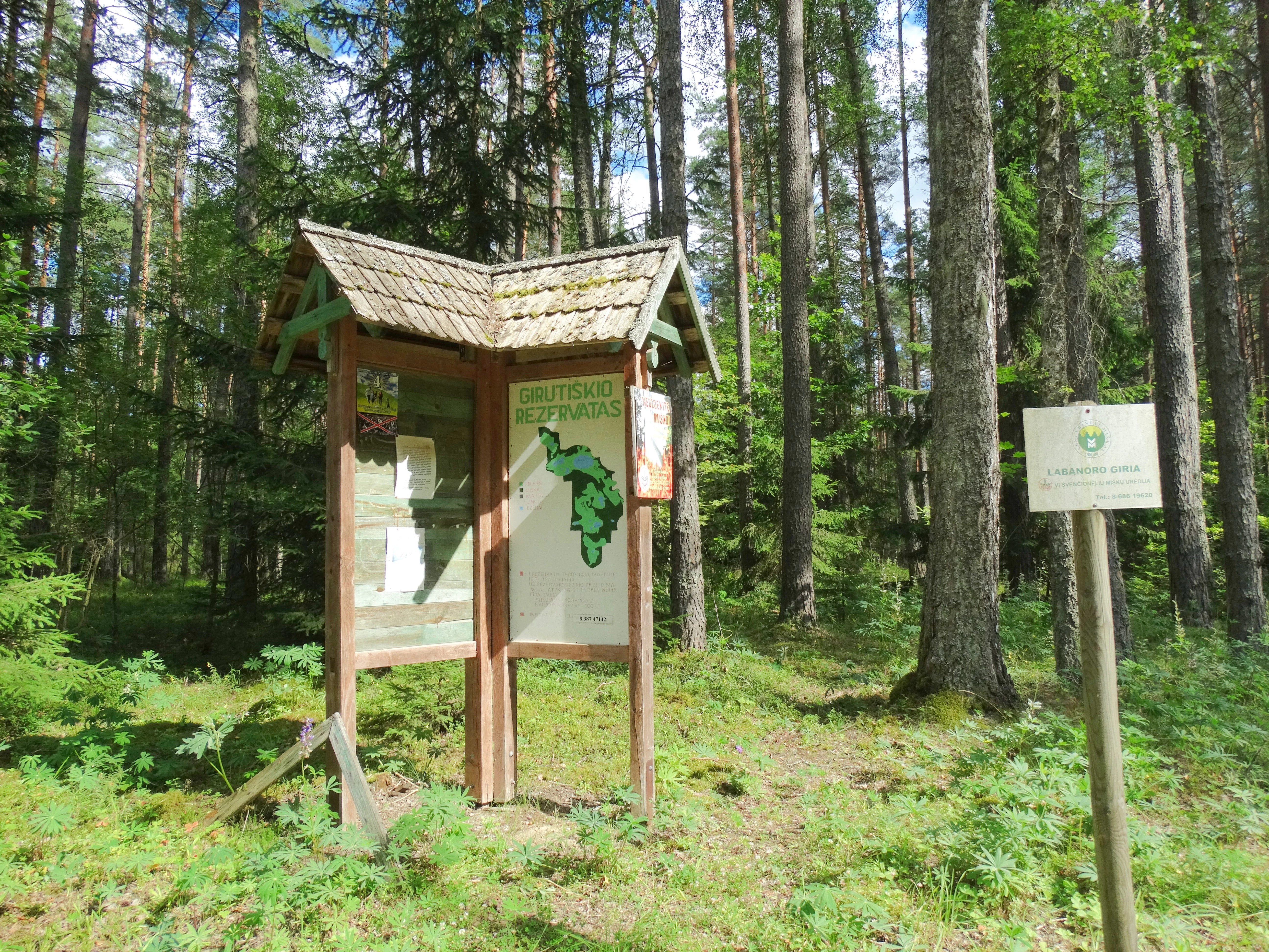
A wooden informational signboard with a map and park name stands in a pine forest, with a smaller secondary sign on a post to the right.
An informational signboard at the entrance of the Girutiškis Nature Reserve within the Labanoras forest.

Girutiškis Nature Reserve history and protected-area timeline

The area that today forms Girutiškis Nature Reserve has a layered history of protection. The reserve was formally established on the foundation of two earlier, more narrowly focused reserves: the Beržalotas botanical reserve, created in 1974 to protect a cranberry-rich peatland, and the Baranava botanical-zoological reserve, established in 1960.

By consolidating these two older protected zones under a single management framework as part of the Labanoras Regional Park system, Lithuanian conservation authorities created a unified site that recognizes the broader ecological significance of the wetland complex, including its lakes, peat-forming processes, and biodiversity.

In 2011, this regional significance was elevated to international status when the Ramsar Convention Secretariat inscribed the reserve on the List of Wetlands of International Importance (site number 1993). This Ramsar designation, dating back to the original 1971 convention in Iran, underlines the site's place within the global network of important peatland and wetland ecosystems.

Girutiškis Nature Reserve landscape and geographic character

Girutiškis Nature Reserve occupies an elongated territory stretching broadly north to south through the eastern Lithuanian landscape. Its terrain is relatively low-lying, with elevations ranging from about 147 meters to roughly 163 meters above sea level, creating gentle undulations rather than dramatic relief. The result is a quiet, ecologically compact landscape of forest, bog, and lake rather than a high-energy topographic setting.

The most visually and ecologically defining landscape elements are the peatlands. The Girutiškis high bog in the northern part of the reserve centers on the thermokarst Girutiškis Lake and its companion lakes, while the Beržalotas raised bog in the south expands across roughly 245 hectares and contains ten relict lakes scattered across the open peat surface. These open peatland expanses contrast sharply with the dense pine forests that frame the reserve, producing a mosaic of dark conifer woodland and bright, open mire.

Hydrologically, the reserve is largely closed. No permanent streams flow into or out of the Girutiškis bog itself; instead, excess spring meltwater drains slowly across low hummocks toward the Peršokšna and Luknelė streams on the margins. The Luknelė stream traces part of the northeastern border, while a section of the Palukna stream passes through the southeast corner, shaping the hydrological boundaries of the peatlands.

Girutiškis Nature Reserve ecosystems, habitats, and plant life

The reserve forms a core ecological island within the Labanoro Forest ecosystem, one of Lithuania's largest continuous forest complexes. Its ecological value rests on the combination of pine-dominated forest, thermokarst lakes, raised bogs, and transitional mire communities, all preserved under a strict IUCN Category Ia protection regime.

Vegetation patterns in the reserve reflect the strong control of peat and water. Surrounding forests are overwhelmingly Scots pine stands, while within the mires themselves, characteristic bog vegetation dominates, including peat-forming mosses, sedges, and specialized bog shrubs. The reserve is particularly notable for hosting one of Lithuania's largest populations of dwarf birch, a relict species of cold, open peatland environments.

Among flowering plants, the reserve supports aquatic and peatland specialists such as lake lobelia, slender sedge, bog sedge, and tall fragrant orchid, alongside water lily and other moisture-dependent species. Bog-margin habitats create additional niches for rare vascular plants and a notable community of protected bryophytes, including rare mosses that contribute to the site's botanical importance.

Girutiškis Nature Reserve wildlife and species highlights

Girutiškis is recognized primarily as a bird-rich reserve and a key site for peatland-associated fauna in Lithuania. Approximately 187 vertebrate species have been documented within its boundaries, of which 145 are bird species, indicating an exceptionally rich avifauna for an area of this size. The reserve serves as nesting habitat and refuge for numerous species of conservation concern.

The bird list includes globally and regionally rare bog and forest specialists such as black storks, white-tailed eagles, lesser spotted eagles, black grouse, great snipe, corncrakes, golden plovers, and both common and three-toed woodpeckers. Wetland-margin species like grey herons and grey geese also use the lakes and bog pools of the reserve. Raptor species recorded include short-toed snake eagle and, historically, black vulture.

Mammals of conservation interest also inhabit the reserve, including lynx, European mink, white hare, and birch mouse. Aquatic habitats support eight recorded fish species, completing a faunal profile that emphasizes the site's role in maintaining populations of wetland- and forest-dependent species across multiple trophic levels.

Girutiškis Nature Reserve conservation status and protection priorities

Girutiškis Nature Reserve operates at the highest tier of nature protection in Lithuania, classified as an IUCN Category Ia strict nature reserve. This designation means that the reserve is managed primarily for ecosystem preservation, biodiversity protection, and scientific research, with human intervention kept to a minimum in order to maintain natural processes.

The reserve's core conservation significance lies in the preservation of thermokarst-origin mires, raised bogs, and relict bog lakes that have developed over thousands of years. By protecting the integrity of peat-forming processes, water chemistry, and open bog habitats, the reserve safeguards carbon stores, hydrological function, and a distinctive suite of species that cannot survive in heavily modified landscapes.

Recognition under the international Ramsar Convention in 2011 confirms the reserve's importance beyond national borders. Approximately 100 animal and plant species recorded here appear in Lithuania's Red Data Book categories, covering rare birds, mammals, vascular plants, and bryophytes, making Girutiškis a focal point of Lithuania's contribution to wetland conservation in the Baltic region.

Top sights and standout views in Girutiškis Nature Reserve

The combination of thermokarst lakes, raised bogs, and surrounding pine forest makes Girutiškis one of the most authentic peatland landscapes in Lithuania. Its relict bog lakes, deep peat deposits, and closed hydrology give the site a near-pristine character unusual for lowland European reserves.

Internationally, the reserve stands out for its 2011 Ramsar designation, placing it within the global network of wetlands recognized for their ecological and hydrological value. Nationally, it is celebrated for hosting one of Lithuania's largest dwarf birch populations and an unusually rich avifauna for a compact inland protected area.

Best time to visit Girutiškis Nature Reserve

As a strict nature reserve, Girutiškis is primarily a conservation site rather than a heavily visited tourism destination. For those interested in its landscape, spring and early summer bring the most active birdlife, including breeding activity among bog and forest species, while late spring and early summer also showcase the flowering of bog-margin plants.

Late summer and early autumn can be appealing for observing the open character of the raised bogs, including berry-producing peatlands historically associated with cranberry harvesting. Winter transforms the reserve into a stark, quiet landscape of snow-covered pine forest and frozen bog pools, though accessibility through surrounding forest tracks may be limited by seasonal conditions.
Monthly climate preview

Representative temperature and precipitation averages across the protected area

Girutiškio gamtinis rezervatas Climate Normals and Monthly Weather Records

Girutiškio gamtinis rezervatas exhibits a measured annual climate rhythm spanning freezing winter minimums and warm summer peaks alongside steady precipitation rates. Reviewing the complete twelve-month record reveals detailed monthly temperature distributions and long-term precipitation averages across the protected terrain.
Annual mean6 °C
-6 °C18 °C
Jan-6°
Feb-6°
Mar-1°
Apr
May12°
Jun16°
Jul18°
Aug17°
Sep12°
Oct
Nov
Dec-4°
Warmest month
July

18 °C

Coolest month
January

-6.5 °C

Wettest month
July

3.1 mm/day

Driest month
March

1.6 mm/day

Park location guide

Geography guide, regional context, and park location map for Girutiškis Nature Reserve

Girutiškis Nature Reserve park geography, regions, and map view in Lithuania

Understand where Girutiškis Nature Reserve sits in Lithuania through a broader geographic reading of the surrounding landscape, nearby location context, and its mapped position within the national park landscape.

How Girutiškis Nature Reserve fits into Lithuania

Lithuania is a unitary semi-presidential republic and one of three Baltic states in Northern Europe. It lies on the eastern coast of the Baltic Sea, with Vilnius as its capital and largest city. The country regained independence in 1990 after Soviet occupation and joined the European Union in 2004. Lithuania has a population of about 2.9 million and covers an area of 65,300 km².

Wider geography shaping Girutiškis Nature Reserve in Lithuania

Lithuania is situated on the eastern shore of the Baltic Sea in Northern Europe. It borders Latvia to the north, Belarus to the east and south, Poland to the south, and Russia's Kaliningrad Oblast to the southwest. The country also has a maritime border with Sweden to the west. The terrain is largely flat with rolling hills, numerous lakes, and rivers. The Nemunas River is the longest river in the country.

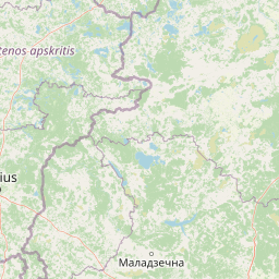
Map view of Girutiškis Nature Reserve

Use this park location map to pinpoint Girutiškis Nature Reserve in Lithuania, understand its exact geographic position, and read its mapped placement within the surrounding landscape more clearly.

Pigeon | © OpenStreetMap contributors

Location context for Girutiškis Nature Reserve

Švenčionys District Municipality

Visual reference for raised bogs, thermokarst lakes, and pine woodlands

Girutiškio gamtinis rezervatas Photos and Landscape Scenery

Visual records reveal the diverse terrain and delicate habitats preserved across the strict wetland reserve. Photographic documentation allows researchers and conservationists to examine the pristine character of the boreal peatlands and surrounding forest ecosystems.

A wooden informational signboard with a map and park name stands in a pine forest, with a smaller secondary sign on a post to the right.

Park atlas

Compare adjacent wetland reserves and surrounding regional forest landscapes

Other Parks and Protected Areas Near Girutiškio Gamtinis Rezervatas

Browsing other protected areas near Girutiškio gamtinis rezervatas reveals connected regional forest and wetland terrain. Comparing these adjacent habitats provides a broader geographic understanding of Baltic peatland conservation.
Watercolor painting of a lake surrounded by trees with a sunset sky
National parkLithuania
About 5.1 km away#1 closest

Northeast

Aukštaitija National Park: Lithuania's Oldest National Park and Protected Landscape Exploration

Mapped geography and lake district atlas for this Baltic region park.

Delve into Aukštaitija National Park, Lithuania's pioneering national park and a key protected area in the Baltic region. This detailed atlas entry highlights its defining geography: an extensive mosaic of over 120 lakes interwoven with ancient pine forests across undulating highlands. Understand the park's protected landscape, its mapped boundaries, and its ecological significance within Eastern Europe's natural terrain.

Area
410.56 km²
Established
1974
IUCN
II
Relief
Upland
Nature reserveŠvenčionys District Municipality
About 8.6 km away#2 closest

North

Kiauneliškio gamtinis rezervatas: Ancient Forest Landscapes and Protected Terrain Mapping

Nature reserve geography in Švenčionys District Municipality

Kiauneliškio gamtinis rezervatas protects 283 hectares of moist, sandy pine woodland characterized by glacial ridges and historic old-growth specimens. This site acts as an ecological reference for the Labanoro forest landscape, offering clear insights into the undulating lowland topography and rare interior habitats of eastern Lithuania.

Area
2.83 km²
IUCN
Ia
Relief
Lowland
Climate
Temperate
Biosphere reserveAnykščiai District Municipality
About 59 km away#3 closest

Northwest

Šimonių Giria Biosphere Reserve in Anykščiai District Municipality, Lithuania

Protected forest massif and glacial landscape mapping

Šimonių giria stands as a prominent biosphere reserve in northern Lithuania, offering an expansive, pine dominated woodland defined by post glacial sands, extensive peat bogs, and a network of interior lakes. This structured overview details the park geographical features, from its role in the Natura 2000 network to its critical function as a biodiversity monitoring site within the Anykščiai District Municipality.

Area
232.61 km²
Established
2004
Relief
Lowland
Climate
Temperate
Watercolor painting showing a lake with small forested islands and distant horizon.
National parkMinsk Region
About 67 km away#4 closest

Southeast

Narachanski National Park: Belarus's Premier National Park and Lake District Atlas

Explore protected glacial terrain and diverse lake systems.

Narachanski National Park is the crown jewel of Belarus's lake district, a protected national park safeguarding a landscape defined by glacial origins and extensive freshwater systems. Centered around Lake Narach, the park's territory within Minsk Region showcases a varied terrain of moraine hills, depressions, and over 30 lakes. This atlas perspective highlights the park's unique geological features, extensive forests, and its role as a vital protected area for understanding regional geography.

Area
933 km²
Established
1999
IUCN
II
Relief
Lowland
Biosphere reserveLithuania
About 82 km away#5 closest

West

Taujėnų, Užulėnio miškų biosferos poligonas: Protected Forest Landscapes of Lithuania

Central Baltic lowland conservation territory

Spanning central Lithuania, this biosphere reserve preserves a vast mosaic of deciduous, coniferous, and mixed forest lands. The territory supports high-quality bird habitats through disciplined forestry practices and the protection of complex wetland and peatland systems, making it a reference site for lowland forest conservation.

Area
44.19 km²
Established
2004
Relief
Lowland
Climate
Temperate
Biosphere reserveUkmergė District Municipality
About 84 km away#6 closest

West

Viliukų, Karpių miškai Biosphere Reserve: Regional Protected Area Geography and Maps

Broadleaved forests and wetland ecosystems in central Lithuania

Gain insights into the protected landscape of Viliukų, Karpių miškai in the Ukmergė District. This biosphere reserve provides a detailed view of lowland forest ecosystems, characterized by spruce and birch dominance within an undulating terrain that sustains rare insect and plant communities.

Area
7.772 km²
Established
2012
Relief
Lowland
Scope
Terrestrial
Watercolor painting showing a lake surrounded by trees and rolling hills
National parkBelarus
About 87 km away#7 closest

Northeast

Braslaw Lakes National Park: Protected Glacial Lake Landscape Atlas

Mapped boundaries and terrain of a key Belarusian protected area.

Braslaw Lakes National Park presents a fascinating protected landscape defined by its extensive glacial lake chain, lush forests, and vital wetland ecosystems. As a significant natural region in northern Belarus, it offers valuable insights into lacustrine environments and glacially formed terrain. This park serves as a prime example of protected land within the Vitebsk Region, ideal for exploring its mapped geography, understanding its ecological importance, and appreciating the unique character of Eastern Europe's lake districts through a structured atlas lens.

IUCN
II
Nature reserveTrakai District Municipality
About 109 km away#8 closest

Southwest

Mergiškių gamtinis rezervatas Protected Nature Reserve in Trakai District Municipality

Strictly protected hornbeam woodland and hilly glacial terrain

Mergiškių gamtinis rezervatas is a protected area in Lithuania dedicated to conserving mature hornbeam-dominated hill forest. Located within the Trakai District Municipality, the reserve provides a critical habitat for threatened species and maintains the natural integrity of hilly glacial landscapes typical of the Aukštadvaris region.

Area
1.57 km²
Established
1996
IUCN
Ia
Relief
Upland

Common questions about visiting, size, designation, and location context for Girutiškis Nature Reserve

Girutiškis Nature Reserve FAQs for park facts, access, geography, and protected area context

Find quick answers about Girutiškis Nature Reserve, including protected-area facts, park geography, trail and visitor context, and how the park fits into its surrounding country and regional landscape.
MoriAtlas Explorer

Continue Your Protected Areas Search Across the Global Atlas

Deepen your exploration by continuing the structured search for national parks and protected areas worldwide. Utilize the comprehensive filtering capabilities to compare different conservation landscapes and refine your understanding of global park geography. Discover more about the distribution and characteristics of protected natural areas.

Global natural geography