Mori Atlas logo
Natural monumentGusiny perelet

Mapping the geological exposure and landscape context of an ancient Hipparion fauna fossil locality

Gusiny Perelet: A Significant Paleontological Natural Monument along the Irtysh River in Kazakhstan

(Gusiny Perelet (Paleontological Natural Monument of Republican Significance))

Gusiny Perelet represents a critical geological window into the Late Neogene period, situated on the right bank of the Irtysh River within Pavlodar. This protected natural monument preserves an extensive assemblage of vertebrate fossils, including classic Hipparion fauna members such as saber-toothed Machairodus and diverse herbivores. The site offers a unique perspective on the ancient steppe environment through its layered sediment exposures and long history of scientific research.

paleontological sitehipparion faunafossil localityneogene fossilsvertebrate fossilsnatural monument

Gusiny perelet

Natural monument

Park overview

Structured park overview, official facts, and landscape profile for Gusiny Perelet

Gusiny Perelet park facts, protected area profile, and essential visitor context

Review the core facts for Gusiny Perelet, including designation, size, terrain, visitor scale, habitats, and operating context in one park-focused overview.

About Gusiny Perelet

Gusiny Perelet occupies an exposed slope along the right bank of the Irtysh River in Pavlodar, northeastern Kazakhstan. Although described today as a paleontological site rather than a traditional natural park, it functions as a protected area of high scientific and cultural value, recognized as a natural monument of republican significance since the early 2000s. The site preserves a vertical geological section in which the bones of long-extinct animals are embedded in Neogene sediments laid down between approximately 4 and 4.5 million years ago.

The primary significance of Gusiny Perelet lies in the richness and diversity of its vertebrate assemblage. The fossil-bearing layer has yielded more than 60 species of vertebrates representing the Hipparion fauna, an ecological community dominated by three-toed horses of the genus Hipparion alongside a wide array of associated mammals. Among the most frequently cited finds are Chilotherium, a hornless rhinoceros typical of Late Miocene Eurasian faunas; Sinotherium, a massive, long-horned rhinocerotid; Lagomerix, a large deer-like ruminant; and Samotherium, a tall giraffid with distinctive ossicones. Predators in the assemblage include Machairodus saber-toothed cats, while the rodent component of the site is unusually diverse for the region.

Beyond its paleontological importance, the site has acquired public and cultural identity for the city of Pavlodar. The very name "Gusiny Perelet," which translates roughly as "Goose Flight," alludes to a local legend and reflects how this stretch of the Irtysh has long been part of the regional imagination. The establishment of an open-air museum on the site in 2019 marked a deliberate shift from purely scientific use toward heritage interpretation, making the locality accessible to visitors while protecting the remaining fossil-bearing layers from further uncontrolled excavation. As a result, the site now bridges three overlapping roles: a working paleontological reference, a protected natural monument, and a city-level cultural landmark.

Quick facts and research context for Gusiny Perelet

Gusiny Perelet is a paleontological natural monument of republican significance in Kazakhstan, located on the right bank of the Irtysh River in the city of Pavlodar. The exposed geological section contains fossils of the Hipparion fauna dating back roughly 4 to 4.5 million years. More than 60 species of vertebrates have been identified at the site. Key finds include Chilotherium, Sinotherium, saber-toothed cats, Lagomerix, Samotherium, and numerous rodent species. The site was first scientifically described in the late 19th century and has been formally protected since 1971, with its republican status confirmed in 2001. An open-air museum was opened at the site in 2019.

Protection and recognition

Examine the official establishment year, terrestrial scope, and recognition records

Gusiny Perelet Protection Status and Designated Terrestrial Area History

Gusiny Perelet maintains a documented terrestrial protection status established in the year 2001. Review the formal designation history and recorded conservation management details associated with this protected landscape.

Protection details

Protection scope
Terrestrial
Designated year
2001
Transboundary protection
No
Park context

Deeper park guide and search-rich context for Gusiny Perelet

Gusiny Perelet history, landscape, wildlife, and travel context

Explore Gusiny Perelet through its history, landscape character, ecosystems, wildlife, conservation priorities, cultural context, and seasonal travel timing in a structured park guide built for atlas discovery and search intent.

Why Gusiny Perelet stands out

Gusiny Perelet is primarily known as one of the richest fossil accumulations of the Hipparion fauna in Central Asia, a diverse community of extinct mammals that inhabited the region during the Late Neogene, roughly 4 to 4.5 million years ago. The site's significance lies both in the abundance and the taxonomic breadth of its vertebrate remains, with more than 60 identified species grouped around key Late Miocene and Early Pliocene mammal lineages. Among its most iconic finds are large herbivores such as the rhinoceros-like Chilotherium, the giant horned Sinotherium, and the giraffid Samotherium, balanced against predators such as saber-toothed Machairodus cats and Lagomerix, a deer-like browser. The presence of an unusually diverse rodent component further enhances the site's value for reconstructing paleoenvironments. Together, these elements make Gusiny Perelet a classic reference locality for studying Hipparion fauna evolution in the open landscapes of ancient West Siberia and Central Asia.
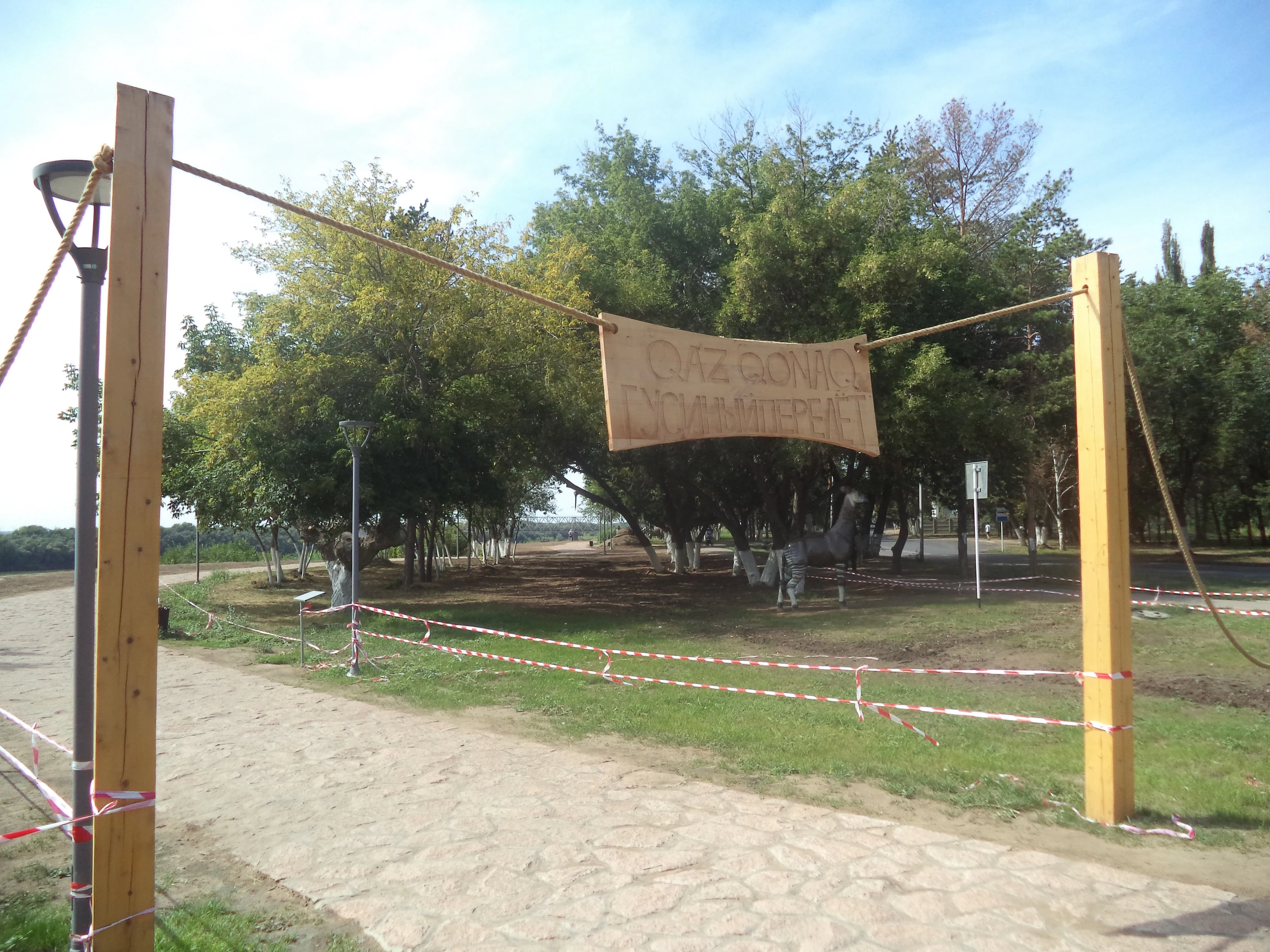
A wooden entrance gate with two tall posts and a hanging banner, with red and white caution tape blocking a dirt path leading into a wooded area.
Wooden entrance gate with a banner at the Gusiny Perelet natural monument site.

Gusiny Perelet history and protected-area timeline

Gusiny Perelet has a long history of scientific attention that precedes its formal protection by nearly a century. The geological exposure was first described in 1874 by the English naturalist Thomas Belt, who was working in Western Siberia at the time. Subsequent descriptions followed in 1886 by the geologist Nikolai Vysotsky and in 1900 by Alexander Krasnopolsky, establishing the site as a known feature of regional geological mapping long before its paleontological potential was fully appreciated.

Modern paleontological investigation of the locality began in 1928, when the paleontologist Yuri Orlov opened the site scientifically. Systematic excavations were launched in 1929 to 1930 by the Paleontological Institute of the Academy of Sciences of the USSR, with Orlov and Elizaveta Belyaeva among the principal researchers. Following the founding of the Academy of Sciences of the Kazakh SSR in 1946, investigation of the site passed increasingly into the hands of Kazakhstani scientists, exemplified by the work of the Kazakhstapan Paleozoological Team directed by Pavel Savinov in 1959.

Recognition of the site's broader importance came on 7 December 1971, when Gusiny Perelet was declared a natural monument of republican significance. Excavations after this point were only permitted under license from the Institute of Zoology of the Academy of Sciences of the Kazakh SSR. A 1979 proposal to establish an open-air museum on the site was raised jointly by the Institute of Zoology and the Central Council of the Kazakh Society for Nature Conservation but was not realized at that time. The site's status was reaffirmed in 2001 under updated legislation, and a long-awaited open-air museum was finally opened on the location in 2019, with the fossil-bearing layers simultaneously put under conservation.

Gusiny Perelet landscape and geographic character

The landscape of Gusiny Perelet is defined by the right bank of the Irtysh River as it passes through the city of Pavlodar. The monument occupies an erosional slope or ravine cut into this bank, with reported heights of roughly 15 to 20 meters above the river. Across much of its length, the exposure presents an open geological face in which layered Neogene sediments are visible, contrasting with the flatter floodplain on the opposite side of the river.

In broader geographic context, the site lies in the steppe and forest-steppe belt of northeastern Kazakhstan, a region of wide open horizons, continental climate, and large river valleys shaped by Pleistocene and Holocene processes. The Irtysh valley itself functions as both a visual marker and a natural corridor through this otherwise comparatively flat terrain. The exposure at Gusiny Perelet thus reads as a relatively small but visually striking interruption in the otherwise smooth profile of the riverside landscape, where river erosion has naturally revealed a window into the deep past.

Gusiny Perelet ecosystems, habitats, and plant life

Although it is not an ecological park in the living-habitat sense, Gusiny Perelet is a natural monument whose scientific value lies entirely in the natural record it preserves. The fossil-bearing sediments capture a vanished biological community of the Late Neogene, when the climate and vegetation of the region supported an open, savanna-like landscape with scattered woodlands and riverine corridors.

Ecologically, the site's significance is interpretive rather than contemporary: researchers use it to reconstruct the structure of the extinct Hipparion fauna community, its prey-predator relationships, and the vegetation mosaic that sustained such a diverse mammalian assemblage. The abundance of grazing and browsing herbivores alongside specialized predators indicates a productive ecosystem capable of supporting large body sizes and high biomass, even though the living flora of the surrounding territory today is steppe grassland rather than the mosaic woodland that once existed here.

Gusiny Perelet wildlife and species highlights

The vertebrate fauna preserved at Gusiny Perelet represents one of the most diverse snapshots of the Hipparion fauna known in the region, with more than 60 species documented. Among the most important taxa are the hipparionine horses themselves, which give the fauna its name. Large herbivores include Chilotherium, a hornless rhinoceros typical of Late Miocene Eurasian faunas; Sinotherium, a giant, long-horned relative of modern rhinoceroses; Samotherium, a tall giraffid; and Lagomerix, a deer-like ruminant.

Predators include Machairodus, a saber-toothed cat that occupied a high trophic niche in the assemblage. The site is also notable for its unusually diverse rodent fauna, which provides detailed evidence of smaller mammal life alongside the more charismatic megafauna. Together, these animals reflect the ecological complexity of the ancient environment and serve as a reference baseline for understanding mammalian communities of the Late Neogene across Eurasia.

Gusiny Perelet conservation status and protection priorities

As a paleontological natural monument of republican significance, Gusiny Perelet occupies a unique place in Kazakhstan's conservation framework. Its value lies not in living ecosystems but in the irreplaceability of its fossil record: an assemblage of more than 60 vertebrate species that documents a lost community of mammals from roughly 4 to 4.5 million years ago.

Since its designation as a natural monument in 1971, the site has been managed with progressively stricter controls, including excavation only by permission of the Institute of Zoology of the Academy of Sciences of the Kazakh SSR in the Soviet era, formal reaffirmation of republican status in 2001, and conservation of the fossil-bearing layers at the time of the museum's opening in 2019. These protections aim both to preserve remaining in situ fossils for ongoing research and to balance public interpretation through the open-air museum, positioning the site as a model for protecting paleontological heritage in an urban setting.

Gusiny Perelet cultural meaning and human context

Gusiny Perelet holds a meaningful place in the cultural identity of Pavlodar and in the broader landscape of paleontological heritage in Kazakhstan. The site has been intertwined with regional scientific institutions for over a century, having been studied by researchers ranging from a 19th-century English naturalist working in Western Siberia to Soviet-era paleontologists from the Academy of Sciences and later Kazakhstani scientists from the Academy of Sciences of the Kazakh SSR.

The site's establishment of an open-air museum in 2019 reflects a shift toward treating the locality not only as a research object but also as a public cultural resource. For residents of Pavlodar, the monument functions both as a link to the deep prehistory of the Irtysh valley and as a point of local pride, grounding the city's identity not solely in its industrial present but also in the ancient natural history of the surrounding landscape.

Top sights and standout views in Gusiny Perelet

Gusiny Perelet stands out as one of the richest Hipparion fauna fossil accumulations in Central Asia, with more than 60 vertebrate species from roughly 4 to 4.5 million years ago preserved in an exposed Irtysh River bank section. The site combines iconic Late Neogene mammals such as Chilotherium, Sinotherium, Samotherium, and Machairodus saber-toothed cats with an unusually rich rodent component, making it a comprehensive reference for understanding ancient mammalian communities in the region.

Equally distinctive is the site's layered institutional history, spanning more than 150 years from its first description in 1874 to its current role as a conserved natural monument and open-air museum. This combination of scientific depth, formal protection, and public interpretation places Gusiny Perelet among the most significant paleontological heritage sites in Kazakhstan.

Best time to visit Gusiny Perelet

As a fossil locality and open-air museum rather than a living ecological park, Gusiny Perelet does not have strongly seasonal character in the way an active habitat does. The exposed geological face along the Irtysh River can be visited in much of the broader warm season, when riverbank paths are accessible and outdoor museum interpretation is most comfortable. Visitors interested in clearer geological visibility may find the dry months favorable, when the contrast of the sediments and bone-bearing layers in the slope is more easily observed. Winter visits are possible but require preparation for cold continental steppe conditions along the exposed riverbank.
Monthly climate preview

Long term temperature ranges and precipitation rhythm across twelve measured months at Gusiny Perelet

Gusiny Perelet Climate Normals, Average Temperature and Monthly Precipitation Patterns

Historical climate data for Gusiny Perelet records average temperatures spanning from deep subzero winter minimums to warm summer maximums alongside measured monthly precipitation levels. Detailed monthly climate normals provide comprehensive meteorological context and facilitate granular temperature comparisons across the entire annual cycle.
Annual mean3 °C
-18 °C22 °C
Jan-18°
Feb-15°
Mar-7°
Apr
May14°
Jun21°
Jul22°
Aug20°
Sep12°
Oct
Nov-6°
Dec-14°
Warmest month
July

22.3 °C

Coolest month
January

-17.9 °C

Wettest month
July

1.6 mm/day

Driest month
January

0.5 mm/day

Park location guide

Geography guide, regional context, and park location map for Gusiny Perelet

Gusiny Perelet park geography, regions, and map view in Kazakhstan

Understand where Gusiny Perelet sits in Kazakhstan through a broader geographic reading of the surrounding landscape, nearby location context, and its mapped position within the national park landscape.

How Gusiny Perelet fits into Kazakhstan

Kazakhstan is a Central Asian country spanning vast steppes and plains, bordered by Russia, China, Kyrgyzstan, Uzbekistan, and Turkmenistan, with a coastline along the Caspian Sea. It gained independence from the Soviet Union in 1991 and has a population of approximately 20.5 million people. The country is officially secular but predominantly Muslim, with Kazakh and Russian as official languages.

Wider geography shaping Gusiny Perelet in Kazakhstan

Kazakhstan occupies a vast territory in Central Asia, extending into Eastern Europe. Its terrain consists largely of hilly plateaus and plains, with lowlands covering about a third of the area. The southern and eastern regions are mountainous. The country borders Russia to the north and west, China to the east, Kyrgyzstan to the southeast, Uzbekistan to the south, and Turkmenistan to the southwest. It has a coastline along the Caspian Sea.

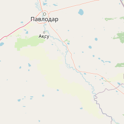
Map view of Gusiny Perelet

Use this park location map to pinpoint Gusiny Perelet in Kazakhstan, understand its exact geographic position, and read its mapped placement within the surrounding landscape more clearly.

Pigeon | © OpenStreetMap contributors

Location context for Gusiny Perelet

Pavlodar Region

Examine the terrain, exposed geological sections, and regional scenery of the protected reserve

Gusiny Perelet Photos and Landscapes: Visualizing the Protected River Bank

Visual records reveal the exposed geological layers and riverbank terrain that define the protected landscape at Gusiny Perelet. Photographic documentation helps researchers examine the physical environment and regional setting of the paleontological monument more clearly.

A wooden entrance gate with two tall posts and a hanging banner, with red and white caution tape blocking a dirt path leading into a wooded area.

Park atlas

Compare regional protected landscapes and neighboring natural monuments

Explore Protected Areas and Other Notable Parks Near Gusiny Perelet

Continue browsing regional protected areas and neighboring natural monuments after exploring Gusiny perelet. Comparative analysis of surrounding river valleys and steppe terrain broadens understanding of regional conservation networks.
A horizontal watercolor painting depicting a sparse forest in the midground and low hills in the background with a pale, misty sky.
Nature reservePavlodar Region
About 141 km away#1 closest

East

Ertis Ormany Nature Reserve: A Geographical Overview of Kazakhstan's Pine Belts

Protected forested corridors within the Kulunda Plain steppe.

Covering over 278,000 hectares, Ertis Ormany is a premier protected area in Kazakhstan's Pavlodar Region. The reserve manages unique ribbons of pine forest growing on sandy soils, forming an essential forest-steppe ecosystem that supports biodiversity and provides a natural barrier against desertification in the southwestern Kulunda Plain.

Area
2,779.61 km²
Established
2003
IUCN
VI
Relief
Lowland
National parkKazakhstan
About 177 km away#2 closest

Southwest

Bayanaul National Park: Kazakhstan's First National Park Mapped Landscape

Explore granite mountains, unique lakes, and striking rock formations.

Bayanaul National Park, situated in Kazakhstan's Pavlodar Province, represents a significant protected area renowned for its extraordinary granite mountain landscape. Established as the country's first national park, it showcases unique erosion-shaped rock formations, diverse vegetation including rare pines, and four significant freshwater lakes. This park offers a distinct visual tapestry of mountainous terrain and geological wonders within the broader Central Asian geography, making it a key destination for atlas-based discovery.

Area
684.53 km²
Established
1985
IUCN
II
Relief
Mountain
Watercolor illustration of a landscape with green forests, rolling hills, and distant mountains under a soft sky
National parkAkmola Region
About 270 km away#3 closest

West

Buiratau State National Nature Park: Kazakhstan National Park within Akmola Region

Explore unique steppe-forest transition ecosystems and geography.

Buiratau State National Nature Park in Kazakhstan's Akmola Region protects a significant transitional zone between dry steppe and semi-arid forest. This national park showcases a diverse landscape of low ridges, plains, and salt lakes, contributing to its rich biodiversity. Discover the mapped boundaries and the unique ecological character of this protected area within the context of the Kazakh Uplands atlas and its regional geography.

Area
890 km²
Established
2011
IUCN
II
Relief
Upland
A pale, soft-toned watercolor illustration of a winding stream moving through a grassy meadow with scattered trees and distant hills.
Nature reserveAbai Region
About 277 km away#4 closest

Southeast

Semey Ormany Nature Reserve: Protected Ribbon Pine Forests in Abai Region

Mapped forest corridors and steppe ecological boundaries.

Semey Ormany protects extensive ribbon pine forests that stretch through the sandy plains of the Abai Region. This reserve serves as a vital ecological buffer, bridging the gap between desert-like semi-steppes and dense woodland strips, home to diverse wildlife and rare plant communities across the Irtysh river basin.

Area
6,541.8 km²
Established
2003
IUCN
VI
Relief
Mixed relief
Watercolor illustration of a mountainous landscape with green hills, trees, and a river in the foreground
National parkKazakhstan
About 329 km away#5 closest

South

Karkaraly State National Nature Park: Kazakhstan's Mountain-Forest Protected Area

Discover unique geology, archaeology, and regional landscape context.

Delve into the distinctive protected landscape of Karkaraly State National Nature Park, situated in Kazakhstan's Karaganda Region. This park preserves a rare mountain-forest ecosystem with dramatic granite formations, ancient archaeological sites, and lakes, presenting a rich geographic contrast to the surrounding Kazakh Steppe. MoriAtlas provides structured insights into Karkaraly State National Nature Park's unique terrain, its conservation value, and its position within the broader regional geography of Central Asia.

Area
1,121.2 km²
Established
1998
IUCN
II
Relief
Mountain
Watercolor painting of a landscape with green forests, hills, and a body of water
National parkAqmola Region
About 424 km away#6 closest

West

Burabay State National Nature Park: Mapped Granite Hills and Forested Terrain Atlas

Explore protected landscapes in Kazakhstan's Aqmola Region.

Burabay State National Nature Park presents a unique protected landscape within the Kokshetau Massif of Kazakhstan's Aqmola Region. This atlas-focused entry details the park's distinctive terrain, featuring ancient granite outcrops and rolling hills draped in pine and birch forests. Understand the mapped boundaries and geographic setting of this national park, renowned for its scenic lakes and significant geological formations, offering rich context for protected-area discovery.

Area
1,299.35 km²
Established
2000
IUCN
II
Relief
Mixed relief
A pale, minimalist watercolor illustration of a soft, rolling landscape with light green and pink washes against a white background.
Wildlife reserveKaraganda Region
About 456 km away#7 closest

Southwest

Bugyly Sanctuary Wildlife Reserve and Protected Mountain Terrain in Karaganda Region

A protected zoological landscape in the heart of central Kazakhstan

Bugyly Sanctuary is a specialized wildlife reserve defined by its low mountain topography, rocky outcrops, and narrow stream-side groves. Situated in the Karaganda Region, the protected area functions as a vital refuge for argali sheep, roe deer, and various ground-nesting birds, standing as a testament to the diverse interior uplands of the Sarysu River basin.

Area
85 km²
Relief
Lowland
Water
Minor water
Watercolor illustration of a landscape with green hills, a body of water, and grassy foreground under a pink-hued sky
National parkAqmola Region
About 516 km away#8 closest

West

Kokshetau National Park: A Protected Granite Mountain and Forest-Steppe Landscape in Kazakhstan

Explore Aqmola Region's unique protected geography and mapped terrain.

Kokshetau National Park stands as a remarkable protected landscape within Kazakhstan, defined by its ancient granite mountains and its unique position as a forest-steppe island surrounded by open plains. This national park preserves a rich tapestry of boreal forests, lake-filled depressions, and geological wonders, including some of the planet's most ancient rock formations. MoriAtlas provides a structured view of Kokshetau National Park, detailing its mapped boundaries and geographic context within the Aqmola Region, offering users a deep dive into its protected area identity and ecological significance.

Area
1,821 km²
Established
1996
IUCN
II
Relief
Upland

Common questions about visiting, size, designation, and location context for Gusiny Perelet

Gusiny Perelet FAQs for park facts, access, geography, and protected area context

Find quick answers about Gusiny Perelet, including protected-area facts, park geography, trail and visitor context, and how the park fits into its surrounding country and regional landscape.
MoriAtlas Explorer

Continue Your Protected Areas Search Across the Global Atlas

Deepen your exploration by continuing the structured search for national parks and protected areas worldwide. Utilize the comprehensive filtering capabilities to compare different conservation landscapes and refine your understanding of global park geography. Discover more about the distribution and characteristics of protected natural areas.

Global natural geography