
Mori Atlas logo
Nature reserveHen and Chicken Islands

Exploring the volcanic archipelago and offshore sanctuary terrain of the Northland coastline

Hen and Chicken Islands Nature Reserve: Geographic Atlas and Protected Landscape Context

The Hen and Chicken Islands form a distinct volcanic archipelago situated twelve kilometres off the Northland Peninsula of New Zealand. This nature reserve, composed of the main island of Taranga and the smaller Marotiri chain, rises from the Pacific as a critical refuge for native forest birds and seabird populations. The rugged terrain, characterized by steep coastal ridges, craggy islets, and sheltered bays, defines the islands as a vital protected sanctuary for New Zealand biodiversity.

island archipelagovolcanic islandsuninhabited islandsbird sanctuaryImportant Bird Areaseabird colonies
A digital illustration in pastel tones showing a waterfall cascading between two pink mountains, with a forest in the foreground and a distant island across a blue sea under a pale sky with a moon.

Hen and Chicken Islands

Nature reserve

Park overview

Structured park overview, official facts, and landscape profile for Hen and Chicken Islands

Hen and Chicken Islands park facts, protected area profile, and essential visitor context

Review the core facts for Hen and Chicken Islands, including designation, size, terrain, visitor scale, habitats, and operating context in one park-focused overview.

About Hen and Chicken Islands

The Hen and Chicken Islands occupy a distinctive position among New Zealand's offshore island groups. Located east of the Northland Peninsula and visible from the mainland on clear days, they form one of the closest major island sanctuaries to the northern New Zealand coast. The chain is divided between the single large island of Taranga, or Hen Island, and a constellation of smaller islands known collectively as the Chickens or Marotiri, including Wareware, Muriwhenua, Mauitaha, Lady Alice Island (Motu Muka), Whatupuke, and Coppermine Island.

Geologically, the archipelago is a fragment of an older volcanic landscape. Hen Island itself is the eroded remnant of a roughly four-million-year-old volcano and is dominated by a rocky ridge that rises to a high point called The Pinnacles. The surrounding Chickens are smaller, more rugged landforms, some only a few hectares in extent, with steep coastlines, rocky isthmuses, and isolated stacks such as Sail Rock, which serves as a navigational landmark for yachts approaching the area. Their separation from the North Island dates to the post-glacial sea level rise after the Last Glacial Maximum, an event that transformed what were once coastal hills into a true island chain.

Ecologically, the islands represent one of the most important repositories of native fauna in northern New Zealand. Because they have remained free of many of the introduced predators that transformed mainland ecosystems, the islands harbor seabird colonies, rare forest birds, and reptile populations that have elsewhere declined or disappeared. Their protected status, shared between scenic reserve designation, wildlife refuge declaration, and co-management arrangements with Maori iwi, helps maintain this biodiversity in a region where such intact native fauna is otherwise rare.

Quick facts and research context for Hen and Chicken Islands

The Hen and Chicken Islands form an uninhabited archipelago located off the coast of Northland in northern New Zealand, lying roughly 12 kilometres east of Bream Head and about 40 kilometres south-east of Whangārei. The chain comprises nine islands in total, with Hen Island (Taranga) by far the largest and the Chickens (Marotiri) forming a smaller series of rocky islets to the north and east.

The islands are volcanic in origin, with Hen Island representing a remnant of an ancient volcanic landform that has eroded into a steep, elongated ridge. Their isolation from the mainland has made them a critical refuge for native wildlife, particularly seabirds and rare forest birds. Combined, the islands function as a scenic reserve and wildlife refuge, with formal protection extending across the entire group.

Protection and recognition

Examine the documented conservation history and official designation records.

Hen and Chicken Islands Protection Status and Designated Area History

Historical preservation records trace the protected area designation of Hen and Chicken Islands back to 1908 under a mixed protection framework. Detailed governance facts and recognition milestones outline the documented administrative scope of the reserve.

Protection details

Protection scope
Mixed
Designated year
1908
Transboundary protection
No
Park context

Deeper park guide and search-rich context for Hen and Chicken Islands

Hen and Chicken Islands history, landscape, wildlife, and travel context

Explore Hen and Chicken Islands through its history, landscape character, ecosystems, wildlife, conservation priorities, cultural context, and seasonal travel timing in a structured park guide built for atlas discovery and search intent.

Why Hen and Chicken Islands stands out

The Hen and Chicken Islands are especially known for their role as a predator-free sanctuary for New Zealand's native birdlife. The archipelago supports breeding populations of seabirds such as the Pycroft's petrel, along with forest birds that have been lost from much of the mainland. Hen Island in particular was once the last stronghold of the North Island saddleback and became a source population for translocation efforts to other sanctuary islands. Equally important is the islands' broader ecological character, which includes native reptiles such as tuatara, geckos, and skinks, and a distinctive flora that includes the puka tree. Recognized internationally as an Important Bird Area, the archipelago stands out as one of the northern New Zealand island groups where native biodiversity has persisted in conditions closer to their pre-human state.
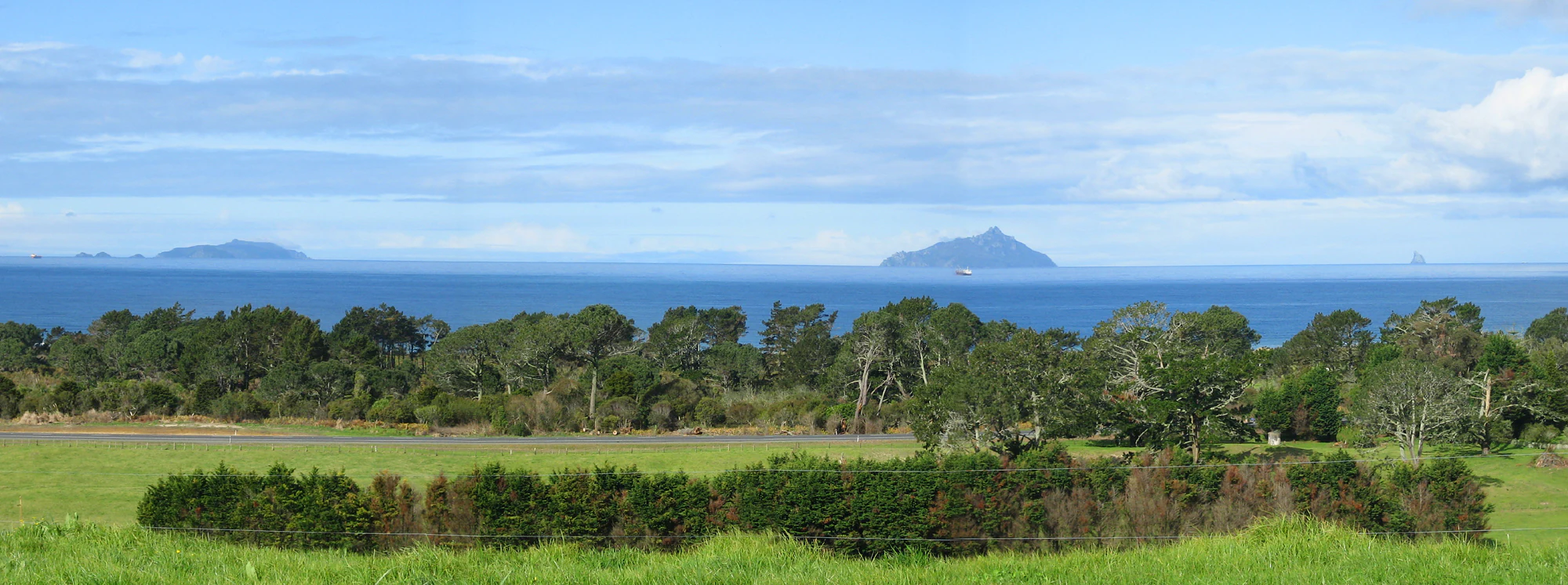
A wide landscape view of Bream Bay in New Zealand featuring green grassy fields in the foreground, a line of trees in the midground, and the Hen and Chicken Islands appearing as dark silhouettes on the horizon over the ocean.
A distant view of the Hen and Chicken Islands across Bream Bay.

Hen and Chicken Islands history and protected-area timeline

During the Last Glacial Maximum, around 18,000 years ago, the landforms that now form the Hen and Chicken Islands were hills rising above a vast coastal plain, connected to the rest of New Zealand by dry land. As sea levels rose after the glaciers began retreating, the hills were eventually cut off from the mainland, becoming the archipelago that exists today. The separation of these islands is therefore a relatively recent event in geological terms, with marine conditions similar to the present only becoming established several thousand years ago.

The islands' European name dates to Captain James Cook, who first sighted them on 25 November 1769. There is a tradition that the naming was inspired by the older European name for the Pleiades star cluster, often called the Hen and Chickens, rather than by any direct reference to poultry, though this connection remains a matter of interpretation. The islands were originally held by the Maori iwi Ngā Puhi, before being sold to the New Zealand Government in 1883. Hen Island itself had earlier passed from Maori hands when it was purchased by Thomas Outhwaite in 1872, later being bequeathed to the nation by his daughter Isa Outhwaite in 1927.

Formal protection came first in 1908, when the islands were designated as a scenic reserve in recognition of the rarity of their flora and fauna. In 1953 the chain was declared a wildlife refuge, strengthening its conservation role. The surrounding waters are also historically significant: in June 1940, the Canadian-Australasian ship RMS Niagara sank near the archipelago after striking a mine, with much of its cargo, including gold bullion, later being salvaged from the sea. Today the islands are jointly protected as a scenic reserve and wildlife refuge, with active co-management partnerships between the New Zealand Department of Conservation and Maori iwi.

Hen and Chicken Islands landscape and geographic character

The Hen and Chicken Islands are small enough to be explored largely by eye from the surrounding mainland, yet their physical character is surprisingly varied. Hen Island is long and narrow, roughly six kilometres in length but averaging less than a kilometre in width, and is dominated by a steep central ridge that culminates in The Pinnacles at around 417 metres above sea level. This ridge gives the island a distinctive spine-like silhouette visible from Bream Head and the Bream Bay coastline.

The smaller Chicken Islands present a different, more rugged terrain. Wareware and Muriwhenua are low, rocky islets, while Mauitaha rises more sharply to around 125 metres. Lady Alice Island, the largest of the Chickens, covers about 1.4 square kilometres and is surrounded by exposed rocky reefs that shape its irregular coastline. Whatupuke is steep and elongated, with coastal features such as the horseshoe-shaped Starfish Bay carved into one of its peninsulas. Coppermine Island, formed of two landmasses joined by a short isthmus, contains copper deposits that attracted nineteenth-century mining interest but yielded little.

Offshore features also contribute to the archipelago's landscape identity. Sail Rock, a sea stack standing roughly three kilometres south of Hen Island, is a particularly conspicuous landmark for vessels in the area. Together, these landforms give the chain an alternation between a dominant central ridge and a constellation of smaller, craggy islands set against the open Pacific.

Hen and Chicken Islands ecosystems, habitats, and plant life

The isolation of the Hen and Chicken Islands has shaped a distinctive natural environment. Cut off from the mainland by approximately 12 kilometres of open water and protected under successive conservation designations, the islands maintain habitats that have become rare along the adjacent Northland coast. Their vegetation reflects this isolation: forest communities and coastal scrub persist on the larger islands in patterns that contrast strongly with the heavily modified mainland.

A particularly recognizable component of the islands' flora is the puka tree, which forms a notable feature of the canopy on Hen Island and contributes to the chain's distinctive botanical character. The combination of steep topography, exposure to salt-laden winds, and freedom from browsing mammals has allowed certain plant communities to flourish here while declining elsewhere. On Lady Alice Island and the other larger Chickens, plant composition adds to the chain's ecological variety and supports the broader habitat mosaic.

The islands' habitats, ranging from Puka-dominated forest on Hen Island to coastal scrub, rocky shores, and reef-fringed coastlines around the Chickens, create a layered environment that supports both terrestrial and marine life. Their separation from the mainland has effectively preserved an ecological snapshot of pre-human Northland coastal ecosystems, making them a valuable reference point for understanding the original state of New Zealand's northern coastal environment.

Hen and Chicken Islands wildlife and species highlights

Birds are the most conspicuous and ecologically important element of the Hen and Chicken Islands' fauna. The archipelago has been formally recognized by BirdLife International as an Important Bird Area, primarily because of its breeding population of roughly 500 pairs of Pycroft's petrels. Beyond this single key species, the islands host a wider community of seabirds whose colonies persist here thanks to the absence of mammalian predators that have impacted mainland populations.

Equally significant is the chain's role in supporting New Zealand's rare forest birds. Hen Island in particular was, by the late nineteenth century, the only place in New Zealand where the North Island saddleback still survived, after the species was nearly wiped out on the mainland by introduced predators such as rats and stoats. The island became the source for later translocation efforts beginning in the 1960s, when saddleback were moved from Hen Island to predator-free sanctuaries elsewhere in New Zealand.

Reptiles add a further dimension to the islands' wildlife. Native species including tuatara, geckos, and skinks occur on the archipelago, often in populations that are genetically and ecologically significant. Conservation partnerships with Maori iwi have also explored the role of Mauitaha and nearby islands as sanctuaries for the Polynesian rat (kiore), reflecting the broader cultural and ecological significance of the islands' fauna.

Hen and Chicken Islands conservation status and protection priorities

The Hen and Chicken Islands have been the focus of formal protection for more than a century. They were first designated as a scenic reserve in 1908, primarily because of the rarity of their flora and fauna, and were subsequently declared a wildlife refuge in 1953. Together, these two designations place the entire archipelago within a framework of long-standing legal protection that has enabled native species to persist in conditions increasingly rare on the North Island mainland.

Their conservation value is both national and international in scope. BirdLife International's recognition of the islands as an Important Bird Area reflects the global importance of their seabird colonies, including the Pycroft's petrel population. At the same time, their role in safeguarding the North Island saddleback has had a continental impact, with Hen Island serving as the source population that underpinned the species' later translocation to other predator-free sanctuaries.

Modern conservation on the chain goes beyond simple protection. The New Zealand Department of Conservation has entered into partnership arrangements with Maori iwi such as Ngati Wai, who hold cultural connections to the islands, to manage specific sanctuary projects. These include co-managed initiatives on islands such as Mauitaha, where conservation strategy intersects with traditional values and with the recognition that some species long considered pests also carry cultural significance. This blend of formal reserve status, scientific recognition, and iwi partnership gives the archipelago a layered conservation profile that continues to evolve.

Hen and Chicken Islands cultural meaning and human context

The Hen and Chicken Islands carry a strong Maori cultural identity. The principal island of Taranga and the smaller Chicken group of Marotiri retain their original Maori names, anchoring the archipelago within the living geographical vocabulary of local iwi. The islands were originally held by Ngā Puhi, who exercised kaitiaki (guardianship) over them before they were sold to the New Zealand Government in 1883 following a period of change in land tenure across northern New Zealand.

Cultural engagement with the islands continues today. The iwi Ngati Wai has partnered with the Department of Conservation on active conservation projects, particularly around the management of species such as the Polynesian rat, or kiore. In these partnerships, the movement of kiore through the Pacific is understood as paralleling the migration of New Zealand Maori, embedding the islands' ecology within the wider story of Pacific voyaging and settlement rather than treating them purely as biological reserves.

The islands' European history is more recent but also visible in the landscape. Captain James Cook's naming of the archipelago in 1769 introduced a layer of European maritime culture to the place, while later Victorian-era figures such as Lady Alice Fergusson, who gave her name to the largest Chicken Island, reflect the imperial administrative culture of nineteenth-century New Zealand. Together, these Maori and European strands of history give the islands a rich cultural context that complements their ecological importance.

Top sights and standout views in Hen and Chicken Islands

A defining highlight of the Hen and Chicken Islands is their status as one of the closest major offshore island sanctuaries to the northern New Zealand mainland, making them unusually accessible in ecological terms despite lying 12 kilometres offshore. Their birdlife, ranging from seabird colonies of Pycroft's petrels to the historically important North Island saddleback population on Hen Island, positions the archipelago at the heart of New Zealand's offshore conservation story.

Equally noteworthy is the volcanic and erosional character of the islands themselves. The dominant ridge of Hen Island, the steep coastlines of Whatupuke, the isthmus-joined Coppermine Island, and the offshore stack of Sail Rock together create a landscape of striking variety at a relatively small scale. When combined with the islands' long history of protection, the cultural involvement of local iwi, and their scientific recognition as an Important Bird Area, these qualities make the archipelago a singular feature of Northland's coastal environment.

Best time to visit Hen and Chicken Islands

The Hen and Chicken Islands are uninhabited and protected, so access is restricted primarily to permitted landings managed by the New Zealand Department of Conservation. Because of this, the most practical window for viewing and appreciating the islands is from the mainland, particularly from elevated viewpoints such as Bream Head, where the entire chain is often visible across Bream Bay.

Seasonal conditions around the Northland coast are generally mild, but winter months can bring stronger winds and rougher seas, while late spring and summer typically offer calmer conditions and clearer visibility. For those interested in seabird viewing and the broader character of the islands, the warmer months tend to provide the most favourable conditions for boat-based approaches, although any visit remains governed by conservation rules rather than conventional visitor infrastructure.
Monthly climate preview

Examine long-term temperature ranges and monthly precipitation distributions across the coordinate

Hen and Chicken Islands Climate Normals and Annual Weather Patterns

Representative baseline measurements reveal an annual temperature rhythm spanning from cooler winter minimums to warmer summer maximums alongside consistent daily precipitation. Reviewing the comprehensive monthly sequence provides deeper analytical clarity regarding long-term climatic norms across the protected landscape.
Annual mean17 °C
14 °C21 °C
Jan20°
Feb21°
Mar20°
Apr18°
May17°
Jun15°
Jul14°
Aug14°
Sep14°
Oct15°
Nov16°
Dec18°
Warmest month
February

20.6 °C

Coolest month
August

13.5 °C

Wettest month
July

3.5 mm/day

Driest month
January

1.8 mm/day

Park location guide

Geography guide, regional context, and park location map for Hen and Chicken Islands

Hen and Chicken Islands park geography, regions, and map view in New Zealand

Understand where Hen and Chicken Islands sits in New Zealand through a broader geographic reading of the surrounding landscape, nearby location context, and its mapped position within the national park landscape.

How Hen and Chicken Islands fits into New Zealand

New Zealand is an island nation in the southwestern Pacific Ocean comprising two main islands and numerous smaller islands. Located east of Australia across the Tasman Sea, it features varied topography with the Southern Alps running along the South Island and volcanic terrain on the North Island. The country was settled by Maori people between 1280 and 1350, followed by European exploration beginning in 1642, and became a Dominion in 1907 before gaining full independence in 1947.

Wider geography shaping Hen and Chicken Islands in New Zealand

New Zealand lies in the southwestern Pacific Ocean, east of Australia across the Tasman Sea. The country consists of two main islands, the North Island and South Island, plus over 600 smaller islands. The North Island features volcanic plateaus and hills while the South Island is dominated by the Southern Alps mountain range. The country has a long coastline and is surrounded by the Pacific Ocean.

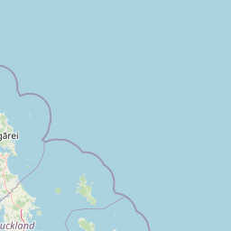
Map view of Hen and Chicken Islands

Use this park location map to pinpoint Hen and Chicken Islands in New Zealand, understand its exact geographic position, and read its mapped placement within the surrounding landscape more clearly.

Pigeon | © OpenStreetMap contributors

Visual reference collection showcasing the rugged ridges, sea stacks, and protected sanctuary landscapes of the archipelago.

Hen and Chicken Islands Photos: Scenery, Volcanic Terrain, and Island Habitats

Visual documentation of Hen and Chicken Islands reveals the steep volcanic ridges, craggy offshore islets, and dense native forest habitats that define the archipelago. Examining these protected landscapes helps clarify the physical character, coastal topography, and ecological sanctuary status of the offshore reserve.

A wide landscape view of Bream Bay in New Zealand featuring green grassy fields in the foreground, a line of trees in the midground, and the Hen and Chicken Islands appearing as dark silhouettes on the horizon over the ocean.

Distant islands visible on the horizon across a body of water at sunset, with coastal scrub vegetation in the foreground.

Park atlas

Compare adjacent coastal reserves and offshore sanctuaries across the regional terrain

Other Parks Near Hen and Chicken Islands and Surrounding Protected Landscapes

Browsing other parks near Hen and Chicken Islands reveals connected coastal ecosystems and offshore wildlife sanctuaries across the surrounding region. Comparing these protected landscapes provides valuable geographical context for New Zealand insular conservation networks.
Regional parkAuckland Region
About 23 km away#1 closest

South

Te Ārai Regional Park: Mapping Coastal Dune Systems and Protected Geography in Auckland

A protected coastal landscape featuring expansive dune systems and northern headlands.

Te Ārai Regional Park sits as a major protected coastal area on the northern edge of the Auckland Region. Its primary defining feature is an expansive system of sand dunes that anchor a diverse coastal environment. Extending southward toward Poutawa Stream and bordered by the Mangawhai Forest, the park represents a critical geography for endangered species breeding and provides a distinct topographic profile along the North Island coast.

Established
2008
Relief
Lowland
Climate
Subtropical
Access
Easy access
A watercolor painting showing a soft, bright landscape with green grasses and wildflowers on both sides of a calm, pale blue body of water, with a green coastline in the distance.
Marine protected areaNew Zealand
About 36 km away#2 closest

South

Cape Rodney-Okakari Point Marine Reserve: New Zealand Marine Protected Area Geography

Mapped coastal boundaries and marine ecosystem terrain

Delve into the geography of Cape Rodney-Okakari Point Marine Reserve, where protected waters meet a complex interface of greywacke bedrock and sandy substrates. This assessment highlights the ecological transition from exposed rocky headlands to sheltered Whangateau Harbour, illustrating the structural depth of New Zealand's foundational marine site through its diverse invertebrate and fish habitats.

Area
5.5 km²
Established
1975
IUCN
Ia
Visitors
200K annual
A pale, minimalist watercolor painting depicting soft green and pink hilly island silhouettes rising from a calm, white-toned sea.
Marine protected areaNew Zealand
About 40 km away#3 closest

North

Poor Knights Islands Marine Reserve: Geography and Marine Protected Area Atlas

Exploring coastal cliffs and underwater volcanic terrain

The Poor Knights Islands Marine Reserve encompasses a protected 1,890 hectare marine environment renowned for its steep underwater walls and tunnel systems. Located off the coast of New Zealand, this reserve serves as a critical study area for marine conservation and ecosystem recovery. Explore the geological features, including the Northern Arch and rugged offshore rock stacks, which distinguish this maritime landscape.

Area
18.9 km²
Established
1981
Access
Access unknown
Scope
Marine
Nature reserveNorthland Region
About 48 km away#4 closest

North

Poor Knights Islands Nature Reserve: Mapped Volcanic Geography and Protected Coastal Landscapes

A rugged island chain offshore from New Zealand's Northland Region.

The Poor Knights Islands serve as an essential protected landscape characterized by sheer volcanic cliffs, natural arches, and extensive sea cave systems. Rising sharply from the sea, these uninhabited islands function as a vital sanctuary for seabirds and native flora, providing a unique look into the deeply eroded remnants of ancient rhyolitic volcanic activity within New Zealand.

Area
2.714 km²
Established
1975
IUCN
Ia
Relief
Upland
Nature reserveNew Zealand
About 56 km away#5 closest

Northwest

Waro Limestone Scenic Reserve: Karst Landscapes and Cultural Heritage in Northland, New Zealand

A study in geological formations and industrial history.

Waro Limestone Scenic Reserve offers a concentrated look at Northland geography, featuring vertical limestone outcrops and a flooded quarry set within rural farmland. As a protected nature reserve, it serves as a site of significant Māori cultural heritage while also preserving remnants of early New Zealand industrial activity, such as coal mining and lime extraction, which shaped the surrounding terrain.

Relief
Upland
Climate
Subtropical
Scope
Terrestrial
Water
Minor water
A soft watercolor illustration showing the low-lying shape of Motuora Island surrounded by calm water, with a distant hilly coastline in the background.
Nature reserveNorth Island
About 64 km away#6 closest

South

Motuora Nature Reserve: Protected Coastal Island Geography and Restoration Map

Predator-free ecological sanctuary in the Hauraki Gulf

Motuora occupies a key position in the Hauraki Gulf, offering a well-mapped look at coastal island restoration in New Zealand. This protected area features a regenerated forest interior and cliff-edged terrain, serving as an important mainland-island site for avian conservation, including kiwi and petrel colonies.

Area
0.8 km²
Established
1965
Relief
Lowland
Climate
Subtropical
Regional parkAuckland Region
About 64 km away#7 closest

South

Te Muri Regional Park: Mapped Coastal Peninsula and Estuarine Geography in Auckland

Protected native forest and tidal estuary landscapes

Te Muri Regional Park presents a unique peninsular landscape situated between the Puhoi River and Te Muri O Tarariki Stream in Auckland. This protected area showcases a complex interface between native coastal forest and tidal ecosystems, offering clear mapped boundaries that connect to the wider Hauraki Gulf coastal belt. Explore the topographical transition from sea level estuaries to rolling hill country.

Area
4.44 km²
Established
2010
Relief
Upland
Scope
Terrestrial
Regional parkAuckland Region
About 66 km away#8 closest

South

Wenderholm Regional Park: Coastal Forest and Estuary Geography in the Auckland Region

Mapped protected landscapes of a coastal New Zealand peninsula

Situated on a narrow peninsula north of Auckland, Wenderholm Regional Park offers a compact study in diverse coastal terrain. The park encompasses the forested Maungatauhoro headland, the tidal Puhoi sandspit, and riverine boundaries that create a distinct protected environment. Since its 1965 founding, the area has become a haven for native bird restoration and coastal vegetation, providing a unique vantage point across the Hauraki Gulf.

Area
1.35 km²
Established
1965
Relief
Mixed relief
Climate
Temperate

Common questions about visiting, size, designation, and location context for Hen and Chicken Islands

Hen and Chicken Islands FAQs for park facts, access, geography, and protected area context

Find quick answers about Hen and Chicken Islands, including protected-area facts, park geography, trail and visitor context, and how the park fits into its surrounding country and regional landscape.
MoriAtlas Explorer

Continue Your Protected Areas Search Across the Global Atlas

Deepen your exploration by continuing the structured search for national parks and protected areas worldwide. Utilize the comprehensive filtering capabilities to compare different conservation landscapes and refine your understanding of global park geography. Discover more about the distribution and characteristics of protected natural areas.

Global natural geography