
Mori Atlas logo
Nature reserveHohe Wand Nature Park

Mapping the dramatic cliff edges and transitional terrain of this regional nature reserve

Hohe Wand Nature Park: A Protected Limestone Plateau and Alpine Landscape in Lower Austria

(Naturpark Hohe Wand)

Hohe Wand Nature Park stands as a defining protected landscape within the Gutenstein Alps, where a wooded limestone plateau meets the Vienna Basin. This area marks a significant ecological boundary between Alpine terrain and the Pannonian Plain, characterized by expansive cliff faces and karst cave systems. Through its unique position, the park illustrates the complex geology and regional biodiversity of Lower Austria.

nature parklimestone plateauAlpine-Pannonian transitioncliffscavesGutenstein Alps
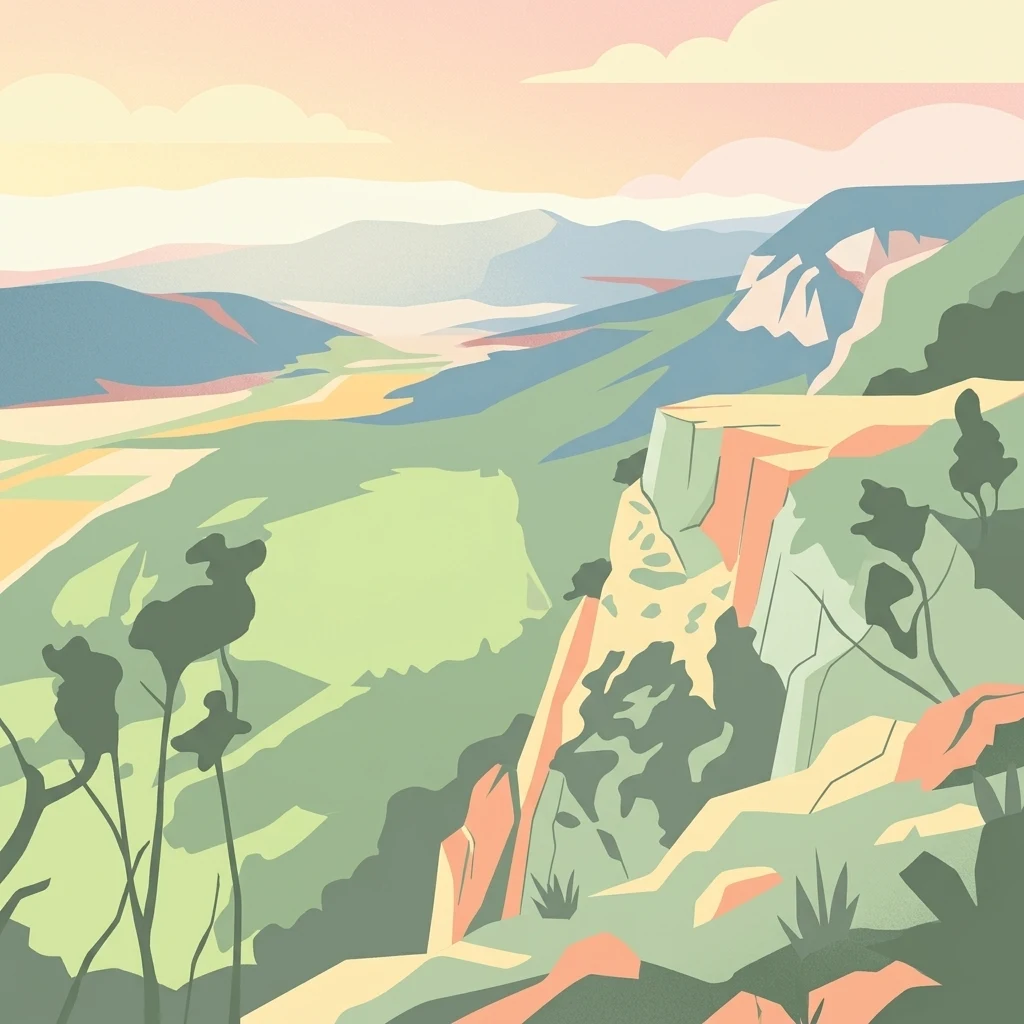
A stylized digital illustration of a mountainous landscape at sunset, featuring prominent steep limestone cliffs in the foreground and a vast valley extending into the distance under a warm-toned sky.

Hohe Wand Nature Park

Nature reserve

Park overview

Structured park overview, official facts, and landscape profile for Hohe Wand Nature Park

Hohe Wand Nature Park park facts, protected area profile, and essential visitor context

Review the core facts for Hohe Wand Nature Park, including designation, size, terrain, visitor scale, habitats, and operating context in one park-focused overview.

About Hohe Wand Nature Park

Hohe Wand Nature Park covers an area of limestone plateau, cliff, and forest at the eastern margin of the Austrian Alps. It is positioned at a key ecological crossroads: the wooded mountain faces of the Gutenstein Alps on one side, and the warmer, drier influences of the Pannonian region on the other. This transitional geography gives the park its distinctive identity, with habitats and species from both worlds meeting within a relatively compact area.

The bedrock of the park is limestone, which has weathered into karst features, including a number of caves both large and small. Notable examples include the Cserny Cave near the Felsenpfad cliff path and the Unicorn Cave near Dreistetten, a show cave that draws visitors interested in underground geology.

The plateau and its surroundings have long served as a local recreation area. A public road up to the plateau was hewn from the rock in the 1930s, and a chairlift that once served visitors has since been closed. The modern visitor infrastructure blends nature-oriented family attractions with classic alpine outdoor amenities: a nature playground, a petting zoo and small wild-animal enclosure, an observation tower with a climbable giant marmot structure, an alpine and local history museum, and a dense network of marked hiking trails, secured via ferrata routes, open climbing terrain, and hang gliding and paragliding launch sites.

For visitors seeking orientation, the cliff-edge Skywalk, installed in 2002, is one of the park's signature features, perched along the upper Wand edge overlooking the southeastern drop. The area's accessibility from the Vienna metropolitan region, combined with its ecological importance as part of the European Northeastern Perimeter Alps protected area, makes it a significant node for both conservation and outdoor recreation in Lower Austria.

Quick facts and research context for Hohe Wand Nature Park

Hohe Wand Nature Park lies in the Gutenstein Alps of Lower Austria, straddling the municipalities of Wöllersdorf-Steinabrückl, Bad Fischau-Brunn, Hohe Wand, and Höflein an der Hohen Wand. Its geology is dominated by limestone, and it marks the eastern edge of the Alps where they descend toward the Pannonian Plain and the Vienna Basin.

The park's protected designations include its status as an Austrian nature park, its inclusion in the European protected area known as the Northeastern Perimeter Alps, and its overlap with the Hohe Wand-Dürre Wand Nature Reserve. Plateau elevations host wooded habitats and cliffs, with a deep trail network, secured via ferrata routes, caves such as the Unicorn Cave near Dreistetten, and a major observation platform called the Skywalk erected in 2002.

Protection and recognition

Examine documented conservation boundaries, management designations, and international recognition records.

Hohe Wand Nature Park Protection Status and Designated Terrestrial Scope

Terrestrial conservation framing outlines the documented protection status and management scope established for Hohe Wand Nature Park. Official designation records detail international recognition parameters and administrative frameworks associated with the protected landscape.

Protection details

Protection scope
Terrestrial
Transboundary protection
No
Park context

Deeper park guide and search-rich context for Hohe Wand Nature Park

Hohe Wand Nature Park history, landscape, wildlife, and travel context

Explore Hohe Wand Nature Park through its history, landscape character, ecosystems, wildlife, conservation priorities, cultural context, and seasonal travel timing in a structured park guide built for atlas discovery and search intent.

Why Hohe Wand Nature Park stands out

Hohe Wand Nature Park is best known for being a textbook example of an Alpine-to-Pannonian ecological transition, where alpine woodland and rocky steppe flora and fauna coexist on a single limestone plateau. Its dramatic southeastern cliffs, dropping roughly 230 metres toward the so-called New World (Neue Welt) below, give the area its defining visual character and connect the high plateau landscape with the warmer lowlands beyond. The park is also known for the Skywalk observation terrace at the upper Wand edge, offering panoramic views across the transition zone. The combination of limestone caves, exposed cliff habitat, climbing terrain, and paragliding launch sites has made it a focal point for outdoor recreation and nature interpretation in the region south of Vienna.
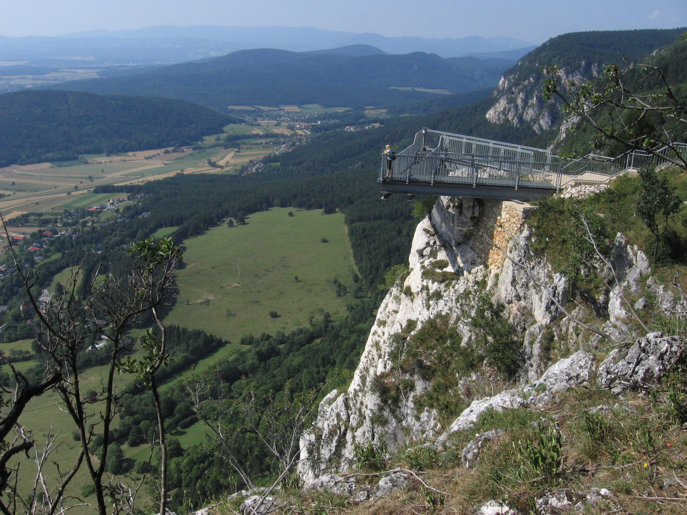
A metal observation platform, the Skywalk, extending out from a steep limestone cliff with a wide view over a valley and forest below.
The Skywalk observation platform extending over the limestone cliffs of Hohe Wand Nature Park.

Hohe Wand Nature Park history and protected-area timeline

Human use of the Hohe Wand plateau stretches back through generations of local activity in industry, farming, and later tourism, but the area's identity as a nature park developed as part of Austria's broader tradition of recognizing and protecting its most scenic and ecologically meaningful landscapes.

A pivotal moment in the area's accessible history came in the 1930s, when a public road was hewn out of the rock to reach the plateau, opening it to visitors in a structured way. A chairlift subsequently served the area, though it has since been closed. The Skywalk observation terrace was erected in 2002 along the upper edge of the Wand, marking a more recent investment in viewing infrastructure. Hohe Wand Nature Park also participates in larger conservation frameworks, including the European Northeastern Perimeter Alps protected area and the Hohe Wand-Dürre Wand Nature Reserve, situating it within wider regional efforts to manage transitional Alpine landscapes.

Hohe Wand Nature Park landscape and geographic character

Hohe Wand is fundamentally a limestone plateau mountain shaped by the geological boundary between the Alps and the Pannonian lowlands. The plateau itself is wooded, and its southeastern face breaks into cliffs that drop in places by as much as roughly 230 metres, exposed toward the area historically known as the Neue Welt, or New World.

The bedrock is limestone, which has produced karst features, weathered cliff faces, and a network of both large and small caves. From the open rim of the plateau, visitors gain sweeping vistas over the transition into the Vienna Basin and the broader Pannonian landscape beyond. Inside the plateau environment, trails wind through forested terrain, while the cliff edge provides dramatic viewpoints such as the Skywalk and the Felsenpfad cliff path.
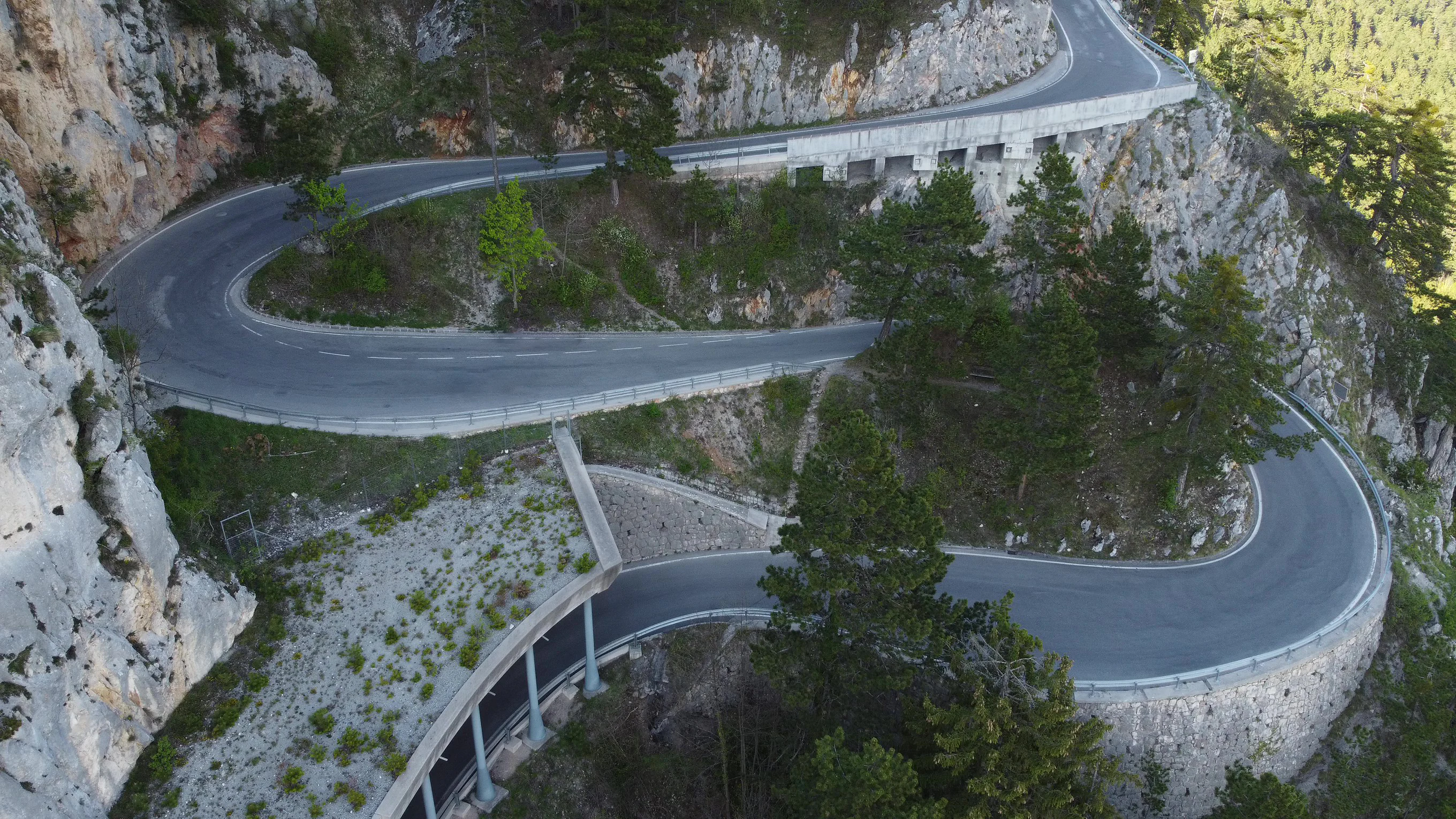
An aerial view of a narrow, winding road with multiple hairpin turns carved into steep, pale limestone mountain cliffs, with sparse trees along the roadside.
The winding toll road leading up the limestone cliffs of Hohe Wand Nature Park.

Hohe Wand Nature Park ecosystems, habitats, and plant life

Ecologically, Hohe Wand lies at one of Austria's most significant biogeographical interfaces. The plateau and its surroundings sit in the transition zone between alpine mountain environments and the warmer, drier Pannonian steppe, and this overlapping influence shapes both its flora and fauna. Species typical of forested alpine ridges meet those associated with rocky steppe habitats, producing a habitat mosaic of unusual richness for such a compact area.

Vegetative cover includes wooded slopes on the plateau, alongside exposed cliff vegetation on the southeastern faces. The limestone bedrock supports a variety of microhabitats, from shaded rock crevices to drier cliff-edge communities. Below the cliffs, the warmer microclimate of the Neue Welt adds further diversity, contributing to the gradient that defines the entire nature park.

Hohe Wand Nature Park wildlife and species highlights

Because Hohe Wand sits at the meeting point of alpine and Pannonian biomes, its wildlife reflects influences from both worlds. The forest and cliff habitats of the plateau support typical alpine and sub-alpine species, while the warmer, rockier southeastern faces and the lower slopes harbor species more commonly associated with Pannonian steppe and rocky steppe environments.

The park maintains a small wild animal enclosure on the plateau as part of its family-friendly facilities, providing visitors with opportunities to observe species such as marmots, which mirror the alpine wildlife theme of the surrounding landscape. Beyond this managed exhibit, the cliffs and forests are home to the natural fauna expected of an Alpine-Pannonian transition zone, with birds of prey and other cliff-nesting species particularly associated with the high southeastern rock faces.

Hohe Wand Nature Park conservation status and protection priorities

The conservation significance of Hohe Wand Nature Park lies primarily in its function as a protected transition zone between two major European biogeographical regions. Its designation as an Austrian nature park acknowledges both its scenic character and its ecological value, while its inclusion in the European protected area known as the Northeastern Perimeter Alps connects it to a wider, trans-boundary network aimed at conserving Alpine margin landscapes.

Additional protection comes through its overlap with the Hohe Wand-Dürre Wand Nature Reserve. Collectively, these designations frame the park as a key node for the conservation of limestone plateau woodland, cliff ecosystems, and the species that depend on the meeting of alpine and Pannonian habitats.

Hohe Wand Nature Park cultural meaning and human context

Although the park is primarily defined by its natural environment, the Hohe Wand plateau carries a clear cultural dimension tied to local Alpine heritage. The presence of an alpine and local history museum on the plateau reflects the area's traditional connection with regional identity and mountain culture, while long-standing visitor infrastructure, including a 1930s access road and a now-closed chairlift, signals the plateau's long history as a local recreation area.

Names such as the Neue Welt, or New World, applied to the landscapes below the cliffs, hint at older regional place-name traditions that frame the area as a threshold between mountain and lowland. The park's blend of nature-based family attractions, guided woodland tours, and adventure activities also illustrates how contemporary Austrian nature parks integrate nature interpretation with regional cultural storytelling.

Top sights and standout views in Hohe Wand Nature Park

The defining highlights of Hohe Wand Nature Park are its limestone cliffs rising up to roughly 230 metres along the southeastern edge of the plateau, the Skywalk observation terrace installed in 2002 at the upper Wand rim, and the ecological interest of an Alpine-Pannonian transition zone. These features combine to give the park a strong visual and scientific identity within the Gutenstein Alps.

Equally important are the area's network of caves, including the Unicorn Cave near Dreistetten, and its dense outdoor recreation infrastructure, with marked hiking trails, secured via ferrata routes, climbing terrain, and hang gliding and paragliding launch sites. Family-oriented nature attractions, including a nature playground, petting zoo, observation tower, and a climbable giant marmot, add a distinctive educational layer. The park's easy accessibility from the Vienna region, alongside its role within the European Northeastern Perimeter Alps protected area, reinforces its value as a destination for both conservation-minded visitors and outdoor recreation.

Best time to visit Hohe Wand Nature Park

Because the Hohe Wand plateau and cliffs sit at the Alpine-Pannonian interface, the character of a visit changes meaningfully with the seasons. Spring and early summer are well-suited to experiencing the transitional vegetation of the plateau, with cooler alpine air meeting the warmer exposures of the cliff face, and to enjoying the network of marked hiking trails, via ferrata routes, and climbing terrain under generally favorable conditions.

Late summer and early autumn bring stable weather that is often favored for hang gliding and paragliding launches from the cliff edges, as well as for clearer panoramic views from the Skywalk and surrounding viewpoints. Winter brings its own appeal, with snow on the plateau and cliffs transforming the limestone landscape, though conditions in the colder months make some adventure-focused facilities and airspace activities less suitable.

Monthly climate preview

Long-term temperature and precipitation records measured at a representative coordinate

Hohe Wand Nature Park Climate Normals and Annual Weather Patterns

Representative coordinate records show average monthly temperatures ranging from sub-zero winter minimums to warm summer maximums alongside consistent daily precipitation. Reviewing twelve-month averages provides precise historical baseline data for understanding annual meteorological conditions across the park landscape.
Annual mean9 °C
-2 °C21 °C
Jan-2°
Feb
Mar
Apr
May14°
Jun19°
Jul21°
Aug20°
Sep15°
Oct
Nov
Dec-1°
Warmest month
July

20.6 °C

Coolest month
January

-1.8 °C

Wettest month
June

2.9 mm/day

Driest month
January

1.2 mm/day

Park location guide

Geography guide, regional context, and park location map for Hohe Wand Nature Park

Hohe Wand Nature Park park geography, regions, and map view in Austria

Understand where Hohe Wand Nature Park sits in Austria through a broader geographic reading of the surrounding landscape, nearby location context, and its mapped position within the national park landscape.

How Hohe Wand Nature Park fits into Austria

Austria is a landlocked country in Central Europe, bordered by Germany, Czech Republic, Slovakia, Hungary, Slovenia, Italy, Switzerland, and Liechtenstein. The country is a federal semi-presessional republic composed of nine states, with Vienna as its capital and largest city. It has a population of approximately 9.1 million people.

Wider geography shaping Hohe Wand Nature Park in Austria

Austria is located in Central Europe, lying in the Eastern Alps. It is bordered by Germany and Czech Republic to the north, Slovakia to the northeast, Hungary to the east, Slovenia and Italy to the south, and Switzerland and Liechtenstein to the west.

Map view of Hohe Wand Nature Park

Use this park location map to pinpoint Hohe Wand Nature Park in Austria, understand its exact geographic position, and read its mapped placement within the surrounding landscape more clearly.

Pigeon | © OpenStreetMap contributors

Location context for Hohe Wand Nature Park

Lower Austria

Explore high-resolution park imagery capturing the landscape character, rugged terrain, and transitional habitats of Lower Austria.

Hohe Wand Nature Park Photos and Scenery: Visualizing the Limestone Plateau and Alpine Cliffs

Visual documentation of Hohe Wand Nature Park reveals the dramatic limestone cliffs, wooded plateaus, and sweeping vistas that define the regional protected environment. Studying these landscape views helps researchers and visitors interpret the unique ecological transition zone between the Alps and the Pannonian Plain.

A metal observation platform, the Skywalk, extending out from a steep limestone cliff with a wide view over a valley and forest below.

A cantilevered metal observation deck extending over a steep limestone cliff with a wide view of the valley below.

An aerial view of a narrow, winding road with multiple hairpin turns carved into steep, pale limestone mountain cliffs, with sparse trees along the roadside.

Park atlas

Compare regional alpine terrain and adjacent protected areas in Lower Austria

Other Parks Near Hohe Wand Nature Park and Surrounding Protected Landscapes

Browsing other parks near Hohe Wand Nature Park reveals a diverse network of protected limestone landscapes and alpine transition zones across the surrounding region. Comparing adjacent mountain terrain and valley reserves helps place individual protected areas into a broader regional geographical context.
Protected landscapeLower Austria
About 30 km away#1 closest

North

Vienna Woods: Protected Landscape, Forested Highlands, and Alpine Foothill Geography

Natural terrain and protected boundaries in Lower Austria

The Vienna Woods encompass a distinct geographic region where sandstone ridges meet limestone formations. This protected landscape provides a dense network of forest habitats, river gorges, and significant peaks overlooking the Danube. Its structure traces the edge of the Alps, offering a rich study in regional geology, elevation gradients, and the intersection of natural wilderness with the surrounding basin environment.

Area
1,056.45 km²
Established
1987
Relief
Mountain
Climate
Temperate
Watercolor illustration of a landscape with green hills, a body of water, and trees under a soft sky
National parkGyőr-Moson-Sopron
About 45 km away#2 closest

East

Fertő-Hanság National Park: Central European Wetland and Salt Lake Protected Area

Mapped Geographic Boundaries and Landscape Context

Fertő-Hanság National Park, situated in Győr-Moson-Sopron, Hungary, is a vital protected landscape renowned for its shallow salt lake and expansive marshlands. This page provides an atlas-focused discovery of its protected area, highlighting the unique interplay of reed beds and alkaline grasslands. Understand the park's geographic setting and its role as a significant wetland ecosystem for bird populations and specialized flora.

Area
235.88 km²
Established
1991
IUCN
II
Relief
Lowland
National parkLower Austria
About 49 km away#3 closest

Northeast

Danube-Auen National Park: Protected Floodplain Ecosystem and Regional Geography

Mapped boundaries and vital riparian landscape in Lower Austria.

Delve into the unique protected landscape of Danube-Auen National Park, a cornerstone of Central European riparian conservation. This page offers detailed insights into its mapped boundaries, the dynamic interplay of river channels, lowland forests, and wetlands, and its significant role within the geographic context of Lower Austria. Understand the atlas value of this protected area, ideal for discovering rich natural terrain and ecosystem context.

Area
93 km²
Established
1996
IUCN
II
Relief
Lowland
Watercolor painting showing a landscape with rolling terrain, water features, and distant mountains
National parkBurgenland
About 51 km away#4 closest

East

Neusiedler See-Seewinkel National Park: Protected Steppe Lake Landscape in Burgenland

Explore mapped wetland geography and birdwatching significance.

Neusiedler See-Seewinkel National Park showcases a rare steppe lake environment and extensive wetland habitats at the eastern edge of Austria, within the Burgenland region. This protected area is globally recognized for its exceptional avian diversity and the unique ecological mosaic formed by reed beds, salt marshes, and seasonal pools. Explore its mapped boundaries and distinctive Pannonian geography for a deep understanding of this vital European protected landscape.

Area
97 km²
Established
1993
IUCN
II
Relief
Lowland
A horizontal watercolor illustration depicting a quiet riverbank with soft green trees, light vegetation, and calm water reflecting the landscape.
Nature reserveVienna
About 52 km away#5 closest

Northeast

Lobau Nature Reserve: Mapping the Protected Danube Floodplain Landscapes of Vienna

Riparian forests, oxbow lakes, and historic wetland ecosystems.

Lobau preserves the ecological memory of the Danube through a landscape of slow-moving water bodies and dense forest stands. Situated within Vienna, this protected area features a distinct topography of dry gravel terraces, reedy ponds, and riparian corridors, offering significant insights into the region's natural history and riverine geography.

Area
22 km²
Established
1905
Relief
Lowland
Climate
Temperate
Watercolor painting of a shallow lake scene with green reeds in the foreground, small trees on the shoreline, and rolling hills in the soft, hazy background.
Nature reserveAustria
About 53 km away#6 closest

East

Lake Neusiedl: Protected Nature Reserve and Pannonian Steppe Geography in Austria

An endorheic lake system and critical wetland sanctuary.

Lake Neusiedl is a distinct nature reserve representing a rare European steppe lake environment. Its geography includes a vast ring of Phragmites reed beds, saline wetlands, and surrounding lowlands that form a vital migratory corridor. The lake serves as a cornerstone for protected landscapes in Austria, blending natural marshland dynamics with a deeply storied cultural history.

Area
315 km²
Established
1993
Relief
Lowland
Climate
Temperate
A horizontal watercolor painting showing a meandering river flowing through a lush green valley with light pink reeds in the foreground.
Protected areaAustria
About 54 km away#7 closest

South

Lafnitztal Protected Area: River Valley Geography and Floodplain Landscapes

A preserved riparian corridor in southeastern Austria

The Lafnitztal protected area serves as a primary reference site for riverine conservation in Austria. It features a complex network of meandering river reaches, alluvial forests, and moorgrass meadows that bridge the gap between the Eastern Alps and the Pannonian basin, creating a unique study of Central European lowland geography.

Established
2002
Relief
Mixed relief
Climate
Temperate
Scope
Terrestrial
Watercolor painting of a rolling hilly landscape with green slopes, sparse trees, and a winding path in the foreground.
Nature reserveLower Austria
About 74 km away#8 closest

Northeast

Hundsheimer Berg Nature Reserve: Protected Landscapes of the Lower Austrian Carpathians

Mapped dry steppe, karst topography, and pannonian forest habitats

Rising abruptly from the Danube lowlands, Hundsheimer Berg preserves a compact range of crystalline and limestone hills. This nature reserve provides vital insights into the pannonian biogeographic region, featuring a diverse mosaic of rocky slopes and dry grasslands that support a high concentration of rare insects and plants.

Area
1.66 km²
Established
1965
IUCN
IV
Relief
Mountain

Common questions about visiting, size, designation, and location context for Hohe Wand Nature Park

Hohe Wand Nature Park FAQs for park facts, access, geography, and protected area context

Find quick answers about Hohe Wand Nature Park, including protected-area facts, park geography, trail and visitor context, and how the park fits into its surrounding country and regional landscape.
MoriAtlas Explorer

Continue Your Protected Areas Search Across the Global Atlas

Deepen your exploration by continuing the structured search for national parks and protected areas worldwide. Utilize the comprehensive filtering capabilities to compare different conservation landscapes and refine your understanding of global park geography. Discover more about the distribution and characteristics of protected natural areas.

Global natural geography