
Mori Atlas logo
Nature reserveHollenloch

Examining the subterranean cave systems and ancient limestone forest habitats of the Sauerland region

Hollenloch Nature Reserve: Karst Geography and Protected Landscapes in North Rhine-Westphalia

(Naturschutzgebiet Hollenloch / Ziegentempel)

Hollenloch serves as a critical nature reserve defined by its extensive Upper Devonian reef limestone geology. The area preserves a complex system of deep, mapped cave passages alongside surface karst morphology and rare beech woodland habitats on shallow calcareous soils. This protected landscape functions as a vital hibernation site for multiple bat species while maintaining significant archaeological importance within the Sauerland region.

cavekarst landscapestalactite cavelimestone beech forestbeecheslimestone cliffs
An illustration of a green meadow with yellow and pink wildflowers behind a wooden fence, with a cluster of trees and a distant waterfall under a cloudy sky.

Hollenloch

Nature reserve

Park overview

Structured park overview, official facts, and landscape profile for Hollenloch

Hollenloch park facts, protected area profile, and essential visitor context

Review the core facts for Hollenloch, including designation, size, terrain, visitor scale, habitats, and operating context in one park-focused overview.

About Hollenloch

Hollenloch is a karst cave system and its surrounding protected woodland in the upper Sauerland of North Rhine-Westphalia, in western Germany. It is situated west of the village of Brilon-Rösenbeck, in the Hochsauerland district, and lies within the geological zone of the Brilon Massenkalk, an Upper Devonian reef limestone that has been shaped by dissolution over millions of years into a network of caves, fissures, and collapse features.

With a documented passage length of more than 2,700 meters and a vertical extent of about 92 meters, Hollenloch is counted among the longest and deepest caves known in the Sauerland region. The cave owes its existence to the chemical weathering of this calcareous bedrock, and its interior contains notable speleothem formations, including the visually striking Apostelhalle, or Apostles' Hall. As a show cave, the site has never been commercially developed: instead, the entrance has been locked since 1960 to safeguard the cave from vandalism and uncontrolled access.

Above ground, the Hollenloch / Ziegentempel nature reserve protects the karst landscape that surrounds the cave entrance, including a related karst feature called the Schwalgloch and a network of limestone cliffs. The vegetation is dominated by a species-rich limestone beech forest rooted in shallow, rocky soils that are characteristic of calcareous uplands. The combination of intact beech forest on carbonatic substrate and concealed subterranean habitats gives the site a layered ecological character unusual within the broader forested Sauerland.

The cave also carries a strong human and archaeological dimension. Bone finds from cave bears and cave hyenas show that the entrance was used by ice age animals, while artifacts such as flint arrowheads, scrapers, blades, ceramic fragments, and Iron Age ornaments document human use from at least the Neolithic onward. The layered identity of Hollenloch, as a geological, ecological, archaeological, and cultural site, lies at the center of why it is protected under both national nature reserve law and the European Habitats Directive.

Quick facts and research context for Hollenloch

Hollenloch lies in the Hochsauerland district of North Rhine-Westphalia, west of the village of Brilon-Rösenbeck, within the Upper Devonian Brilon reef limestone. The cave has a known passage length of more than 2,700 meters and a depth of 92 meters, making it one of the longest and deepest caves documented in the Sauerland.

The site is officially designated as the nature reserve Hollenloch / Ziegentempel, covering around 3.2 hectares, and simultaneously as the FFH area Rösenbecker Höhle under the EU Habitats Directive. The cave entrance lies within a beech forest rooted in calcareous rock, and the protected area includes the Schwalgloch, a related karst collapse feature. Cave access has been locked since 1960 to protect the site from vandalism.

Protection and recognition

Documented establishment history, management scope, and recognition data for Hollenloch

Hollenloch Protection Status and Terrestrial Conservation Designation Records

Terrestrial conservation records for Hollenloch outline the official designation established in the year 2001. Structured protection data details the administrative scope and international recognition status associated with the terrain.

Protection details

Protection scope
Terrestrial
Designated year
2001
Transboundary protection
No
Park context

Deeper park guide and search-rich context for Hollenloch

Hollenloch history, landscape, wildlife, and travel context

Explore Hollenloch through its history, landscape character, ecosystems, wildlife, conservation priorities, cultural context, and seasonal travel timing in a structured park guide built for atlas discovery and search intent.

Why Hollenloch stands out

Hollenloch is best known as one of the longest and deepest caves of the German Sauerland, developed in Devonian reef limestone and notable for its impressive stalactite formations such as the Apostelhalle. The cave is also recognized for its paleontological record, including bones of cave bears and cave hyenas recovered from its sediments. Just as important is its role as a bat wintering site, where seven bat species have been documented, including the rare pond bat, Natterer's bat, and whiskered bat. The protected area combines subterranean karst features, an ancient surface limestone beech forest, and adjacent karst collapse pits within a single conservation unit.
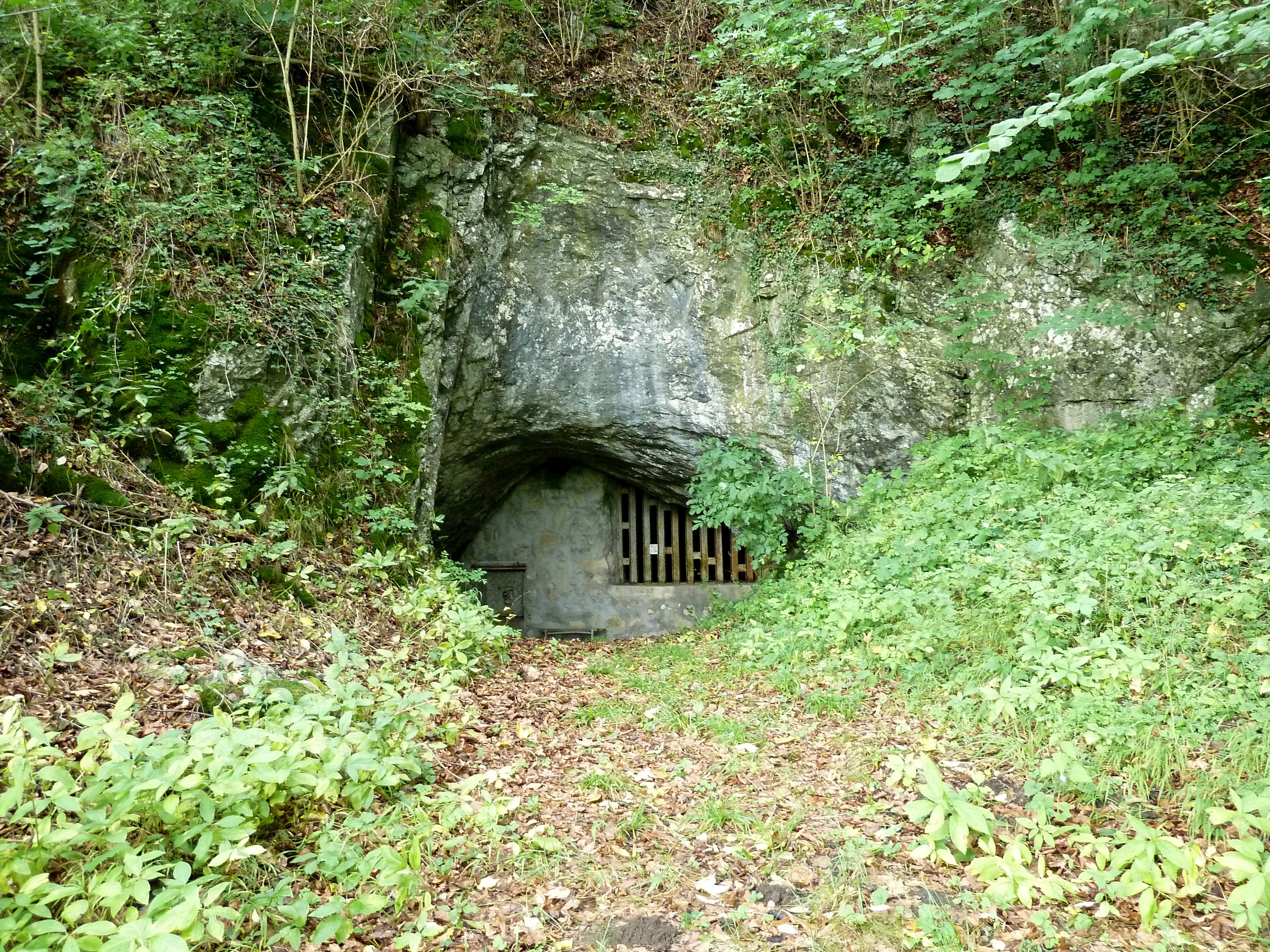
A cave entrance in a rocky cliff face surrounded by green forest vegetation, with a metal grate installed at the opening and a dirt path leading to it.
The entrance to the Hollenloch cave near Brilon, Rōsenbeck, secured with a metal gate.

Hollenloch history and protected-area timeline

Human presence in and around the Hollenloch extends far back into prehistory. Bone remains of cave bears and cave hyenas recovered from cave sediments indicate that the entrance was visited by large ice age mammals, and correspondingly by people who hunted or scavenged in the area. The first systematic archaeological investigations began in the first half of the 19th century and have continued intermittently since.

Surveys over more than a century have built up a continuous cultural sequence at the site. Neolithic period activity is well documented through flint arrowheads, scrapers, and blades, while fired and sometimes decorated pottery sherds indicate later prehistoric use of the cave. Iron Age finds, including brass, amber, and fired clay ornament fragments, show that the cave continued to be a meaningful location for human activity into the first millennium BCE.

In modern times, the cave has been managed primarily for conservation. The entrance was locked in 1960 to prevent unauthorized access, an effort prompted by repeated vandalism. The site had already been recognized before then as a Naturdenkmal, a natural monument, and in 2001 it was formally designated by the Hochsauerland district as the Naturschutzgebiet Hollenloch / Ziegentempel with an area of around 3.2 hectares, under the Hoppecketal landscape plan. At the same time, the cave and its surroundings were designated as the FFH area Rösenbecker Höhle under the European Union Habitats Directive, integrating the site into the Natura 2000 ecological network.

Hollenloch landscape and geographic character

Hollenloch lies in a landscape shaped almost entirely by its limestone geology. The bedrock is the Brilon Massenkalk, an Upper Devonian reef limestone that has been dissolved by groundwater over geological time to produce a textbook karst terrain. Surface indications of this underground activity include exposed limestone cliffs, fissures, and the Schwalgloch, a karst-related depression located within the protected area.

The cave entrance sits in a small outcrop of calcareous rock surrounded by forest, and the entrance area has been used as a natural refuge point for both animals and humans through the deep history of the region. Inside the cave, more than 2,700 meters of mapped passages descend to a depth of about 92 meters, with substantial stalactite decoration, including formations in the Apostelhalle, the Apostles' Hall. The cave is dry rather than active with underground streams, but the chemistry of dripping and seeping water continues to shape its formations.

Above the cave, the terrain is gently hilly rather than dramatic, but the local relief and shallow calcareous soils create the distinctive conditions that support the beech forest on limestone, a rare habitat type within the broader forested uplands of the Sauerland.
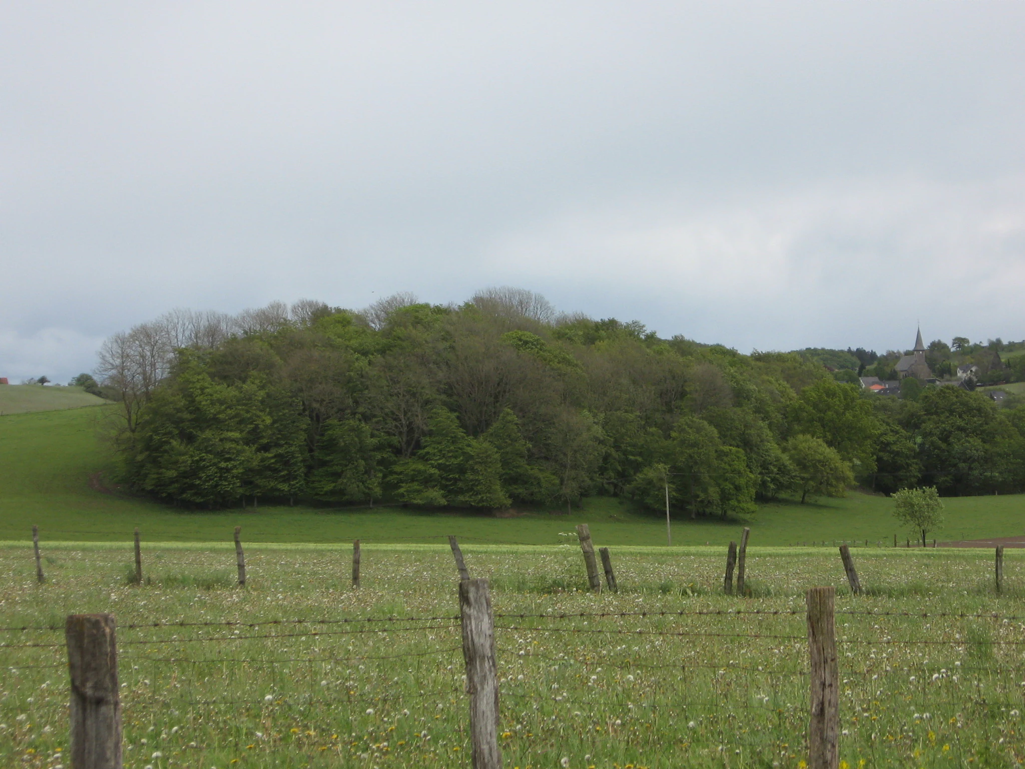
A green meadow with wooden fence posts in the foreground, a dense cluster of trees in the midground, and a village with a church steeple in the background under an overcast sky.
View of the Hollenloch nature reserve from the west, including the roofs and church of Rosenbeck in the background.

Hollenloch ecosystems, habitats, and plant life

The defining ecological character of Hollenloch is the combination of subterranean karst habitats with a surface limestone beech forest. The beech woodland on shallow, rocky, calcareous soils includes typical species of such woodland complexes, with herbaceous flora adapted to base-rich ground. Surveys by the North Rhine-Westphalian state office for nature, environment, and consumer protection have documented a broad herb and moss flora within the reserve.

Characteristic woodland herbs recorded include lily of the valley, lords-and-ladies, common figwort relatives, zigzag clover, sweet woodruff, wood avens, enchanters' nightshade, and angular Solomon's seal, alongside mosses such as the cypress plait-moss and various feather mosses and tongue mosses. The presence of species such as Alpine currant and brittle bladder fern is consistent with the cool, base-rich microclimate typical of such karst forests.

As a habitat mosaic, the site bridges surface and underground environments. The cave provides stable, cool conditions that support specialist cave fauna as well as hibernating bats, while the surrounding cliff, fissure, and slope systems support calcareous woodland communities. Together these elements create a layered habitat complex within a small protected footprint.

Hollenloch wildlife and species highlights

The wildlife profile of Hollenloch is defined largely by its role as a hibernation site for bats and as a refuge for cave-dwelling invertebrates. Seven different bat species have been recorded in the cave, including notable and regionally rare species such as the pond bat, Natterer's bat, and the whiskered bat.

A March 2006 count documented 77 hibernating bats across these species, while a February 2026 resurvey recorded 206 hibernating bats representing six species: the whiskered or Brandt's bat, pond bat, Daubenton's bat, Natterer's bat, brown long-eared bat, and greater mouse-eared bat. The greater mouse-eared bat was by far the most numerous, with 161 individuals counted, making the cave a regionally significant roost for this species.

Beyond bats, the cave also hosts specialist cave fauna, including cave spiders. The bat populations and the surrounding limestone beech forest together form the principal wildlife interest of the protected area, balanced on a small but exceptionally well-protected geological foundation.

Hollenloch conservation status and protection priorities

Conservation at Hollenloch operates on two complementary legal layers. Nationally, the site is designated as the Naturschutzgebiet Hollenloch / Ziegentempel under the Hoppecketal landscape plan established by the Hochsauerland district in 2001, covering about 3.2 hectares. Before that, the cave had already been protected as a Naturdenkmal, or natural monument.

In parallel, the site is designated as the FFH-Gebiet Rösenbecker Höhle under the European Union Habitats Directive, integrating the area into the Natura 2000 network. The stated protection purpose emphasizes the preservation of karst phenomena, the Hollenloch and Schwalgloch caves, for scientific, regional, geological, and species-protection reasons, alongside the conservation of calcareous beech forest communities on shallow, rocky soils.

In practical terms, the cave entrance has been locked since 1960, ending tourist development in favor of strict protection. Despite this, repeated vandalism at the closure has at times raised concerns within the district about whether more permanent sealing might be required. The cave's significance for hibernating bats, combined with its paleontological and archaeological resources, justifies the strict conservation regime that distinguishes Hollenloch from many other caves in the Sauerland.

Hollenloch cultural meaning and human context

The cultural identity of Hollenloch is closely tied to folklore as well as archaeology. The name Hollen derives from traditional beliefs about underground spirits and subterranean beings in German vernacular mythology, situating the cave within a long-standing regional landscape of stories about hidden places beneath the earth.

A nearby rock formation called Zur weißen Frau, the White Lady, is widely interpreted as a reinterpretation of an older wise-woman figure, and the cave and its surroundings have been linked to the broader wandering saga of Frau Holle, an important figure in German folk tradition. Beyond the folklore layer, the cave itself preserves a tangible human cultural record that stretches from the Paleolithic, through Neolithic flint working, to Iron Age ornament production, making the site a meeting point of mythology and deep prehistoric archaeology.

This blend of folkloric naming, prehistoric use, and modern scientific investigation gives Hollenloch a layered cultural significance, even though it has never been developed as a tourist attraction.

Top sights and standout views in Hollenloch

Hollenloch combines several distinct highlights within a small protected footprint. Its 2,700-meter-long, 92-meter-deep cave system ranks among the longest and deepest known caves in the Sauerland and contains well-developed speleothem decoration, including the visually named Apostelhalle. The cave is set in an Upper Devonian reef limestone that gives the site its characteristic surface karst features, cliff outcrops, and the adjacent Schwalgloch collapse.

Ecologically, the site is a regionally important bat hibernation site, with seven documented bat species and recent counts exceeding 200 hibernating individuals, including a major roost of the greater mouse-eared bat. Culturally and historically, the cave preserves Paleolithic animal bones, Neolithic flint tools, and Iron Age ornaments, layered beneath a strong local folklore tied to the name Hollen, subterranean spirits, and the legend of Frau Holle.

Best time to visit Hollenloch

Because the cave entrance at Hollenloch has been locked since 1960 to protect the cave from vandalism, the site is not generally open to visitors and cannot be entered at any time of year. For observers interested in the surface protected area, the surrounding limestone beech forest can be appreciated through the year, with the most atmospheric conditions typically found in late spring and early autumn, when the beech canopy is fully developed and the weather is mild enough for low-impact walks in the rolling terrain above the cave.

Winter is the period of greatest ecological significance for the cave itself, as it is the season when the largest numbers of hibernating bats are present, including regionally rare species. Anyone interested in the broader Sauerland karst landscape will find late spring through early autumn to be the most comfortable season for outdoor appreciation of the surface protected area.

Monthly climate preview

Track representative annual temperature swings and monthly precipitation patterns across the terrain

Hollenloch Climate Normals and Long-Term Weather by Month

Long-term data records reveal distinct seasonal temperature ranges and steady precipitation cycles sampled at representative coordinates across Hollenloch. Reviewing the complete monthly climate profile provides deeper context on measured thermal shifts and precipitation rhythms throughout the year.
Annual mean9 °C
0 °C18 °C
Jan
Feb
Mar
Apr
May12°
Jun15°
Jul18°
Aug18°
Sep14°
Oct
Nov
Dec
Warmest month
July

18 °C

Coolest month
January

-0.2 °C

Wettest month
July

2.6 mm/day

Driest month
April

1.7 mm/day

Park location guide

Geography guide, regional context, and park location map for Hollenloch

Hollenloch park geography, regions, and map view in Germany

Understand where Hollenloch sits in Germany through a broader geographic reading of the surrounding landscape, nearby location context, and its mapped position within the national park landscape.

How Hollenloch fits into Germany

Germany is a federal republic in Western and Central Europe with a population of over 83 million across sixteen constituent states. It is Europe's largest economy by nominal GDP and a major global exporter and importer. The capital is Berlin, and the country borders Denmark, Poland, Czech Republic, Austria, Switzerland, France, Luxembourg, Belgium, and the Netherlands.

Wider geography shaping Hollenloch in Germany

Germany is located in Western and Central Europe, spanning 357,022 km². It borders Denmark to the north, Poland and the Czech Republic to the east, Austria and Switzerland to the south, and France, Luxembourg, Belgium, and the Netherlands to the west. The country has coastlines on the Baltic Sea and North Sea to the north, with the Alps located in the southern region.

Map view of Hollenloch

Use this park location map to pinpoint Hollenloch in Germany, understand its exact geographic position, and read its mapped placement within the surrounding landscape more clearly.

Pigeon | © OpenStreetMap contributors

Location context for Hollenloch

North Rhine-Westphalia

Explore photographic records of limestone beech woodland, subterranean speleothems, and rugged surface terrain.

Hollenloch Photos and Karst Landscapes, Visualizing the Sauerland Cave Sanctuary

Visual documentation reveals the intricate reef limestone formations, surface fissures, and rare forest habitats that define Hollenloch. Examining these protected area photographs provides direct insight into the complex karst geology and subterranean ecology of the region.

A cave entrance in a rocky cliff face surrounded by green forest vegetation, with a metal grate installed at the opening and a dirt path leading to it.

Interior view of a cave chamber with large stalagmites and rocky formations on the floor and ceiling.

A green meadow with wooden fence posts in the foreground, a dense cluster of trees in the midground, and a village with a church steeple in the background under an overcast sky.

Park atlas

Compare connected karst landscapes and regional nature reserves

Parks Near Hollenloch and Other Protected Areas Across the Sauerland Region

Continue exploring other protected areas near Hollenloch to examine similar limestone geology and regional forest habitats. Comparing adjacent nature reserves provides a broader geographic view of the surrounding upland terrain.
A watercolor painting showing a soft, peaceful landscape with a small body of water in the foreground, surrounded by grassy banks and low hills in the distance.
Nature reserveHochsauerlandkreis
About 1.7 km away#1 closest

Southwest

Naturschutzgebiet Schwarzes Haupt: A Protected Limestone Landscape in Hochsauerlandkreis

Mapped calcareous grasslands and orchid-rich beech forests.

This nature reserve covers 9.8 hectares of the Schwarze Haupt hill, featuring a layered terrain of rocky outcrops, former quarry remnants, and rare grassland habitats. It serves as a critical site for regional biodiversity, linking calcareous ecosystems within the eastern Sauerland through its specialized beech forests and limestone cliff formations.

Area
0.098 km²
Established
2008
Relief
Upland
Scope
Terrestrial
A wide, pale watercolor illustration showing rolling green and yellow hills with scattered trees.
Nature reserveHochsauerlandkreis
About 4.6 km away#2 closest

West

Naturschutzgebiet Scheffelberg / Kalberstert: Mapped Limestone Hill Landscape

Nature reserve located within the Hochsauerlandkreis regional geography

Analyze the topographic features of the Naturschutzgebiet Scheffelberg / Kalberstert, including its conical rock outcrops and expansive dry grasslands. This protected area offers a clear look at the limestone hill systems defining this part of Hochsauerlandkreis, highlighting the intersection of beech woodland and open rocky terrain through detailed geographic mapping.

Area
0.456 km²
Established
2008
Relief
Upland
Climate
Temperate
A soft watercolor painting of a serene natural landscape with rolling hills, a central body of water, and green trees against a pale, warm-toned sky.
Nature reserveWaldeck-Frankenberg
About 4.9 km away#3 closest

South

Naturschutzgebiet Diemelsee Nature Reserve: Geographic Atlas and Protected Landscape

Waldeck-Frankenberg Wetland and Reservoir Margin Analysis

Located in northern Hesse, Naturschutzgebiet Diemelsee serves as a crucial protected sanctuary where the Itter stream enters the reservoir. This reserve features a distinctive mosaic of mudflats, reed beds, and swamp-like woodland, shaped by annual water level changes that create a unique habitat for local birdlife and pioneer flora within the broader Sauerland foothills.

Area
0.187 km²
Established
1965
Relief
Lowland
Scope
Terrestrial
A soft watercolor illustration of a landscape featuring layered green hills, a distant forest silhouette, and pale sky, rendered in a light, minimalist style.
Nature reserveHochsauerlandkreis
About 6.3 km away#4 closest

East

Naturschutzgebiet Oberes Diemeltal: Protected Floodplain and River Geography in Hochsauerlandkreis

Mapped riparian landscapes and riverine conservation corridors

Naturschutzgebiet Oberes Diemeltal preserves an undeveloped section of the upper Diemel river valley. The landscape is defined by its branching river network, wet meadows, and rare floodplain vegetation, offering a clear window into the riverine geography of the eastern Sauerland region in Germany.

Area
1.87 km²
Established
2001
Scope
Terrestrial
Water
Major water bodies
A horizontal watercolor illustration of a soft, hazy valley with rolling green hills, distant treelines, and wildflowers in the foreground.
Nature reserveNorth Rhine-Westphalia
About 6.7 km away#5 closest

Northeast

Naturschutzgebiet Aabachtal Nature Reserve and Sauerland Protected Stream Valley Geography

A preserved fluvial landscape in North Rhine-Westphalia

Naturschutzgebiet Aabachtal is a protected nature reserve in the northern Sauerland of North Rhine-Westphalia. Centered on the Aabach stream, it protects a classic Mittelgebirge valley landscape defined by meandering watercourses, lush floodplain meadows, and deciduous forest slopes, serving as a critical habitat for specialized moisture-loving flora and diverse riparian fauna.

Area
0.716 km²
Established
2001
Relief
Upland
Scope
Terrestrial
A horizontal watercolor painting showing rolling, abstract hills with patches of green, yellow, and soft red, accented with stylized coniferous forest lines.
Nature reserveNordrhein-Westfalen
About 6.8 km away#6 closest

North

Leiberger Wald Nature Reserve: Protected Woodland and Stream Geography in Paderborn

A mapped forest complex within the Nordrhein-Westfalen landscape

Leiberger Wald encompasses an extensive series of beech forests and riparian habitats that form a key protected node in the Kreis Paderborn. As a significant nature reserve, the area supports a wide range of woodland and aquatic species, serving as a critical refuge within the broader ecological network of western Germany.

Area
17.86 km²
Established
1994
IUCN
IV
A watercolor landscape illustration showing soft, rolling green hills, coniferous trees, and a hazy background.
Nature reserveHochsauerlandkreis
About 7.2 km away#7 closest

East

Naturschutzgebiet Padberg: A Protected Landscape in the Hochsauerlandkreis Region

Diabas geology and forest habitat mapping

Naturschutzgebiet Padberg protects a compact but ecologically rich landscape of beech forests and craggy rock cliffs. Its position above the Diemel valley highlights the relationship between volcanic Diabas topography and woodland development within the Hochsauerlandkreis district.

Area
0.467 km²
Established
2001
Relief
Upland
Climate
Temperate
Nature reserveNorth Rhine-Westphalia
About 7.9 km away#8 closest

Southwest

Naturschutzgebiet Poppenberg: A Detailed Geographic Overview of this Nature Reserve

Exploring Limestone Cliff Habitats and Regional Forest Ecosystems

Naturschutzgebiet Poppenberg represents an essential ecological link within the Brilon limestone hill network. This nature reserve offers a concentrated study in geology and ecology, showcasing exposed rock formations, historical mining traces, and a diverse range of woodland habitats compressed into a compact, protected area within North Rhine-Westphalia.

Area
0.007 km²
Established
2008
Relief
Upland
Climate
Temperate

Common questions about visiting, size, designation, and location context for Hollenloch

Hollenloch FAQs for park facts, access, geography, and protected area context

Find quick answers about Hollenloch, including protected-area facts, park geography, trail and visitor context, and how the park fits into its surrounding country and regional landscape.
MoriAtlas Explorer

Continue Your Protected Areas Search Across the Global Atlas

Deepen your exploration by continuing the structured search for national parks and protected areas worldwide. Utilize the comprehensive filtering capabilities to compare different conservation landscapes and refine your understanding of global park geography. Discover more about the distribution and characteristics of protected natural areas.

Global natural geography