Mori Atlas logo
Wildlife reserveHorseshoe Bay Wilderness

Mapping the ecological geography of a unique forested wilderness reserve in the Michigan Upper Peninsula

Horseshoe Bay Wilderness: A Protected Post-Glacial Wetland and Lake Huron Shoreline Landscape

Horseshoe Bay Wilderness is a significant 3,787-acre protected area in Michigan, defined by its complex post-glacial wetland systems and expansive shoreline along Lake Huron. Located within the Hiawatha National Forest, this wilderness reserve showcases a rare transition from humid inland cedar and paper birch forests to shallow, quiet coastal waters. The landscape offers a window into the regional geography of the Upper Peninsula, where ancient lakebed shifts have created essential fish spawning habitat and refuge for waterfowl.

wilderness areawetland ecosystemLake Huron shorelineGreat Lakes coastal forestriparian wetlandspaper birch forest

Horseshoe Bay Wilderness

Wildlife reserve

Park overview

Structured park overview, official facts, and landscape profile for Horseshoe Bay Wilderness

Horseshoe Bay Wilderness park facts, protected area profile, and essential visitor context

Review the core facts for Horseshoe Bay Wilderness, including designation, size, terrain, visitor scale, habitats, and operating context in one park-focused overview.

About Horseshoe Bay Wilderness

Horseshoe Bay Wilderness is a small but ecologically distinctive protected area in Michigan's Upper Peninsula, occupying a stretch of forested shoreline along Horseshoe Bay in the northwestern corner of Lake Huron. Although the wilderness itself covers just 3,787 acres, its setting places it at the meeting point of Lake Huron and the Straits of Mackinac, a strategic and scenic transitional zone between two of the Great Lakes. As part of the much larger Hiawatha National Forest, the wilderness represents a more strictly protected enclave within a working, multi-use national forest landscape.

The defining character of the wilderness is its wetland ecology. After the most recent ice age, lake levels gradually receded, leaving rolling stretches of former lakeshore and lakebed as riparian wetlands. Over thousands of years these low-lying areas developed into a humid, forested environment dominated by moisture-adapted tree species. This sequence of natural processes gives the wilderness its quiet, low-relief topography and creates a continuous transition from upland forest into bayshore marsh and open Lake Huron water.

Although it is situated close to busy transportation corridors, including Interstate 75 and County Highway H-63, the wilderness preserves an unusually tranquil stretch of Great Lakes coast. A short, often-damp U.S. Forest Service trail leads from an adjacent campground and parking area to the bay shoreline, offering access to a landscape that feels far more remote than its inland location suggests.

Quick facts and research context for Horseshoe Bay Wilderness

Horseshoe Bay Wilderness is a 3,787-acre wilderness area managed by the U.S. Forest Service within Hiawatha National Forest. It lies in Mackinac County, Michigan, along the northern edge of Lake Huron near the Straits of Mackinac, with the nearest major town being St. Ignace about five miles to the south. Designated by Congress in 1987, it protects a forested wetland ecosystem shaped by the receding lake levels that followed the most recent glaciation.

Protection and recognition

Documented terrestrial protection scope and historical designation data

Horseshoe Bay Wilderness Protection Status and Designation History

Horseshoe Bay Wilderness holds a documented terrestrial protection status established in 1987. Official records track the designation history and management scope without additional international recognition sources.

Protection details

Protection scope
Terrestrial
Designated year
1987
Transboundary protection
No
Park context

Deeper park guide and search-rich context for Horseshoe Bay Wilderness

Horseshoe Bay Wilderness history, landscape, wildlife, and travel context

Explore Horseshoe Bay Wilderness through its history, landscape character, ecosystems, wildlife, conservation priorities, cultural context, and seasonal travel timing in a structured park guide built for atlas discovery and search intent.

Why Horseshoe Bay Wilderness stands out

Horseshoe Bay Wilderness is best known for its forested wetland ecosystem along the northwestern shore of Lake Huron. The wilderness protects a former post-glacial lakeshore that has developed into a humid, low-lying forest of paper birch and northern whitecedar. It is also recognized for its quiet Great Lakes shoreline and its value as fish spawning habitat for the broader Lake Huron aquatic system.

Horseshoe Bay Wilderness history and protected-area timeline

The present-day Horseshoe Bay Wilderness sits on land that carries a long human history stretching back to Native American use of the bay waters for fishing and canoe building. Indigenous communities harvested birch bark and cedar roots from the local plant life to construct the canoes they used to take advantage of Horseshoe Bay's fish resources, and they recognized early on what makes this shoreline ecologically productive.

In the more recent industrial era, the area was thoroughly logged by timber companies. After those operations concluded, the cut-over land reverted to public ownership and was incorporated into the national forest system. In 1987, the U.S. Congress designated a portion of national forest land along the shoreline of Horseshoe Bay as a federally protected wilderness area, formalizing its status as the Horseshoe Bay Wilderness. The U.S. Forest Service has since maintained a short trail leading into the wilderness from the adjacent Foley Creek parking lot and campground, supporting limited low-impact recreation while preserving the area's wilderness character.

Horseshoe Bay Wilderness landscape and geographic character

The landscape of Horseshoe Bay Wilderness is shaped by the post-glacial history of the northern Lake Huron basin. As water levels fell in the wake of the last ice age, the receding shoreline left behind broad stretches of former lakebed and gently rolling former shores. These exposed flats evolved into riparian wetlands that today define the topography of the wilderness: low-lying, soft, often damp ground that gradually transitions inland into forested wetland and out toward the open water of Horseshoe Bay.

The shoreline itself is shallow and curved, giving the bay its name, and the wilderness follows much of that arc. Slow-moving tributary streams drain the interior wetland into the bay, contributing to the calm, sheltered character of the near-shore waters. The relief is modest, without dramatic cliffs or mountains, but the scenery is defined by the visual contrast between dense wetland forest, wet meadow openings, and the broad sweep of Lake Huron to the east.

Horseshoe Bay Wilderness ecosystems, habitats, and plant life

The ecological identity of Horseshoe Bay Wilderness centers on its forested wetland environment. Because the underlying landscape is essentially a former glacial lakebed that has not fully drained, the soil and air tend to remain humid, and the vegetation is dominated by tree and plant species that thrive under those conditions. Paper birch and northern whitecedar are characteristic canopy trees, while the broader plant community reflects the gradual transitions between saturated ground, partially drained wetland margins, and seasonally drier upland pockets.

The wetland acts as an ecological link between terrestrial and aquatic environments. Runoff from the wetland feeds the slow tributaries that reach Horseshoe Bay, and the bay's shallow, sheltered waters are an important zone for fish spawning. That intersection of swamp, stream, shallow bay, and open lake creates conditions that support a wide range of species, including moisture-loving plants, aquatic invertebrates, forage fish, larger predatory fish in Lake Huron, and waterfowl that depend on the bay for feeding.

Horseshoe Bay Wilderness wildlife and species highlights

Wildlife in Horseshoe Bay Wilderness is strongly shaped by the wetland and shoreline environment. The shallow margins of Horseshoe Bay and the slow-moving streams that drain the wetland provide productive spawning habitat for fish, while the broader expanse of adjacent Lake Huron supports a diverse fish community. This aquatic productivity in turn feeds a recognizable presence of fish-eating birds, including wading species such as the great blue heron, which is commonly seen along the bay shoreline.

Beyond birds, the forested wetland offers typical habitat for Great Lakes region wildlife adapted to damp, mixed forest conditions. The combination of dense cover, standing water, slow streams, and a relatively undisturbed bayshore makes the wilderness a refuge for species that depend on this kind of low-impact shoreline habitat. While the relatively small size of the wilderness limits populations of larger mammals, the broader Hiawatha National Forest landscape surrounding it provides additional range for animals that move through the protected area.

Horseshoe Bay Wilderness conservation status and protection priorities

Horseshoe Bay Wilderness was designated in 1987 under the federal Wilderness Preservation System, giving it the highest level of protection available on U.S. national forest lands. The wilderness designation restricts development, motorized access, and most forms of active management, ensuring that the wetland forest and the bayshore shoreline remain in a relatively natural state. By protecting these habitats, the wilderness helps preserve an important transitional zone between land and water along one of the most ecologically significant stretches of the Great Lakes coast.

From a conservation perspective, the wilderness matters less for its size than for the ecological functions it sustains. Its wetlands filter runoff before it reaches Horseshoe Bay, the slow tributaries and shallow bay margins provide spawning and nursery habitat for Lake Huron fish, and the intact bayshore supports feeding habitat for water birds and other wildlife. Protecting this compact area therefore contributes meaningfully to the health of the broader Lake Huron ecosystem.

Horseshoe Bay Wilderness cultural meaning and human context

The cultural history of the Horseshoe Bay shoreline reaches back to the Native American communities who relied on the bay's fish resources. Indigenous people harvested fish from Horseshoe Bay and used locally gathered materials, including birch bark and cedar roots, to construct the canoes that made fishing possible. This historic use reflects a long-standing relationship between the human communities of the Upper Great Lakes and the wetland and bayshore ecosystems that still define the wilderness today.

In the modern era, the area's cultural identity has shifted toward low-impact outdoor recreation within a nationally protected landscape. The presence of a Forest Service trail and a nearby campground reflects a management outlook that balances access with the preservation of wilderness character, and the proximity of St. Ignace and the Mackinac region places Horseshoe Bay Wilderness within an area rich in Great Lakes regional heritage.

Top sights and standout views in Horseshoe Bay Wilderness

The strongest features of Horseshoe Bay Wilderness are its compact scale, its post-glacial wetland character, and its direct frontage on Lake Huron's northwestern corner. The forested wetland ecosystem, with its paper birch and northern whitecedar stands, offers a distinctly humid forest experience that contrasts with the drier forests more commonly associated with the Upper Midwest. The curved shoreline of Horseshoe Bay itself provides quiet water, shallow fish habitat, and dependable sightings of fish-eating birds such as great blue herons.

For visitors, the wilderness's defining appeal lies in how quickly it transitions from inland wetland forest to open Great Lakes shoreline, all within a short trail. The combination of accessible location near St. Ignace and Interstate 75 with true wilderness shoreline makes Horseshoe Bay Wilderness one of Michigan's noteworthy small protected areas along Lake Huron.

Best time to visit Horseshoe Bay Wilderness

The most rewarding conditions for visiting Horseshoe Bay Wilderness tend to align with the ice-free months of late spring, summer, and early fall, when the wetland forest is in leaf and waterfowl, including fish-eating species such as great blue herons, are easiest to observe along the bay. Summer offers the warmest conditions for experiencing the bayshore, though visitors should expect damp ground underfoot and significant mosquito presence, both of which are characteristic of the wetland environment.

Shoulder seasons in spring and autumn can also be appealing because cooler weather reduces insect pressure, and the changing forest colors highlight the contrast between birch and northern whitecedar stands. Because access involves a short, often saturated trail and conditions can be wet at any time of year, visitors planning to see the shoreline up close should expect damp ground conditions and prepare accordingly.

Monthly climate preview

Long-term temperature ranges and precipitation rhythm for Michigan protected terrain

Horseshoe Bay Wilderness Climate Normals and Monthly Weather Patterns

Representative coordinate records show measured annual temperature fluctuations and monthly precipitation totals across the protected landscape. Examining the full twelve-month profile provides complete historical context for long-term climate normals.
Annual mean6 °C
-6 °C18 °C
Jan-6°
Feb-6°
Mar-3°
Apr
May
Jun14°
Jul18°
Aug18°
Sep15°
Oct
Nov
Dec-2°
Warmest month
August

18.3 °C

Coolest month
January

-6.3 °C

Wettest month
October

3.3 mm/day

Driest month
February

1.4 mm/day

Park location guide

Geography guide, regional context, and park location map for Horseshoe Bay Wilderness

Horseshoe Bay Wilderness park geography, regions, and map view in United States of America

Understand where Horseshoe Bay Wilderness sits in United States of America through a broader geographic reading of the surrounding landscape, nearby location context, and its mapped position within the national park landscape.

How Horseshoe Bay Wilderness fits into United States of America

The United States of America is a federal presidential republic and one of the world's largest countries by area and population. It consists of 50 states across a vast territory spanning multiple time zones, with its capital in Washington, D.C. and largest city in New York City. The nation has a diverse economy, influential political system, and significant cultural and military presence globally.

Wider geography shaping Horseshoe Bay Wilderness in United States of America

The United States occupies a vast territory in North America, bordered by Canada to the north and Mexico to the south. The 48 contiguous states stretch from the Atlantic to the Pacific Ocean, while Alaska occupies the northwestern region and Hawaii is an archipelago in the Pacific. The country encompasses diverse terrain including the Rocky Mountains, Appalachian Mountains, Great Plains, and extensive river systems.

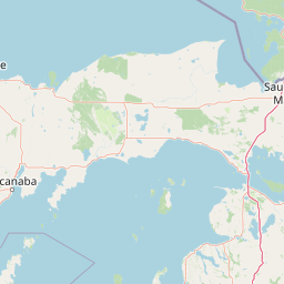
Map view of Horseshoe Bay Wilderness

Use this park location map to pinpoint Horseshoe Bay Wilderness in United States of America, understand its exact geographic position, and read its mapped placement within the surrounding landscape more clearly.

Pigeon | © OpenStreetMap contributors

Location context for Horseshoe Bay Wilderness

Michigan
Natural feature types

Examine the Natural Features and Geographic Landscape of Horseshoe Bay Wilderness

Deepen your understanding of this protected area by browsing its diverse natural features. MoriAtlas provides a structured look at the forested wetlands, riparian streams, and Great Lakes coastal terrain that define the Horseshoe Bay Wilderness landscape.
Park atlas

Compare surrounding regional park geography and connected Great Lakes protected landscapes.

Parks Near Horseshoe Bay Wilderness and Related Protected Areas in the Region

Explore other protected areas near Horseshoe Bay Wilderness to examine similar post glacial wetland ecosystems and coastal Great Lakes terrain. Comparing adjacent wilderness tracts reveals broader ecological patterns across the northern Lake Huron shoreline.
A watercolor painting of a rolling, soft-toned landscape with a foreground of green forest and layers of hills receding into the distance.
Protected landscapeUpper Peninsula of Michigan
Park boundaries overlap#1 closest

West

Hiawatha National Forest: Geographic Overview and Protected Area Map of the Upper Peninsula

Coastal forest landscape and wilderness river corridors.

Hiawatha National Forest spans significant portions of the Upper Peninsula of Michigan, bridging the gap between northern hardwood forests and the boreal environments of the Great Lakes. This protected landscape encompasses extensive shorelines along Lake Superior, Lake Michigan, and Lake Huron, alongside six wilderness areas and five designated wild and scenic rivers.

Area
3,621.27 km²
Established
1931
IUCN
VI
Relief
Lowland
Wildlife reserveMichigan
8.2 km away#2 closest

Northwest

Mackinac Wilderness Protected Area: Glacial Terrain and River Geography in Upper Michigan

A roadless wilderness reserve within Hiawatha National Forest

Uncover the geographic significance of Mackinac Wilderness, an IUCN Category Ib protected area in Michigan. The unit provides a distinct look at northern forest recovery through a terrain of sandy ridges, aspen and birch cover, and aquatic corridors. This study examines the interplay between postglacial landforms and the ongoing natural succession occurring along the Carp River drainage basin.

Area
49.5 km²
IUCN
Ib
Relief
Lowland
Climate
Temperate
A watercolor painting showing a winding river flowing through a lush, green valley with rolling mountains in the distance.
Wildlife reserveUnited States of America
About 16 km away#3 closest

Southeast

Round Island Wilderness: Geographic Overview of the Straits of Mackinac Wildlife Reserve

Coastal marsh, conifer forest, and hardwood interior terrain

Round Island Wilderness encompasses nearly all of a 378-acre island sanctuary, distinguished by its mature beech-maple hardwood interior and boreal-leaning conifer forests. This protected land remains an essential study of Great Lakes island ecology, standing as a quiet, undisturbed wilderness edge along the transit routes of the Michigan straits.

Area
1.53 km²
Relief
Lowland
Climate
Temperate
Access
Remote access
Marine protected areaMichigan
31 km away#4 closest

Southeast

Thunder Bay National Marine Sanctuary: Geography and Protected Maritime Landscape Context

Mapping underwater heritage in the Michigan Great Lakes region

Spanning 4,300 square miles of Lake Huron, Thunder Bay National Marine Sanctuary preserves a significant collection of shipwrecks within a glacially shaped freshwater terrain. This marine protected area offers a look at submerged geography ranging from shallow coastal bays to deep lake basins. It serves as a vital anchor for understanding maritime history and freshwater ecosystem stability across the Michigan shoreline.

Area
11,000 km²
Established
2000
Relief
Lowland
Climate
Temperate
A soft watercolor painting showing green rolling hills, a calm body of water, and small clusters of pink flowers against a light, hazy background.
National parkMichigan
130 km away#5 closest

Southwest

Sleeping Bear Dunes National Lakeshore: Atlas, Maps, and Protected Landscape Geography

Great Lakes freshwater coast and glacial dune systems

Sleeping Bear Dunes National Lakeshore showcases the unique intersection of glacial geology and freshwater ecology. This protected area features massive dunes resting on ancient glacial deposits, backed by beech and maple forests. The geographic scope includes the vast shoreline of Lake Michigan, inland waters such as Glen Lake, and the distinct maritime history found across the remote North and South Manitou Islands.

Area
288.13 km²
Established
1970
IUCN
III
Visitors
1.5M annual
A watercolor painting showing a rolling landscape with green fields, sandy dunes, and a purple mountain range in the distance.
Natural monumentAlger County
About 137 km away#6 closest

Northwest

Pictured Rocks National Lakeshore: Geographic Atlas of Cliffs and Shoreline Terrain

Protected landscape geography in Alger County, Michigan

Pictured Rocks National Lakeshore offers a deep look into the Great Lakes coastal geography. Explore the intersection of Cambrian-era sandstone cliffs, perched dune systems, and inland forested wilderness. This area provides a clear record of glacial and lake-driven erosion, featuring unique formations like Miners Castle and Chapel Rock across its extensive Lake Superior boundary.

Area
296.38 km²
Established
1966
IUCN
III
Visitors
953.1K annual
Marine protected areaMichigan
About 155 km away#7 closest

Southeast

Thunder Bay National Marine Sanctuary and Underwater Preserve: Geography and Protected Area Atlas

Maritime heritage sites and glacial freshwater geography in Lake Huron, Michigan.

Situated along the rugged northeastern coast of Lake Huron, Thunder Bay National Marine Sanctuary and Underwater Preserve protects over two hundred shipwreck sites spanning nearly two centuries of maritime history. This marine protected area offers a unique intersection of submerged archaeological resources, shallow shoals, coastal marshes, and limestone bedrock, forming a vital freshwater ecosystem in the Great Lakes region of Michigan.

Area
11,000 km²
Established
2000
Relief
Lowland
Climate
Temperate
A horizontal watercolor painting showing a quiet lake surrounded by light green pine trees and soft, rolling hills in the distance.
Protected landscapeMichigan
About 162 km away#8 closest

South

Huron, Manistee National Forests: Geography, Protected Land, and Michigan Landscape Atlas

Exploration of glacial terrain, river basins, and coastal wilderness.

The Huron, Manistee National Forests stand as a significant protected landscape in northern Michigan, featuring a vast network of inland rivers and lakes. This atlas entry provides geographic context on its glacial geology, the rare dune ecosystems along Lake Michigan, and the distribution of pine-dominated forest habitats across the two administrative units.

Area
3,960 km²
IUCN
VI
Relief
Lowland
Climate
Temperate

Common questions about visiting, size, designation, and location context for Horseshoe Bay Wilderness

Horseshoe Bay Wilderness FAQs for park facts, access, geography, and protected area context

Find quick answers about Horseshoe Bay Wilderness, including protected-area facts, park geography, trail and visitor context, and how the park fits into its surrounding country and regional landscape.
MoriAtlas Explorer

Continue Your Protected Areas Search Across the Global Atlas

Deepen your exploration by continuing the structured search for national parks and protected areas worldwide. Utilize the comprehensive filtering capabilities to compare different conservation landscapes and refine your understanding of global park geography. Discover more about the distribution and characteristics of protected natural areas.

Global natural geography