
Mori Atlas logo
Nature reserveHühnermoor

Examining the ecological history and mapped terrain of a rare raised-bog refuge

Hühnermoor Nature Reserve: A Protected Peatland Landscape in the Münsterland Region

(Naturschutzgebiet Hühnermoor)

Hühnermoor occupies a distinct, closed topographic depression within the lowlands of Nordrhein-Westfalen, serving as a rare relict of raised-bog terrain shaped over millennia. This nature reserve provides essential habitat for specialist bog flora and dragonfly populations, acting as a scientifically vital archive of regional vegetation history. The site remains a protected focal point for understanding peatland ecosystems and the surrounding geological dune landscapes of the Münsterland region.

raised bogpeatlandnature reservewetlandMünsterlandNorth Rhine-Westphalia
A flat-style digital illustration showing a winding stream leading to a waterfall between mountain peaks, framed by coniferous trees and marshy foreground vegetation.

Hühnermoor

Nature reserve

Park overview

Structured park overview, official facts, and landscape profile for Hühnermoor

Hühnermoor park facts, protected area profile, and essential visitor context

Review the core facts for Hühnermoor, including designation, size, terrain, visitor scale, habitats, and operating context in one park-focused overview.

About Hühnermoor

Hühnermoor is a compact, state-level nature reserve in the Münsterland region of western North Rhine-Westphalia, situated near the village of Marienfeld in a farmland-dominated part of the Kreis Gütersloh. Although it covers only about 8.5 hectares, it represents an exceptional ecological island within an intensively cultivated environment where surviving peatlands of any kind have become rare.

The reserve sits on the edge of the Lutter, a small stream that runs through the broader landscape, and occupies a closed depression between two ancient sand dunes. Over roughly four thousand years, waterlogged, nutrient-poor, and extremely acidic conditions allowed peat to accumulate here, producing what once was a functioning raised bog. Peat cutting and drainage have since altered the hydrology, so the bog is today in a transitional state between a true raised bog and a flat bog. Even in this altered condition, however, the site retains an unusually dense concentration of typical high-bog plants on a very small surface.

Because such habitats have all but vanished from the wider lowlands of western Germany, Hühnermoor's significance is not in its size but in the rarity of what it preserves. Ecologists treat the site as both an active refuge for bog specialists and a historical archive, since the peat layers hold preserved pollen that documents plant communities from many centuries past. The site is also valued for its dragonfly diversity, making it a focal point for monitoring wetland invertebrates in the region. Although the area has been formally protected since 1938, ongoing challenges from airborne nutrient deposition mean that conservation efforts continue to focus on preventing further degradation of the surviving bog vegetation.

Quick facts and research context for Hühnermoor

Hühnermoor is a small nature reserve of approximately 8.5 hectares in the Kreis Gütersloh, North Rhine-Westphalia, Germany. It is classified as an IUCN Category IV protected area, focused on habitat and species management.

First placed under nature protection in 1938 and revised by a new ordinance from the Regierungspräsident in Detmold in 1965, the site was acquired by the Kreis Gütersloh in 1986 to secure its peatland habitat. The peatland originated over about four thousand years and is now in a transition between a raised bog and a flat bog, while still retaining significant high-bog vegetation communities.

Protection and recognition

Terrestrial protected area designation history and management scope facts

Hühnermoor Protection Status and Documented Conservation History

Established with a 1965 designation year, Hühnermoor maintains a terrestrial protection scope recorded within global databases. Documented records provide verified administrative history and official designation parameters without external recognition sources.

Protection details

Protection scope
Terrestrial
Designated year
1965
Transboundary protection
No
WDPA ID
81953
Park context

Deeper park guide and search-rich context for Hühnermoor

Hühnermoor history, landscape, wildlife, and travel context

Explore Hühnermoor through its history, landscape character, ecosystems, wildlife, conservation priorities, cultural context, and seasonal travel timing in a structured park guide built for atlas discovery and search intent.

Why Hühnermoor stands out

Hühnermoor is best known as a tiny surviving raised-bog fragment in an otherwise intensively cultivated landscape, hosting rare high-moor plant species and an exceptional dragonfly fauna in a protected natural setting. The reserve's geological history is part of its appeal as well. Because peat formation has recorded pollen from previous plant communities over several millennia, the site is valued as a natural archive of regional vegetation history, making it scientifically as well as ecologically interesting despite its modest size.
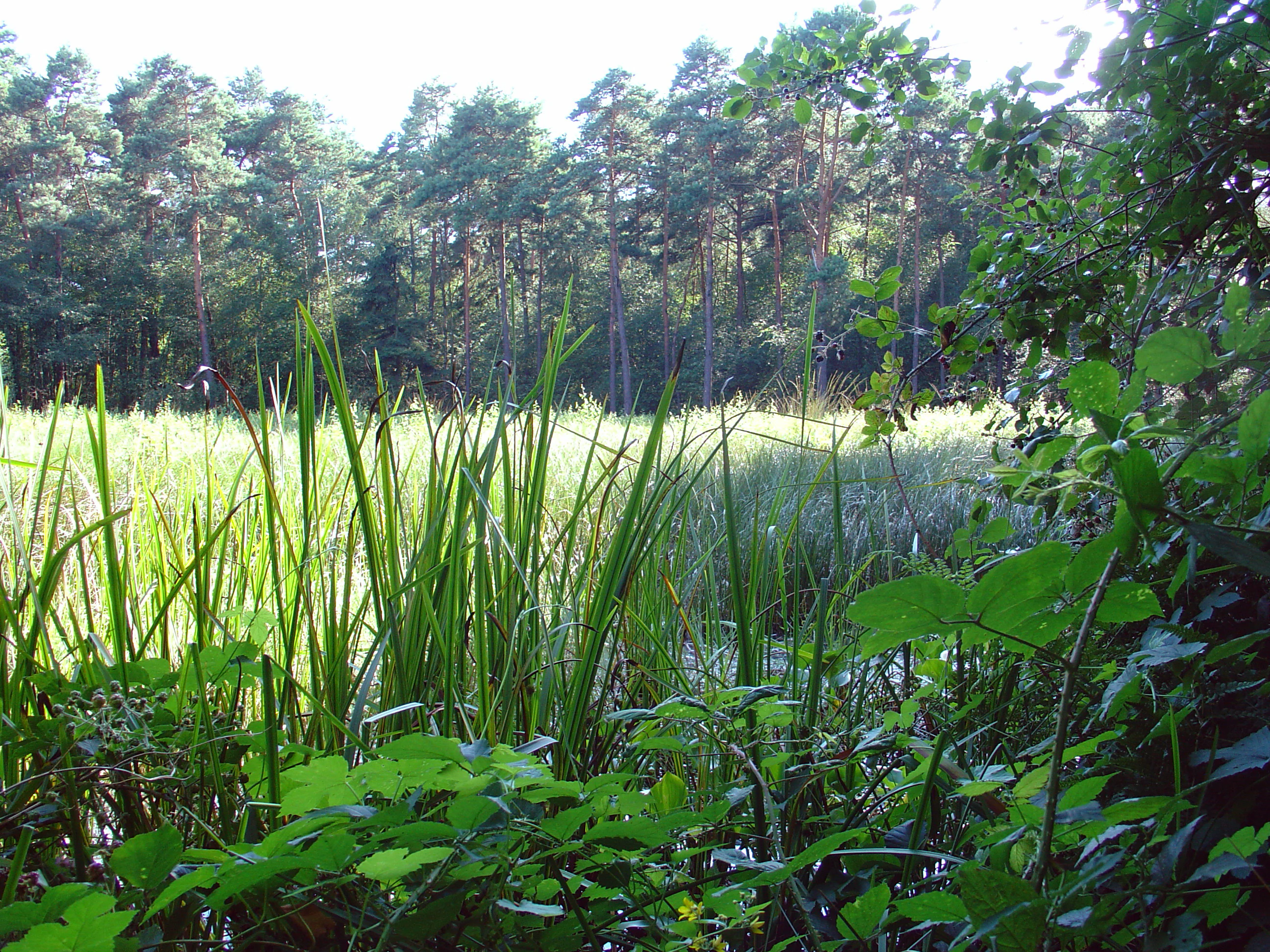
A view of the Hühnermoor nature reserve featuring a marshy area with tall reeds and grasses in the foreground, bordered by a dense forest of pine trees in the background.
Vegetation at the Hühnermoor nature reserve.

Hühnermoor history and protected-area timeline

Hühnermoor was first placed under formal nature protection in 1938, recognizing its importance as one of the surviving peatland remnants in the district. A revised protection ordinance was issued on 2 June 1965 by the Regierungspräsident of Detmold, updating the legal framework around the site.

A major step in long-term conservation came in 1986, when the Kreis Gütersloh purchased the land within the reserve. This acquisition ended decades of conflicting land use and gave the local authority direct control over the management of the bog, allowing active measures to protect its hydrology and vegetation. The acquisition reflects a broader recognition of peat bogs as irreplaceable habitats whose value lies not only in their present ecology but also in the historical record contained within their peat layers.

Hühnermoor landscape and geographic character

The reserve occupies a shallow, closed depression in the lowlands of North Rhine-Westphalia, framed by two ancient sand dunes that mark the edge of the original dune belt of the region. This slight topographic bowl, combined with poor drainage, created the conditions under which peat could accumulate continuously over thousands of years.

Today, the landscape of Hühnermoor reads as a small, dense mosaic of wet bog vegetation set against an agricultural backdrop. Although peat cutting and artificial drainage have flattened parts of the original raised dome, the surface still expresses a distinctive peatland topography with moist, spongy ground and visibly stratified peat layers. Trails around the reserve allow visitors to look into the bog without stepping on the sensitive peat surface, while the contrast between the wet reserve and the surrounding farmland emphasizes how unusual this relict landscape has become.

Hühnermoor ecosystems, habitats, and plant life

The ecological core of Hühnermoor is its surviving high-bog flora on a confined surface, including cotton grass, round-leaved sundew, cranberry, and bog bilberry, all species associated with extremely nutrient-poor, acidic conditions. The presence of these plants in such a small area gives the reserve disproportionate ecological value within the regional landscape.

Bog habitats support highly specialized communities, but they are also exceptionally fragile. Airborne nutrient inputs from agricultural surroundings have encouraged colonization by eutrophication indicators such as soft rush, which has displaced typical bog vegetation in some sections. A formerly recorded bog rosemary population is now considered lost from the site, illustrating both the ecological specificity and the vulnerability of such communities. Since 1975, marsh calla, a species more typical of transitional mires, has established itself at Hühnermoor, adding another characteristic wetland element to the flora.

The hydrology of the reserve is shaped by its position along the Lutter stream, which supplies the moisture necessary for peat-forming processes. Maintaining that hydrology is central to keeping the raised-bog character of the site viable, and it remains the main focus of ongoing conservation action.

Hühnermoor wildlife and species highlights

Hühnermoor is particularly notable for its dragonfly fauna, which thrives in the open, acidic bog waters that still exist on the site. The Small Whiteface, a dragonfly characteristic of raised-bog waters, occurs here and is regarded as a regionally threatened species in North Rhine-Westphalia.

Reptiles are also part of the reserve's fauna, with the slow worm recorded in the area. Observation from managed trails allows visitors to watch territorial, mating, and egg-laying flights of dragonflies with binoculars without disturbing the habitat. Because the reserve enforces a full access prohibition on the bog surfaces themselves, with visitors directed to perimeter paths, wildlife observation is by design low-impact and respectful of the breeding cycles of the dragonfly populations.

Hühnermoor conservation status and protection priorities

Hühnermoor's conservation significance lies in its function as a refuge for bog ecosystems that have otherwise disappeared from the farmed lowlands of the Münsterland region. The site's small size makes it especially vulnerable to any change in water quality, nutrient inputs, or hydrology, and it is managed with the understanding that peatland restoration depends on stable, extremely low-nutrient conditions.

The acquisition of the land by the Kreis Gütersloh in 1986 was an important conservation turning point, transferring responsibility for the site from private owners to the public authority and aligning its management with ecological priorities. Designation as a Naturschutzgebiet under German nature protection law, originally in 1938 and reinforced by a 1965 ordinance, supports strict regulation of land use around the bog. Its IUCN Category IV status, focused on habitat and species management, reflects the site's role in active conservation rather than pure wilderness preservation, while the strict visitor access regime helps protect both fragile peat surfaces and breeding dragonfly populations.

Top sights and standout views in Hühnermoor

Hühnermoor stands out as a compact but scientifically valuable peatland reserve in an otherwise intensively farmed landscape, holding a visible archive of regional vegetation history within its peat layers.

Its unusually rich dragonfly fauna, including threatened species tied to raised-bog waters, and its surviving populations of specialist bog plants make it a disproportionately important site for ecological research and monitoring in North Rhine-Westphalia.

Best time to visit Hühnermoor

As a small wetland reserve with strict access restrictions, Hühnermoor is best experienced in the warmer months, when dragonflies are active along the bog margins and the contrast between the green farmland and the open bog surface is most visible. Late spring and summer typically offer the best chance to observe territorial and reproductive dragonfly behavior from the designated trails, while cooler, wetter days emphasize the mossy, waterlogged character of the peatland. Outside the main activity season, the site remains quieter and less suited to wildlife observation, though its protected status means the underlying peatland landscape remains intact year-round.

Monthly climate preview

Measured temperature and precipitation patterns across representative coordinates

Hühnermoor Climate Normals and Long Term Weather by Month

Historical data records monthly temperature ranges from sub-zero winter lows to warm summer maximums alongside consistent daily precipitation rates. Examining the full twelve-month profile provides complete insight into long-term climate variations across the protected terrain.
Annual mean9 °C
1 °C18 °C
Jan
Feb
Mar
Apr
May13°
Jun16°
Jul18°
Aug18°
Sep14°
Oct10°
Nov
Dec
Warmest month
July

18.4 °C

Coolest month
January

0.9 °C

Wettest month
December

2.6 mm/day

Driest month
April

1.6 mm/day

Park location guide

Geography guide, regional context, and park location map for Hühnermoor

Hühnermoor park geography, regions, and map view in Germany

Understand where Hühnermoor sits in Germany through a broader geographic reading of the surrounding landscape, nearby location context, and its mapped position within the national park landscape.

How Hühnermoor fits into Germany

Germany is a federal republic in Western and Central Europe with a population of over 83 million across sixteen constituent states. It is Europe's largest economy by nominal GDP and a major global exporter and importer. The capital is Berlin, and the country borders Denmark, Poland, Czech Republic, Austria, Switzerland, France, Luxembourg, Belgium, and the Netherlands.

Wider geography shaping Hühnermoor in Germany

Germany is located in Western and Central Europe, spanning 357,022 km². It borders Denmark to the north, Poland and the Czech Republic to the east, Austria and Switzerland to the south, and France, Luxembourg, Belgium, and the Netherlands to the west. The country has coastlines on the Baltic Sea and North Sea to the north, with the Alps located in the southern region.

Map view of Hühnermoor

Use this park location map to pinpoint Hühnermoor in Germany, understand its exact geographic position, and read its mapped placement within the surrounding landscape more clearly.

Pigeon | © OpenStreetMap contributors

Location context for Hühnermoor

Nordrhein-Westfalen

Explore protected area views, bog vegetation, and wetland terrain within the Münsterland region.

Hühnermoor Photos and Landscape Scenery: Visualizing the Rare Raised Bog Habitat

Visual documentation captures the rare raised bog topography and moist spongy ground that define Hühnermoor. Detailed imagery reveals specialized wetland flora and unique relict habitats set against surrounding agricultural lowlands.

A view of the Hühnermoor nature reserve featuring a marshy area with tall reeds and grasses in the foreground, bordered by a dense forest of pine trees in the background.

Park atlas

Discover adjacent wetland reserves and regional protected landscapes across the surrounding terrain.

Explore Parks Near Hühnermoor and Related Protected Areas

Browse other parks near Hühnermoor to compare rare lowland peatlands and specialized wetland habitats across the surrounding regional geography. Extended comparison reveals how distinct conservation reserves protect fragile natural remnants within heavily cultivated central European lowlands.
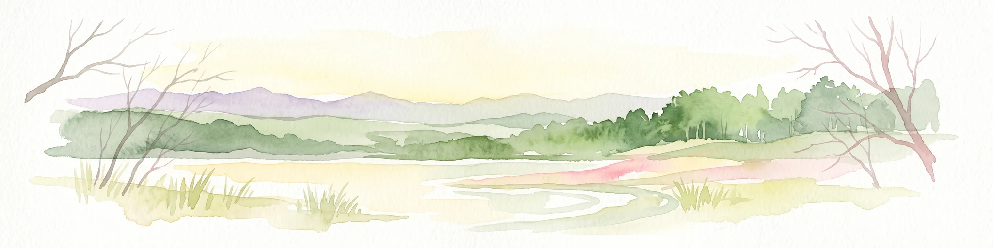
A watercolor painting showing a soft, peaceful landscape with bare trees in the foreground, green trees in the midground, and distant hills under a pale sky.
Nature reserveNorth Rhine-Westphalia
About 14 km away#1 closest

East

Kampeters Kolk Nature Reserve: Geographic Overview and Protected Wetland Boundaries

Senne region heath pond and wetland mosaic in North Rhine-Westphalia

Kampeters Kolk preserves a significant fragment of the historic Senne heath landscape in North Rhine-Westphalia. The reserve centers on a small, artificial pond created by peat extraction, now surrounded by a rich sequence of sedges, reed stands, and willow-alder shrub thickets that provide critical habitats for local amphibian populations.

Area
0.02 km²
Established
1993
IUCN
IV
Watercolor painting of soft, rolling green hills and a gentle mountain silhouette against a pastel sunrise sky.
Nature reserveNordrhein-Westfalen
About 14 km away#2 closest

North

Knüll-Storkenberg Nature Reserve: Mapping the Protected Terrain of the Teutoburg Forest

A diverse protected landscape of forest, spring-fed valleys, and grassland

Knüll-Storkenberg stands as a protected nature reserve in Nordrhein-Westfalen, encompassing a range of habitats from beech forests to sedge-filled valley meadows. This area integrates an abandoned limestone quarry into its managed landscape, creating a varied microclimate that supports distinct plant and animal communities. Its geography is anchored by the Knüll and Storkenberg hills, connected by the Wiesental valley.

Area
0.789 km²
Established
2001
IUCN
IV
A soft watercolor painting depicting a marshy wetland with green meadows, tall grasses, and distant rolling hills on a white background.
Nature reserveKreis Gütersloh
About 14 km away#3 closest

Southeast

Im Binner Nature Reserve: Geographic Overview of the Ems Sand Plain Protected Landscape

Mapped wetlands and meadow habitats in Kreis Gütersloh, Germany

Im Binner is a defined nature reserve that anchors a fragment of the historic Ems sand plain ecosystem. This site encompasses a distinctive mix of wet grasslands, shrub-lined boundaries, and converted aquatic habitats, serving as an essential ecological refuge within the intensively farmed lowland geography of North Rhine-Westphalia.

Area
0.3 km²
Established
1988
IUCN
IV
Watercolor painting of a rolling forested landscape with hills and a central water feature, stylized with soft green and peach tones.
Nature reserveNorth Rhine-Westphalia
About 18 km away#4 closest

North

Johannisegge-Schornstein Nature Reserve: Protected Woodland and Ridge Terrain Atlas

Exploring the Teutoburg Forest ridge geography in North Rhine-Westphalia.

Johannisegge-Schornstein stands as a vital nature reserve in Borgholzhausen, characterized by its exposed beech stands and its position on the Teutoburg Forest ridge. The reserve offers a clear look at historic coppice woodland management and local watershed geography, stretching from the rocky Bönkersche Steinbruch quarry to the prominent Luisenturm lookout point.

Area
2.255 km²
Established
2001
IUCN
IV
Relief
Mountain
A horizontal watercolor painting showing a small winding river flowing through a lush green forest with soft pink and yellow meadow areas in the foreground.
Nature reserveKreis Gütersloh
About 18 km away#5 closest

East

Holter Wald Nature Reserve: Mapping the Protected Woodland and Senne Landscape of Kreis Gütersloh

A major contiguous forest block on the eastern edge of the Westfälische Bucht

Situated in the district of Kreis Gütersloh, Holter Wald is a significant protected area defined by its sandy Senne soils and network of parallel brook valleys. The forest provides a critical lowland habitat for diverse flora and fauna, serving as a rare, large-scale woodland anchor within a largely agricultural region. Explore the terrain characteristics and ecological structure of this key North Rhine Westphalia site.

Area
6.13 km²
Established
2008
IUCN
IV
Relief
Lowland
Watercolor painting of a peaceful wetland landscape with green grassy fields, small groups of trees, and a central pond, set against a soft, pale background.
Nature reserveNordrhein-Westfalen
About 19 km away#6 closest

Southeast

Rietberger Emsniederung mit Steinhorster Becken: Geography and Nature Reserve Atlas

Protected floodplain habitats in North Rhine-Westphalia

Situated along the upper Ems river, this protected area serves as an essential ecological corridor. Examine the mapped extent of its wet meadows, basin structures, and riverine channels that distinguish this region from the surrounding agricultural landscape.

Area
9.28 km²
Established
2000
Relief
Lowland
Climate
Temperate
Nature reserveNordrhein-Westfalen
About 21 km away#7 closest

South

Märzenbecherwald Nature Reserve: Wetland Mosaic and Protected Forest in Nordrhein-Westfalen

A rare calcareous fen and alder swamp forest ecosystem

This protected nature reserve in the Warendorf district serves as a vital ecological anchor, preserving a mosaic of spring-fed seeps, damp woodlands, and calcareous fens. Despite its modest size, the area provides a sharp contrast to the surrounding agricultural fields of the Münsterland region, maintaining a essential water-logged habitat for specialized plant species.

Area
0.016 km²
Established
1995
IUCN
IV
Relief
Lowland
A watercolor painting of a wetland landscape with soft green hills, trees, and a winding waterway.
Nature reserveNorth Rhine-Westphalia
About 22 km away#8 closest

East

Kipshagener Teiche Nature Reserve: A Protected Wetland Sanctuary in North Rhine-Westphalia

Geographic analysis of historic bogs and managed wetland habitats

Kipshagener Teiche is a small but essential nature reserve in the Senne region, characterized by a distinct mosaic of ponds, transitional bog, and wet heath. Originally protected in 1937, the site serves as a vital record of wetland biodiversity and recovery in western Germany. Its varied topography, featuring dune-based pine plantations and swamp forest, offers a precise look at the intersection of conservation and landscape management in a human-influenced region.

Area
0.113 km²
Established
1970
IUCN
IV

Common questions about visiting, size, designation, and location context for Hühnermoor

Hühnermoor FAQs for park facts, access, geography, and protected area context

Find quick answers about Hühnermoor, including protected-area facts, park geography, trail and visitor context, and how the park fits into its surrounding country and regional landscape.
MoriAtlas Explorer

Continue Your Protected Areas Search Across the Global Atlas

Deepen your exploration by continuing the structured search for national parks and protected areas worldwide. Utilize the comprehensive filtering capabilities to compare different conservation landscapes and refine your understanding of global park geography. Discover more about the distribution and characteristics of protected natural areas.

Global natural geography