
Mori Atlas logo
Nature reserveHürther Waldsee

Geographic analysis of reclaimed post-mining landscapes, waterbird refuges, and mixed woodland terrain

Hürther Waldsee Nature Reserve: A Mapped Protected Area in the Nordrhein-Westfalen Region

(Naturschutzgebiet Hürther Waldsee)

Hürther Waldsee serves as a key case study in ecological reclamation within the Nordrhein-Westfalen mining district. This protected area on the Ville lake plateau demonstrates the successful conversion of industrial terrain into a vital waterbird refuge and woodland ecosystem. The surrounding map features show intentional habitat engineering, including reed beds and shallow water zones, which support diverse flora and fauna within the reclaimed landscape.

nature reservepost-mining lakelignite reclamationVille lake plateauwetland habitatreed beds
A stylized flat vector illustration of a valley with mountains, a prominent waterfall, a winding river, and pine trees in the foreground.

Hürther Waldsee

Nature reserve

Park overview

Structured park overview, official facts, and landscape profile for Hürther Waldsee

Hürther Waldsee park facts, protected area profile, and essential visitor context

Review the core facts for Hürther Waldsee, including designation, size, terrain, visitor scale, habitats, and operating context in one park-focused overview.

About Hürther Waldsee

Hürther Waldsee is a small protected lake in the Rhineland lignite mining region whose existence is tied closely to the history of industrial land use and subsequent reclamation. Like the many other lakes of the Ville, it was not formed by natural geological processes but by the gradual filling of an opencast mining hole with rising groundwater once coal extraction on the Theresia field had finished. The lake first filled in 1988, making it one of the most recent additions to the Ville lake plateau, a roughly fifty square kilometre mosaic of mixed woodland and more than forty lakes south of Cologne.

Although only about ten hectares in size, the lake has been treated as a conscious ecological design from the beginning. Engineers and landscape planners incorporated biotope structures into the body of water, including an underwater dam, two islands, several shallow water zones, and small ponds. The intention was to create a richly structured habitat even before the surrounding vegetation had matured, and to support colonising species of birds, amphibians, and aquatic invertebrates. The decision to keep the water level constant, rather than lowering it during migration periods, has favoured the development of dense reed beds, which in turn benefit species that depend on this habitat.

The wider setting is also important for understanding the lake. Hürth lies in the Rhein-Erft-Kreis, and the Ville lake plateau falls partly within the Naturpark Rheinland. The lake is reached only by a forest path at its northern edge, and access is intentionally limited in order to minimise disturbance to breeding and resting birds. This quieter, more restricted character distinguishes Hürther Waldsee from the much larger Otto-Maigler-See that lies immediately to its east, which is oriented around recreation and tourism. Together, the two lakes illustrate two different but complementary approaches to the post-mining landscape: one prioritising public use, and the other prioritising ecological recovery.

Quick facts and research context for Hürther Waldsee

Hürther Waldsee is a 10.6 hectare post-mining lake in North Rhine-Westphalia, situated within the city limits of Hürth in the Rhein-Erft-Kreis and roughly within the Naturpark Rheinland. It lies on the northern edge of the Ville lake plateau, near the Otto-Maigler-See and not far from the former Cistercian convent of Marienborn. The lake is approximately 680 metres long and 260 metres wide, with a maximum depth of about eight metres, and was formed in 1988 when groundwater filled the residual hole of the closed Theresia lignite mine. The entire lake and its surrounding young beech and alder woodland are designated as a nature reserve, giving it a stronger conservation focus than the recreational lakes around it.

Protection and recognition

Analysis of terrestrial conservation scope and official records

Hürther Waldsee Protection Status and Documented Area Records

Terrestrial protection status for Hürther Waldsee details the documented management scope across the protected landscape. Official records compile conservation designations without assuming international recognition frameworks.

Protection details

Protection scope
Terrestrial
Park context

Deeper park guide and search-rich context for Hürther Waldsee

Hürther Waldsee history, landscape, wildlife, and travel context

Explore Hürther Waldsee through its history, landscape character, ecosystems, wildlife, conservation priorities, cultural context, and seasonal travel timing in a structured park guide built for atlas discovery and search intent.

Why Hürther Waldsee stands out

Hürther Waldsee is best known as a nature reserve lake set within a reclaimed former lignite mining area. Its defining character is the combination of an artificially structured lake body, with engineered islands, shallow water zones, reed beds, and an underwater dam, and the surrounding young mixed forest that has grown up on the reclaimed terrain. The lake is particularly valued as a refuge for waterbirds near the popular Otto-Maigler-See, making it one of the most ecologically important small lakes on the Ville lake plateau.
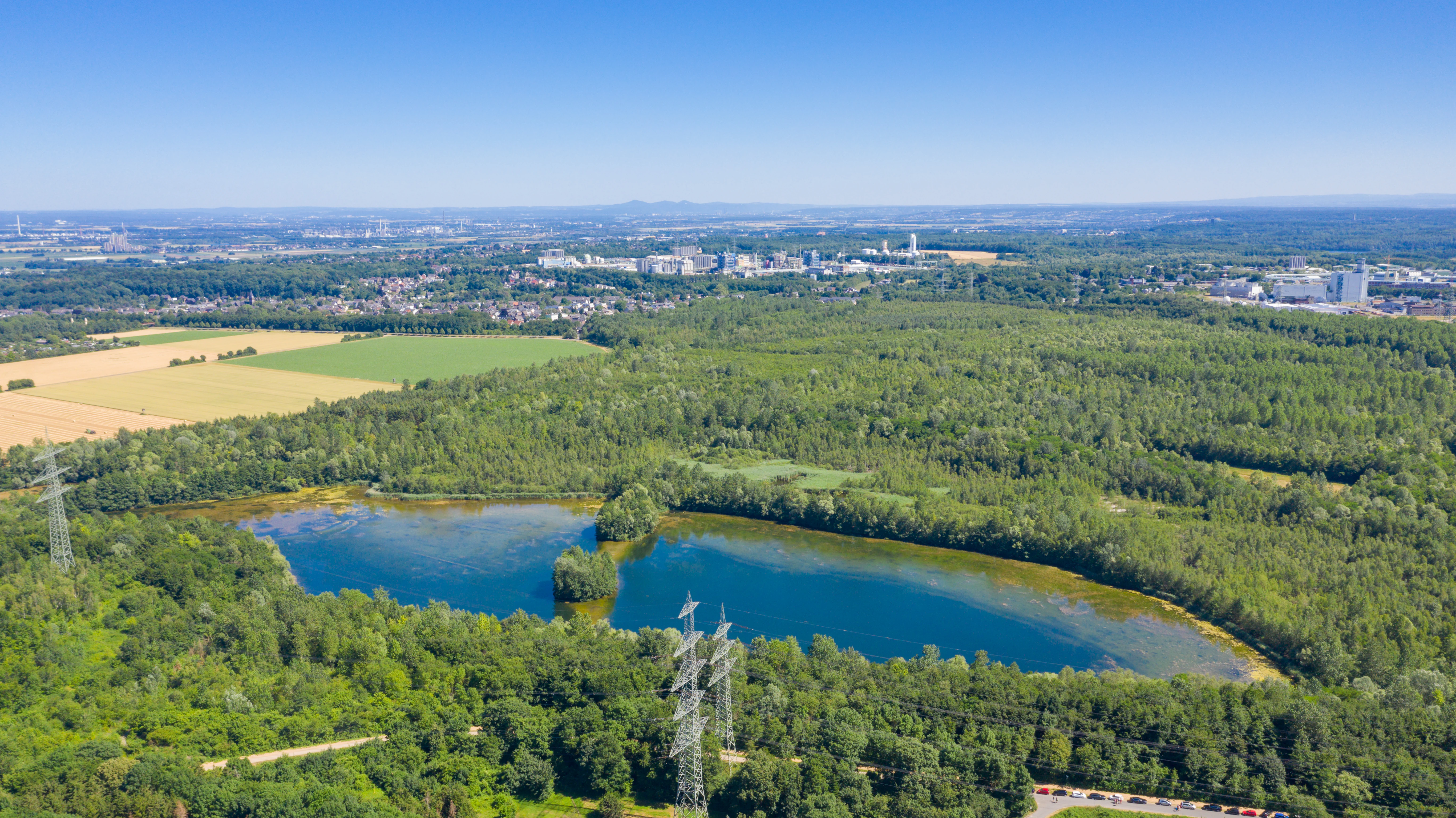
An aerial drone view showing a small blue lake nested within a dense green forest, with power line towers in the foreground and urban industrial buildings in the background.
Aerial view of the Hürther Waldsee, a post-mining lake surrounded by forest in Hürth, Germany.

Hürther Waldsee history and protected-area timeline

The history of Hürther Waldsee is inseparable from the history of lignite mining in the southern Rhineland. The Theresia mining field was worked between 1965 and the early 1980s, after which the opencast pit was abandoned as a deep residual hole in the landscape. Following the end of extraction, groundwater rose and gradually filled the depression, creating the lake that exists today. Compared to many older Ville lakes, the Waldsee is a relatively young body of water, having only reached its present form in 1988.

From the start, the former mining area was not simply left to fill passively. It was incorporated into the broader reclamation programme of the Rhineland lignite district, which transformed exhausted opencast pits into a planned landscape of forests, farmland, and lakes. The Theresia site was designed with explicit nature conservation goals, and the resulting lake was quickly placed under formal nature reserve protection. Regional planning documents for the Cologne administrative region subsequently identified the area as a particularly valuable breeding and resting site for endangered waterbirds, and outlined long-term measures aimed at designating it as a European Habitats Directive area, linked to the larger RegioGrün initiative for green corridors in the region.

Since the 1990s, the lake has also been the subject of a long-term study by the North Rhine-Westphalian state institute for ecology, land management, and forestry, tracking the natural succession of fish populations in reclaimed waters. This has made Hürther Waldsee not only a nature reserve but also a reference site for understanding how aquatic ecosystems recover in former mining landscapes.

Hürther Waldsee landscape and geographic character

The landscape of Hürther Waldsee sits on the northern edge of the Ville lake plateau, a broad swathe of reclaimed terrain south of Cologne where former lignite mines have been converted into a patchwork of woodland and water. The lake itself occupies a relatively flat, shallow basin in the reclaimed Theresia field, framed by gently rising forested ground. Its outline is irregular, defined by a length of about 680 metres and a width of roughly 260 metres, and includes engineered peninsulas and two small islands that give its shoreline a varied, indented form.

Surrounding the lake is a young, still-developing mixed woodland. Beech and alder dominate, with scattered birch and other broadleaved trees filling in the gaps. Because the forest has only had a few decades to establish on former mining soil, it has the character of vigorous early-succession woodland, with dense understorey growth and a relatively simple vertical structure. Walking paths thread through the trees but stop well short of the shoreline, leaving most of the lake margin undisturbed.

A defining feature of the wider area is the contrast between this quiet, conservation-oriented lake and its larger, much more intensively used neighbour, the Otto-Maigler-See. Together they sit at the edge of a larger network of similarly reclaimed lakes and forests that stretches southward through the Ville, forming one of the most distinctive man-made natural landscapes in western Germany.
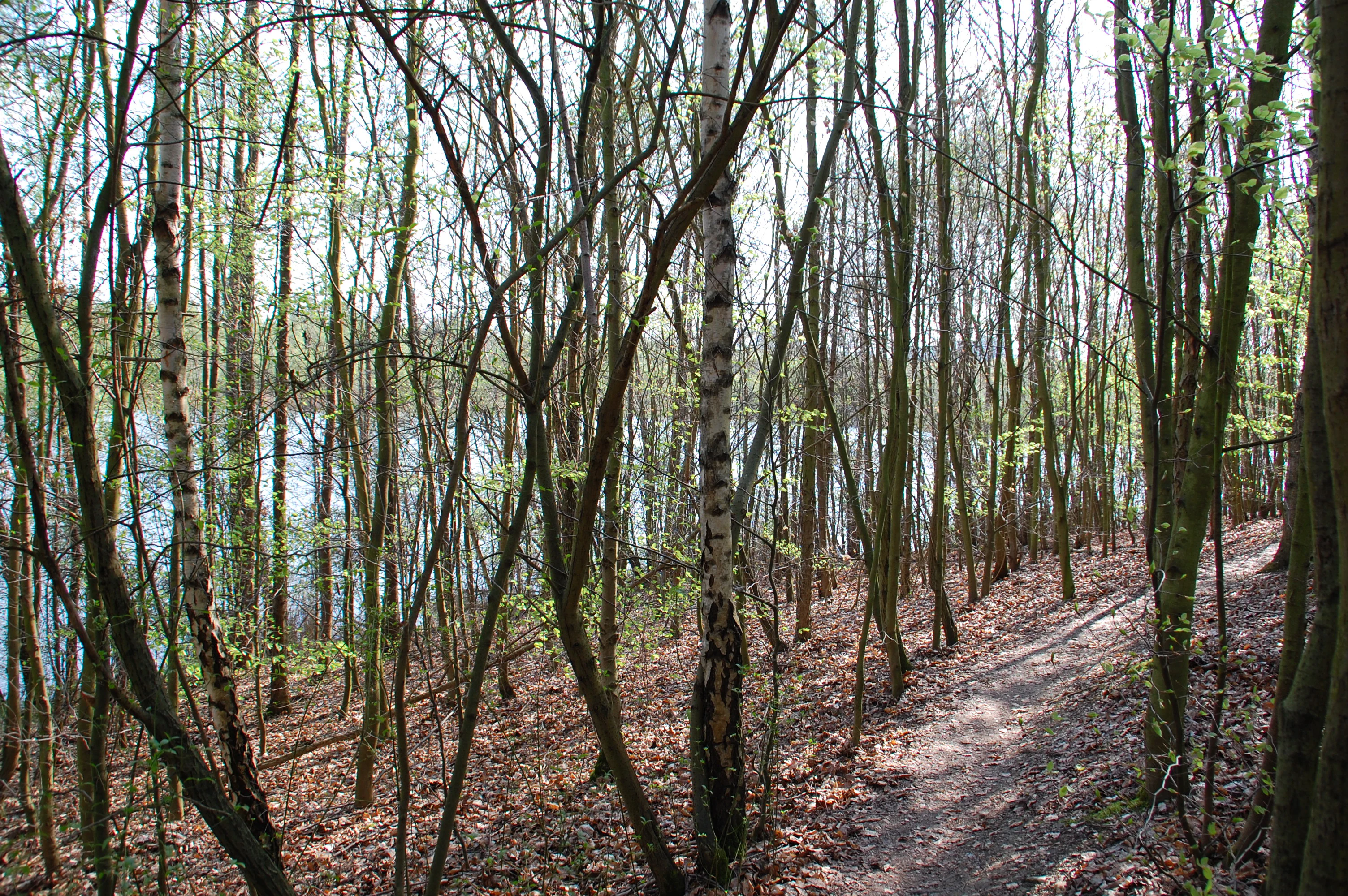
A narrow dirt path through a forest of thin deciduous trees with white and grey bark, with a glimpse of a lake visible through the tree trunks in the background.
A narrow dirt trail winding through a birch forest overlooking Hürther Waldsee.

Hürther Waldsee ecosystems, habitats, and plant life

Ecologically, Hürther Waldsee is a textbook example of a designed post-mining habitat. The lake was created not out of natural geological processes but through deliberate reclamation and ecological engineering, and its nature reflects that origin. Its shoreline includes shallow water zones, reed beds, and small ponds, and an underwater dam creates differentiated depth zones and helps maintain the reed belt. These structures were specifically intended to accelerate ecological succession by providing niches for waterbirds, amphibians, and aquatic invertebrates within a young lake that would otherwise offer relatively uniform habitat.

The reed beds in particular have become a defining ecological feature. Originally, planners had intended to lower the water level during migration periods to expose additional mudflats, but they abandoned that approach because the reed grew so strongly that stable water levels were preferred. Today, dense stands of common reed fringe much of the shoreline, offering cover for nesting and roosting birds.

The surrounding young mixed forest adds a second habitat layer. Beech and alder provide the framework, with birch and other broadleaved species adding diversity. Although the woodland is still relatively immature, it already supports a varied ground flora, including rare species such as the bee orchid, and provides roosting habitat for bats. The overall nature of the area is therefore one of a young but rapidly maturing post-industrial ecosystem, where both aquatic and terrestrial habitats are developing in tandem.

Hürther Waldsee wildlife and species highlights

Hürther Waldsee is primarily valued for its birdlife, and the lake is recognised as an important refuge for waterbirds in the Rhine-Erft region. The combination of open water, shallow margins, reed beds, and two small islands creates a varied habitat that supports both breeding and migratory species. Its protected status and limited public access make it especially attractive to waterfowl seeking undisturbed resting sites, in contrast to the heavily used Otto-Maigler-See next door.

Bats are another important component of the wildlife record. The Noctule bat, a species on Germany's Red List, has been documented around the lake, in addition to records from the Sophienhöhe at the Hambach mine. Invertebrate diversity is also notable. Freshwater snails and mussels, water bugs, water beetles, and butterflies have been recorded in and around the lake, along with two grasshopper species of conservation concern: the long-horned bush-cricket and the blue-winged locust.

Fish populations have been studied systematically since the 1990s as part of a long-term investigation by the North Rhine-Westphalian state institute for ecology into how fish communities naturally colonise reclaimed mining waters. Although specific species are not the focus of the lake's conservation story, the long-running monitoring has made the Waldsee one of the better-documented small post-mining lakes in the Rhineland from a fisheries and aquatic ecology perspective.

Hürther Waldsee conservation status and protection priorities

Conservation lies at the core of Hürther Waldsee's identity, more so than for almost any other lake on the Ville lake plateau. The entire lake and its surrounding forest were placed under nature reserve protection soon after the lake formed, with the explicit statutory aim of restoring habitats for specific wild plant and animal species. Within a few years of designation, several protected species had been recorded, and the site has continued to act as a refuge for waterbirds in a region where recreational pressure on other lakes is high.

The conservation framework stretches beyond regional protection. Planning documents for the Cologne administrative region describe the area as an exceptionally valuable breeding and resting site for endangered waterbirds, with the goal of preserving it and allowing it to develop naturally with minimal intervention. There are also plans, advanced through the RegioGrün initiative, to develop the area toward a European Habitats Directive site, which would anchor it within the EU-wide Natura 2000 network of protected areas.

In parallel with these formal protection measures, the lake serves as a long-term ecological research site. Since the 1990s, regular fish surveys have been carried out by the state institute for ecology, land management, and forestry, contributing to broader scientific understanding of how biodiversity returns to reclaimed mining landscapes.

Hürther Waldsee cultural meaning and human context

Hürth and the surrounding Ville region carry a layered cultural identity shaped by both older religious and rural traditions and the more recent industrial history of lignite mining. Near the lake lies the former Cistercian convent of Marienborn in Hürth-Burbach, a reminder of the longer monastic and agricultural heritage of the area before modern mining transformed the landscape. The villages of Knapsack to the south and Alstädten-Burbach to the north once sat within an agricultural and small-scale industrial setting that was progressively reshaped by the opencast works.

In the late twentieth and early twenty-first centuries, the cultural narrative of the region shifted toward managed landscape transition. Former mining settlements and pits have been consciously reinvented as nature reserves, recreational lakes, and leisure destinations, and Hürther Waldsee fits within this broader story. Rather than being treated as a relic of industrial damage, the lake is presented as an intentional outcome of reclamation, a place where ecological and cultural recovery go hand in hand. This dual narrative, of older rural and monastic heritage layered beneath a modern industrial and post-industrial landscape, gives the region around the lake a distinct sense of place within the Rhineland.

Top sights and standout views in Hürther Waldsee

Hürther Waldsee stands out among the lakes of the Ville for its emphasis on ecological recovery rather than recreation. The combination of an engineered lake design with two islands, an underwater dam, shallow water zones, and reed beds makes it unusually habitat-rich for a lake of only ten hectares. It is one of the most recent lakes on the Ville lake plateau, having filled with groundwater in 1988, and yet it has already become one of the region's most important protected waterbird refuges.

Equally notable is the lake's role as a long-term ecological study site, with systematic fish monitoring since the 1990s and ongoing plans to anchor it within the wider European network of Habitats Directive areas. Together with the surrounding young mixed forest of beech and alder, the lake offers a compact but information-dense example of how a former industrial site can be transformed into a functioning nature reserve.

Best time to visit Hürther Waldsee

As a strictly protected nature reserve with only limited public access, Hürther Waldsee is primarily a site for quiet observation rather than active recreation. The broad seasonal pattern follows that of the wider Ville landscape, with late spring and early summer generally the most rewarding period for visiting woodland and wetland habitats in the region, when reed beds are in full growth, bird activity around breeding sites is at its peak, and woodland ground flora is most visible.

Migratory waterbirds tend to use the lake in spring and autumn, when the combination of stable water levels and undisturbed shoreline can attract transient species. Outside these peak wildlife periods, the lake and its surrounding young forest remain pleasantly quiet and atmospheric year round, though visitors should keep in mind that access to the shoreline itself is restricted to protect the site, and the lake is best appreciated from the surrounding paths rather than as a destination in its own right.


Monthly climate preview

Long-term representative averages tracking monthly temperature and precipitation rhythm

Hürther Waldsee Climate Normals and Annual Temperature Patterns

Historical measurements from 1991 to 2020 outline the measured baseline temperature range and precipitation rates recorded at Hürther Waldsee coordinates. Detailed monthly normals clarify the full annual climatology progression across all twelve periods.
Annual mean10 °C
1 °C19 °C
Jan
Feb
Mar
Apr
May13°
Jun17°
Jul19°
Aug19°
Sep15°
Oct10°
Nov
Dec
Warmest month
July

19.2 °C

Coolest month
January

1.3 °C

Wettest month
December

2.6 mm/day

Driest month
April

1.6 mm/day

Park location guide

Geography guide, regional context, and park location map for Hürther Waldsee

Hürther Waldsee park geography, regions, and map view in Germany

Understand where Hürther Waldsee sits in Germany through a broader geographic reading of the surrounding landscape, nearby location context, and its mapped position within the national park landscape.

How Hürther Waldsee fits into Germany

Germany is a federal republic in Western and Central Europe with a population of over 83 million across sixteen constituent states. It is Europe's largest economy by nominal GDP and a major global exporter and importer. The capital is Berlin, and the country borders Denmark, Poland, Czech Republic, Austria, Switzerland, France, Luxembourg, Belgium, and the Netherlands.

Wider geography shaping Hürther Waldsee in Germany

Germany is located in Western and Central Europe, spanning 357,022 km². It borders Denmark to the north, Poland and the Czech Republic to the east, Austria and Switzerland to the south, and France, Luxembourg, Belgium, and the Netherlands to the west. The country has coastlines on the Baltic Sea and North Sea to the north, with the Alps located in the southern region.

Map view of Hürther Waldsee

Use this park location map to pinpoint Hürther Waldsee in Germany, understand its exact geographic position, and read its mapped placement within the surrounding landscape more clearly.

Pigeon | © OpenStreetMap contributors

Location context for Hürther Waldsee

Nordrhein-Westfalen

Explore detailed imagery of the mixed woodland, engineered shorelines, and waterbird habitats.

Hürther Waldsee Photos and Landscapes, Visualizing the Protected Post-Mining Lake

Visual records illustrate the unique terrain and ecological restoration of Hürther Waldsee across the Ville lake plateau. Photographic documentation reveals the sheltered wetland features and recovering forest habitats that define the protected reserve.

An aerial drone view showing a small blue lake nested within a dense green forest, with power line towers in the foreground and urban industrial buildings in the background.

A calm lake with a treeline of green deciduous trees reflecting in the water; industrial smokestacks and power lines are visible in the distance under a pale blue sky.

A narrow dirt path through a forest of thin deciduous trees with white and grey bark, with a glimpse of a lake visible through the tree trunks in the background.

Park atlas

Compare adjacent wetland habitats and reclaimed nature reserves across the Ville lake plateau.

Parks Near Hürther Waldsee: Explore Other Protected Areas and Regional Landscapes

Visitors exploring Hürther Waldsee can continue discovering other protected areas and nearby lakes throughout the surrounding regional landscape. Comparing adjacent post-mining nature reserves reveals distinct ecological patterns across the broader western German conservation network.
A horizontal watercolor painting depicting a gentle, hazy green landscape with rolling hills, a line of trees, and a foreground meadow.
Protected landscapeNorth Rhine-Westphalia
Mapped location lies within the park boundary#1 closest

South

Naturpark Rheinland: Geography and Protected Area Overview in North Rhine-Westphalia

A complex metropolitan nature park and lake district

Naturpark Rheinland represents a distinct convergence of reclaimed lignite mining landscapes, quiet lowland forests, and floodplain wetlands. Its mapped boundaries reveal a diverse terrain of ridges and river valleys that define the environmental character of the Cologne-Bonn metropolitan region.

Area
1,045 km²
Established
1959
Relief
Upland
Climate
Temperate
A horizontal watercolor painting depicting a calm lake surrounded by low, rolling hills and coniferous trees under a soft, pale sky.
Nature reserveNordrhein-Westfalen
About 5.2 km away#2 closest

South

Heider Bergsee Nature Reserve: Geographic Context and Protected Landscape Map

A recovered lake landscape in the North Rhine-Westphalia region of Germany

Discover the complex geography of Heider Bergsee, a prominent nature reserve and post-mining lake in the Ville region. This area showcases how nutrient-poor water and managed forest edges create a vital ecosystem within North Rhine-Westphalia, providing a distinct study in landscape restoration and protected-area mapping.

Area
0.354 km²
Established
1965
Relief
Lowland
Climate
Temperate
A soft watercolor illustration of a serene pond surrounded by gentle green hills and lush shoreline vegetation in a light, pastel color palette.
Nature reserveCologne
About 6.9 km away#3 closest

East

Kiesgruben Meschenich: Geographic Analysis of a Cologne Nature Reserve Landscape

Examining the ecological terrain and mapped gravel-pit habitat network.

Kiesgruben Meschenich offers a distinct study in regional conservation, presenting a complex of excavation lakes, raw gravel substrates, and wetland fringes. This protected area stands as a primary example of how industrial remnants transform into valued ecological hubs, serving as a critical refuge for biodiversity in the densely populated Rhine landscape of North Rhine-Westphalia.

Area
0.265 km²
Established
1991
Relief
Lowland
Scope
Terrestrial
Watercolor landscape illustration showing a pale river curving through green trees with soft hills in the distance.
Nature reserveNorth Rhine-Westphalia
About 11 km away#4 closest

East

Langeler Auwald: A Protected Floodplain Forest in the North Rhine-Westphalia Rhine Corridor

Examining fluvial landscape patterns and riparian forest boundaries

Langeler Auwald functions as a significant nature reserve on the right bank of the Rhine in Cologne, preserving a rare mosaic of willow-poplar floodplain forest. The terrain encompasses periodically flooded gravel shores, nutrient-poor grasslands on flood dikes, and transitional orchard habitats that support a high density of protected species within the urbanized landscape of North Rhine-Westphalia.

Area
0.224 km²
Relief
Lowland
Climate
Temperate
Scope
Terrestrial
A soft, pale watercolor illustration of a lake with small islands and a low, distant treeline.
Nature reserveNorth Rhine-Westphalia
About 14 km away#5 closest

East

Kiesgrubensee Gremberghoven Nature Reserve Geographic and Protected Area Overview

A restored industrial gravel pit ecosystem in North Rhine-Westphalia.

Kiesgrubensee Gremberghoven functions as a protected nature reserve in the Cologne metropolitan area. The site is defined by its origin as a former gravel excavation, now containing a substantial lake that attracts waterbirds and supports cliff-nesting colonies along its steep sandy slopes. This location serves as an informative case study for understanding how industrial remnants in German landscapes can be rehabilitated for conservation and ecological study.

Area
0.377 km²
Established
1989
Relief
Lowland
Climate
Temperate
A watercolor illustration of a gentle, winding stream through a green, hilly valley with deciduous and coniferous trees, against a background of soft, blue-toned mountains.
Nature reserveNordrhein-Westfalen
About 15 km away#6 closest

Northwest

Kernzone Ommelstal: Geographic Overview of the Protected Nature Reserve in Germany

A stream-valley mosaic within the Nordrhein-Westfalen loess plains.

Kernzone Ommelstal acts as a localized sanctuary of wet woodlands, ponds, and marshy ground situated in the fertile farming landscapes of Nordrhein-Westfalen. This 14-hectare reserve serves as a critical study of how small-scale landscape incisions, shaped by the Fliestedener Bach, create essential niches for habitat protection in intensively cultivated regions.

Area
0.143 km²
Established
2017
IUCN
IV
Nature reserveCologne
About 17 km away#7 closest

East

Kiesgruben Paulsmaar Nature Reserve: Landscape and Geography in the Cologne Urban Fringe

A managed mosaic of post-industrial gravel pits and wetland habitats.

Kiesgruben Paulsmaar represents a distinct example of urban-edge habitat restoration in western Germany. Located near the border of Cologne, this 24-hectare nature reserve consists of three interconnected water bodies, floodplain forests, and calcareous grasslands. It serves as a regional refuge for biodiversity while documenting the conversion of former industrial land into a functioning wetland ecosystem.

Area
0.247 km²
Established
1991
Relief
Lowland
Climate
Temperate
A soft watercolor illustration showing a peaceful landscape with gentle hills, trees, and small ponds reflecting light.
Nature reserveNordrhein-Westfalen
About 17 km away#8 closest

Southeast

Quarzsandgrube Nature Reserve: Geographic Profile and Protected Landscape Context

Protected mosaic of pioneer habitats in the Rhein-Sieg-Kreis

Located on the terrace slopes of the Rhein-Sieg-Kreis, Quarzsandgrube represents a significant refuge for early successional flora and fauna. The site features an uneven terrain of exposed sandy soils and water-filled hollows, providing a vital habitat corridor alongside adjacent protected areas. This detailed geographic profile maps the environmental conditions that define its current status as a protected nature reserve.

Area
0.29 km²
Established
1994
IUCN
IV

Common questions about visiting, size, designation, and location context for Hürther Waldsee

Hürther Waldsee FAQs for park facts, access, geography, and protected area context

Find quick answers about Hürther Waldsee, including protected-area facts, park geography, trail and visitor context, and how the park fits into its surrounding country and regional landscape.
MoriAtlas Explorer

Continue Your Protected Areas Search Across the Global Atlas

Deepen your exploration by continuing the structured search for national parks and protected areas worldwide. Utilize the comprehensive filtering capabilities to compare different conservation landscapes and refine your understanding of global park geography. Discover more about the distribution and characteristics of protected natural areas.

Global natural geography