Mori Atlas logo
Protected areaHüttruper Heide

A rare remnant of historic Westfalian heathland containing juniper stands and sensitive wetland habitats.

Hüttruper Heide Protected Area: Mapped Geography and Heathland Landscapes in Germany

(Naturschutzgebiet Hüttruper Heide (ST-011))

Hüttruper Heide stands as a significant protected landscape within the Münsterland region of Germany. This site preserves a rare combination of dry juniper-dominated heath and wet depressions, providing critical habitat for threatened flora such as the marsh gentian. Its mapped boundaries offer a stark contrast to the surrounding agricultural and infrastructure developments in the Greven district.

lowland heathjuniper heathdry heathwet heathmarsh gentian habitatnature reserve

Hüttruper Heide

Protected area

Park overview

Structured park overview, official facts, and landscape profile for Hüttruper Heide

Hüttruper Heide park facts, protected area profile, and essential visitor context

Review the core facts for Hüttruper Heide, including designation, size, terrain, visitor scale, habitats, and operating context in one park-focused overview.

About Hüttruper Heide

Hüttruper Heide is a small nature reserve in the Münsterland that protects a remnant of a once extensive lowland heathland. Although the protected area covers only about 12.3 hectares, the site carries substantial regional significance because most of the surrounding historic heath has long since been converted to farmland or forest plantations. The reserve preserves the character of both dry and damp heath in close proximity, making it a useful, if compressed, cross-section of Westmünsterland heath ecology.

The reserve sits in the Greven district of Hüttrup, in the northwestern part of North Rhine-Westphalia, and is geographically framed by the Eltingmühlenbach to the southwest, the Ladberger Mühlenbach to the north, and the Dortmund-Ems-Kanal to the east. Its small footprint contrasts with the scale of its ecological and cultural meaning, as the surviving vegetation still reflects centuries of grazing-driven open heath once typical across the region.

Protection was first established in 1938, putting the surviving core under formal Naturschutz status. The site is registered as ST-011 in the North Rhine-Westphalia Fachinformationssystem for protected areas. Despite its long protection history, the reserve currently faces strong pressure from the adjacent Münster-Osnabrück (FMO) airport and the Airportpark business development, where structural planning has explicitly contemplated the destruction of the protected area, and where nearby roads and development have already degraded surrounding buffer land and small breeding pools.

Ecologically, the reserve offers two clearly differentiated zones worth visiting for anyone interested in the Westphalian heath mosaic: a drier juniper-rich ridge and a wet, molinia-dominated depression that holds water in winter. Together they support a concentration of plant species, including several regionally threatened ones, far higher than the reserve's tiny size would suggest. The site is therefore often discussed as a classic small-scale refuge with an outsized botanical and ornithological footprint.

Quick facts and research context for Hüttruper Heide

Hüttruper Heide is a designated nature reserve (Naturschutzgebiet) in the city of Greven, within Kreis Steinfurt, North Rhine-Westphalia. It was placed under formal protection in 1938, protecting only about 12.3 hectares of what was once a far larger heathland landscape.

The reserve has two distinct sections: a dry juniper strip in the northeast and a damp, molinia-filled depression bordered partly by pine forest in the southwest. It lies between the Eltingmühlenbach, Ladberger Mühlenbach, and the Dortmund-Ems-Kanal. A documented 1992 count of over 1,000 marsh gentians and at least 25 threatened plant species underline its botanical significance.

Protection and recognition

Explore terrestrial protection metrics and official designation records for Hüttruper Heide.

Hüttruper Heide Protection Status and Documented Conservation Scope

Terrestrial protection status and designation details provide clear context for understanding the conservation framework governing Hüttruper Heide. Structured preservation records outline management scope and international recognition guidelines across the protected landscape.

Protection details

Protection scope
Terrestrial
Transboundary protection
No
Park context

Deeper park guide and search-rich context for Hüttruper Heide

Hüttruper Heide history, landscape, wildlife, and travel context

Explore Hüttruper Heide through its history, landscape character, ecosystems, wildlife, conservation priorities, cultural context, and seasonal travel timing in a structured park guide built for atlas discovery and search intent.

Why Hüttruper Heide stands out

Hüttruper Heide is best known as a tiny but botanically important remnant of the Westfalian heath landscape, particularly for its old juniper stand and its population of the rare marsh gentian (Gentiana pneumonanthe). The reserve holds one of the largest known occurrences of this strongly threatened species in Kreis Steinfurt. It is also notable as an example of how a once extensive heathland has been reduced to a fragment, and as a case study in the pressures that infrastructure development places on small surviving protected sites in the Münsterland region.
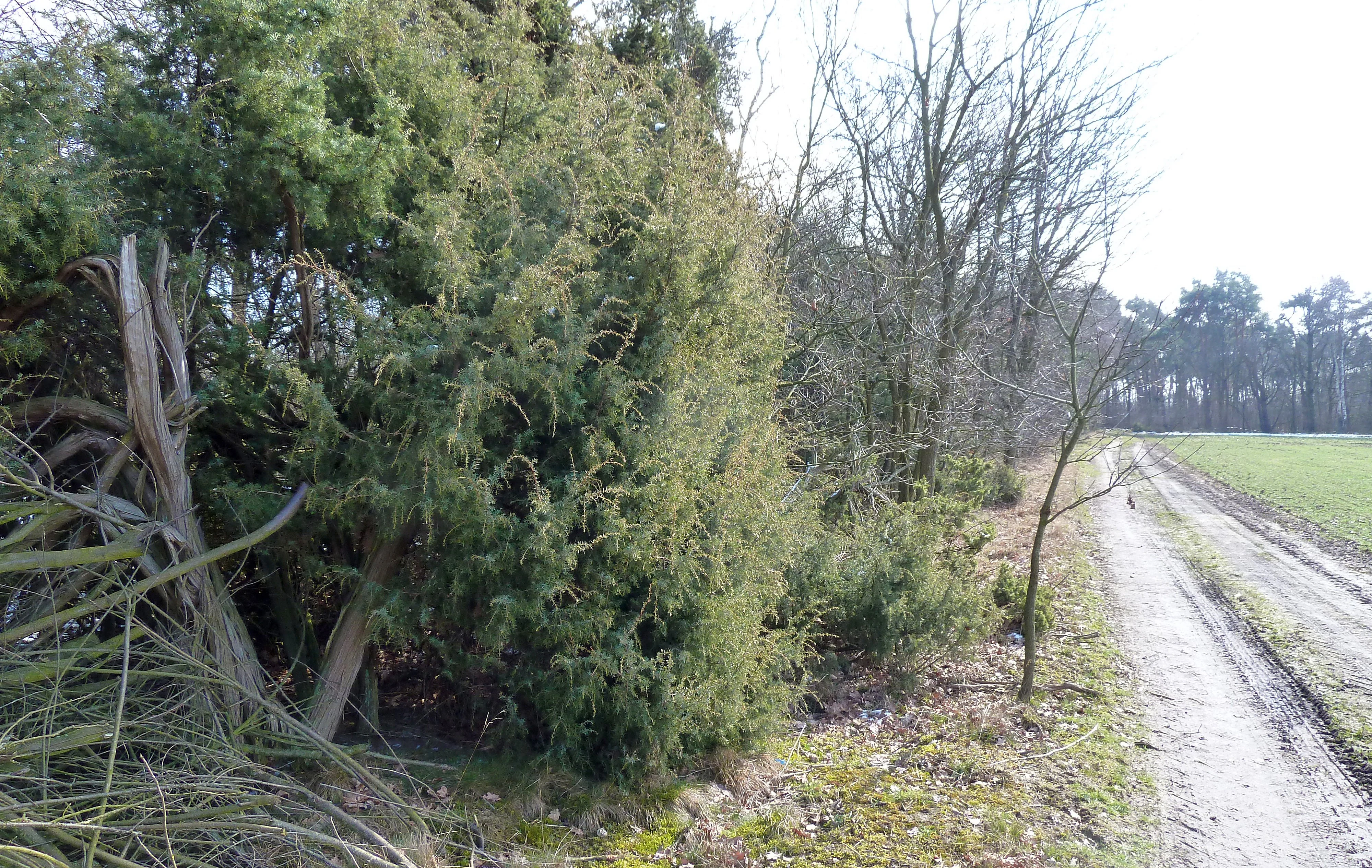
A dirt path runs alongside dense green juniper bushes and bare trees in a nature reserve landscape.
A sandy path winds past juniper bushes in the Hüttruper Heide nature reserve.

Hüttruper Heide history and protected-area timeline

The Hüttruper Heide was not established as a new entity in the twentieth century, but rather survives as one of the last unprotected, or at least once unprotected, fragments of a heathland that once stretched across the Greven area. Over the course of the late nineteenth and twentieth centuries, most of these open heaths were ploughed up, afforested, or otherwise taken out of the traditional grazing cycle that had maintained them.

Formal conservation action came in 1938, when 12.3 hectares of the surviving heath were placed under Naturschutz protection, becoming part of the regional network of protected sites in what is now Kreis Steinfurt. The earliest written documentation of its significance appears in Fritz Runge's inventories of Westphalian nature reserves and natural monuments of the Kreis Steinfurt area in the early 1980s, which describe the site and its characteristic plant communities.

Subsequent decades have brought growing external pressure. In the 1990s, peripheral greenland was added as a buffer zone to help protect the core area. By 2010, the development of a district road (Kreisstraße 1) connecting Münster-Osnabrück Airport directly to the Bundesautobahn 1 had already involved the deliberate degradation of nearby buffer land and the filling in of small amphibian breeding ponds called Blänken. Structural plans for the adjacent Airportpark FMO industrial area have openly envisaged the destruction of the protected area itself, with proposed replacement habitat that conservationists consider inadequate.

The contemporary history of the reserve is therefore as much about ongoing conflict with infrastructure expansion as it is about traditional protection history, and the site has become a documented local case study for the challenges of preserving very small but ecologically dense protected sites in densely developed western Germany.

Hüttruper Heide landscape and geographic character

The landscape of Hüttruper Heide is defined by a striking contrast between a narrow, drier ridge and a low-lying wet depression, both set within a broader agricultural and infrastructural setting along the Dortmund-Ems-Kanal corridor. The northeastern part of the reserve is essentially a thin wooded strip dominated by juniper, with individual junipers reaching up to about six meters in height and forming the visual signature of the reserve when viewed from the west.

The southwestern part of the site is structurally different. It contains patches of pine forest and a moist depression dominated by purple moor-grass (Molinia caerulea), which fills with standing water during the winter months. This small-scale juxtaposition of dry heath ridge, pinewood, and wet molinia hollow gives Hüttruper Heide an unusually compressed representation of Münsterland heathland landscape types within a very small area.

Surrounding the reserve, the broader landscape includes the flat lowlands around the Eltingmühlenbach, Ladberger Mühlenbach, and the Dortmund-Ems-Kanal. Historically this area would have been open heath and grazed commons; today it is dominated by fields, forestry, roads, the airport, and the Airportpark business zone, against which the small surviving heathland fragment reads as a sharp landscape contrast.

Hüttruper Heide ecosystems, habitats, and plant life

The ecological identity of Hüttruper Heide is that of a classic Westphalian lowland heath fragment, with both dry and wet expressions present in close proximity. The drier section is dominated by juniper, with an understory of wavy hair-grass (Deschampsia flexuosa), small amounts of common heather (Calluna vulgaris), sheep's fescue, and hardfern. The plant community here is heavily influenced by long-term grazing history and by ongoing encroachment from oaks, birches, and pines.

The wetter section is shaped by Molinia caerulea in a depression that becomes seasonally waterlogged. Cross-leaved heath (Erica tetralix), once common here, has become rare, but the reserve still supports the marsh gentian (Gentiana pneumonanthe), a species strongly threatened in North Rhine-Westphalia. Surveys noted more than 1,000 marsh gentian individuals in 1992, and more recent work has documented at least 25 endangered plant species within the reserve.

Small landscape features known as Blänken, shallow seasonal pools within the heath matrix, also historically occurred here and supported amphibians such as the northern crested newt, although many were lost to recent land-management changes around the airport development.

Hüttruper Heide wildlife and species highlights

Hüttruper Heide's wildlife value lies primarily in the breeding birds and small-scale fauna associated with its dry and wet heath habitats. Historically the reserve supported black grouse, great grey shrike, and Eurasian curlew as breeding species, all of which have largely disappeared from the area.

Today the lapwing (Kiebitz) is the most consistently recorded breeding wader in and around the reserve, still present in comparatively noticeable numbers relative to the site's tiny size. The wet depression and surrounding small pools also matter for amphibians, especially the northern crested newt, whose breeding habitat in the Blänken pools has been documented in past surveys.

The reserve does not function as a large mammal area, given its small footprint and intensive surrounding land use, but it remains an important local refuge for invertebrate communities tied to juniper, heather, and molinia habitats, and it is valued regionally for the persistence of bird species that have retreated from most of the surrounding Münsterland landscape.

Hüttruper Heide conservation status and protection priorities

Hüttruper Heide has conservation significance well beyond its 12.3 hectares because of the concentration of threatened species it supports, including one of the largest known populations of the strongly threatened marsh gentian in Kreis Steinfurt. It is also a textbook example of how unprotected, or at least once unprotected, heathland fragments can still hold disproportionate botanical value, especially for plants adapted to both dry juniper-rich and damp molinia-rich conditions.

The reserve's conservation importance is, however, increasingly under threat from infrastructure and industrial development. The expansion of the Münster-Osnabrück Airport and its adjacent Airportpark FMO business area has already degraded peripheral buffer grassland created in the 1990s and has resulted in the loss of amphibian breeding pools. Structural plans for the airport development explicitly contemplate the destruction of the nature reserve itself, with replacement habitat proposed that conservationists deem inadequate to recreate the specific ecological conditions of the original site.

As a result, Hüttruper Heide is not only a place documenting past ecological loss and ongoing recovery, but also a live conservation conflict site, illustrating the increasing pressure on small, ecologically dense protected areas within intensively used landscapes in northwestern Germany.

Hüttruper Heide cultural meaning and human context

The site carries cultural meaning as part of the regional tradition of common heath grazing in the Münsterland. The presence of old juniper bushes reflects generations of grazing that kept the landscape open, an interaction between human land use and ecological character that shaped much of the Westphalian heath mosaic.

In more recent decades the reserve has become a touchstone in regional debates about the balance between infrastructure development and conservation. The explicit planning language around the Münster-Osnabrück airport zone, which openly envisions the loss of the protected area, has given the small reserve an outsized symbolic role in local environmental politics in Kreis Steinfurt and the city of Greven.

Top sights and standout views in Hüttruper Heide

Within just a few hectares, Hüttruper Heide packs together juniper-dominated dry heath, pine edge, and a Molinia-filled wet depression, along with documented populations of regionally threatened plants such as the marsh gentian.

It is also notable for the continuing presence of lapwings as breeding birds in a very small protected setting, and for being one of the clearest contemporary examples in North Rhine-Westphalia of how even small reserves can become focal points in conflicts between nature protection and large-scale infrastructure expansion.

Best time to visit Hüttruper Heide

Visits are most informative in late spring and summer, when the heath vegetation is in active growth and flowering plants can be observed. Late spring is especially good for seeing the seasonal condition of the wet depression, while early autumn can be a calm period for observing the reserve's structural character, with the junipers and emerging molinia tufts visible against the surroundings.

Because much of the wildlife and botanical interest depends on small-scale seasonal variation in the heath and the wet depression, visiting in different seasons can produce quite different impressions of the same compact site.


Monthly climate preview

Examine the long-term monthly averages and temperature ranges recorded at representative coordinates.

Hüttruper Heide Climate Normals: Annual Temperature and Precipitation Rhythm

Long-term representative records for Hüttruper Heide reveal a measured annual temperature range from deep winter minimums to warm summer maximums alongside steady daily precipitation averages. Reviewing the complete twelve-month climatology dataset provides deeper insight into historical meteorological patterns across this protected area.
Annual mean10 °C
1 °C19 °C
Jan
Feb
Mar
Apr
May13°
Jun16°
Jul19°
Aug18°
Sep15°
Oct10°
Nov
Dec
Warmest month
July

18.6 °C

Coolest month
January

1.3 °C

Wettest month
December

2.5 mm/day

Driest month
April

1.5 mm/day

Park location guide

Geography guide, regional context, and park location map for Hüttruper Heide

Hüttruper Heide park geography, regions, and map view in Germany

Understand where Hüttruper Heide sits in Germany through a broader geographic reading of the surrounding landscape, nearby location context, and its mapped position within the national park landscape.

How Hüttruper Heide fits into Germany

Germany is a federal republic in Western and Central Europe with a population of over 83 million across sixteen constituent states. It is Europe's largest economy by nominal GDP and a major global exporter and importer. The capital is Berlin, and the country borders Denmark, Poland, Czech Republic, Austria, Switzerland, France, Luxembourg, Belgium, and the Netherlands.

Wider geography shaping Hüttruper Heide in Germany

Germany is located in Western and Central Europe, spanning 357,022 km². It borders Denmark to the north, Poland and the Czech Republic to the east, Austria and Switzerland to the south, and France, Luxembourg, Belgium, and the Netherlands to the west. The country has coastlines on the Baltic Sea and North Sea to the north, with the Alps located in the southern region.

Map view of Hüttruper Heide

Use this park location map to pinpoint Hüttruper Heide in Germany, understand its exact geographic position, and read its mapped placement within the surrounding landscape more clearly.

Pigeon | © OpenStreetMap contributors

Visualizing dry heath ridges, ancient juniper stands, and wetland depressions in Münsterland

Hüttruper Heide Photos and Landscape Scenery in Germany

Visual documentation captures the stark contrast between dry juniper ridges and wet molinia depressions within this protected Westfalian heath fragment. Exploring these images reveals the rare botanical habitats and terrain characteristics defining regional conservation efforts in western Germany.

A dirt path runs alongside dense green juniper bushes and bare trees in a nature reserve landscape.

A wide, horizontal view of a grassy field in the foreground, leading to a line of deciduous and coniferous trees under a clear blue sky.

Park atlas

Compare regional heathland reserves, wetland fragments, and adjacent conservation areas.

Explore Parks Near Hüttruper Heide and Surrounding Protected Landscapes

Discover other protected areas near Hüttruper Heide to compare regional heathland remnants and wetland habitats across the surrounding Münsterland terrain. Expanding the search helps reveal connected conservation sites, local nature reserves, and similar ecological fragments throughout the district.
Nature reserveNorth Rhine-Westphalia
About 6 km away#1 closest

North

In den Hiärken Nature Reserve: Mapped Protected Area and Wetland Geography in Steinfurt

A fragmented mosaic of wet meadow habitats in North Rhine-Westphalia

Located in the Münsterland region, In den Hiärken consists of six separate parcels that form a vital wet-habitat network. The landscape is defined by its low-lying, undulating terrain and moisture-rich soils, standing in stark contrast to the surrounding agricultural fields and major infrastructure routes such as the A 1 motorway and Dortmund-Ems Canal.

Area
1.664 km²
Established
1992
A watercolor painting of a soft landscape featuring rolling hills and forested areas under a light pink and yellow sky.
Nature reserveNorth Rhine-Westphalia
About 20 km away#2 closest

Northwest

Moßmörken Nature Reserve: Regional Protected Area and Geographic Atlas Entry

Inland dune and bog landscape in North Rhine-Westphalia, Germany

Moßmörken provides a concentrated study of regional geology and conservation through its varied mosaic of wet grassland, nutrient-poor aquatic habitats, and remnant dunes. As a protected area in the North Rhine-Westphalia region, it represents an essential site for understanding the interplay between post-glacial land-forming processes and local habitat succession in western Germany.

Area
0.129 km²
Established
1995
IUCN
IV
Relief
Lowland
Nature reserveLandkreis Osnabrück
About 21 km away#3 closest

Southeast

Sudendorfer Vennepohl Nature Reserve: Geography and Protected Wetland Atlas

A significant peatland site in Landkreis Osnabrück, Germany.

Explore the geographic identity of Sudendorfer Vennepohl, a protected lowland mire situated in the Osnabrück plain. This site is defined by its sandy substrate, pine forest surroundings, and rare bog flora that thrives in nutrient-poor, acidic conditions. Understanding its origins as an ancient river oxbow provides essential context for the ongoing conservation of this unique wetland relict.

Area
0.204 km²
Established
1951
IUCN
IV
Nature reserveNordrhein-Westfalen
About 21 km away#4 closest

Northwest

Zachhorn Nature Reserve: Protected Heathland and Wetland Landscapes in Nordrhein-Westfalen

Geographic atlas of the Ems valley heathland pond refuge.

Zachhorn is a defined nature reserve in the Steinfurt district, protecting two shallow ponds and surrounding acidic heathland characteristic of the Ems valley lowlands. This site provides a rare, nutrient-poor aquatic environment that supports specialized wetland flora and essential amphibian habitats, forming a distinct piece of the regional conservation mosaic in Nordrhein-Westfalen.

Area
0.214 km²
Established
1990
IUCN
IV
Nature reserveNorth Rhine-Westphalia
About 23 km away#5 closest

South

Wolbecker Tiergarten: Mapped Geography and Protected Forest Landscapes in North Rhine-Westphalia

Ecological continuity and historic hunting park geography.

Wolbecker Tiergarten serves as a prime example of a protected lowland forest ecosystem. Covering nearly 300 hectares, this site offers deep insight into old-growth beech habitats, waterlogged pseudogley soil systems, and diverse insect and amphibian populations. Its well-preserved eighteenth-century hunting park structure provides a unique layer of historical geography to the contemporary nature reserve, making it a critical node in regional biodiversity conservation mapping.

Established
2005
Relief
Lowland
Access
Easy access
Scope
Terrestrial
A pale, soft watercolor illustration showing rolling hills, sparse trees, and gentle inland dune slopes under a light sky.
Protected landscapeBerlin
About 27 km away#6 closest

East

Baumberge Protected Landscape: Mapping Berlin's Glacial Sand Dunes and Rare Grassland Habitats

A vital protected ecosystem within the Tegeler Forst region

The Baumberge stand as one of the last remaining open inland dune sites in Berlin, encompassing a fragile 47 hectare mosaic of sand heath and dry grassland. These parabolic dunes provide a critical refuge for warmth-loving invertebrate species and rare flora, anchored by glacial sand deposits dating back to the last ice age. The area offers a significant window into the historical landscape evolution of the northern Berlin glacial valley.

Area
0.47 km²
Relief
Lowland
Climate
Temperate
Access
Easy access
A soft watercolor painting of a rolling landscape with green fields, scattered evergreen and deciduous trees, and distant hills under a light sky.
Nature reserveNorth Rhine-Westphalia
About 35 km away#7 closest

North

Koffituten Nature Reserve and the Protected Bog Landscapes of North Rhine-Westphalia

A study of raised bog regeneration and inland dune ecosystems.

Koffituten provides a clear look at bog restoration and land management within the Steinfurt district. This nature reserve protects a rare raised bog island alongside a mix of pine-oak forest, fen woodland, and inland dunes. Its compact size and historical restoration work make it a focal point for understanding the interplay between wetland and dry-land habitats in the German lowlands.

Area
0.236 km²
Established
1991
Relief
Lowland
Climate
Temperate
Nature reserveBavaria
About 37 km away#8 closest

Northeast

Steinernes Meer Nature Reserve: Protected Glacial Boulder Landscapes and Geological Terrain

Geological heritage and forest terrain in the Osnabrück district

Steinernes Meer Nature Reserve covers a dense cluster of large glacial erratic boulders known as findlings. These massive stones, left by retreating ice sheets, create a striking, stony forest floor that defines the reserve as a significant geological landmark within the broader regional landscape.

Area
0.127 km²
Established
1937
Relief
Upland
Climate
Temperate

Common questions about visiting, size, designation, and location context for Hüttruper Heide

Hüttruper Heide FAQs for park facts, access, geography, and protected area context

Find quick answers about Hüttruper Heide, including protected-area facts, park geography, trail and visitor context, and how the park fits into its surrounding country and regional landscape.
MoriAtlas Explorer

Continue Your Protected Areas Search Across the Global Atlas

Deepen your exploration by continuing the structured search for national parks and protected areas worldwide. Utilize the comprehensive filtering capabilities to compare different conservation landscapes and refine your understanding of global park geography. Discover more about the distribution and characteristics of protected natural areas.

Global natural geography