
Mori Atlas logo
Protected landscapeIdaho Panhandle National Forests

Mapping the converging ranges, glacial lakes, and river valley networks of Northern Idaho

Idaho Panhandle National Forests: A Comprehensive Atlas of Protected Northern Rocky Mountain Landscapes

The Idaho Panhandle National Forests represent one of the most expansive public land complexes in the inland Pacific Northwest, covering over 2.5 million acres of rugged terrain. This protected landscape encompasses the Selkirk, Cabinet, Purcell, Coeur d'Alene, and Bitterroot mountain ranges, creating a complex geography of steep ridgelines, deep basins, and large glacial lakes. The area serves as a vital ecological stronghold for diverse mountain wildlife while offering a highly structured landscape defined by ancient cedar groves and intricate hydrological networks.

national forestsinland Pacific Northwestnorthern Rocky Mountainsconiferous forestsmountain lakeswildlife habitat
A digital illustration of a mountainous landscape with a waterfall flowing from a lake, framed by stylized evergreen trees under a stylized sun.

Idaho Panhandle National Forests

Protected landscape

Park overview

Structured park overview, official facts, and landscape profile for Idaho Panhandle National Forests

Idaho Panhandle National Forests park facts, protected area profile, and essential visitor context

Review the core facts for Idaho Panhandle National Forests, including designation, size, terrain, visitor scale, habitats, and operating context in one park-focused overview.

About Idaho Panhandle National Forests

The Idaho Panhandle National Forests represent a consolidated management approach to a vast and ecologically significant forest landscape in the northern Idaho panhandle. Although the forests retain their original names, the Kaniksu, Coeur d'Alene, and St. Joe National Forests were administratively combined in 1973 to form the present-day IPNF, with the Forest Supervisor's office in Coeur d'Alene, Idaho, and district offices spread across communities such as Bonners Ferry, Sandpoint, Priest River, Fernan, Smelterville, St. Maries, and Avery.

Geographically, the IPNF is a landscape of high relief, with elevations spanning from around 2,100 feet in the lowest valleys up to about 7,600 feet at the highest peaks. Annual precipitation at higher elevations can reach roughly 80 inches, supporting dense coniferous forest cover, snowpack, and a network of cold rivers and large clear-water lakes. The Selkirk, Cabinet, Purcell, Coeur d'Alene, and Bitterroot ranges give the area a complex terrain of ridges, basins, glacial valleys, and river corridors, while lakes such as Coeur d'Alene, Pend Oreille, and the Priest Lakes and river systems like the St. Joe, Coeur d'Alene, Priest, Pend Oreille, Clark Fork, and Kootenai contribute to the region's hydrological richness.

The forests are also remarkable for their biological diversity. They provide habitat for large mammal populations characteristic of the northern Rocky Mountains, including elk, moose, white-tailed deer, mule deer, black bears, grizzly bears, wolves, lynx-related species, wolverines, and beavers, alongside extensive birdlife such as bald eagles, golden eagles, osprey, wild turkey, and numerous grouse. Recreationally, the IPNF supports more than 1,400 miles of hiking trails and around 800 miles of routes suited to ATV use, along with networks for stock travel, snowmobiling, and cross-country skiing.

Distinctive cultural and historical features include the Emerald Creek Garnet Area, one of only two places in the world where star garnets can be collected; the Pulaski Tunnel Trail, which commemorates the firefighters of the Great Fire of 1910; the Route of the Hiawatha, a celebrated rails-to-trails route that includes the historic Taft Tunnel; and the Settler's Grove and Roosevelt Grove of Ancient Cedars, which protect stands of old-growth giant western red cedar.

Protection and recognition

Documented terrestrial protection metrics and management designations for Idaho Panhandle National Forests

Idaho Panhandle National Forests Protection Status and Transboundary Scope

Examine the recorded terrestrial protection status, management scope, and transboundary geography defining Idaho Panhandle National Forests. Review structured conservation metrics and official territorial designations for this protected natural area.

Protection details

Protection scope
Terrestrial
Transboundary protection
Yes
Park context

Deeper park guide and search-rich context for Idaho Panhandle National Forests

Idaho Panhandle National Forests history, landscape, wildlife, and travel context

Explore Idaho Panhandle National Forests through its history, landscape character, ecosystems, wildlife, conservation priorities, cultural context, and seasonal travel timing in a structured park guide built for atlas discovery and search intent.

Why Idaho Panhandle National Forests stands out

The Idaho Panhandle National Forests are best known for their immense inland mountain forest landscapes, the concentration of large mammals such as elk, moose, grizzly bears, and wolverines, ancient groves of giant western red cedar, and the Route of the Hiawatha rail-trail, one of the most celebrated recreational routes in the American West.
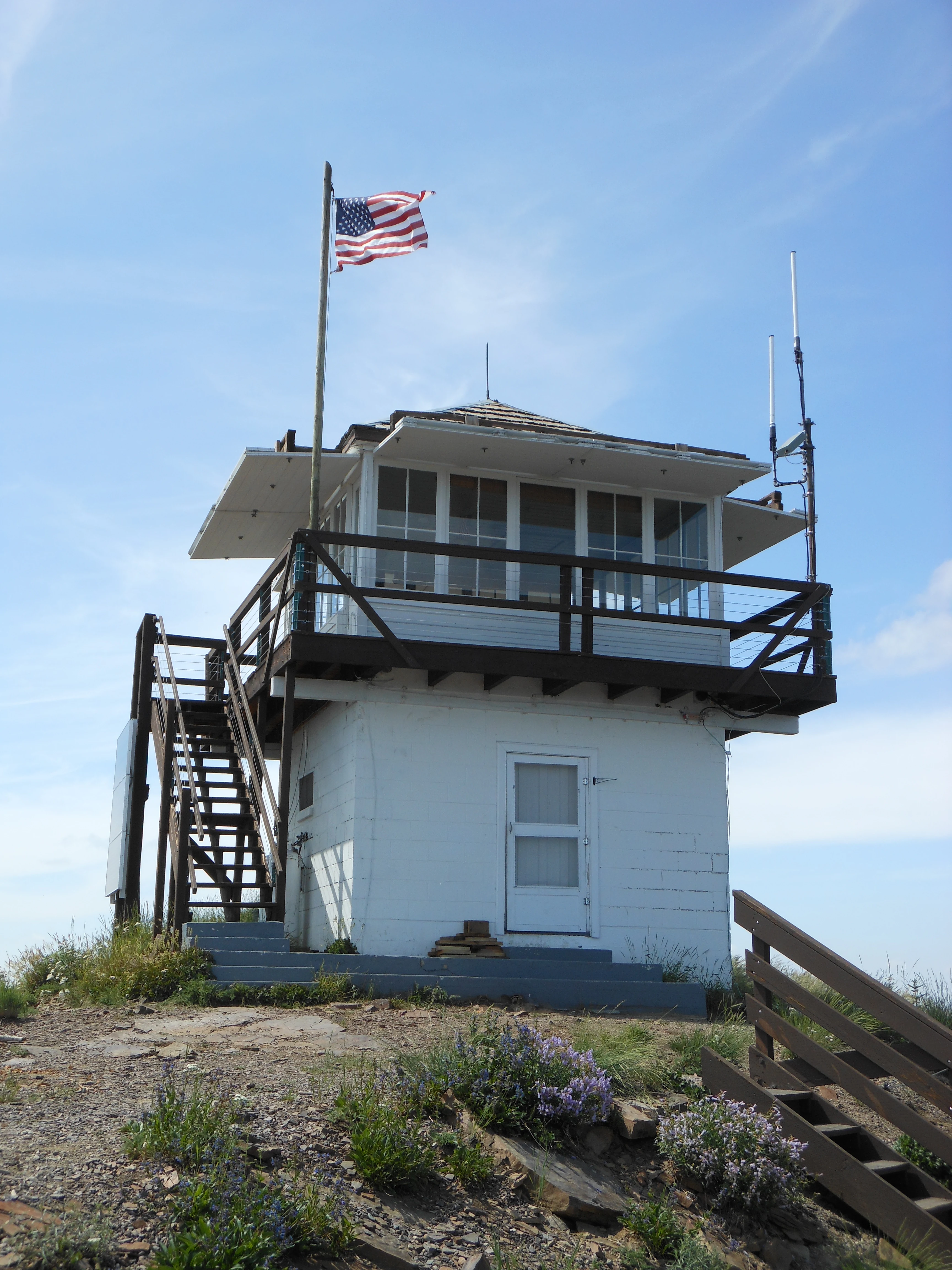
A small, white, square fire lookout tower with a wraparound wooden deck, stairs leading to the entrance, and a flying American flag, set atop a rocky mountain peak against a clear blue sky.
Little Guard Lookout situated on a mountain ridge in Idaho Panhandle National Forests.

Idaho Panhandle National Forests landscape and geographic character

The Idaho Panhandle National Forests sit within a rugged northern Rocky Mountain landscape where several parallel mountain ranges converge. The Selkirk, Cabinet, Purcell, Coeur d'Alene, and Bitterroot ranges form the dominant structural backbone, their ridges and basins interspersed with broad valleys and large bodies of water. Elevations rise from approximately 2,100 feet in the lowest valleys to about 7,600 feet along the highest peaks, producing strong ecological gradients over relatively short distances, while annual precipitation at higher elevations can reach up to 80 inches, sustaining deep snowpack and dense forest cover.

The hydrological imprint of the area is equally important. Major lakes, including Coeur d'Alene, Pend Oreille, and the upper and lower Priest Lakes, occupy large portions of the landscape, while major river valleys such as the St. Joe, Coeur d'Alene, Priest, Pend Oreille, Clark Fork, and Kootenai carve corridors through the forests. The interplay of mountains, lakes, and rivers produces a landscape of mixed closed-canopy forest, glacially shaped valleys, exposed ridgelines, and riparian zones that define much of the visual character of the panhandle.

This terrain also shapes the human experience of the forests. Wilderness-quality ridges, the Salmo-Priest Wilderness, roadless areas such as Selkirk Crest and the Scotchman Peaks, and historic routes like the Route of the Hiawatha all draw on the contrast between steep forested mountains and the lakes and river valleys that thread between them.
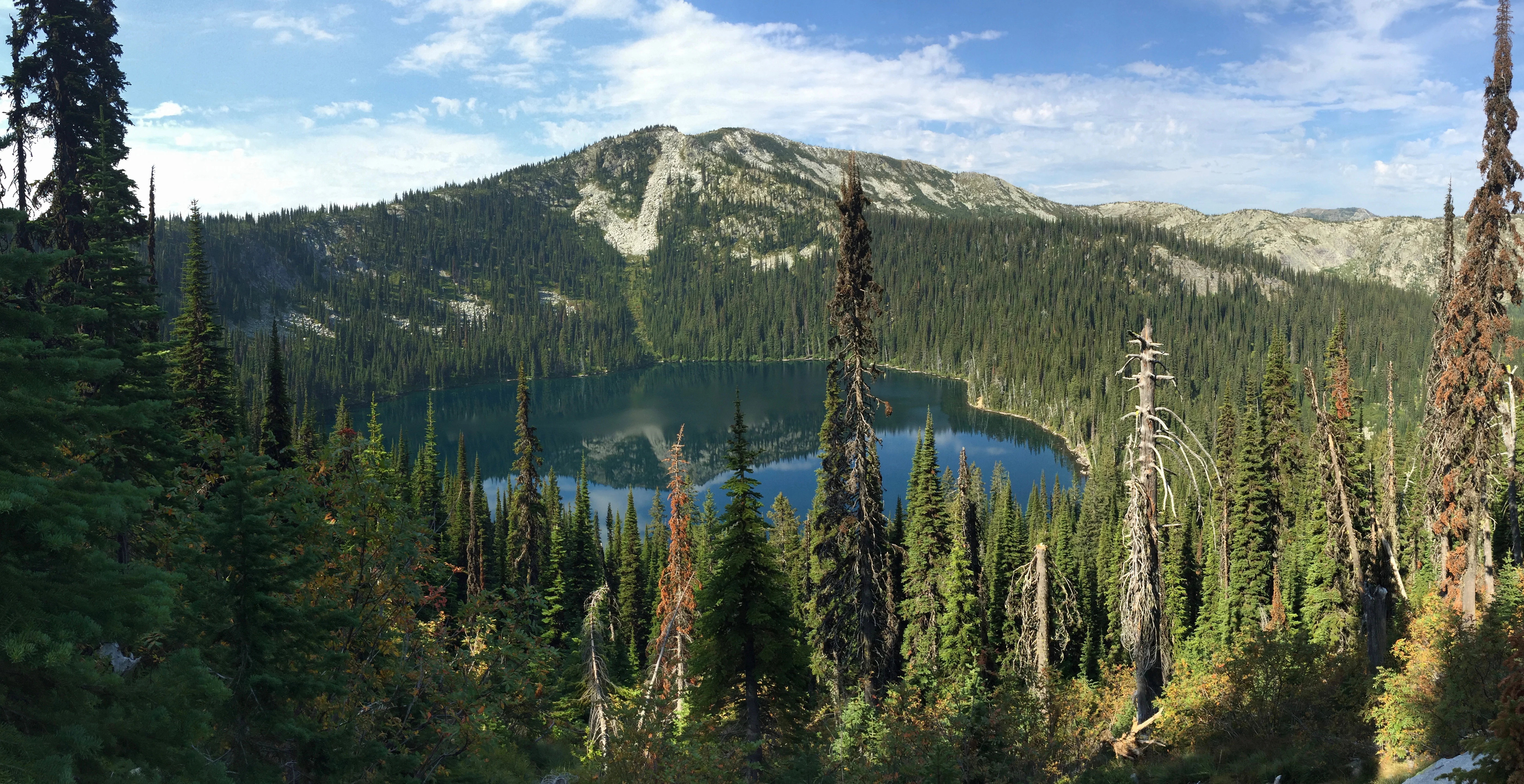
A panoramic mountain lake view surrounded by dense coniferous forest and a mountain peak in the distance.
Hidden Lake nestled within the Selkirk Mountains in Idaho Panhandle National Forests.

Idaho Panhandle National Forests ecosystems, habitats, and plant life

The Idaho Panhandle National Forests encompass a rich mosaic of northern Rocky Mountain ecosystems, ranging from low-elevation river valleys and lake margins to high-elevation subalpine ridges. Dense coniferous forests dominate much of the area, with stands of Douglas fir, western red cedar, hemlock, and other species typical of moist interior forests. The forests also include rare old-growth components, most visibly the ancient giant western red cedar found in the Settler's Grove and Roosevelt Grove.

Wetland, riparian, and aquatic habitats play an outsized ecological role. Lakes such as Coeur d'Alene, Pend Oreille, and the Priest Lakes, alongside rivers including the St. Joe, Coeur d'Alene, Priest, Pend Oreille, Clark Fork, and Kootenai, support diverse fish populations, aquatic mammals, and water-associated birds. These water bodies, combined with high precipitation and snowpack, sustain cold, well-oxygenated streams and complex shoreline habitats across the region.

At higher elevations, the vegetation transitions toward subalpine and alpine character, while lower slopes and valley bottoms support mixed forest, shrub communities, and meadow complexes. Throughout the elevational gradient, the interplay of forested slopes, water features, and exposed ridges creates a varied ecological template that supports a wide range of species across the entire public-land complex.
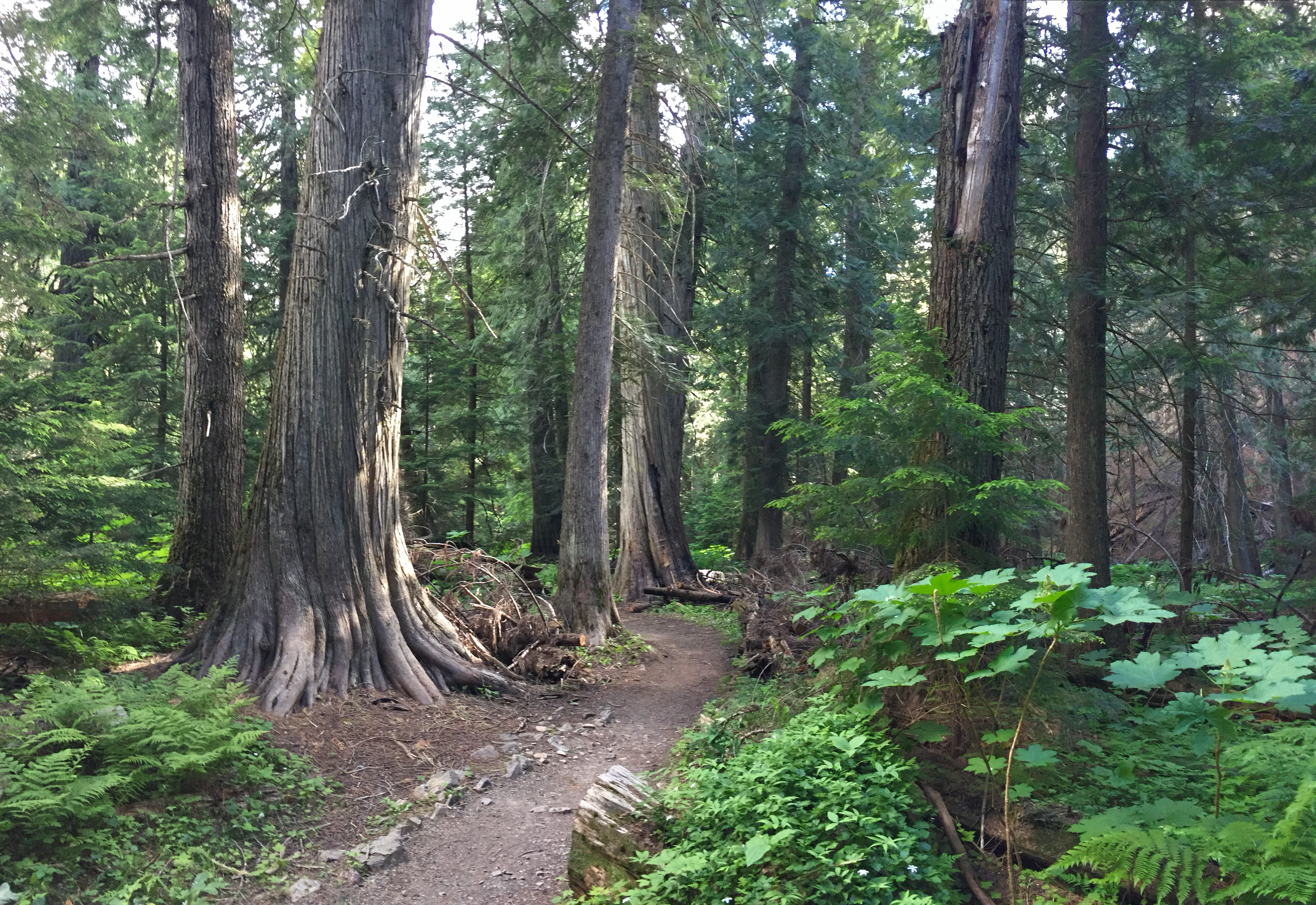
A dirt path meanders through a dense forest of mature Western red cedar trees with large, fluted trunks and lush green undergrowth including ferns.
A narrow dirt trail winds through the old growth cedar grove of Settlers Grove.

Idaho Panhandle National Forests wildlife and species highlights

The Idaho Panhandle National Forests support one of the most diverse mammal communities in the inland Pacific Northwest. Large ungulates such as elk, moose, white-tailed deer, and mule deer occupy much of the forested terrain, while carnivores include black bears, grizzly bears, wolves, cougars, coyotes, and bobcats. Smaller mammals, including raccoons, skunks, martens, minks, beavers, river otters, and wolverines, are also part of the fauna, the latter reflecting the wilderness character of much of the higher mountain habitat.

Birdlife across the forests is similarly varied. The area hosts bald eagles and golden eagles, osprey, ravens, blue jays, California quail, wild turkey, numerous species of grouse, and various owls. Raptors, neotropical migrants, and resident forest birds all use the mosaic of forest, lake, and river habitat, while the lakes and rivers of the panhandle provide important habitat for fish and for wildlife observation, with the network of waterways considered among the more notable freshwater fishing landscapes in the broader region.

Together, the combination of large predators, ungulates, riparian mammals, and a rich bird community gives the IPNF a wildlife profile that is strongly characteristic of the northern Rocky Mountain interior, with grizzly bears, wolverines, and wolves among the species that signal the relative wildness of the landscape.
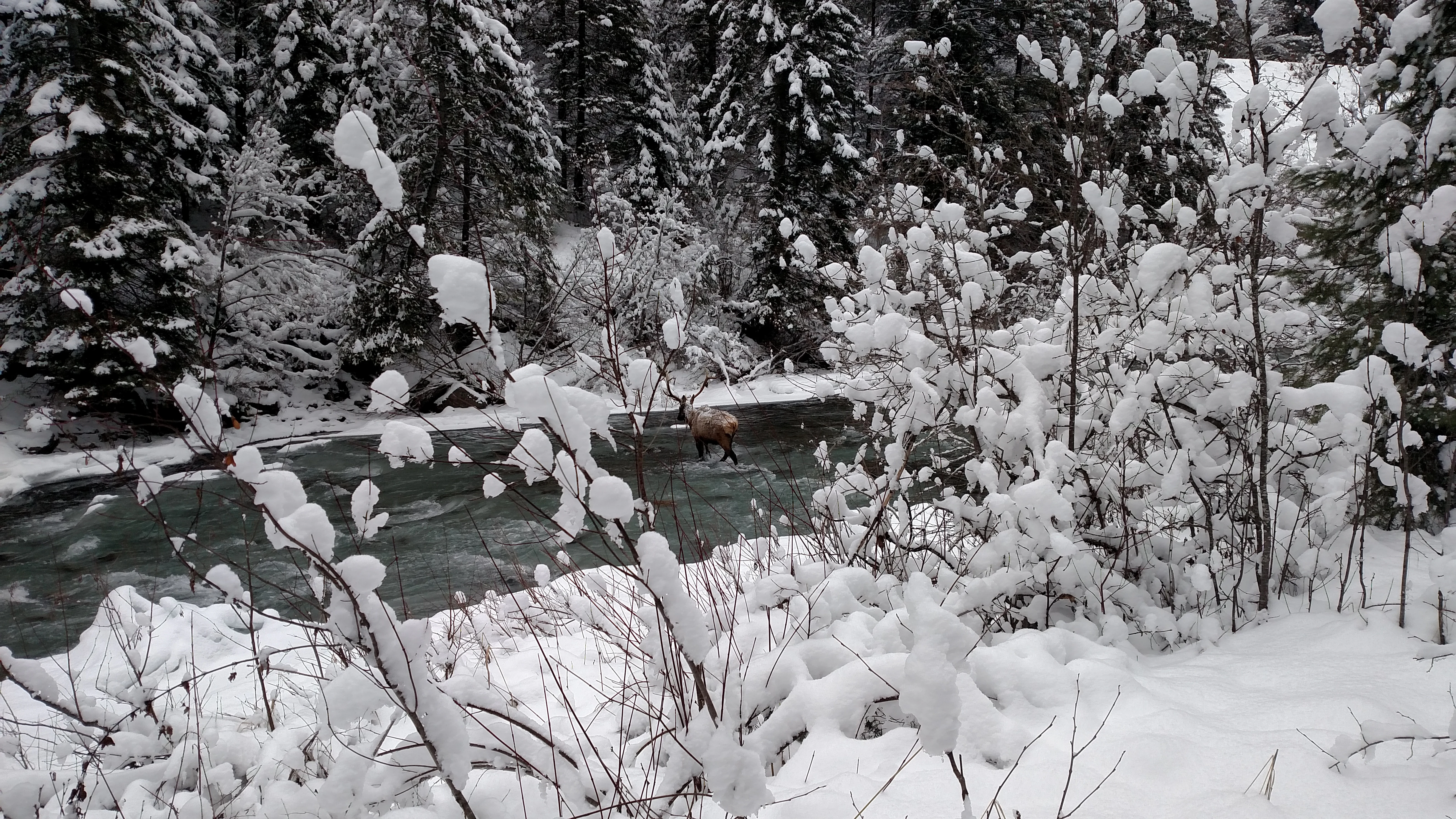
A small elk or deer stands near the bank of a dark river flowing through a forest covered in deep winter snow.
A winter scene along the North Fork of the Saint Joe River in the Idaho Panhandle National Forests.

Idaho Panhandle National Forests conservation status and protection priorities

The Idaho Panhandle National Forests play an important conservation role as one of the largest contiguous blocks of public forest land in the inland U.S. Northwest. Their size, ecological diversity, and connectivity to neighboring wilderness and roadless areas give them high value for the long-term persistence of wide-ranging species such as grizzly bears, wolves, wolverines, elk, and moose, many of which require extensive, relatively undisturbed habitat.

The forests also host formally protected components of the National Wilderness Preservation System, most notably the Salmo-Priest Wilderness, which straddles the IPNF and the neighboring Colville National Forest. Additional protected potential is represented by four proposed wilderness roadless areas: the Salmo-Priest Roadless Area (Idaho portion), Selkirk Crest, Scotchman Peaks, and Mallard-Larkins. Together, these areas highlight the landscape's value as a reservoir of intact northern Rocky Mountain habitat and as a hub of regional biodiversity conservation.

Beyond wilderness, the IPNF contributes to conservation through the protection of old-growth forest stands such as the Settler's Grove and Roosevelt Grove of Ancient Cedars, the management of large lake and river systems, and the preservation of sites such as the Emerald Creek Garnet Area, which protects a globally rare geological resource. The integrated management of what were previously separate national forests also reflects an effort to coordinate conservation across an ecologically connected landscape.

Top sights and standout views in Idaho Panhandle National Forests

The Idaho Panhandle National Forests stand out for their sheer scale and ecological richness, combining more than 2.5 million acres of forested mountains, lakes, and river valleys. Among their most distinctive features are the ancient cedar groves of Settler's Grove and Roosevelt Grove, which protect some of the oldest and largest western red cedar in the region.

Equally distinctive is the Route of the Hiawatha, a 15-mile rails-to-trails route incorporating the historic Taft Tunnel, which has become one of the signature recreational experiences in the inland Northwest. The Pulaski Tunnel Trail adds a deeper historical layer, linking visitors to the story of the firefighters of the Great Fire of 1910, while the Emerald Creek Garnet Area offers the rare chance to collect star garnets at one of only two known locations worldwide for this gem. Together, these features make the IPNF both an ecological stronghold and a landscape of strong cultural and recreational significance.
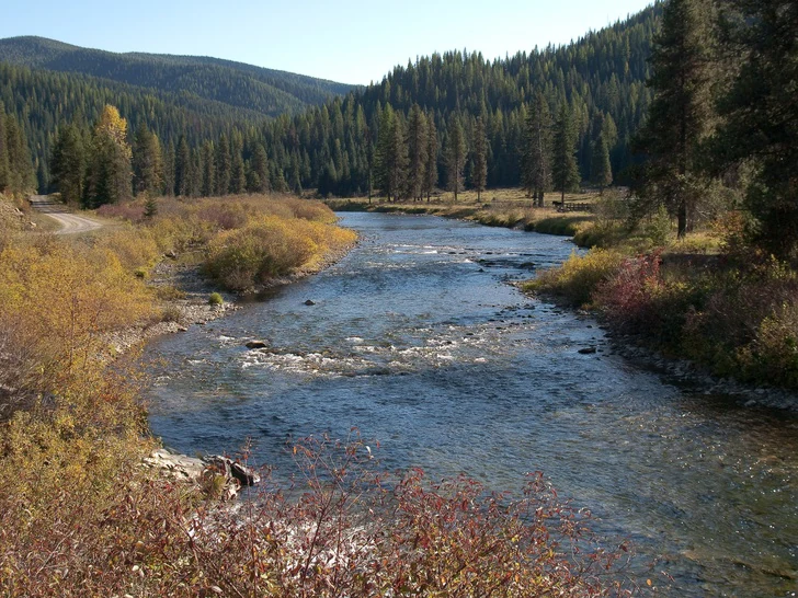
A wide, shallow river flows through a valley surrounded by dense coniferous forest under a clear sky; a dirt road is visible on the left bank.
The St. Joe River flows through a forested valley in the Idaho Panhandle National Forests.
Monthly climate preview

Long-term temperature ranges and monthly precipitation averages for representative terrain

Idaho Panhandle National Forests Climate Normals and Annual Weather Patterns

Historical monitoring at representative park coordinates records monthly average temperatures spanning from deep subzero winter minimums to warm summer maximums alongside varying precipitation amounts. Examining the complete twelve-month climatology profile reveals detailed long-term averages for annual temperature progression and precipitation distribution.
Annual mean6 °C
-5 °C19 °C
Jan-5°
Feb-4°
Mar
Apr
May10°
Jun13°
Jul18°
Aug19°
Sep14°
Oct
Nov-1°
Dec-5°
Warmest month
August

18.9 °C

Coolest month
December

-4.8 °C

Wettest month
November

4.3 mm/day

Driest month
July

0.8 mm/day

Park location guide

Geography guide, regional context, and park location map for Idaho Panhandle National Forests

Idaho Panhandle National Forests park geography, regions, and map view in United States of America

Understand where Idaho Panhandle National Forests sits in United States of America through a broader geographic reading of the surrounding landscape, nearby location context, and its mapped position within the national park landscape.

How Idaho Panhandle National Forests fits into United States of America

The United States of America is a federal presidential republic and one of the world's largest countries by area and population. It consists of 50 states across a vast territory spanning multiple time zones, with its capital in Washington, D.C. and largest city in New York City. The nation has a diverse economy, influential political system, and significant cultural and military presence globally.

Wider geography shaping Idaho Panhandle National Forests in United States of America

The United States occupies a vast territory in North America, bordered by Canada to the north and Mexico to the south. The 48 contiguous states stretch from the Atlantic to the Pacific Ocean, while Alaska occupies the northwestern region and Hawaii is an archipelago in the Pacific. The country encompasses diverse terrain including the Rocky Mountains, Appalachian Mountains, Great Plains, and extensive river systems.

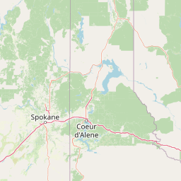
Map view of Idaho Panhandle National Forests

Use this park location map to pinpoint Idaho Panhandle National Forests in United States of America, understand its exact geographic position, and read its mapped placement within the surrounding landscape more clearly.

Pigeon | © OpenStreetMap contributors

Location context for Idaho Panhandle National Forests

Idaho

Visual reference of rugged mountain ranges, ancient cedar groves, and inland lakes

Idaho Panhandle National Forests Photos, Landscapes, and Mountain Scenery

Visual documentation captures the rugged mountain terrain, dense coniferous canopies, and aquatic corridors defining Idaho Panhandle National Forests. Protected area photography reveals the remote wild character and complex ecological gradients shaping this northern Rocky Mountain landscape.

A small, white, square fire lookout tower with a wraparound wooden deck, stairs leading to the entrance, and a flying American flag, set atop a rocky mountain peak against a clear blue sky.

A panoramic mountain lake view surrounded by dense coniferous forest and a mountain peak in the distance.

A dirt path meanders through a dense forest of mature Western red cedar trees with large, fluted trunks and lush green undergrowth including ferns.

A small elk or deer stands near the bank of a dark river flowing through a forest covered in deep winter snow.

A wide view of a snowy mountain slope covered in frost-dusted evergreen trees under a clear blue sky.

A wide, shallow river flows through a valley surrounded by dense coniferous forest under a clear sky; a dirt road is visible on the left bank.

Panoramic landscape view of a rocky, forested mountain ridge under a clear blue sky.

A small, tiered waterfall cascades over mossy rock faces into a creek, surrounded by ferns and fallen logs in a lush forest.

A mountainous landscape showing foreground evergreen trees framing a view of rolling forested hills and jagged peaks in the distance.

Park atlas

Compare connected northern Rocky Mountain landscapes and protected areas

Exploring Other Parks Near Idaho Panhandle National Forests

Browse nearby national forests and protected areas that share the rugged mountain terrain of Idaho Panhandle National Forests. Examining adjacent regional ecosystems provides deeper context for the vast coniferous forests and river valleys of the Pacific Northwest.
A soft watercolor painting depicting rolling mountains in the background with a line of forest in the midground and open terrain in the foreground.
Protected landscapeMontana
About 27 km away#1 closest

Northeast

Kootenai National Forest: Geography and Protected Land Map for Northwestern Montana

Northern Rockies mountain ranges and watershed analysis.

Spanning over two million acres, Kootenai National Forest represents a critical protected landscape in the Northern Rockies. This atlas entry details the interplay between the Cabinet Mountains, regional river systems like the Kootenai and Clark Fork, and the dense conifer forests that define this uniquely wet corner of Montana.

Area
8,900 km²
Established
1907
Relief
Mountain
Climate
Temperate
Protected areaMontana
About 39 km away#2 closest

Southeast

Lolo National Forest: An Atlas of Protected Lands and Mountainous Terrain in Montana

Ecological transition zone of the northern Rocky Mountains

This protected area covers two million acres of diverse northern Rocky Mountain geography. Known for its massive western red cedars and transitional ecology, the forest features a complex network of ridgelines, glacial lake basins, and river corridors that serve as vital habitat across the Montana landscape.

Area
8,894.85 km²
Established
1906
Relief
Mountain
Climate
Temperate
A soft watercolor illustration depicting a winding river flowing through a gentle landscape with distant rolling hills and scattered trees.
Protected areaWashington
About 155 km away#3 closest

West

Lake Roosevelt National Recreation Area: An Atlas of Washington Reservoir Landscapes

A sprawling protected region spanning the Columbia River corridor.

Lake Roosevelt National Recreation Area represents a massive, water-defined corridor in eastern Washington. The park preserves the 130-mile Franklin D. Roosevelt Lake, where steep basalt terrain meets arid shrub-steppe. This protected unit offers deep insight into the regional geography of the Columbia Plateau, featuring historical sites and river-system infrastructure that define the landscape's character.

Area
406.3 km²
Established
1946
Visitors
1.2M annual
Relief
Lowland
Wildlife reserveMontana
About 169 km away#4 closest

East

Mission Mountains Wilderness: A Rugged Protected Area in the Montana Rocky Mountains

Glacial topography and high elevation alpine ecosystems

Mission Mountains Wilderness is a defining landmark in northwestern Montana, characterized by a steep and narrow mountain spine that rises abruptly above the Flathead Valley. The area protects a full spectrum of ecosystems, from dense coniferous forests to exposed talus slopes and alpine tundra. With its glacially carved cirques and deep U shaped valleys, this wilderness functions as a key component of a larger, jointly managed regional conservation landscape in the United States.

Area
298.97 km²
Established
1975
IUCN
Ib
Relief
Mountain
National parkMontana
About 178 km away#5 closest

Northeast

Glacier National Park: A Montana National Park with Distinct Protected Landscape Geography

Explore its mapped boundaries and regional natural terrain.

Glacier National Park represents a significant national park entity within Montana, providing a unique lens for understanding protected landscapes and regional geography. As a key component of the US protected areas network, it offers valuable insights into mapped park boundaries and the surrounding natural terrain. This page serves as a gateway to exploring the specific geographic context and landscape identity of Glacier National Park.

Area
4,100.77 km²
Established
1910
IUCN
II
Visitors
2.9M annual
Wildlife reserveMontana
About 184 km away#6 closest

East

Rattlesnake Wilderness: Exploring the Protected Landscapes and Geography of Montana

Rugged alpine terrain and roadless mountain wilderness in the Northern Rockies.

Located in the Lolo National Forest of western Montana, Rattlesnake Wilderness protects an essential network of forested slopes, alpine ridges, and drainage headwaters. This roadless wildlife reserve provides an ecologically intact landscape that serves as a core component of the northern Rockies wilderness system, offering a clear view into the rugged relief of the Rattlesnake Mountains and their significant influence on local watersheds.

Area
133.45 km²
Established
1980
IUCN
Ib
Relief
Mountain
State or regional parkBritish Columbia
About 187 km away#7 closest

Northwest

King George VI Provincial Park: Protected Riparian Woodland in Southeastern British Columbia

Ecological atlas of old growth cottonwood habitats

King George VI Provincial Park functions as a significant conservation enclave in southeastern British Columbia, known for its dense stands of old growth black cottonwood. These mature trees create a unique closed canopy environment that serves as critical nesting ground for specialized bird species. This park represents a focused, passive protected area that preserves rare riparian forest structure against a backdrop of regional highway corridors and mixed use terrain.

Area
1.619 km²
Established
1937
IUCN
III
Relief
Lowland
A watercolor painting of a serene landscape with coniferous trees, rolling hills, and soft-toned, layered mountains.
Protected landscapeMontana
About 193 km away#8 closest

Southeast

Rattlesnake National Recreation Area: Geography and Protected Landscape Analysis

A mapped Northern Rockies gateway in western Montana

The recreation area encompasses 28,000 acres of forested mountain terrain, montane wetlands, and creek-carved valleys located just north of Missoula. This protected landscape is defined by its diverse trail network and significant ecological systems, including the rare Sphagnum bogs of Shoo Fly Meadows. The area provides essential habitat for grizzly bears, elk, and bull trout while framing a transition zone into the remote backcountry of the surrounding national forest.

Area
110 km²
Established
1980
Relief
Mountain
Scope
Terrestrial

Common questions about visiting, size, designation, and location context for Idaho Panhandle National Forests

Idaho Panhandle National Forests FAQs for park facts, access, geography, and protected area context

Find quick answers about Idaho Panhandle National Forests, including protected-area facts, park geography, trail and visitor context, and how the park fits into its surrounding country and regional landscape.
MoriAtlas Explorer

Continue Your Protected Areas Search Across the Global Atlas

Deepen your exploration by continuing the structured search for national parks and protected areas worldwide. Utilize the comprehensive filtering capabilities to compare different conservation landscapes and refine your understanding of global park geography. Discover more about the distribution and characteristics of protected natural areas.

Global natural geography