

Mori Atlas logo
Nature reserveÎles de la Paix Migratory Bird Sanctuary

A strategic riverine wetland sanctuary preserving low-lying islands and migratory waterfowl habitats

Îles de la Paix Migratory Bird Sanctuary: Mapping Protected Island Landscapes in Quebec

The Îles de la Paix Migratory Bird Sanctuary encompasses a unique network of low-lying islands and shallow riverine waters within the St. Lawrence River basin near Montreal. This federal nature reserve provides essential stopover habitats characterized by flooded forests and marshlands that shift with seasonal water levels. Explore the geographic boundaries and regional context of these protected river islands that serve as a productive refuge for migratory birds within a heavily developed metropolitan setting.

migratory bird sanctuarywaterfowlst lawrence riverriver islandsmarshlandflooded forest
A flat-style digital illustration of a wetland landscape featuring green islands in a calm body of water, with cattails in the foreground and a large bluff in the background under a sunrise sky.

Îles de la Paix Migratory Bird Sanctuary

Nature reserve

Park overview

Structured park overview, official facts, and landscape profile for Îles de la Paix Migratory Bird Sanctuary

Îles de la Paix Migratory Bird Sanctuary park facts, protected area profile, and essential visitor context

Review the core facts for Îles de la Paix Migratory Bird Sanctuary, including designation, size, terrain, visitor scale, habitats, and operating context in one park-focused overview.

About Îles de la Paix Migratory Bird Sanctuary

The Îles de la Paix Migratory Bird Sanctuary is a small but ecologically rich federal protected area in the St. Lawrence River system of southwestern Quebec. Although it lies within the greater Montreal urban region, just south of the Island of Montreal and near the town of Beauharnois, it preserves a landscape that is fundamentally shaped by the river itself: a cluster of low islands together with surrounding shallow water, periodically flooded forests, and marshy margins.

The sanctuary was formally established in 1972 and is administered by the Canadian Wildlife Service. Its designation as a Migratory Bird Sanctuary places it within Canada's network of sites that protect habitats critical to the conservation of migratory birds protected under federal wildlife law. The same area is also recognized as the Îles de la Paix National Wildlife Area and overlaps with an Important Bird Area identified by BirdLife International, reinforcing its role in continental bird conservation.

Ecologically, the site functions as a key node in the St. Lawrence migratory flyway. Each spring, large numbers of ducks arrive to rest and feed in the open water and flooded habitats, and in autumn the islands and surrounding waters host an even larger migratory congregation of tens of thousands of birds before they continue south. In summer, the same islands support active breeding colonies of waterfowl, herons, terns, grebes, marsh-nesting songbirds, and ground-nesting species such as owls. The combination of these seasonal roles makes the sanctuary a year-round contributor to bird conservation in a heavily developed region.

Although small in absolute size, Îles de la Paix exemplifies how river-island and marsh systems can have outsized conservation value. By protecting a place where forest, wetland, and open water meet at the edge of one of North America's great rivers, the sanctuary safeguards habitat that is increasingly rare elsewhere in the densely settled St. Lawrence Lowlands.

Quick facts and research context for Îles de la Paix Migratory Bird Sanctuary

The Îles de la Paix Migratory Bird Sanctuary is located in southwestern Quebec in the expanded section of the St. Lawrence River known as Lac Saint-Louis, south of the Island of Montreal. It was established in 1972 by the Canadian Wildlife Service.

The sanctuary covers approximately 10.9 square kilometres and centers on a group of low islands together with 500 metres of surrounding water. It overlaps with the related Îles de la Paix National Wildlife Area and is included within a BirdLife International Important Bird Area, reflecting its significance for both migratory and breeding waterbirds.

Protection and recognition

Documented terrestrial protection scope and baseline conservation metrics

Îles de la Paix Migratory Bird Sanctuary Protection Status and Recognition

Terrestrial protection status records provide a structured baseline for understanding the management framework of Îles de la Paix Migratory Bird Sanctuary. Official data entries organize baseline conservation metrics and institutional recognition sources for comprehensive protected-area analysis.

Protection details

Protection scope
Terrestrial
Transboundary protection
No
WDPA ID
555704281
Park context

Deeper park guide and search-rich context for Îles de la Paix Migratory Bird Sanctuary

Îles de la Paix Migratory Bird Sanctuary history, landscape, wildlife, and travel context

Explore Îles de la Paix Migratory Bird Sanctuary through its history, landscape character, ecosystems, wildlife, conservation priorities, cultural context, and seasonal travel timing in a structured park guide built for atlas discovery and search intent.

Why Îles de la Paix Migratory Bird Sanctuary stands out

The sanctuary is best known as a major St. Lawrence River stopover for migratory waterfowl, particularly diving ducks such as scaup and goldeneye as well as common mergansers, and as a breeding ground for a diverse community of marsh and island-nesting birds. The combination of partly flooded forest, marsh, and open water on islands that barely rise above river level makes the site exceptionally productive for waterbirds in both spring and autumn. It is also notable for being one of the federal Migratory Bird Sanctuary designations located within the heavily urbanized Montreal region, where it preserves a meaningful pocket of natural river-island habitat very close to major population centres.
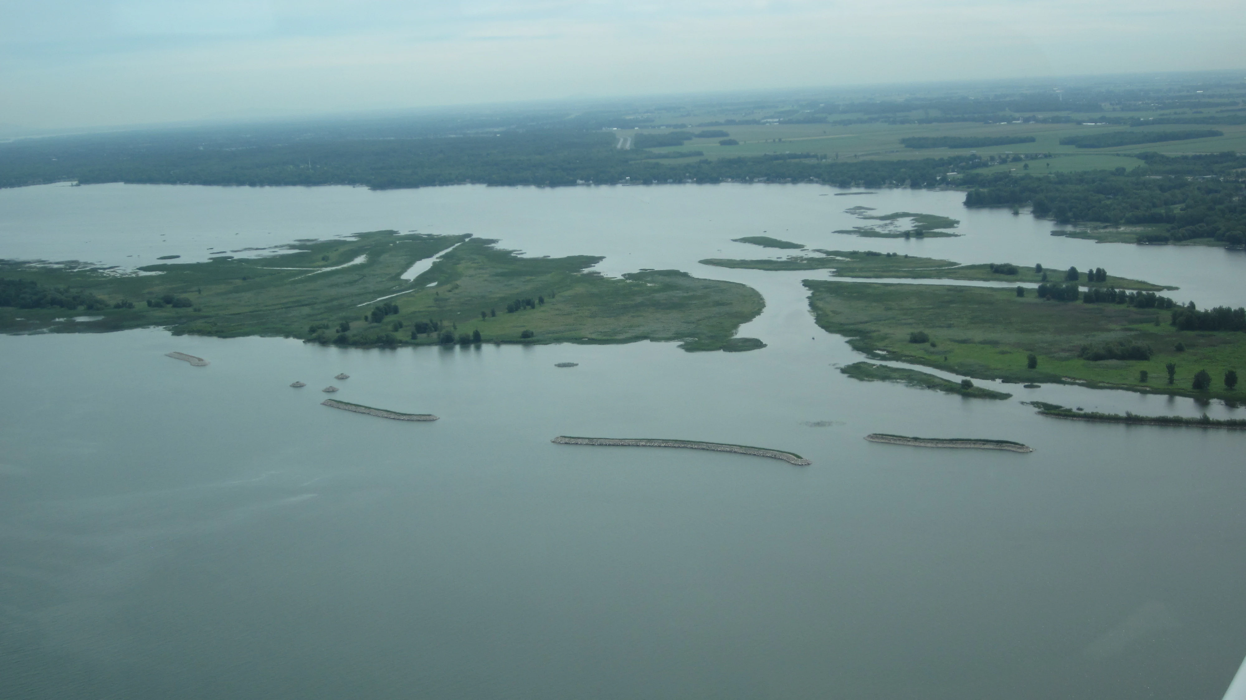
An aerial view showing green islands and marshy areas surrounded by the waters of the Saint Lawrence River.
An aerial view of the Îles de la Paix Migratory Bird Sanctuary in Quebec.

Îles de la Paix Migratory Bird Sanctuary history and protected-area timeline

The Îles de la Paix Migratory Bird Sanctuary was established in 1972 as part of Canada's federal Migratory Bird Sanctuary program, administered by the Canadian Wildlife Service. The designation was intended to secure the island group and its surrounding waters as protected habitat for migratory birds using the St. Lawrence River corridor.

Over time, the area's conservation profile expanded beyond the original sanctuary designation. It later became associated with the Îles de la Paix National Wildlife Area, strengthening its long-term protection through a complementary federal framework. BirdLife International has additionally included the broader area within an Important Bird Area, recognizing its importance at an international scale for migratory and breeding bird populations.

Îles de la Paix Migratory Bird Sanctuary landscape and geographic character

The landscape of the sanctuary is shaped almost entirely by the hydrology of the St. Lawrence River. The protected area lies in the natural widening of the river known as Lac Saint-Louis, just upstream of Montreal, where the St. Lawrence spreads out into a broad lake-like expanse. Within this setting, the sanctuary centres on the small islands of the Îles de la Paix group, surrounded by a buffer of open water extending roughly 500 metres from the islands.

The islands themselves sit only a few metres above the waterline, which gives the landscape a distinctly low and vulnerable profile. During high-water periods, parts of the islands are routinely inundated, and the boundary between land and water shifts with the seasonal flow of the great river. This dynamic produces a landscape mosaic of partly flooded forest, marsh, and shallow open water rather than clearly defined dry land.

The proximity of the small town of Beauharnois on the southern shore and the broader Montreal metropolitan area to the north emphasizes how unusual this near-natural river-island environment is within its regional context. The scenery is essentially a working river landscape, dominated by water, low wooded hummocks, marsh vegetation, and the open sky of the St. Lawrence valley.

Îles de la Paix Migratory Bird Sanctuary ecosystems, habitats, and plant life

Ecologically, the sanctuary reflects the character of the St. Lawrence Lowlands where the great river expands into Lac Saint-Louis. Despite its small absolute size, the area concentrates several important habitat types within a single protected boundary: open river water, shallow shoreline water, marsh, and forest patches on low islands that are repeatedly shaped by flooding.

This habitat mosaic supports rich seasonal biological activity. In spring and autumn the open water and flooded margins become staging and feeding areas for migratory waterfowl, while in summer the drier portions of the islands provide nesting substrates for ground-nesting and tree-nesting birds, as well as habitat for marsh-associated songbirds. The repeated natural flooding regime also creates conditions that continually reset and rejuvenate these habitats, favouring a dynamic mosaic rather than a stable fixed community.

Îles de la Paix Migratory Bird Sanctuary wildlife and species highlights

Migratory and breeding waterbirds are the central feature of the sanctuary's wildlife. In spring the area is regularly visited by large numbers of ducks, and during the autumn migration the islands and surrounding waters host an estimated thirty thousand or more birds. Diving ducks such as lesser scaup, common goldeneye, and common mergansers are particularly characteristic of the autumn staging flocks that use these productive, open-water feeding grounds.

In the breeding season the sanctuary supports a wide variety of waterfowl and marsh-associated species. Ducks nesting here include ring-necked duck, mallard, northern pintail, gadwall, wood duck, green-winged teal, and blue-winged teal. Colonial and marsh-nesting waterbirds also make use of the islands, including black tern, common tern, pied-billed grebe, green heron, and black-crowned night-heron, together with American coot, spotted sandpiper, great horned owl, and marsh wren. This rich breeding community reflects the site's combination of nesting cover, open water, and protected isolation from much human disturbance during the nesting period.

The combination of large seasonal concentrations of migratory ducks and a diverse array of breeding species gives the sanctuary unusual wildlife significance for such a small area embedded in a major metropolitan region.

Îles de la Paix Migratory Bird Sanctuary conservation status and protection priorities

The conservation significance of Îles de la Paix rests on its layered protection status. As a Migratory Bird Sanctuary established under Canadian federal wildlife legislation, it provides legal protection for migratory birds and their habitats throughout the year. The overlap with the Îles de la Paix National Wildlife Area adds an additional federal mechanism aimed at broader wildlife and habitat protection, while recognition as part of a BirdLife International Important Bird Area places the site within an international bird-conservation framework.

From a habitat perspective, the sanctuary protects islands, marshes, and shallow St. Lawrence waters that are scarce elsewhere in the corridor between Montreal and the river's mouth. Flooded forest, marsh, and open-water edge habitats of this quality have been heavily reduced along the St. Lawrence, and the sanctuary therefore preserves a disproportionately valuable example of these habitat types.

The site's role as both a major autumn staging area for migratory ducks and an active breeding area for waterfowl and marsh-nesting birds also gives it strong functional conservation value, supporting bird populations that range far beyond the immediate Montreal region across the broader Atlantic and Mississippi flyways.

Top sights and standout views in Îles de la Paix Migratory Bird Sanctuary

A federal Migratory Bird Sanctuary on low St. Lawrence River islands south of Montreal, with overlapping National Wildlife Area and Important Bird Area designations.

Notable for supporting up to around thirty thousand migratory waterfowl in autumn and a strikingly diverse breeding bird community on islands barely above the waterline.

An unusually natural island-and-marsh refuge preserved within the heavily developed Montreal metropolitan region, where flooded forests, marsh, and open river water meet at the edge of one of North America's great rivers.

Best time to visit Îles de la Paix Migratory Bird Sanctuary

The sanctuary's character shifts sharply with the seasons in ways typical of St. Lawrence River sites. Spring brings the arrival of large numbers of ducks using the open water and flooded edges as staging habitat, making it an active time for waterbird observations. Autumn is the peak period of bird abundance, as tens of thousands of migratory waterfowl, including diving ducks and mergansers, concentrate on the islands and surrounding waters before continuing south.

Summer is the breeding season, when the islands host nesting waterfowl, herons, terns, grebes, and marsh-nesting songbirds, and the flooded-forest and marsh habitats are at their most biologically active. Winter conditions, by contrast, leave the low islands exposed to ice, flooding, and snow cover and generally offer limited wildlife viewing, though freeze-up and break-up periods can still concentrate waterbirds elsewhere along Lac Saint-Louis.

Monthly climate preview

Long-term temperature ranges and monthly precipitation patterns measured at a representative coordinate

Îles de la Paix Migratory Bird Sanctuary Climate Normals and Annual Weather Rhythm

Representative coordinate records show substantial annual temperature variation alongside steady monthly precipitation levels across the sanctuary terrain. Detailed climate normals provide a complete month-by-month breakdown of average minimum and maximum temperatures.
Annual mean6 °C
-12 °C22 °C
Jan-12°
Feb-10°
Mar-3°
Apr
May13°
Jun19°
Jul22°
Aug21°
Sep16°
Oct
Nov
Dec-7°
Warmest month
July

21.5 °C

Coolest month
January

-11.7 °C

Wettest month
June

3.4 mm/day

Driest month
February

2.2 mm/day

Park location guide

Geography guide, regional context, and park location map for Îles de la Paix Migratory Bird Sanctuary

Îles de la Paix Migratory Bird Sanctuary park geography, regions, and map view in Canada

Understand where Îles de la Paix Migratory Bird Sanctuary sits in Canada through a broader geographic reading of the surrounding landscape, nearby location context, and its mapped position within the national park landscape.

How Îles de la Paix Migratory Bird Sanctuary fits into Canada

Canada is a federal parliamentary constitutional monarchy spanning North America from the Atlantic to the Pacific and Arctic Oceans. With a population of over 41 million, it is officially bilingual in English and French at the federal level. The country gained independence from the United Kingdom through a gradual process culminating in 1982.

Wider geography shaping Îles de la Paix Migratory Bird Sanctuary in Canada

Canada occupies the northern portion of North America, sharing its longest international border with the United States. The country extends from the Atlantic Ocean to the Pacific Ocean and northward into the Arctic Ocean, giving it the longest coastline of any nation.

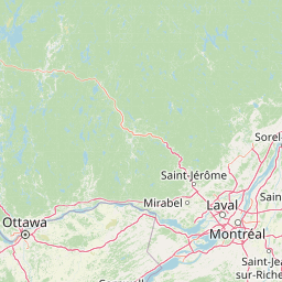
Map view of Îles de la Paix Migratory Bird Sanctuary

Use this park location map to pinpoint Îles de la Paix Migratory Bird Sanctuary in Canada, understand its exact geographic position, and read its mapped placement within the surrounding landscape more clearly.

Pigeon | © OpenStreetMap contributors

Location context for Îles de la Paix Migratory Bird Sanctuary

Quebec
Recorded earthquake history

View Recorded Seismic History for Îles de la Paix Migratory Bird Sanctuary

Investigate the historical record of seismic events documented near the Îles de la Paix Migratory Bird Sanctuary. MoriAtlas provides this organized catalogue to support geographic exploration of the St. Lawrence River region, offering clear insights into recorded earth movements associated with this specific protected landscape.

Îles de la Paix Migratory Bird Sanctuary Earthquake History

Catalogued events

18 events

Strongest magnitude

Magnitude 4.4

Most recent event

Feb 1, 2024

This history includes earthquakes recorded inside the park or within 50 km of its borders

Visual exploration of St. Lawrence River islands, flooded forests, and marshland habitats

Îles de la Paix Migratory Bird Sanctuary Photos and Landscape Scenery

Visual documentation captures the low-lying river islands and dynamic wetland habitats that define Îles de la Paix Migratory Bird Sanctuary. Photographic records reveal the protected terrain and open water scenery supporting migratory waterfowl along the St. Lawrence River.

An aerial view showing green islands and marshy areas surrounded by the waters of the Saint Lawrence River.

Park atlas

Compare adjacent protected areas, river islands, and wetland habitats across the regional flyway.

Parks Near Îles de la Paix Migratory Bird Sanctuary and Surrounding St. Lawrence Valley Reserves

Browse nearby national parks and protected areas sharing the distinctive wetland and river-island ecology of the St. Lawrence River corridor. Expanding the geographic comparison reveals broader regional conservation patterns and connected natural landscapes.
A soft, watercolor painting of a calm river winding through a green landscape with trees and rolling hills in the background.
Wildlife reserveQuebec
Mapped location lies within the park boundary#1 closest

West

Réserve nationale de faune des îles de la Paix: Geography of an Island Wetland Refuge

A protected wildlife corridor in southwestern Quebec

The Réserve nationale de faune des îles de la Paix comprises a cluster of islands and protected wetlands in the St. Lawrence River. This site provides critical nesting and staging grounds within a managed habitat system, connecting forested terrestrial areas with expansive aquatic zones essential for migratory bird species.

Area
1.87 km²
Established
1977
IUCN
Ia
Relief
Lowland
A soft watercolor painting depicting a wide, marshy wetland scene with gentle green hills in the distance and reflections on the water surface.
Wildlife reserveQuebec
About 59 km away#2 closest

Southwest

Réserve nationale de faune du lac-Saint-François: A Protected Wetland Landscape in Quebec

Explore wildlife reserve boundaries, riparian habitats, and St. Lawrence River geography.

This protected area safeguards a diverse freshwater wetland complex along the St. Lawrence River. Covering marshes, cedar stands, and mixed hardwood forests, the reserve provides a critical sanctuary for migratory species. The geography of the site offers a unique look at transition zones between open water and inland plains, serving as a key node for bird conservation in Quebec.

Area
15.21 km²
Established
1978
IUCN
III
Relief
Lowland
Wildlife reserveQuebec
About 69 km away#3 closest

Northeast

Réserve nationale de faune des îles de Contrecœur: Mapped Wildlife Reserve and Wetland Habitat

Protected freshwater ecosystems in the St. Lawrence River, Quebec

Discover the geographic footprint of the Réserve nationale de faune des îles de Contrecœur, a protected network of islands and channels in the St. Lawrence River. This entry provides context on the reserve's role in conserving emergent aquatic vegetation and waterfowl nesting sites within the broader southern Quebec landscape.

Area
3.12 km²
Established
1981
IUCN
Ia
Relief
Lowland
Watercolor painting of a lush green landscape featuring rolling hills in the distance, a meandering stream in the midground, and wetlands with cattails in the foreground.
Protected landscapeVermont
146 km away#4 closest

South

Green Mountain National Forest: Mapped Geography and Protected Landscape Analysis

Examining the wilderness backbone of Vermont's mountainous terrain

Gain insight into the expansive boundaries of Green Mountain National Forest, an essential protected area spanning the Green Mountains of Vermont. This profile details the forest's composition, ranging from high-elevation spruce-fir zones to mixed hardwood slopes and extensive federal wilderness corridors, providing a foundational geographic understanding of this vital northeastern landscape.

Area
1,615.31 km²
Established
1932
Relief
Mountain
Climate
Temperate
National parkQuebec
154 km away#5 closest

Northeast

La Mauricie National Park: Quebec National Park Atlas and Protected Landscape

Explore its mapped boundaries and natural terrain.

Delve into the protected landscape of La Mauricie National Park, a key national park situated within Quebec's diverse geography. This destination provides detailed insights into the park's mapped boundaries and its unique natural terrain, offering a structured approach to understanding protected areas and regional landscapes. It serves as an essential point for exploring the park's geographic identity and its place within the Canadian conservation atlas.

Area
536 km²
Established
1970
IUCN
II
Visitors
278.9K annual
Wildlife reserveOntario
About 164 km away#6 closest

West

Rideau Migratory Bird Sanctuary: Protected Wildlife Reserve and Regional Waterfowl Habitat

Riparian conservation zones along the Rideau River in Ontario

The Rideau Migratory Bird Sanctuary protects a strategically important riparian corridor within Ontario. This federal wildlife reserve provides essential refuge for migratory birds along the Rideau River system, offering a specialized look at the region's diverse wetland margins and floodplain geography.

Area
7.52 km²
Established
1957
Watercolor painting of green hills, islands, and a body of water under a pale yellow sky
National parkOntario
168 km away#7 closest

Southwest

Thousand Islands National Park: Exploring Ontario's Protected Landscape Geography

Discover the mapped terrain and regional context of this national park.

Uncover the protected landscape identity of Thousand Islands National Park, a key national park located in Ontario. This resource focuses on its geographic setting, mapped boundaries, and overall atlas context, providing a clear understanding of its role as a protected area. Explore how its unique terrain contributes to the regional geography and the broader national park network, offering valuable insight for landscape-focused discovery.

Area
24.4 km²
Established
1904
IUCN
II
Visitors
109.3K annual
Protected areaAddison County
About 173 km away#8 closest

Southeast

Joseph Battell Wilderness: Mapping Protected Ridges in the Green Mountain National Forest

A high-elevation Appalachian landscape in Addison County, Vermont.

Spanning over twelve thousand acres, the Joseph Battell Wilderness preserves a critical core of the Green Mountains. This protected area features dramatic cliff faces like Mount Horrid and a continuous sequence of summits exceeding three thousand feet. The region provides a deep look at northern hardwood habitats and the geographic influence of the Long Trail within the broader Vermont mountain landscape.

Area
49.92 km²
Established
2006
Relief
Mountain
Climate
Temperate

Common questions about visiting, size, designation, and location context for Îles de la Paix Migratory Bird Sanctuary

Îles de la Paix Migratory Bird Sanctuary FAQs for park facts, access, geography, and protected area context

Find quick answers about Îles de la Paix Migratory Bird Sanctuary, including protected-area facts, park geography, trail and visitor context, and how the park fits into its surrounding country and regional landscape.
MoriAtlas Explorer

Continue Your Protected Areas Search Across the Global Atlas

Deepen your exploration by continuing the structured search for national parks and protected areas worldwide. Utilize the comprehensive filtering capabilities to compare different conservation landscapes and refine your understanding of global park geography. Discover more about the distribution and characteristics of protected natural areas.

Global natural geography