
Mori Atlas logo
Nature reserveNaturschutzgebiet Isla Glischa-Arvins-Seglias

Discover the dynamic alpine river geography and revitalized riparian habitats of this Swiss nature reserve

Naturschutzgebiet Isla Glischa-Arvins-Seglias: A Protected Floodplain Landscape in Graubünden

Naturschutzgebiet Isla Glischa-Arvins-Seglias comprises an expansive floodplain corridor along the Inn River in the Upper Engadin. This protected area within Graubünden preserves a complex mosaic of gravel islands, marshes, peatlands, and riparian forests that reflect ongoing alpine river restoration efforts. The reserve encompasses vital wetlands and riverine dynamics that provide critical habitat while demonstrating the interplay between natural alluvial systems and traditional landscape management.

floodplainInn RiverEngadinGraubündenriverine habitatriparian forest
A flat vector-style illustration showing a wide river winding through a valley surrounded by steep, purple and yellow mountains and a forest of pine and deciduous trees under a soft sun.

Naturschutzgebiet Isla Glischa-Arvins-Seglias

Nature reserve

Park overview

Structured park overview, official facts, and landscape profile for Isla Glischa-Arvins-Seglias Nature Reserve

Isla Glischa-Arvins-Seglias Nature Reserve park facts, protected area profile, and essential visitor context

Review the core facts for Isla Glischa-Arvins-Seglias Nature Reserve, including designation, size, terrain, visitor scale, habitats, and operating context in one park-focused overview.

About Isla Glischa-Arvins-Seglias Nature Reserve

Isla Glischa-Arvins-Seglias is a nationally recognized floodplain reserve along the Inn River in the Upper Engadin, in the canton of Graubünden, Switzerland. Covering roughly 87 hectares across the municipalities of Bever, La Punt-Chamues-ch, and Samedan, the reserve safeguards one of the most significant inland floodplain systems in the Swiss Alps.

The protected area extends along several kilometers of the Inn, from the new mouth of the Flaz near Samedan to where the Ova Chamuera joins the Inn near La Punt-Chamues-ch. The flat valley floor and the low gradient of the Inn, which drops only about 15 meters through this stretch, historically supported a wide, partially marshy floodplain. Although centuries of human intervention altered much of this natural hydrology, the reserve still preserves meaningful remnants of that original riverine landscape, including riparian forests, gravel banks, side channels, small ponds, and wet meadows.

The name of the reserve reflects the Romansh-speaking cultural heritage of the Engadin. It refers to three geographic reference points at the upper and lower ends of the floodplain: Isla Glischa, an area of small ponds and waters south of the reserve, and the place names Arvins and Seglias at the northern end. The Romansh word 'isla' means 'island', while 'glischa' means 'flat' or 'slippery', illustrating how local linguistic tradition captures the physical character of these riverine landscapes.

A defining aspect of Isla Glischa-Arvins-Seglias is its ecological restoration story. Through the 19th and 20th centuries, the Engadin communities built extensive dams and channels along the Inn and its tributaries to control flooding and reclaim farmland. After severe flood damage in the mid-20th century, the river near Bever was reduced to a narrow, straightened canal. Beginning in 2013, a multi-stage revitalization program started returning space to the river, opening retention areas, restoring side channels, and relocating key roads and infrastructure, including a multi-kilometer stretch of the cantonal road near La Punt. This restoration effort is creating new habitats for fish, waterbirds, amphibians, and riparian vegetation while also improving flood safety.

The reserve is part of the Federal Inventory of Floodplains of National Importance and contributes to broader biodiversity protection in the region. It supports nationally important amphibian breeding sites near Bever and significant peatland habitats along the Inn. Combined with its proximity to historic Engadin villages, the Engadin Skimarathon route, and the surrounding alpine environment, Isla Glischa-Arvins-Seglias offers a distinctive blend of natural, cultural, and ecological significance.

Quick facts and research context for Isla Glischa-Arvins-Seglias Nature Reserve

Isla Glischa-Arvins-Seglias lies along the Inn River in the Upper Engadin, within the Swiss canton of Graubünden. It was designated as a nationally important floodplain in 1992 and is governed by the Federal Ordinance on the Protection of Floodplains of National Importance. The reserve covers approximately 87 hectares and spans the municipalities of Bever, La Punt-Chamues-ch, and Samedan at roughly 1,685 meters above sea level.

The protected landscape is shaped by the Inn and several tributaries, including the Flaz, Ova Chamuera, and Beverin. It features gravel lakes such as Lej da Gravatscha, riparian wetlands, and historically marshy valley floor. A long-term restoration project launched in 2013 has been actively revitalizing the previously channelized river section, reconnecting floodplains and improving habitat quality.

Protection and recognition

Documented terrestrial protection scope, management records, and official conservation framing

Naturschutzgebiet Isla Glischa Arvins Seglias Protection Status and Designated Area Record

Naturschutzgebiet Isla Glischa Arvins Seglias holds a documented terrestrial protection status within global conservation databases. Verified administrative records outline the formal designation framework and territorial scope without relying on external recognition sources.

Protection details

Protection scope
Terrestrial
Transboundary protection
No
WDPA ID
148689
Park context

Deeper park guide and search-rich context for Isla Glischa-Arvins-Seglias Nature Reserve

Isla Glischa-Arvins-Seglias Nature Reserve history, landscape, wildlife, and travel context

Explore Isla Glischa-Arvins-Seglias Nature Reserve through its history, landscape character, ecosystems, wildlife, conservation priorities, cultural context, and seasonal travel timing in a structured park guide built for atlas discovery and search intent.

Why Isla Glischa-Arvins-Seglias Nature Reserve stands out

Isla Glischa-Arvins-Seglias is best known as one of the largest and most ecologically significant floodplain reserves in the Engadin. It preserves a rare example of a large, dynamic alpine river floodplain that once characterized the Inn valley before extensive flood-control engineering. The reserve is also known for its ongoing revitalization program, which is transforming a once heavily channelized river section back into a near-natural floodplain. Features such as the gravel lake Lej da Gravatscha, the marshes of Palüds-Agnas, and the expansive alluvial zone near Arvins make this a flagship project in Swiss inland floodplain conservation.
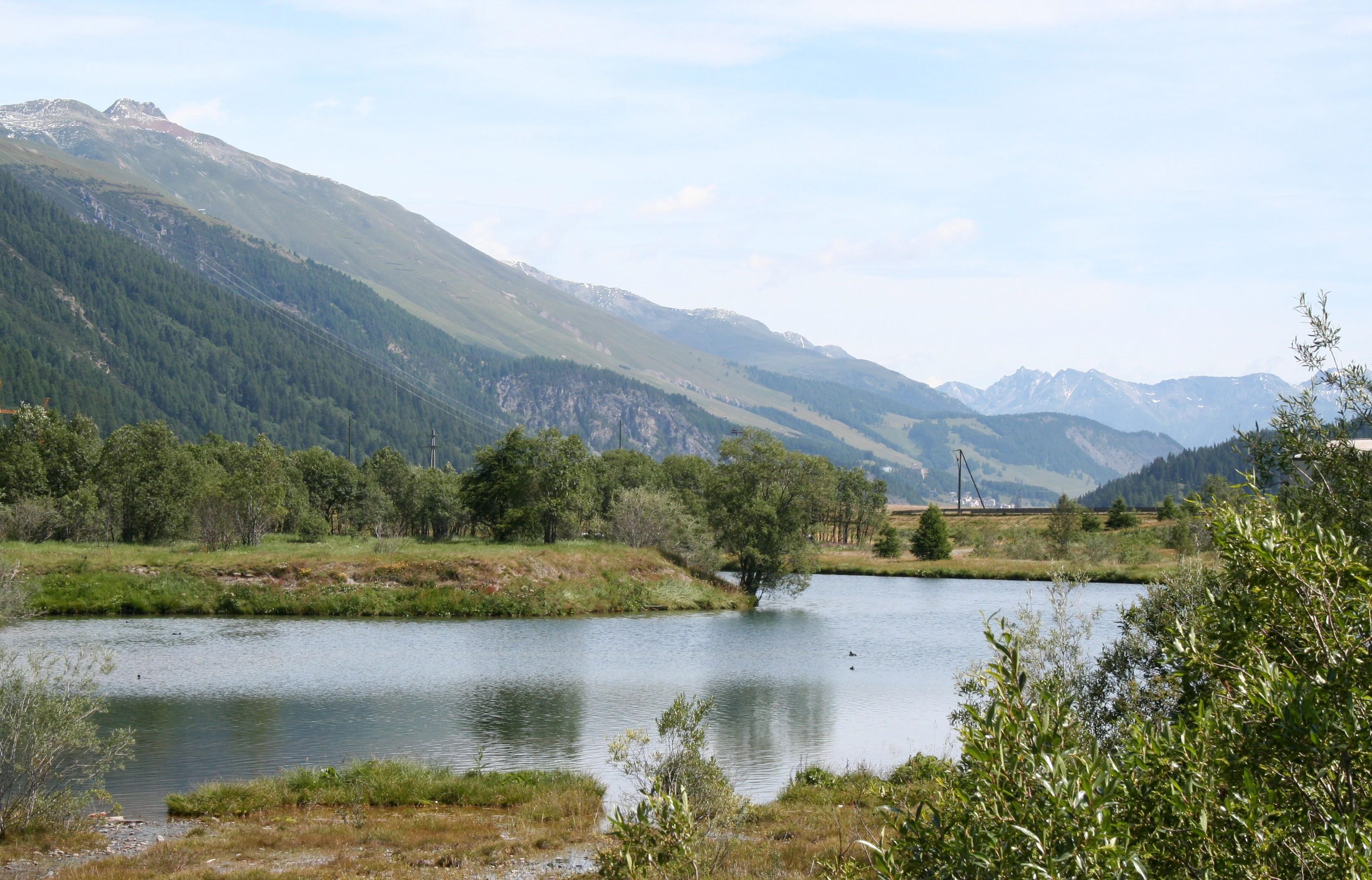
A peaceful lake in the foreground surrounded by marshy vegetation, with gentle rolling hills and mountains in the background under a pale sky.
The tranquil waters of Lej da Gravatscha, situated within the Isla Glischa-Arvins-Seglias nature reserve in the Engadin valley.

Isla Glischa-Arvins-Seglias Nature Reserve history and protected-area timeline

The history of Isla Glischa-Arvins-Seglias is closely tied to the long human effort to manage and modify the Inn River in the Upper Engadin. Local communities began constructing flood protection dams along the Inn and its tributaries as early as the 18th and 19th centuries. The first lateral embankments along the Flaz were built in 1875.

Despite these efforts, periodic flood events continued to cause substantial damage. A particularly severe flood in 1954 prompted major new engineering works. In response, the Inn near Bever was converted into a narrow, straightened canal confined by high embankments, and tributary streams were heavily channelized. While these measures reduced flood risk and expanded agricultural land, they also cut the river off from its natural floodplain. Internal drainage canals dried out much of the former wetland, and the hardened riverbed offered poor habitat for fish and other aquatic species.

In 1992, recognizing the ecological importance of the remaining river landscape, Swiss authorities listed the area as a floodplain of national importance, creating the legal foundation for its modern protection. This designation placed the reserve within the Federal Inventory of Floodplains of National Importance and set the stage for future restoration.

Beginning in 2013, a long-term revitalization project has been reshaping the area. Working in multiple construction phases, project partners have been widening the river corridor, reintroducing natural dynamics, removing unnecessary embankments, and relocating key infrastructure to allow the river to spread again across the floodplain. The final phase near La Punt involves moving the cantonal road away from the river over a distance of more than two kilometers, freeing the Arvins area for natural river processes.

Isla Glischa-Arvins-Seglias Nature Reserve landscape and geographic character

The landscape of Isla Glischa-Arvins-Seglias is shaped by the broad, relatively flat floor of the Upper Engadin, where the Inn flows with only a modest gradient of about 15 meters across the reserve. This gentle slope, combined with the valley's glacial history, produced a wide alluvial zone of gravel, sand, and silt that once supported extensive floodplain ecosystems.

Today, the reserve still preserves key features of this classic alpine riverine landscape. Gravel banks, shifting islands, and abandoned channels line the Inn, while side streams such as the Flaz, Ova Chamuera, and Beverin contribute sediment and hydrological variety. The Flaz, which once entered the Inn upstream of Samedan, was redirected through a new near-natural riverbed between 2002 and 2005, and now joins the Inn at 'Gravatscha'.

A distinctive feature of the landscape is the lake Lej da Gravatscha, which formed in a former riverbed where gravel was once extracted. The lake and the surrounding 'gravatscha' gravel area are emblematic of how past human activity has been integrated into a new natural setting. Other landscape elements include the marshes of Palüds-Agnas near Bever, the 14-hectare peatland at Surent Pascul, and the expansive open area around Arvins that is being restored to a more dynamic floodplain. The reserve also contains small ponds, riparian woodlands, wet meadows, and a network of old drainage canals that mark the area's agricultural history.

Two local road bridges near Bever cross the Inn within the reserve, while the main road and the Rhaetian Railway cross the floodplain near La Punt-Chamues-ch. As revitalization progresses, these infrastructural elements are increasingly being adapted or relocated to give the river more space.

Isla Glischa-Arvins-Seglias Nature Reserve ecosystems, habitats, and plant life

The nature of Isla Glischa-Arvins-Seglias is defined by inland floodplain ecosystems typical of high-elevation alpine valleys. The reserve protects a mosaic of aquatic, wetland, riparian, and meadow habitats that reflect the transitional character of the Inn floodplain between aquatic and terrestrial environments.

Core ecological features include the open water and gravel shoreline habitats of the Inn and Lej da Gravatscha, the riparian willow and alder forests along the riverbanks, and the marshy and peat-forming wetlands that occupy low-lying parts of the valley floor. The 14-hectare peatland at Surent Pascul and the amphibian breeding area of Palüds-Agnas near Bever are integral parts of this ecological mosaic. The name 'Palüds' itself comes from the Romansh word for marsh, pointing to the area's long wetland heritage.

The floodplain acts as a critical transition zone between the alpine river system and surrounding dry valley habitats. Periodic flooding, sediment deposition, and groundwater seepage sustain a high diversity of microhabitats. Riverbank gravels provide nesting and feeding areas for specialized bird species, while the slower-moving side channels and ponds offer refuge for amphibians, invertebrates, and fish, especially as revitalization improves habitat connectivity.

The reserve represents an important example of how, even in a strongly engineered valley, restoring the river's natural dynamics can rapidly rebuild ecological complexity. The combination of flowing water, still water, wet meadows, and riparian woodland gives Isla Glischa-Arvins-Seglias high biodiversity value relative to its modest size.

Isla Glischa-Arvins-Seglias Nature Reserve wildlife and species highlights

Wildlife in Isla Glischa-Arvins-Seglias reflects the diversity of habitats that the floodplain offers: open river channels, gravel bars, ponds, marshes, peatlands, riparian forest, and meadows. The Inn and its side waters, particularly around Lej da Gravatscha, are important habitats for waterbirds that use the open water and shoreline for feeding and resting during both breeding and migration seasons.

The marshes near Bever, particularly the Palüds-Agnas area, are nationally recognized as an important amphibian breeding site. These wetlands provide critical spawning habitat for frogs and other amphibians that depend on shallow, seasonal water bodies. As revitalization reintroduces more dynamic flooding and creates new pools and side channels, amphibian populations are expected to benefit alongside other wetland fauna.

Fish life in the Inn has historically been constrained by channelization and hardened riverbeds. The revitalization project has substantially improved aquatic habitat structure, providing fish with more varied flow conditions, shelter, and spawning areas. Invertebrate communities along gravel banks and side channels also make up an important part of the reserve's fauna, supporting the wider food web that includes birds and amphibians.

Riparian woodland and meadow habitats host typical Engadin bird and small mammal species adapted to seasonally flooded environments, while the peatland at Surent Pascul supports species associated with moist, nutrient-poor ground conditions. Although the reserve does not host the large charismatic mammals more typical of mountain wilderness areas, its ecological richness lies in the diversity of smaller, often overlooked species that depend on dynamic floodplain processes.

Isla Glischa-Arvins-Seglias Nature Reserve conservation status and protection priorities

Isla Glischa-Arvins-Seglias holds an important place in Swiss floodplain conservation. Designated in 1992, it is part of the Federal Inventory of Floodplains of National Importance, a federal instrument that recognizes floodplain sites of significant ecological value and subjects them to national protection standards.

The reserve's conservation value lies in its combination of rare and threatened habitat types, including alpine river floodplains, riparian forests, gravel lakes, peatlands, and amphibian breeding sites. The presence of a nationally important amphibian spawning area at Palüds-Agnas and the 14-hectare peatland at Surent Pascul underlines the reserve's role in protecting species and habitats that are otherwise scarce in the highly developed Upper Engadin.

The long-running revitalization program is central to the reserve's conservation significance. Past flood-control engineering, especially after the 1954 flood, had reduced the river to a narrow channel and drained surrounding wetlands, fragmenting ecological processes. The restoration project launched in 2013 aims to reverse this by widening the river corridor, reactivating floodplain dynamics, reconnecting side channels, and allowing the river to create new habitats naturally.

Beyond ecological restoration, the project also reconnects flood protection with habitat creation, demonstrating how flood retention areas can serve both human safety and biodiversity goals. The reserve thus serves as a model for integrating river engineering, land use, and ecological recovery in a densely settled alpine valley.

Isla Glischa-Arvins-Seglias Nature Reserve cultural meaning and human context

The cultural dimension of Isla Glischa-Arvins-Seglias is rooted in the Romansh-speaking heritage of the Upper Engadin. The reserve's name itself is drawn from local place names that reflect long familiarity with the river landscape: 'Isla Glischa' refers to flat, island-like areas near the river, while 'Arvins' and 'Seglias' are historic land parcels at the northern end of the floodplain. Romansh words such as 'isla' (island), 'glischa' (flat, slippery), 'palüd' (marsh), and 'grava' (gravel, alluvial material) are preserved in local place names and offer a vivid linguistic record of the valley's natural character.

The floodplain has long been part of the Engadin's agricultural and settlement landscape. Communities have shaped the river for centuries through flood-control works, drainage of wetlands for pasture and crop cultivation, and gravel extraction for construction. Some of these interventions, such as the gravel pit that later became Lej da Gravatscha, have become integral features of today's reserve.

The area also plays a seasonal cultural role. In winter, cross-country ski trails run through the floodplain, including the route of the famous Engadin Skimarathon, which crosses the reserve near Gravatscha every March. This connection between a nationally important ecological site and a major regional cultural event underscores how deeply the Inn floodplain is woven into the identity and daily life of the Upper Engadin.

Top sights and standout views in Isla Glischa-Arvins-Seglias Nature Reserve

Isla Glischa-Arvins-Seglias stands out for combining nationally protected floodplain status with one of the most ambitious river restoration programs in the Swiss Alps. Its scale within the Upper Engadin, its link to the Inn and its key tributaries, and its rich mosaic of gravel lakes, riparian forest, peatland, and marsh habitats give it a distinctive ecological profile.

Key highlights include the gravel lake Lej da Gravatscha, the nationally important amphibian breeding area at Palüds-Agnas, the peatland at Surent Pascul, and the expansive, increasingly dynamic floodplain near Arvins. The ongoing revitalization works, including the planned relocation of several kilometers of cantonal road near La Punt, make the reserve a living laboratory for floodplain restoration in an alpine setting.

Best time to visit Isla Glischa-Arvins-Seglias Nature Reserve

Isla Glischa-Arvins-Seglias is best experienced during the warmer months, when the dynamic character of the floodplain is most visible. Late spring and summer bring active river flows, lush riparian vegetation, and the peak breeding and feeding activity of waterbirds and amphibians in the ponds and marshes. These seasons also offer the best conditions for observing ongoing restoration work and the evolving river channels.

Winter gives the reserve a very different character. A cross-country ski trail runs through parts of the floodplain, including the route of the Engadin Skimarathon in March, when the wide, open valley floor becomes a major venue for a regional sporting and cultural event. Visitors interested in wetland ecology, riparian forest, or floodplain dynamics will find the most rewarding experience between late spring and early autumn.

Monthly climate preview

Long-term temperature and precipitation patterns from a representative high-elevation coordinate

Naturschutzgebiet Isla Glischa-Arvins-Seglias Climate and Monthly Weather Normals

Representative coordinate measurements reveal the multi-year temperature and precipitation rhythm across twelve recorded intervals at Naturschutzgebiet Isla Glischa-Arvins-Seglias. Detailed monthly comparisons provide deeper context for studying the long-term climate normals and seasonal variations associated with this protected area.
Annual mean0 °C
-10 °C11 °C
Jan-10°
Feb-10°
Mar-6°
Apr-1°
May
Jun
Jul11°
Aug10°
Sep
Oct
Nov-4°
Dec-9°
Warmest month
July

10.6 °C

Coolest month
January

-10.1 °C

Wettest month
June

4.4 mm/day

Driest month
February

1.5 mm/day

Park location guide

Geography guide, regional context, and park location map for Isla Glischa-Arvins-Seglias Nature Reserve

Isla Glischa-Arvins-Seglias Nature Reserve park geography, regions, and map view in Switzerland

Understand where Isla Glischa-Arvins-Seglias Nature Reserve sits in Switzerland through a broader geographic reading of the surrounding landscape, nearby location context, and its mapped position within the national park landscape.

How Isla Glischa-Arvins-Seglias Nature Reserve fits into Switzerland

Switzerland is a landlocked federal republic in Central Europe comprising 26 cantons, with Bern as the federal city and Zurich as the largest city. The country features the Swiss Alps, Swiss Plateau, and Jura Mountains, with German, French, Italian, and Romansh as official languages. It is noted for its political neutrality, direct democracy traditions, and strong economy.

Wider geography shaping Isla Glischa-Arvins-Seglias Nature Reserve in Switzerland

Switzerland is located in Central Europe at the intersection of Western and Southern Europe. It is bordered by Germany to the north, France to the west, Austria and Liechtenstein to the east, and Italy to the south. The country is geographically divided among the Swiss Alps (covering most of the territory), the Swiss Plateau (where most of the population resides), and the Jura Mountains. Switzerland is landlocked.

Map view of Isla Glischa-Arvins-Seglias Nature Reserve

Use this park location map to pinpoint Isla Glischa-Arvins-Seglias Nature Reserve in Switzerland, understand its exact geographic position, and read its mapped placement within the surrounding landscape more clearly.

Pigeon | © OpenStreetMap contributors

Location context for Isla Glischa-Arvins-Seglias Nature Reserve

Graubünden

Visualizing alpine river floodplains, gravel lakes, and restored riparian habitats

Naturschutzgebiet Isla Glischa-Arvins-Seglias Landscape Photography and Scenery

Visual documentation reveals the shifting gravel banks, winding river channels, and diverse wetland habitats of Naturschutzgebiet Isla Glischa-Arvins-Seglias. Examining these protected-area photographs provides a clearer understanding of alpine river restoration and floodplain morphology.

A peaceful lake in the foreground surrounded by marshy vegetation, with gentle rolling hills and mountains in the background under a pale sky.

A mountain river confluence showing a smaller, fast-flowing stream entering a larger, light-blue glacial river with surrounding alpine forests and valley slopes.

Park atlas

Compare adjacent alpine river reserves, alpine wetlands, and regional protected areas in the Engadin valley.

Other Parks Near Naturschutzgebiet Isla Glischa-Arvins-Seglias and Surrounding Protected Landscapes

Browsing other parks near Naturschutzgebiet Isla Glischa-Arvins-Seglias reveals connected alpine valley ecosystems, river floodplanes, and wetland reserves throughout Graubünden. Expanding the geographical comparison provides broader context on regional conservation corridors and alpine river restoration projects.
National parkGraubünden
About 11 km away#1 closest

Northeast

Swiss National Park: Geographic Context and Protected Alpine Wilderness in Graubünden

A comprehensive look at the Engadin valley's premier wilderness sanctuary

Spanning over 170 square kilometers in the canton of Graubünden, the Swiss National Park offers an unparalleled example of a strictly protected Alpine ecosystem. This atlas profile details the park's distinct topography, from the subalpine pine forests near the Ofenpass to the delicate karst lake basins at Macun, providing a deep look into its history as a central reference site for wilderness restoration and geological research.

Area
170.3 km²
Established
1914
IUCN
Ia
Relief
Mountain
Watercolor painting of a mountain range with a lake, green hills, and a sunset sky
National parkTrentino-Alto Adige/Südtirol
About 13 km away#2 closest

East

Stelvio National Park National Park: Protected Landscape and Regional Geographic Context

Explore its mapped boundaries and natural terrain.

Navigate Stelvio National Park, a designated national park in Italy's Trentino-Alto Adige/Südtirol region, through a map-centric lens. This page provides critical context for understanding the park's protected landscape, its geographic position within the Alps, and its mapped terrain. Utilize MoriAtlas to grasp the park's boundaries and its place in regional geography for structured natural landscape discovery.

Established
1935
IUCN
II
Relief
Mountain
Scope
Terrestrial
Watercolor illustration of a panoramic mountain landscape with soft green hills, rolling ridgelines in shades of pink and purple, and small patches of blue water in the foreground.
Regional parkCanton of Graubünden
About 17 km away#3 closest

West

Parc Ela: Regional Nature Park and Alpine Geography in the Canton of Graubünden

A vertical protected landscape in the Swiss Alpine arc.

Parc Ela encompasses a remarkable span of Swiss Alpine geography, protecting everything from low-lying forested gorges at seven hundred meters to high-altitude peaks over three thousand meters. The park serves as a vital refuge for threatened insect species and large alpine mammals, while preserving the linguistic and architectural heritage of the Albula and Oberhalbstein valleys. Explore the mapped terrain where paleontological treasures meet historic trade routes.

Area
659 km²
Established
2012
Relief
Mountain
Climate
Alpine
A horizontal watercolor illustration showing stylized, overlapping mountain ridges in shades of soft green, pink, and yellow against a white background.
Natural monumentGraubünden
About 21 km away#4 closest

South

Roseggletscher Natural Monument: Alpine Glacier Geography and Proglacial Lake Mapping

Protected landscape data for the Bernina range in Graubünden.

Examine the geographic boundaries and terrain of the Roseggletscher, a protected natural monument situated in the upper Val Roseg. This record captures its glacial extent, the emergence of the Lej da Vadret proglacial lake, and its role within the wider Bernina glacier ensemble of southeastern Switzerland.

Area
6.38 km²
Relief
Mountain
Climate
Alpine
Access
Moderate access
A soft watercolor painting showing a wide, high-altitude alpine plateau with rolling hills, scattered small lakes, and distant mountain ridgelines.
Nature reserveGraubünden
About 25 km away#5 closest

Northeast

Macun-Seen Nature Reserve: Protected Alpine Plateau and Cirque Lake Landscape

High-altitude basin and crystalline geological features in Graubünden

Located in the Lower Engadine region of Graubünden, the Macun-Seen nature reserve is a significant high-altitude basin formed by glacial action. This protected exclave contains 23 small cirque lakes across a silicate plateau, offering a distinct ecological profile and expansive views of peaks approaching 3000 metres. It stands as a prime example of preserved alpine terrain within the broader Swiss National Park context.

Area
3.6 km²
Established
2000
Relief
Mountain
Climate
Alpine
Regional parkGraubünden
About 29 km away#6 closest

West

Naturpark Beverin: Exploring Alpine Gorges and Cultural Landscapes in Graubünden

A regional nature park shaped by high alpine ridges and ancient settlement traditions.

Naturpark Beverin encompasses a vast, multi-layered environment in the Swiss Alps. The area is defined by the sharp vertical contrast between carved river gorges like the Viamala and high-elevation ridges. Beyond the rugged mountain terrain, this protected landscape preserves centuries of pastoral history through the distinct settlement traditions of its Romanesque and Walser valleys.

Area
515 km²
Established
2013
Relief
Mountain
Climate
Alpine
A soft, horizontal watercolor painting showing rolling green hills, a winding river or lake, and misty mountain silhouettes in the background against a white backdrop.
Regional parkGraubünden
About 36 km away#7 closest

East

Biosfera Val Müstair Regional Park: Alpine Landscapes and UNESCO Biosphere Geography

Protected glacial terrain and cultural alpine valleys in eastern Switzerland.

Discover the distinctive natural geography of Biosfera Val Müstair, where a dry inner-Alpine climate meets high-altitude glacial features like the Lai da Rims. This regional park protects an extensive area of Graubünden, balancing rare ecosystems, broad alluvial fans, and the traditional alpine economy of the Romansh-speaking community.

Area
198.65 km²
Established
2011
Relief
Mountain
Climate
Alpine
Nature reserveLombardia
About 39 km away#8 closest

Southwest

Val di Mello Nature Reserve: Mapping the Granitic Geography of the Italian Alps in Lombardia

A study of protected vertical relief, glacial cirques, and Alpine terrain.

Val di Mello offers a profound look at high-altitude Alpine geography, characterized by its immense, light-colored granitic walls and deeply carved tributary valleys. This protected nature reserve acts as a gateway to the broader mountainous terrain of the Lombardia region, showcasing the geological evolution of the Italian Alps through its steep gullies, high summits, and expansive valley floor.

Established
2009
Relief
Mountain
Access
Moderate access
Scope
Terrestrial

Common questions about visiting, size, designation, and location context for Isla Glischa-Arvins-Seglias Nature Reserve

Isla Glischa-Arvins-Seglias Nature Reserve FAQs for park facts, access, geography, and protected area context

Find quick answers about Isla Glischa-Arvins-Seglias Nature Reserve, including protected-area facts, park geography, trail and visitor context, and how the park fits into its surrounding country and regional landscape.
MoriAtlas Explorer

Continue Your Protected Areas Search Across the Global Atlas

Deepen your exploration by continuing the structured search for national parks and protected areas worldwide. Utilize the comprehensive filtering capabilities to compare different conservation landscapes and refine your understanding of global park geography. Discover more about the distribution and characteristics of protected natural areas.

Global natural geography