

Mori Atlas logo
National parkIvindo National Park

Mapping the vast rainforest, mountainous terrain, and river ecosystems of this UNESCO site.

Ivindo National Park: Gabon's Protected Landscape and Waterfall Wonders

(Parc national d'Ivindo)

Ivindo National Park, a vital protected area in east-central Gabon, encompasses nearly 3,000 square kilometers of biologically significant tropical rainforest. Established in 2002, this UNESCO World Heritage Site is centered around the Ivindo River, featuring dramatic topography and the iconic Kongou and Mingouli waterfalls. Users can explore its mapped boundaries, understand its regional geographic context within Gabon, and discover the unique natural landscapes that define this critical conservation zone.

Tropical RainforestUNESCO World Heritage SiteWaterfallNational ParkCentral AfricaCongo Basin

Ivindo National Park

National park

Park overview

Structured park overview, official facts, and landscape profile for Ivindo National Park

Ivindo National Park park facts, protected area profile, and essential visitor context

Review the core facts for Ivindo National Park, including designation, size, terrain, visitor scale, habitats, and operating context in one park-focused overview.

About Ivindo National Park

Ivindo National Park represents one of Gabon's most significant protected areas and a cornerstone of Central African conservation. Located in the heart of the Congo Basin, the park encompasses a remarkable diversity of tropical ecosystems ranging from lowland rainforest to gallery forests and the dramatic river systems that define its character. The Ivindo River, the park's central waterway and principal tributary to the Ogooué River, has carved a path through the landscape creating the spectacular waterfalls that have made the park famous worldwide. Beyond its natural beauty, Ivindo serves as a critical buffer zone between human settlement areas and the pristine forest interior, with the nearest city of Makokou located just north of the park boundary. The park's 2002 establishment reflected Gabon's commitment to preserving its extraordinary natural heritage, and its 2021 UNESCO World Heritage inscription acknowledged its global significance for biodiversity conservation. The combination of dramatic waterfalls, intact forest ecosystems, and exceptional wildlife populations makes Ivindo one of Africa's most important protected areas.

Quick facts and research context for Ivindo National Park

Ivindo National Park covers 300,000 hectares of nearly continuous tropical forest in east-central Gabon, straddling two provinces. The park was established in 2002 as part of Gabon's ambitious national parks system expansion. It contains the dramatic Kongou Falls on the Ivindo River, one of Central Africa's most powerful waterfalls. The park includes Langoué Baï, one of the five most important forest clearings in Central Africa, and the Ipassa Makokou Biosphere Reserve. Average annual rainfall reaches 1,672 millimeters with temperatures averaging 23.9 degrees Celsius. The park serves as critical habitat for forest elephants, western lowland gorillas, chimpanzees, and over 430 recorded bird species.

Protection and recognition

Documenting the terrestrial boundaries and official global recognition of the protected landscape.

Ivindo National Park Protection Status and UNESCO World Heritage Recognition

Map-based exploration of Ivindo National Park reveals its official terrestrial designation and structural protection profile established in 2021. Geographic records integrate the official UNESCO World Heritage status to provide a complete overview of the park's documented conservation framework.

International recognition

Protection details

Protection scope
Terrestrial
Designated year
2021
Transboundary protection
No
Park context

Deeper park guide and search-rich context for Ivindo National Park

Ivindo National Park history, landscape, wildlife, and travel context

Explore Ivindo National Park through its history, landscape character, ecosystems, wildlife, conservation priorities, cultural context, and seasonal travel timing in a structured park guide built for atlas discovery and search intent.

Why Ivindo National Park stands out

Ivindo National Park is renowned for the spectacular Kongou Falls and Mingouli waterfalls along the Ivindo River, described as the wonders of Ivindo, which constitute one of Central Africa's most dramatic natural spectacles. The park also contains Langoué Baï, a renowned forest clearing that provides exceptional wildlife viewing opportunities and serves as one of the most significant bai ecosystems in Central Africa. The park protects one of the last relatively intact populations of forest elephants in the region, alongside significant populations of western lowland gorillas and common chimpanzees. The diverse freshwater ecosystems, particularly around the waterfalls, support unique aquatic flora including at least seven species of Podostemaceae riverweeds, with each waterfall pool potentially containing distinct plant communities.

Ivindo National Park history and protected-area timeline

Ivindo National Park was officially announced in August 2002 by President Omar Bongo at the Earth Summit in Johannesburg, forming part of a groundbreaking expansion of Gabon's national park system that created 13 terrestrial protected areas across the country. Prior to the park's formal creation, the Wildlife Conservation Society began studying and protecting the southern region around Langoué Baï starting in 2001, establishing an early conservation presence in the area. In 2004, the WCS constructed a purpose-built research camp approximately three kilometers from Langoué Bai, providing accommodation and facilities for researchers studying bai ecology and maintaining a protective presence against poaching activities. The Institut de Recherche en Écologie Tropicale, a tropical research institute under Gabon's national scientific research authority, operates within the northern portion of the park approximately 12 kilometers from Makokou. The park's global recognition came in 2021 when UNESCO inscribed Ivindo as a World Heritage Site based on natural criteria (ix) and (x), recognizing both the outstanding biodiversity and the relatively intact nature of its tropical forest ecosystem.

Ivindo National Park landscape and geographic character

The physical geography of Ivindo National Park features a dramatic combination of mountainous terrain, river valleys, and dense forest cover. The park's highest points include Mount Kingué reaching 749 meters above sea level and Mount Ngouadi at 870 meters, providing significant topographic variation across the protected area. The Ivindo River, the central geographic feature, flows through the park as the principal tributary to the Ogooué River, Gabon's largest waterway. The river's course creates the spectacular Kongou and Mingouli waterfalls that rank among Central Africa's most impressive aquatic features. The landscape includes the Ipassa Plateau, an area known for seasonal severe thunderstorm activity that can occasionally generate localized tornadoes, a meteorological phenomenon that has influenced forest structure and created areas with secondary forest characteristics. The terrain supports diverse habitats from riverine corridors to slopes and plateaus, all covered by the continuous tropical forest that defines the Central African landscape.

Ivindo National Park ecosystems, habitats, and plant life

The ecological character of Ivindo National Park is defined by its extensive old-growth forests spanning both Atlantic coastal forest of Lower Guinea and semi-deciduous forest typical of the central Congo Basin. The park's nearly 300,000 hectares of continuous forest cover represents one of the most intact tropical forest ecosystems in the region. The southern portions contain geographically unique populations of Caesalpinioideae, commonly known as the peacock flower subfamily, which support exceptional butterfly diversity. The numerous streams and waterfalls within the park have driven the diversification of freshwater species, with at least seven species of Podostemaceae riverweeds documented and each waterfall pool potentially harboring unique aquatic plant communities. The Didji River system provides critical habitat for the endangered slender-snouted crocodile, while 13 threatened fish species depend on the park's aquatic environments. The climate features average rainfall of 1,672 millimeters annually with distinct wet seasons from September to December and February to May, supporting the lush forest ecosystem.

Ivindo National Park wildlife and species highlights

Ivindo National Park supports an exceptional array of mammalian species characteristic of intact Central African forest ecosystems. The park contains significant populations of western lowland gorillas and common chimpanzees, two of Africa's most iconic primate species. Forest elephants, among the last relatively intact populations in Central Africa, regularly traverse the park's forest and visit the Langoué Baï clearing. Other notable mammals include African forest buffalo, red river hog, sitatunga, and the elusive African golden cat. The bird diversity is equally remarkable, with over 430 species recorded within the park boundaries. Particularly significant are the endangered grey-necked rockfowl and grey parrot, species of high conservation concern that find essential habitat within Ivindo's forests. The aquatic environments support at least 13 threatened fish species and provide critical habitat for the endangered slender-snouted crocodile. The Langoué Baï forest clearing offers exceptional opportunities to observe wildlife congregating at these natural clearings, a phenomenon that makes the park particularly valuable for wildlife research and viewing.

Ivindo National Park conservation status and protection priorities

Ivindo National Park represents a critical component of Gabon's conservation strategy and global biodiversity protection efforts. The park's designation as a UNESCO World Heritage Site in 2021 recognizes its outstanding universal value as one of the last relatively intact tropical forest ecosystems in Central Africa. The park's inclusion of the Ipassa Makokou Biosphere Reserve and the protection of Langoué Baï, one of Central Africa's five most important forest clearings, demonstrates its multifaceted conservation significance. Long-term research and protection efforts by the Wildlife Conservation Society since 2001 have provided important ecological insights and anti-poaching presence, particularly in the southern regions around Langoué Bai. The presence of significant populations of forest elephants, western lowland gorillas, and other threatened species places Ivindo at the forefront of great ape conservation. The park's diverse freshwater ecosystems and unique aquatic flora require ongoing protection to maintain the ecological processes that support the remarkable biodiversity found within its boundaries.

Ivindo National Park cultural meaning and human context

Ivindo National Park is situated in a region with rich indigenous heritage, though the park's primary designation focuses on biodiversity conservation rather than explicit cultural landscape protection. The park straddles two provinces, Ogooué-Ivindo and Ogooué-Lolo, in east-central Gabon, an area historically inhabited by various Bantu-speaking communities whose traditional relationship with the forest and river systems has shaped the landscape over generations. The park's establishment in 2002 represented part of a broader national initiative to balance conservation with sustainable development, with the nearby city of Makokou serving as a regional center for research and park management activities. The Ipassa Makokou Biosphere Reserve within the park boundaries reflects an integrated approach to conservation that considers both ecological and human dimensions of the landscape. Research institutions operating within the park, including the Institut de Recherche en Écologie Tropicale near Makokou and the WCS Langoué Research Station, contribute to scientific understanding while maintaining connections to local communities and traditional ecological knowledge.

Top sights and standout views in Ivindo National Park

The spectacular Kongou and Mingouli waterfalls on the Ivindo River represent the park's most dramatic natural features and are widely celebrated as the wonders of Ivindo. Langoué Baï provides exceptional wildlife viewing opportunities at one of Central Africa's five most important forest clearings, where visitors may observe forest elephants, gorillas, and other species. The park protects one of the last relatively intact populations of forest elephants in Central Africa, a species facing severe pressure across its range. Over 430 bird species have been recorded, including the endangered grey-necked rockfowl and grey parrot. The unique Podostemaceae riverweed communities in waterfall pools represent specialized aquatic ecosystems found nowhere else in such concentration. The 2021 UNESCO World Heritage inscription acknowledges the park's global significance for biodiversity conservation.

Best time to visit Ivindo National Park

The optimal time to visit Ivindo National Park coincides with the drier periods when wildlife viewing opportunities are most favorable. The primary dry season from June to August typically offers easier access to trail systems and clearer visibility at forest clearings like Langoué Baï. However, visitors should be prepared for the park's equatorial climate, which maintains relatively warm temperatures throughout the year averaging around 24 degrees Celsius. The wet seasons from September to December and February to May bring higher rainfall, which can affect trail conditions and access but also enhance the dramatic waterfall flows that define the park's character. The periods immediately following rainfall can offer exceptional wildlife activity as animals become more active in the refreshed environment. Whatever the season, visitors should be prepared for the humid tropical conditions and the remote nature of this wilderness area.
Monthly climate preview

Long term temperature trends and average monthly precipitation in Gabon's forested interior

Monthly Climate Normals and Weather Patterns in Ivindo National Park

Historical weather data from a representative elevation of 422 meters reveals consistently warm equatorial temperatures alongside distinct wet and dry precipitation periods. Accessing the complete twelve-month profile provides detailed weather-by-month averages of daily rainfall and temperature bounds across the annual cycle.
Annual mean24 °C
24 °C25 °C
Jan25°
Feb25°
Mar25°
Apr25°
May25°
Jun24°
Jul24°
Aug24°
Sep24°
Oct24°
Nov24°
Dec25°
Warmest month
February

25.1 °C

Coolest month
October

23.8 °C

Wettest month
November

8.9 mm/day

Driest month
July

0.9 mm/day

Park location guide

Geography guide, regional context, and park location map for Ivindo National Park

Ivindo National Park park geography, regions, and map view in Gabon

Understand where Ivindo National Park sits in Gabon through a broader geographic reading of the surrounding landscape, nearby location context, and its mapped position within the national park landscape.

How Ivindo National Park fits into Gabon

Gabon is a Central African country on the Atlantic coast, positioned on the equator. It gained independence from France in 1960 and is governed as a unitary presidential republic. The country has significant oil wealth and one of the highest Human Development Index rankings in Africa, though wealth distribution remains uneven.

Wider geography shaping Ivindo National Park in Gabon

Gabon is situated on the Atlantic coast of Central Africa, positioned along the equator. It borders Equatorial Guinea to the northwest, Cameroon to the north, and the Republic of the Congo to the east and south. The terrain includes coastal plains along the Atlantic, mountain ranges in the center (the Cristal Mountains and Chaillu Massif), and savanna zones in the east.

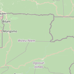
Map view of Ivindo National Park

Use this park location map to pinpoint Ivindo National Park in Gabon, understand its exact geographic position, and read its mapped placement within the surrounding landscape more clearly.

Pigeon | © OpenStreetMap contributors

Location context for Ivindo National Park

Ogooué-Ivindo ProvinceOgooué-Lolo Province
Park atlas

Map protected landscapes and compare adjacent national park geography throughout Gabon and the broader Central African region.

Discover More National Parks and Protected Areas Surrounding Ivindo National Park

Continue your exploration beyond Ivindo National Park by browsing other significant national parks and protected areas within Gabon and the wider Central African region. Compare diverse ecosystems, trace connected protected landscapes, and understand the regional spread of conservation efforts, providing richer context for Ivindo's unique features.
Biosphere reserveGabon
About 51 km away#1 closest

North

Ipassa-Makokou Biosphere Reserve: Gabon Geographic and Ecological Profile

Protected tropical lowland forest along the Ivindo River

Situated in northeastern Gabon, the Ipassa-Makokou Biosphere Reserve protects a vital segment of the Congolese-Guinean rainforest. This area provides deep insight into forest dynamics through decades of consistent monitoring, showcasing an unbroken canopy and high biodiversity density within a key Central African corridor.

Area
150 km²
Established
1983
Watercolor painting of a landscape with grassy areas, a lake, and distant hills under a light sky
National parkGabon
About 98 km away#2 closest

Southwest

Lopé National Park: Gabon's Protected Landscape and National Park Geography

Explore mapped boundaries and natural terrain in Central Africa.

Delve into Lopé National Park, a designated national park situated in Gabon. This protected area serves as a crucial point for understanding the nation's geography and the distribution of its conservation landscapes. As an entry in the MoriAtlas, it offers a detailed view of its mapped territory and its contribution to the broader regional context of Central Africa, emphasizing its role in protected area atlas exploration.

Area
4,910 km²
Established
2002
IUCN
II
Relief
Mixed relief
National parkGabon
About 120 km away#3 closest

North

Minkébé National Park: Protected Area and Geographic Context in Gabon

Explore the mapped terrain and protected landscape of this national park.

Gain a structured understanding of Minkébé National Park, a designated national park situated in Gabon. This destination focuses on the park's protected landscape, its distinct mapped boundaries, and its contribution to the regional geography of Central Africa. Examine how its protected status shapes the natural terrain and offers a unique angle for geographic discovery.

Area
7,570 km²
Established
2002
IUCN
II
Relief
Upland
National parkGabon
About 135 km away#4 closest

East

Mwangné National Park: Gabon's Protected Landscape for Geographic Discovery

Explore the mapped boundaries and regional context.

Gain a detailed understanding of Mwangné National Park, a key protected area within Gabon. This page offers an atlas-centric view, highlighting its geographic significance and the characteristics of its protected landscape. Delve into the park's mapped boundaries and its role within the broader natural terrain of Central Africa, providing essential context for geographic exploration.

National parkEquatorial Guinea
About 206 km away#5 closest

Northwest

Altos de Nsork National Park: Equatorial Guinea's Protected Landscape and Map Context

Explore the mapped boundaries of this national park.

Altos de Nsork National Park stands as a designated national park within Equatorial Guinea, offering a distinct protected landscape. This entry provides essential atlas-driven details, emphasizing its geographic setting and mapped park boundaries. Understand its regional context and its significance as part of the conservation network in Central Africa, contributing to a richer understanding of mapped natural terrains.

Area
700 km²
Established
2000
IUCN
II
Relief
Highland
National parkGabon
About 207 km away#6 closest

Southwest

Waka National Park: A Mapped Protected Landscape in Gabon's Geography

Explore the natural terrain and park boundaries of this national park.

Waka National Park in Gabon represents a vital protected landscape for geographic exploration. This dedicated detail page offers insight into the park's specific mapped area and its place within the country's broader natural terrain. Understand its context as a national park, contributing to the atlas of protected areas in Central Africa. Discover the geographic identity of this significant natural reserve.

Area
1,060 km²
Established
2002
IUCN
II
Relief
Mountain
National parkGabon
About 209 km away#7 closest

South

Birougou National Park: Mapped Protected Landscape and Regional Geography in Gabon

Explore the geographic extent and conservation context of this national park.

Birougou National Park is an important protected area situated in Gabon, offering a distinct focus for geographic and atlas-based discovery. This national park serves as a significant element within the country's network of conservation landscapes, providing a focal point for understanding mapped terrain and regional geographic patterns. Users can explore its protected boundaries and gain insight into its specific environmental context within Central Africa, making it a vital entry for atlas exploration of Gabon's natural heritage.

Area
690 km²
Established
2002
IUCN
II
Relief
Mountain
Protected areaGabon
About 210 km away#8 closest

South

Parc de la Lékédi: Protected Area Geography and Landscape Context in Southeastern Gabon

A managed savanna and forest mosaic reserve in the Haut-Ogooué province.

Spanning 14,000 hectares of sandstone terrain, Parc de la Lékédi represents a distinct protected landscape in Gabon. The reserve merges conservation goals with scientific research on primates, utilizing a network of lakes and riverine corridors that support a high concentration of forest and savanna species in a highly managed, ecologically significant environment.

Area
140 km²
Established
1990
Relief
Upland
Climate
Tropical

Common questions about visiting, size, designation, and location context for Ivindo National Park

Ivindo National Park FAQs for park facts, access, geography, and protected area context

Find quick answers about Ivindo National Park, including protected-area facts, park geography, trail and visitor context, and how the park fits into its surrounding country and regional landscape.
MoriAtlas Explorer

Continue Your Protected Areas Search Across the Global Atlas

Deepen your exploration by continuing the structured search for national parks and protected areas worldwide. Utilize the comprehensive filtering capabilities to compare different conservation landscapes and refine your understanding of global park geography. Discover more about the distribution and characteristics of protected natural areas.

Global natural geography
