

Mori Atlas logo
National parkKanha National Park

Discover the geographic extent and mapped boundaries of this protected natural landscape in Madhya Pradesh.

Kanha National Park: India's National Park Landscape and Protected Area Map

(Kanha-Kisli National Park)

Kanha National Park stands as a significant protected area within India's Madhya Pradesh region. This page provides detailed atlas context, focusing on the park's geographic setting and its mapped protected landscape. Users can explore the precise boundaries and understand Kanha National Park's place within the national atlas of conservation lands, offering a factual basis for geographic discovery and landscape analysis.

tiger reservenational parkdeciduous forestcentral IndiaBengal tigerwildlife conservation

Kanha National Park

National park

Park overview

Structured park overview, official facts, and landscape profile for Kanha Tiger Reserve

Kanha Tiger Reserve park facts, protected area profile, and essential visitor context
Review the core facts for Kanha Tiger Reserve, including designation, size, terrain, visitor scale, habitats, and operating context in one park-focused overview.

About Kanha Tiger Reserve

Kanha Tiger Reserve stands as a testament to India's commitment to wildlife conservation, representing the largest national park in central India and one of the most significant tiger habitats in the world. The reserve's creation traces back to 1933 when it was established as a wildlife sanctuary, later achieving national park status in 1955 and tiger reserve designation in 1973 under Project Tiger. The park encompasses two core protected areas known as Hallon and Barron, spanning 250 and 300 square kilometers respectively, surrounded by a buffer zone that extends the conservation footprint to over 1,000 square kilometers. The terrain varies from gentle rolling plains to steep slopes, with the park's forests transitioning from lush sal-dominated lowland areas to bamboo thickets on the higher elevations. The reserve's ecological significance extends beyond its borders, forming part of a contiguous forest complex that supports wildlife corridors connecting to surrounding protected areas and allowing for natural population movement essential for genetic diversity.

Quick facts and research context for Kanha Tiger Reserve

Kanha Tiger Reserve covers 940 square kilometers in central India's Madhya Pradesh state, straddling the Mandla and Balaghat districts. It forms part of the larger Kanha Tiger Reserve complex that includes a buffer zone of 1,067 square kilometers and the neighboring Phen Sanctuary. The park features a mix of lowland sal forests and highland tropical moist deciduous vegetation with bamboo. The reserve is home to Bengal tigers, Indian leopards, barasingha (swamp deer), gaur, sloth bears, dholes, and approximately 300 bird species. Kanha was the first tiger reserve in India to introduce an official mascot, Bhoorsingh the Barasingha, highlighting the conservation significance of this endangered deer species.

Park context

Deeper park guide and search-rich context for Kanha Tiger Reserve

Kanha Tiger Reserve history, landscape, wildlife, and travel context
Explore Kanha Tiger Reserve through its history, landscape character, ecosystems, wildlife, conservation priorities, cultural context, and seasonal travel timing in a structured park guide built for atlas discovery and search intent.

Why Kanha Tiger Reserve stands out

Kanha is best known as one of the finest tiger habitats in India and a model for large carnivore conservation in Asia. The reserve gained particular prominence for its successful barasingha (swamp deer) conservation program, which brought this species back from the brink of extinction within the park. The park's tiger population, while not as dense as some other reserves, benefits from an exceptionally well-protected habitat with abundant prey, making sightings possible during guided safaris. Kanha's landscape of grasslands interspersed with sal forests creates a distinctive savanna-like appearance unusual for central India, providing optimal visibility for wildlife viewing.

Kanha Tiger Reserve history and protected-area timeline

Kanha's history as a protected area began in 1933 when the region was declared a wildlife sanctuary, reflecting early colonial-era recognition of the region's natural wealth. The transformation to a national park in 1955 marked a formal commitment to preserving the area's ecological character, though significant conservation challenges remained. The critical turning point came in 1973 when India launched Project Tiger, and Kanha was selected as one of the original nine tiger reserves, bringing substantial federal funding and protection mechanisms. A significant chapter in the reserve's history involved the relocation of Baiga tribal communities from 28 villages within the park boundaries between 1968 and later years, undertaken to reduce human-wildlife conflict and create a more secure tiger habitat. This relocation, while controversial regarding its implementation and impacts on the displaced communities, enabled the establishment of a core zone largely free of permanent human settlement. The reserve achieved another milestone by becoming the first in India to adopt an official mascot, Bhoorsingh the Barasingha, symbolizing the successful conservation of this endemic deer species.

Kanha Tiger Reserve landscape and geographic character

The physical landscape of Kanha Tiger Reserve presents a compelling combination of forest-covered hills and expansive grassy meadows that create a distinctive visual character. The park's terrain is dominated by low, undulating hills of the Satpura Range, with elevations ranging from approximately 450 to 900 meters above sea level. The valleys and lower slopes support dense stands of sal (Shorea robusta), India's most economically important timber tree, while the higher elevations feature tropical moist deciduous forest with bamboo dominating the understory. Scattered throughout the forest matrix are vast grasslands locally known as 'maidans,' which provide critical foraging habitat for herbivores and excellent visibility for wildlife observation. These open meadows, maintained by a combination of climatic factors and the browsing pressure of herbivores, create the park's characteristic savanna-like appearance. Several seasonal streams and small rivers drain the landscape, providing essential water sources for wildlife during the dry season, while the underlying geology supports diverse soil types that influence vegetation patterns.

Kanha Tiger Reserve ecosystems, habitats, and plant life

The ecological character of Kanha is defined by its tropical dry deciduous forest ecosystem, one of the most extensive and well-preserved examples in central India. The lowland forests consist primarily of sal mixed with other tree species including Indian ghost tree (Sterculia urens), while the slopes and higher ground support bamboo-dominated forest that creates dense, almost impenetrable thickets in some areas. The meadows and grasslands that interrupt the forest cover represent a unique habitat type within the regional context, maintained by local climatic conditions and herbivore pressure. These grasslands support diverse herbaceous plant communities and provide crucial grazing territory for the park's large ungulate populations. The forest structure supports a complex food web, with the bamboo groves particularly important for supporting species like the sloth bear and the barasingha, which seeks the tall grass for cover. The reserve's position within central India places it at the intersection of several biogeographic zones, contributing to its species richness.

Kanha Tiger Reserve wildlife and species highlights

Kanha Tiger Reserve supports an impressive array of mammalian species, with the Bengal tiger serving as the flagship predator and primary conservation focus. The tiger population, while numerically modest compared to some reserves, benefits from abundant prey species including chital (spotted deer), sambar deer, barasingha, and gaur, creating stable predator-prey dynamics. The barasingha, or swamp deer, holds particular significance for Kanha as the species for which the park's mascot Bhoorsingh was created, representing one of India's most successful deer conservation stories. The reserve also supports healthy populations of Indian leopards, dholes (wild dogs), and sloth bears, making it one of the few places in India where visitors can realistically hope to see multiple large carnivore species. The avifauna is equally impressive, with approximately 300 bird species recorded including the Indian peafowl, crested serpent eagle, Indian grey hornbill, and both resident and migratory waterfowl. The grasslands provide crucial habitat for the endangered blackbuck, though this species has become increasingly rare within the reserve.

Kanha Tiger Reserve conservation status and protection priorities

Kanha's conservation significance stems from its role as one of India's original tiger reserves and its successful demonstration of how intensive protection can stabilize and grow large carnivore populations. The reserve's inclusion in Project Tiger in 1973 brought sustained funding and enforcement resources that transformed protection capacity, leading to the recovery of tiger populations from critically low levels in the late 20th century. Conservation efforts have extended beyond tigers to encompass the entire ecosystem, with particular attention given to the barasingha population that was rescued from near-extinction through dedicated habitat management. The WWF-India has worked extensively with the Madhya Pradesh Forest Department on corridor management and human-wildlife conflict mitigation, recognizing that successful tiger conservation requires addressing the needs of surrounding human communities. The challenge of balancing conservation objectives with the rights and welfare of displaced tribal communities, particularly the Baiga people, remains a complex ongoing consideration in the reserve's management philosophy.

Kanha Tiger Reserve cultural meaning and human context

The cultural landscape surrounding Kanha is deeply intertwined with the history of the Baiga tribal communities who traditionally inhabited the forests of central Madhya Pradesh. Prior to the establishment of the reserve's core protected zone, approximately 28 villages of the Baiga people existed within what is now the park boundary, representing centuries of traditional forest-dependent living. The Baiga, a semi-nomadic tribe with distinct cultural practices and ecological knowledge, were relocated beginning in 1968 as part of efforts to consolidate tiger habitat, with the final villages relocated from the core zone in subsequent years. This relocation remains one of the more controversial aspects of the reserve's conservation history, with subsequent reports of inadequate compensation and difficult conditions in the resettlement areas. The cultural context also includes the broader regional heritage of central India, an area with rich traditions of forest stewardship and spiritual connection to natural landscapes that predate formal protected area establishment.

Top sights and standout views in Kanha Tiger Reserve

Kanha's status as the largest national park in central India, its designation as a Project Tiger reserve, its successful barasingha conservation program, and its population of Bengal tigers, Indian leopards, and dholes make it a premier wildlife destination. The park's distinctive landscape of sal forests interspersed with bamboo thickets and expansive grasslands provides exceptional wildlife viewing opportunities. The introduction of India's first official tiger reserve mascot, Bhoorsingh the Barasingha, symbolizes the reserve's commitment to endangered species protection. With approximately 300 bird species and diverse mammalian fauna, Kanha offers comprehensive wildlife experiences throughout the year.

Best time to visit Kanha Tiger Reserve

The optimal time to visit Kanha is during the cooler dry season from October through April, when clear skies and sparse vegetation improve wildlife visibility. November to March offers comfortable temperatures for both morning and afternoon safari excursions, though December and January nights can be quite cold. The summer months of April and May bring intense heat that drives animals to waterholes, sometimes improving sighting opportunities, but the harsh conditions can make extended safaris uncomfortable. The monsoon season from June through September brings heavy rainfall that closes many roads within the park and limits safari operations, though the lush green landscape and emerging vegetation create beautiful scenery for those who visit during this period.
Park location guide

Geography guide, regional context, and park location map for Kanha Tiger Reserve

Kanha Tiger Reserve park geography, regions, and map view in India
Understand where Kanha Tiger Reserve sits in India through a broader geographic reading of the surrounding landscape, nearby location context, and its mapped position within the national park landscape.

How Kanha Tiger Reserve fits into India

India is a South Asian country bordered by the Indian Ocean, Arabian Sea, and Bay of Bengal. It shares land borders with Pakistan, China, Nepal, Bhutan, Bangladesh, and Myanmar. The country has a population of over 1.4 billion people and operates as a federal parliamentary republic with its capital in New Delhi.

Wider geography shaping Kanha Tiger Reserve in India

India occupies the Indian subcontinent in South Asia, bordered by the Arabian Sea to the southwest, the Bay of Bengal to the southeast, and the Indian Ocean to the south. It shares land borders with Pakistan to the west, China, Nepal, and Bhutan to the north, and Bangladesh and Myanmar to the east. The territory also includes the Andaman and Nicobar Islands in the Indian Ocean.

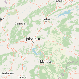
Map view of Kanha Tiger Reserve

Use this park location map to pinpoint Kanha Tiger Reserve in India, understand its exact geographic position, and read its mapped placement within the surrounding landscape more clearly.

Pigeon | © OpenStreetMap contributors

Location context for Kanha Tiger Reserve

Madhya Pradesh
Park atlas

Discover the regional spread of India's diverse protected areas, mapping adjacent tiger reserves and forest habitats for deeper geographic context.

Explore Other National Parks Near Kanha National Park: Compare Central India's Protected Landscapes
Explore national parks and protected areas across Central India, tracing a network of tiger reserves and wildlife sanctuaries sharing tropical dry deciduous forest and grassland ecosystems. Compare these protected landscapes to understand regional conservation efforts, revealing how similar habitats connect beyond Kanha National Park within Madhya Pradesh.
National parkMadhya Pradesh

Ghughua Fossil Park National Park: Mapped Geography and Protected Area Context in Madhya Pradesh

Explore the mapped boundaries and regional landscape of Ghughua Fossil Park.

Ghughua Fossil Park stands as a designated national park within the expansive geography of Madhya Pradesh, India. This resource facilitates a detailed exploration of its protected landscape, offering insights into its geographic setting and the significance of its mapped boundaries. Understand the park's place within the regional atlas and its role as a key conservation territory.

Area
0.3 km²
Established
1983
IUCN
II
Access
Access unknown
National parkMadhya Pradesh

Pench National Park: Madhya Pradesh National Park Protected Landscape Overview

Mapped geographic context and protected area boundaries

Pench National Park is a designated national park situated in Madhya Pradesh, India, offering a distinct protected landscape for geographic study. This entry provides detailed insights into its mapped terrain, allowing for an atlas-style exploration of its protected boundaries and its significance within the regional geography. Understand the park's place in the landscape and its value for conservation-focused map exploration.

Area
292.85 km²
Established
1983
IUCN
II
Relief
Upland
National parkUmaria district

Bandhavgarh National Park: A Protected Landscape in India's Umaria District

Explore the geographic boundaries and mapped terrain.

Bandhavgarh National Park is a designated national park offering a unique glimpse into India's protected landscapes. Located within Umaria district, its geographic features and mapped terrain provide valuable context for atlas exploration. Understanding the park's protected area status and its place within the regional geography is key to appreciating its role as a vital natural landscape.

Area
105 km²
Established
1968
IUCN
II
Visitors
176.1K annual
National parkMaharashtra

Navegaon National Park: Maharashtra's Designated National Park for Atlas Exploration

Mapped protected area and regional landscape context.

Navegaon National Park is a designated national park offering rich opportunities for geographic discovery. Users can delve into its mapped boundaries and understand its protected landscape character within Maharashtra. This page provides structured data for exploring the park's role as a conservation area and its contribution to the natural geography of the region, ideal for atlas-based research.

Area
1,894.94 km²
Established
1975
IUCN
II
Visitors
50K annual
National parkMadhya Pradesh

Sanjay National Park: Madhya Pradesh Protected Area with Hilly Terrain and Dry Deciduous Forests

Explore the mapped boundaries and landscape context of this national park.

Sanjay National Park, situated in Madhya Pradesh, India, is a substantial protected area recognized for its significant role in conservation. The park features a landscape dominated by hilly terrain and extensive dry deciduous forests, bisected by the Banas River. As a national park and tiger reserve, its mapped geography supports a rich ecosystem and is vital for understanding the protected lands of central India.

Area
1,674.55 km²
Established
1981
IUCN
II
Relief
Highland
Wildlife reserveChhattisgarh

Guru Ghasidas - Tamor Pingla Tiger Reserve: Wildlife Reserve in Chhattisgarh's Mapped Landscapes

Explore protected area geography and regional context.

Guru Ghasidas - Tamor Pingla Tiger Reserve, identified as a wildlife reserve, offers detailed insight into its protected landscape and geographic positioning within Chhattisgarh. Users can explore its mapped boundaries and understand its contribution to the region's natural terrain. This resource focuses on the atlas-style discovery of protected areas, providing a clear picture of the reserve's environmental context and regional significance without delving into visitor logistics.

Area
2,829.38 km²
Established
2024
IUCN
II
Relief
Mixed relief
National parkChandrapur district

Tadoba Andhari Tiger Reserve National Park: Mapped Protected Landscape Discovery

Geographic context within Chandrapur district, India.

Investigate Tadoba Andhari Tiger Reserve as a national park, focusing on its distinct protected landscape characteristics. This detail page provides structured insights into its mapped boundaries and its position within the regional geography of Chandrapur district, essential for a comprehensive understanding of India's protected natural areas.

Area
1,727.59 km²
Established
1955
IUCN
II
Relief
Highland
National parkMadhya Pradesh

Panna National Park: National Park Atlas and Mapped Protected Landscape

Geographic context and protected boundaries in Madhya Pradesh.

Gain a structured understanding of Panna National Park as a protected national park entity. This detail page focuses on its specific geographic setting within Madhya Pradesh and its mapped landscape features. Explore the park's protected boundaries and regional natural context, ideal for atlas-based discovery and understanding its place in India's conservation geography.

Area
542.67 km²
Established
1981
IUCN
II
Visitors
22.6K annual

Common questions about visiting, size, designation, and location context for Kanha Tiger Reserve

Kanha Tiger Reserve FAQs for park facts, access, geography, and protected area context
Find quick answers about Kanha Tiger Reserve, including protected-area facts, park geography, trail and visitor context, and how the park fits into its surrounding country and regional landscape.
MoriAtlas Explorer

Continue Your Protected Areas Search Across the Global Atlas

Deepen your exploration by continuing the structured search for national parks and protected areas worldwide. Utilize the comprehensive filtering capabilities to compare different conservation landscapes and refine your understanding of global park geography. Discover more about the distribution and characteristics of protected natural areas.

Global natural geography