Mori Atlas logo
Wildlife reserveKārewa / Gannet Island

Examining the geological remnants and significant seabird sanctuary geography off the Waikato coast

Kārewa / Gannet Island Wildlife Reserve: A Volcanic Tuff Ring and Offshore Protected Habitat

Kārewa / Gannet Island stands as a distinctive geological remnant of a half-million-year-old tuff ring located roughly 19 kilometres offshore from Kawhia. As a protected wildlife reserve within the North Taranaki Graben, this exposed rocky core supports one of the most significant Australasian gannet breeding colonies in New Zealand. The island provides a rare look at offshore volcanic architecture and isolated ecological conditions in the wider Waikato marine landscape.

seabird sanctuaryAustralasian gannetvolcanic islandtuff ringImportant Bird Areaoffshore island

Kārewa / Gannet Island

Wildlife reserve

Park overview

Structured park overview, official facts, and landscape profile for Kārewa / Gannet Island

Kārewa / Gannet Island park facts, protected area profile, and essential visitor context

Review the core facts for Kārewa / Gannet Island, including designation, size, terrain, visitor scale, habitats, and operating context in one park-focused overview.

About Kārewa / Gannet Island

Kārewa / Gannet Island is a tiny but extraordinarily important offshore island in the Waikato region of New Zealand's North Island. Set roughly 19 kilometres out from the small coastal settlement of Kawhia, it sits within the broader marine and volcanic landscape of the western North Island coast, far enough from shore to behave ecologically as a true open-sea island.

The island is fundamentally volcanic in origin. It represents what remains of a tuff ring that was erupted around half a million years ago, meaning its bedrock is the consolidated product of explosive interactions between rising magma and seawater or wet sediments. Geologically it is younger than and quite different in composition from the onshore Alexandra Volcanics, which include Mount Karioi and Mount Pirongia, and also from the Okete Volcanics further inland. This compositional contrast makes the island a small but valuable reference point for understanding the volcanic history of the area, even as erosion has worn it down to a low, sea-swept form.

Ecologically, the island's identity is dominated by seabirds. The surrounding waters supply rich feeding grounds, while the island itself offers a refuge largely free of terrestrial predators. In a 1980 census the island was found to host the largest single breeding colony of Australasian gannets in New Zealand, with about 8000 breeding pairs. The combination of that colony and the island's small protected-island character led BirdLife International to designate it as an Important Bird Area, placing it firmly within the network of internationally recognised seabird sites.

Quick facts and research context for Kārewa / Gannet Island

Kārewa / Gannet Island lies offshore from Kawhia in New Zealand's Waikato region, in the country's North Island territorial waters. It is the eroded remnant of a tuff ring erupted roughly half a million years ago, geologically distinct from the older Alexandra and Okete volcanic formations on the adjacent mainland.

The island is protected as a wildlife sanctuary and has been classified by BirdLife International as an Important Bird Area. It supports one of the country's largest breeding populations of Australasian gannets, forming a cornerstone of New Zealand's coastal seabird conservation network.

Protection and recognition

Examine the documented conservation scope and formal designation metrics.

Kārewa / Gannet Island Protection Status and International Recognition

Kārewa / Gannet Island features a mixed protection scope outlining formal conservation boundaries and management parameters. Review structured data covering designated recognition sources and international administrative records.

Protection details

Protection scope
Mixed
Transboundary protection
No
Park context

Deeper park guide and search-rich context for Kārewa / Gannet Island

Kārewa / Gannet Island history, landscape, wildlife, and travel context

Explore Kārewa / Gannet Island through its history, landscape character, ecosystems, wildlife, conservation priorities, cultural context, and seasonal travel timing in a structured park guide built for atlas discovery and search intent.

Why Kārewa / Gannet Island stands out

Kārewa / Gannet Island is best known for hosting one of New Zealand's largest single breeding colonies of Australasian gannets, with around 8000 breeding pairs recorded in the 1980 census and the island subsequently recognized as an Important Bird Area by BirdLife International. The colony's size, combined with the island's compact and exposed setting, gives it an outsized importance for the regional population of this species. Equally distinctive is the island's geology. It is the eroded remnant of a tuff ring roughly half a million years old, noticeably younger than and chemically distinct from the surrounding onshore Alexandra and Okete volcanics, giving the island a special place in the wider volcanic history of the western North Island.
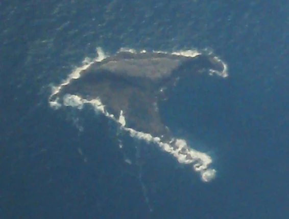
An aerial photograph looking down at a small, dark, rocky island surrounded by dark blue ocean water with white surf breaking against the shoreline.
An aerial view of Kārewa, Gannet Island, a protected wildlife sanctuary off the North Island of New Zealand.

Kārewa / Gannet Island history and protected-area timeline

Kārewa's history spans two distinct narratives: its deep geological past and its more recent ecological recognition. The underlying geology of the island dates back roughly half a million years, when a tuff ring eruption formed the foundation of what would become the present-day island. This eruption was an independent volcanic event, distinct from the older Alexandra and Okete volcanic episodes that shaped much of the surrounding mainland.

In modern times, the island's significance shifted from a curiosity of offshore geology to a focus of conservation attention. A 1980 census revealed that it held New Zealand's largest single breeding colony of Australasian gannets, with approximately 8000 breeding pairs. The colony's scale led to formal protection through wildlife sanctuary status, and BirdLife International subsequently recognised the island as an Important Bird Area. These steps cemented the island's place in New Zealand's protected natural heritage, even as it remains uninhabited by people.

Kārewa / Gannet Island landscape and geographic character

Kārewa / Gannet Island is a tiny, low-lying landform in the open sea, rising only 15 metres above sea level from a submarine base about 65 metres deep. Its modest height, combined with its exposure to heavy ocean swells, means the island is regularly washed over by waves. As a result, only around three square metres of the island retains any visible vegetation, and even that is restricted to communities of Prasiola algae, Tortula moss, Xanthoria lichens, and Xanthoparmelia lichens capable of surviving the salt-laden conditions.

The island's profile is the eroded remnant of an ancient tuff ring, whose softer outer materials have been worn away over time to leave a compact rocky core. It lies on the eastern edge of the North Taranaki Graben, a structural feature of the wider North Island geology that continues to influence the shape and stability of the surrounding seafloor. The contrast between the low island and the surrounding deep water gives the site a distinctive visual character from the air, as captured in the classic aerial view of the gannet-strewn rock.

Kārewa / Gannet Island ecosystems, habitats, and plant life

The natural character of Kārewa is defined less by lush vegetation than by the extreme conditions that shape life on the island. Persistent swell and salt spray leave only the hardiest organisms able to establish themselves on the small patch of stable ground where vegetation persists. Even there, the cover is made up primarily of algae such as Prasiola, mosses of the genus Tortula, and two genera of lichens, Xanthoria and Xanthoparmelia.

These species represent an ecological community adapted to constant exposure, sparse substrate, and nutrient inputs from seabird droppings. While the island's flora is minimal, the surrounding marine environment supports an exceptionally rich feeding zone for seabirds, sustaining large breeding populations over a very small area of land.

Kārewa / Gannet Island wildlife and species highlights

The wildlife significance of Kārewa / Gannet Island is overwhelmingly shaped by its gannet colony. The 1980 census identified the island as the location of New Zealand's largest single breeding colony of Australasian gannets, with roughly 8000 breeding pairs. This makes the island a cornerstone of the country's Australasian gannet population, particularly given how gannets concentrate their breeding on a relatively small number of offshore sites.

The dense concentration of breeding birds also contributes to conditions on the island itself, enriching the limited terrestrial habitat with nutrients. The colony's size and persistence were central to BirdLife International's decision to recognise the island as an Important Bird Area, placing it in the international framework used to identify the most critical sites for bird conservation. Beyond gannets, the island's remote and largely predator-free character provides additional refuge value for seabirds in the region.

Kārewa / Gannet Island conservation status and protection priorities

Kārewa / Gannet Island's conservation importance rests on the protection of one of New Zealand's most significant seabird colonies and on the preservation of its distinctive volcanic and ecological character. The island is formally protected as a wildlife sanctuary, a designation reflecting both the colony's size and the island's value as a refuge free from terrestrial predators.

Recognition by BirdLife International as an Important Bird Area further underscores the site's international conservation standing. This classification highlights the colony's contribution to the regional population of Australasian gannets and acknowledges the broader land-and-sea ecosystem that supports them. The combination of sanctuary status and international recognition places Kārewa firmly within New Zealand's protected natural heritage network, even though the island is uninhabited and physically small.

Top sights and standout views in Kārewa / Gannet Island

Kārewa / Gannet Island's most distinctive quality is the sheer scale of its Australasian gannet breeding colony, recognised in a 1980 census as the largest single colony of the species in New Zealand, with about 8000 breeding pairs. The colony's size is extraordinary relative to the island's footprint, and it has earned the site formal recognition as an Important Bird Area by BirdLife International.

Equally notable is the island's geological identity. As a half-million-year-old tuff ring remnant, distinctly younger than and compositionally different from the older Alexandra and Okete volcanic formations on the adjacent mainland, it provides a rare and well-defined piece of New Zealand's offshore volcanic record. Its combination of conservation significance, restricted-access setting, and geological distinctiveness gives Kārewa a uniquely concentrated natural value in the country's protected-area network.

Monthly climate preview

Long term temperature and precipitation patterns across twelve monthly periods

Kārewa / Gannet Island Climate Normals and Annual Weather Rhythm

Recorded measurements for Kārewa / Gannet Island outline a measured annual temperature range from twelve point four degrees Celsius to nineteen point five nine degrees Celsius alongside shifting monthly precipitation rates. Detailed analysis of these long term climate normals reveals complete monthly variations for the protected coordinate.
Annual mean16 °C
12 °C20 °C
Jan19°
Feb20°
Mar19°
Apr17°
May15°
Jun14°
Jul13°
Aug12°
Sep13°
Oct14°
Nov15°
Dec17°
Warmest month
February

19.6 °C

Coolest month
August

12.4 °C

Wettest month
June

4.3 mm/day

Driest month
January

2.3 mm/day

Park location guide

Geography guide, regional context, and park location map for Kārewa / Gannet Island

Kārewa / Gannet Island park geography, regions, and map view in New Zealand

Understand where Kārewa / Gannet Island sits in New Zealand through a broader geographic reading of the surrounding landscape, nearby location context, and its mapped position within the national park landscape.

How Kārewa / Gannet Island fits into New Zealand

New Zealand is an island nation in the southwestern Pacific Ocean comprising two main islands and numerous smaller islands. Located east of Australia across the Tasman Sea, it features varied topography with the Southern Alps running along the South Island and volcanic terrain on the North Island. The country was settled by Maori people between 1280 and 1350, followed by European exploration beginning in 1642, and became a Dominion in 1907 before gaining full independence in 1947.

Wider geography shaping Kārewa / Gannet Island in New Zealand

New Zealand lies in the southwestern Pacific Ocean, east of Australia across the Tasman Sea. The country consists of two main islands, the North Island and South Island, plus over 600 smaller islands. The North Island features volcanic plateaus and hills while the South Island is dominated by the Southern Alps mountain range. The country has a long coastline and is surrounded by the Pacific Ocean.

Map view of Kārewa / Gannet Island

Use this park location map to pinpoint Kārewa / Gannet Island in New Zealand, understand its exact geographic position, and read its mapped placement within the surrounding landscape more clearly.

Pigeon | © OpenStreetMap contributors

Location context for Kārewa / Gannet Island

Waikato

Visual exploration of offshore volcanic terrain and seabird habitats

Kārewa / Gannet Island Photos and Landscape Scenery

Photographic views reveal the rugged geological form and massive seabird colonies defining Kārewa / Gannet Island. Visual records help researchers examine the harsh coastal environment, exposed tuff ring remnants, and protected wildlife habitats across the open sea.

An aerial photograph looking down at a small, dark, rocky island surrounded by dark blue ocean water with white surf breaking against the shoreline.

Park atlas

Compare surrounding marine sanctuaries and coastal volcanic landscapes

Explore Protected Areas and Parks Near Kārewa / Gannet Island

Browse nearby national parks and protected coastal landscapes sharing the rich ecological context of Kārewa / Gannet Island. Comparing adjacent marine habitats and volcanic landforms reveals broader patterns across New Zealand conservation networks.
A wide, panoramic watercolor illustration showing layers of green rolling hills in the foreground, a line of green trees in the mid-ground, and soft purple and pink mountains in the background against a pale yellow sky.
Protected areaNew Zealand
About 47 km away#1 closest

East

Pirongia Forest Park: Mapped Geography and Protected Landscapes in the Waikato Region

Volcanic summits and native podocarp forest boundaries

Gain a deeper understanding of Pirongia Forest Park through its complex volcanic geology and dense native vegetation. This resource outlines the park's fragmented ridges, limestone stream systems, and its role as a biogeographic bridge within the Waikato landscape of New Zealand.

Area
167.7 km²
Established
1971
Relief
Mountain
Climate
Temperate
Protected landscapeWaikato
About 83 km away#2 closest

Southeast

Pureora Forest Park: Ancient Rainforests and Protected Mountain Landscapes in Waikato

Regional geography and mapped native forest boundaries

Pureora Forest Park represents a significant protected area in the central North Island of New Zealand, defined by its towering podocarp giants and complex volcanic terrain. The park serves as a prime example of an intact rainforest ecosystem, featuring dense broadleaf canopies, deep river valleys, and significant remnants of ancient forest history. Its geography, shaped by both geological upheaval and centuries of growth, provides an essential record of the natural heritage preserved across the Waikato and Manawatu-Whanganui regions.

Area
759.57 km²
Established
1978
Relief
Mountain
Water
Major water bodies
Watercolor painting of a green landscape featuring rolling hills, forested slopes, and a body of water in the foreground against a light, misty background.
Marine protected areaNew Plymouth District
About 96 km away#3 closest

South

Parininihi Marine Reserve: A Detailed Atlas of New Zealand's Coastal Marine Protected Area

Mapping the ecological sanctuary and reef geography in the New Plymouth District.

Gain insights into the geography of Parininihi Marine Reserve, a protected marine environment north-east of New Plymouth. This record outlines the reserve's structural features, from the iconic White Cliffs coastline to the complex underwater canyons and pinnacles of the Pariokariwa Reef. Learn about the seafloor terrain and the ecological distribution of invertebrate colonies and fish populations that define this crucial New Zealand marine reserve.

Area
18 km²
Established
2006
Relief
Lowland
Climate
Temperate
A flat-style digital illustration showing a winding river through a valley with pine trees, steep rock cliffs, and a waterfall under a soft sun.
Nature reserveAuckland
About 108 km away#4 closest

North

Puhinui Reserve: Protected Nature Reserve and Volcanic Geography in Auckland, New Zealand

Coastal wetlands, maar craters, and working agricultural lands

Explore the physical geography of Puhinui Reserve, a protected nature reserve in South Auckland. This site encompasses rare saltmarsh habitat, active volcanic maar features, and estuarine environments situated on the shores of the Manukau Harbour. Gain insight into the volcanic ash, alluvium, and peat soil structures that define this unique transitional landscape.

Area
1.99 km²
Established
1991
Relief
Lowland
Climate
Temperate
Regional parkAuckland Region
About 112 km away#5 closest

North

Waitākere Ranges Regional Park: Geographic Mapping of Auckland's Protected Coastal Forest

Volcanic terrain and expansive coastal wilderness boundaries

Examine the rugged geography of the Waitākere Ranges, spanning from sheer western sea cliffs to lush, regenerating forest valleys. This overview details the protected land, including volcanic rock formations, black sand surf beaches, and the inland reservoirs serving the Auckland region, highlighting its status as an ecologically critical heritage area.

Area
277.2 km²
Established
1895
Relief
Mountain
Climate
Subtropical
National parkNew Zealand
About 116 km away#6 closest

South

Whanganui National Park: Protected Wilderness Landscape and Geographic Context

Explore the mapped boundaries and natural terrain of this national park.

Whanganui National Park offers a unique blend of natural wilderness and significant cultural history, centered on the Whanganui River valley. This protected area safeguards one of New Zealand's most extensive lowland forest ecosystems, providing vital habitat and showcasing a landscape deeply intertwined with Māori traditions and historical settlement. Understanding its geographical setting and mapped protected boundaries reveals its importance as a distinct national park.

Area
742 km²
Established
1986
IUCN
II
Relief
Lowland
Regional parkWaikato Region
About 119 km away#7 closest

Northeast

Waharau Regional Park: Protected Coastal Forest and Hunua Ranges Gateway

Geographic landscape transition in the Waikato region

This protected area offers a deep look into the transition from native forest hill country to estuarine environments along the Firth of Thames. Spanning 170 hectares, it serves as a functional geographic corridor between the Hunua Ranges and the Hauraki Gulf, showcasing layered history and varied topography within the Waikato region.

Area
1.7 km²
Established
1979
Relief
Upland
Climate
Temperate
A pale, minimalist watercolor painting showing a grassy island or shoreline with a small cluster of trees, set against a quiet body of water and soft, distant rolling hills.
Protected areaAuckland Region
About 123 km away#8 closest

North

Motumānawa / Pollen Island: Protected Marine Reserve and Scientific Landscape in Auckland

A coastal shellbank island refuge within the Waitematā Harbour.

Motumānawa / Pollen Island is an essential protected area near the Rosebank Peninsula, serving as a sanctuary for native bird populations and estuarine vegetation. Its status as both a scientific and marine reserve highlights the importance of small-scale coastal conservation within a major metropolitan harbour landscape in New Zealand.

Established
2006
Relief
Lowland
Scope
Marine
Water
Water-dominated

Common questions about visiting, size, designation, and location context for Kārewa / Gannet Island

Kārewa / Gannet Island FAQs for park facts, access, geography, and protected area context

Find quick answers about Kārewa / Gannet Island, including protected-area facts, park geography, trail and visitor context, and how the park fits into its surrounding country and regional landscape.
MoriAtlas Explorer

Continue Your Protected Areas Search Across the Global Atlas

Deepen your exploration by continuing the structured search for national parks and protected areas worldwide. Utilize the comprehensive filtering capabilities to compare different conservation landscapes and refine your understanding of global park geography. Discover more about the distribution and characteristics of protected natural areas.

Global natural geography