
Mori Atlas logo
Nature reserveKastavenseen-Molkenkammersee

A tranquil mosaic of post-glacial lakes and transitional forest ecosystems in northeastern Germany

Kastavenseen-Molkenkammersee Protected Nature Reserve and Mapped Lake Geography in Brandenburg

(Naturschutzgebiet Kastavenseen-Molkenkammersee)

Kastavenseen-Molkenkammersee preserves a compact network of four interconnected lakes including Großer Kastavensee and Molkenkammersee. Situated in the Brandenburg region, this nature reserve protects a vital mosaic of open water, marginal wetlands, and surrounding forest. Its geography acts as a critical link in the broader conservation corridor that spans the border between the Uckermark and the Mecklenburg Lake District.

Brandenburg nature reserveUckermark lakesglacial lake districtlake and forest mosaicwetland habitatsreedbed and mire
A flat vector-style illustration of a forested valley with a central waterfall flowing into a winding river, framed by tall trees in the foreground and mountains in the background under a pale sky.

Kastavenseen-Molkenkammersee

Nature reserve

Park overview

Structured park overview, official facts, and landscape profile for Kastavenseen-Molkenkammersee

Kastavenseen-Molkenkammersee park facts, protected area profile, and essential visitor context

Review the core facts for Kastavenseen-Molkenkammersee, including designation, size, terrain, visitor scale, habitats, and operating context in one park-focused overview.

About Kastavenseen-Molkenkammersee

Kastavenseen-Molkenkammersee is a nature reserve in northeastern Brandenburg, Germany, dedicated to the protection of a compact cluster of lakes and their surrounding habitats. The site straddles the administrative boundary between the town of Fürstenberg/Havel in Landkreis Oberhavel and the town of Lychen in Landkreis Uckermark, placing it at the hinge between two of Brandenburg's most lake-rich rural districts.

The protected landscape is defined first by the four lakes themselves. The Großer Kastavensee and the Kleiner Kastavensee give the western part of the reserve its name and structure, while the Oberkastavensee adds an additional open-water component to the complex. Further east, separated from the Kastavensee group by forest and transitional wetland, the Molkenkammersee extends the reserve into a quieter and more secluded section. The varied shorelines, bays, and shallow margins of these lakes create a mosaic of aquatic and semi-aquatic habitats that are central to the area's ecological value.

Beyond the lakes themselves, the reserve encompasses the immediate catchments and forests that shape their water quality and ecological character. Mires, reeds, swamp woodland, and mixed forest form a buffer around the open water, while the wider surroundings remain comparatively low in intensity of land use. Together, these features create the kind of refuge that is increasingly rare across lowland Germany, where most lakes have been heavily altered by centuries of settlement, drainage, and fisheries management.

The reserve does not exist in isolation. To the west, across the state border in Mecklenburg-Vorpommern, the 10-hectare Naturschutzgebiet Zahrensee bei Dabelow extends the protected landscape into the neighboring Landkreis Mecklenburgische Seenplatte. To the east and south, a long sequence of Brandenburg reserves including the Kleine Schorfheide, Thymen, Küstrinchen, and the Stechlin area stitch together a continuous network of forest and lake protection. Within this network, Kastavenseen-Molkenkammersee contributes a small but ecologically meaningful node, focused on the specific qualities of the Kastavensee and Molkenkammersee waterbodies.

Quick facts and research context for Kastavenseen-Molkenkammersee

Designated as a Naturschutzgebiet under a regulation dated 7 July 2009, with an effective establishment date of 14 October 2009, Kastavenseen-Molkenkammersee carries the official site identifier 1621 and the World Database on Protected Areas record 389611.

The reserve covers roughly 268 hectares and is classified under IUCN Category IV as a Habitat/Species Management Area. It lies southeast of the state border with Mecklenburg-Vorpommern, with the L 15 state road running along its southern edge and the nearby protected area Zahrensee bei Dabelow extending the conservation corridor into the neighboring Landkreis Mecklenburgische Seenplatte.

Protection and recognition

Explore documented conservation data, official designations, and protected area records.

Kastavenseen-Molkenkammersee Protection Status and Natura 2000 Recognition

Kastavenseen-Molkenkammersee maintains documented protection records including Natura 2000 framework details and official database identifiers. Conservation analysts utilize these verified administrative designations to trace regional environmental management frameworks.
Park context

Deeper park guide and search-rich context for Kastavenseen-Molkenkammersee

Kastavenseen-Molkenkammersee history, landscape, wildlife, and travel context

Explore Kastavenseen-Molkenkammersee through its history, landscape character, ecosystems, wildlife, conservation priorities, cultural context, and seasonal travel timing in a structured park guide built for atlas discovery and search intent.

Why Kastavenseen-Molkenkammersee stands out

The reserve is best known for its tightly grouped system of four named lakes, whose shores and surrounding wetlands form the core of the protected landscape. Its character is shaped by clear, nutrient-sensitive waters set amid forest and mire, typical of the post-glacial lake districts that dominate the Brandenburg Uckermark and adjoining Mecklenburg border region. The site is also valued as a small but strategically placed piece of a much larger lake-protection network. Its position near the state border, between the Uckermark lakes to the east and the Mecklenburg Lake District to the west, makes it a connecting link in a regional conservation corridor that includes the Zahrensee bei Dabelow reserve and a string of other Naturschutzgebiete along the Havel and Lychen area.
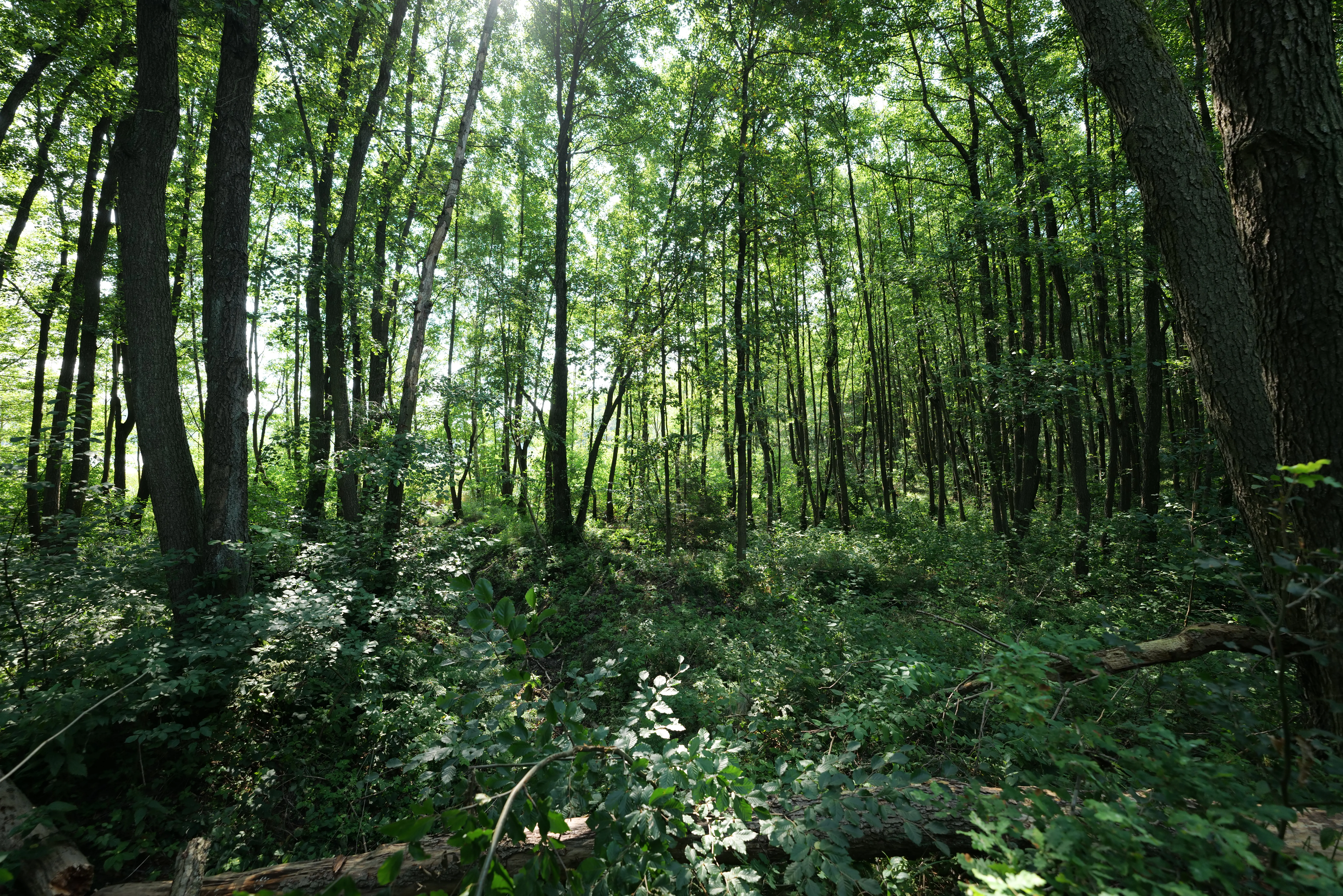
A dense, sun-dappled deciduous forest with tall trees and thick undergrowth.
Dense woodland within the Kastavenseen-Molkenkammersee nature reserve.

Kastavenseen-Molkenkammersee history and protected-area timeline

The area that would become Kastavenseen-Molkenkammersee was long part of the forested, lake-dotted landscape west of Lychen and south of the state border with Mecklenburg-Vorpommern. Like much of this region, it experienced gradual changes in land use over the twentieth century, but the four lakes and their immediate surroundings retained a degree of natural character that set them apart from more heavily modified waters nearby.

The decisive step toward formal protection came with a regulation of 7 July 2009, which placed the area under Naturschutz as a Naturschutzgebiet under Brandenburg law. Following the usual administrative procedure, the effective establishment date of the reserve was set at 14 October 2009, giving it the official site identifier 1621. The designation falls under IUCN Category IV, framing it as a Habitat/Species Management Area, consistent with the wider Brandenburg approach of using Naturschutzgebiete to safeguard specific habitat complexes rather than large wilderness blocks.

Since its establishment the reserve has been managed within the framework of Brandenburg's broader protected-area system, alongside the network of neighboring Naturschutzgebiete in the Uckermark and Oberhavel districts. Its compact size and the regional context, sitting near the smaller Zahrensee bei Dabelow on the Mecklenburg side, has kept it positioned as a small but purposeful element of cross-border lake conservation in northeastern Germany.

Kastavenseen-Molkenkammersee landscape and geographic character

The landscape of Kastavenseen-Molkenkammersee is shaped by the interplay of four closely linked lakes and the surrounding lowland terrain. The Großer Kastavensee, Kleiner Kastavensee, and Oberkastavensee form a chain of waterbodies that anchor the western part of the reserve, while the Molkenkammersee lies further east, separated by forest and transitional wetland. The varying sizes and shapes of these lakes create a characteristic shoreline pattern of long stretches of unbroken water interspersed with bays, inlets, and shallow margins.

The terrain itself is gently rolling, characteristic of the post-glacial morphology that defines the entire Uckermark and southern Mecklenburg Lake District. Forests of mixed deciduous and coniferous stands dominate the dry ground, with mires, reedbeds, and damp woodland filling the lower-lying transition zones around each lake. The result is a layered landscape in which the water surface, the open shore, and the wooded hinterland follow one another in close succession, often within only a short distance.

External features of the surrounding region also define the visual character of the reserve. The state road L 15 runs along its southern edge, marking a clear boundary between the protected area and the cultural landscape beyond. To the west the protected Zahrensee bei Dabelow continues a similar landscape into Mecklenburg-Vorpommern. Together, the four lakes, their forested margins, and the broader setting produce a tranquil, water-dominated scenery typical of the lake districts to the north of Berlin.

Kastavenseen-Molkenkammersee ecosystems, habitats, and plant life

The ecological identity of the reserve is built around the four lake systems and the gradients that radiate outward from their shorelines. The open waters themselves, often clear and nutrient-sensitive, support aquatic vegetation and fish communities typical of undisturbed lowland lakes in this part of Brandenburg. Where the water shallows toward the margins, floating-leaved and emergent plant communities take over, transitioning into reedbeds and sedge-dominated marsh.

Around these wetlands, damp woodlands and mires occupy the lower ground, giving way on drier sites to mixed forest dominated by pine and common broadleaf species. This sequence, water to marsh to swamp woodland to dry forest, creates a habitat mosaic in which each element influences the next. The result is a comparatively rich small-scale ecological structure, with aquatic, semi-aquatic, and terrestrial habitats all represented within the limits of the reserve.

Because the lakes are clustered tightly together, the reserve also functions ecologically as a single unit. Animals and plants associated with the water can move between the Großer Kastavensee, the Kleiner Kastavensee, the Oberkastavensee, and the Molkenkammersee along the connecting woodland and wetland corridors, while still benefiting from the protection afforded by the surrounding forest buffer. This connectedness is one of the key reasons the area was considered suitable for designation as a Habitat/Species Management Area under IUCN Category IV.

Kastavenseen-Molkenkammersee wildlife and species highlights

The wildlife value of the reserve is closely tied to the combination of open water, marginal wetland, and forest that defines its habitat mosaic. The lakes and their reedy margins provide resting and feeding habitat for waterbirds typical of the Brandenburg Uckermark, including ducks and other waterfowl that use such undisturbed lake-shore complexes in the breeding season as well as on migration. Bitterns, grebes, and similar marsh- and water-associated species are characteristic of the wetter parts of the reserve.

Around the open water, the forested fringes and mires support woodland birds and small mammals typical of north German mixed-forest landscapes. The damp woodland in particular offers nesting and foraging habitat for species that depend on quiet, waterlogged forest conditions rather than open agricultural land. Raptors such as common buzzards and other birds of prey typical of the Uckermark forests may also use the area as part of their wider hunting range.

The connectivity of the reserve adds to its importance for wildlife. The neighboring forest reserves, the Havel river headwaters to the south, and the broader lake-forest landscape stretching into Mecklenburg-Vorpommern all extend the effective range of many species well beyond the 268 hectares of the protected core, turning what is a small site into part of a much larger functional habitat network.

Kastavenseen-Molkenkammersee conservation status and protection priorities

Kastavenseen-Molkenkammersee is classified as a Habitat/Species Management Area under IUCN Category IV, reflecting its primary purpose of safeguarding specific habitats and species assemblages rather than maintaining a large-scale natural process area. The reserve protects a defined set of lakes, their shorelines, and the surrounding forest and mire in a region where historical land use has shaped most other waterbodies more heavily.

Its conservation significance derives from the relative intactness of this particular lake cluster and from the ecological continuity it maintains with neighboring protected areas. The Zahrensee bei Dabelow reserve lies just across the state border in the Landkreis Mecklenburgische Seenplatte, while to the east and south the Brandenburg reserves of Kleine Schorfheide, Thymen, Küstrinchen, and the larger Stechlin complex extend the network of protected lakes and forests. Together, these sites form a continuous conservation backbone across the Uckermark and southern Mecklenburg borderland.

By keeping the waters, wetlands, and surrounding forest buffered against the pressures faced elsewhere in the region, including forestry intensification, drainage, and recreational development along the shoreline, the reserve secures a refuge for lake-dependent biodiversity. Even at a comparatively small size of 268 hectares, it represents a meaningful contribution to Brandenburg's network of lake and forest protection.

Kastavenseen-Molkenkammersee cultural meaning and human context

The reserve lies within a region whose cultural identity is closely tied to water and forest. The towns of Lychen and Fürstenberg/Havel, which share jurisdiction over the protected area, both grew up as small lacustrine settlements, historically oriented toward fishing, timber, and later the waterway connections that linked the Uckermark lakes to the Havel and Berlin. The presence of numerous preserved lake complexes in the surrounding countryside reflects a long, if uneven, history of coexistence between human settlement and the natural water landscape.

The landscape around the reserve retains this character even today. Small settlements such as Retzow, a part of Lychen, and Neuthymen, a residential locality within Fürstenberg/Havel, sit at the edges of the protected area, and the L 15 state road marks the transition between rural habitation and the more strictly protected lake-and-forest zone. While the reserve itself is a quiet, lightly visited corner of the region, its setting is a reminder of the broader cultural geography of the southern Uckermark and the Havel headwaters.

Top sights and standout views in Kastavenseen-Molkenkammersee

The defining highlights of the reserve are the four named lakes at its core. The Großer Kastavensee, Kleiner Kastavensee, Oberkastavensee, and Molkenkammersee each contribute a slightly different dimension to the protected mosaic, from broad open water to more secluded bays, and from relatively exposed shorelines to sheltered, reed-fringed margins.

Equally important is the reserve's role as a node within a wider conservation landscape. The transition from these lakes into surrounding forest and mire, the cross-border link with the Zahrensee bei Dabelow reserve in Mecklenburg-Vorpommern, and the connections with the larger Uckermark and Havel-area protected sites together make Kastavenseen-Molkenkammersee a meaningful, if compact, contributor to northeastern Germany's lake-protection network.

Best time to visit Kastavenseen-Molkenkammersee

The reserve is best appreciated during the warmer months, when the lake margins are biologically active and the surrounding forest is in full leaf. Late spring into early summer brings the most active breeding and feeding conditions for waterbirds and forest wildlife, while late summer and early autumn offer quieter conditions, more muted light over the water, and a chance to observe the lake landscape as it transitions into the calmer character of the cooler season.

Winter visits, where conditions and access allow, reveal a different face of the reserve. The frozen or partially frozen lakes, bare deciduous trees, and snow-dusted forest edges emphasize the simple, open structure of the landscape and make the shoreline pattern of the four lakes particularly easy to read. At any season, the experience is shaped more by stillness and the contrast between water, forest, and wetland than by dramatic seasonal events, so visitors who value quiet encounters with a lowland lake landscape will find the reserve appealing throughout the year.

Monthly climate preview

Long-term representative coordinate data showing twelve-month temperature and precipitation patterns

Kastavenseen-Molkenkammersee Climate Normals and Measured Annual Temperature Rhythm

Kastavenseen-Molkenkammersee exhibits a measured annual temperature and precipitation rhythm across twelve months of recorded coordinates. Exploring the complete monthly climate normals reveals detailed long-term averages for representative sample points.
Annual mean9 °C
-1 °C19 °C
Jan-1°
Feb
Mar
Apr
May13°
Jun17°
Jul19°
Aug19°
Sep15°
Oct
Nov
Dec
Warmest month
July

19.3 °C

Coolest month
January

-0.8 °C

Wettest month
July

2.5 mm/day

Driest month
April

1.1 mm/day

Park location guide

Geography guide, regional context, and park location map for Kastavenseen-Molkenkammersee

Kastavenseen-Molkenkammersee park geography, regions, and map view in Germany

Understand where Kastavenseen-Molkenkammersee sits in Germany through a broader geographic reading of the surrounding landscape, nearby location context, and its mapped position within the national park landscape.

How Kastavenseen-Molkenkammersee fits into Germany

Germany is a federal republic in Western and Central Europe with a population of over 83 million across sixteen constituent states. It is Europe's largest economy by nominal GDP and a major global exporter and importer. The capital is Berlin, and the country borders Denmark, Poland, Czech Republic, Austria, Switzerland, France, Luxembourg, Belgium, and the Netherlands.

Wider geography shaping Kastavenseen-Molkenkammersee in Germany

Germany is located in Western and Central Europe, spanning 357,022 km². It borders Denmark to the north, Poland and the Czech Republic to the east, Austria and Switzerland to the south, and France, Luxembourg, Belgium, and the Netherlands to the west. The country has coastlines on the Baltic Sea and North Sea to the north, with the Alps located in the southern region.

Map view of Kastavenseen-Molkenkammersee

Use this park location map to pinpoint Kastavenseen-Molkenkammersee in Germany, understand its exact geographic position, and read its mapped placement within the surrounding landscape more clearly.

Pigeon | © OpenStreetMap contributors

Location context for Kastavenseen-Molkenkammersee

Brandenburg

Visual reference for glacial lakes, shorelines, and forest habitats

Kastavenseen-Molkenkammersee Photos, Landscapes, and Protected Scenery

Visual documentation of Kastavenseen-Molkenkammersee reveals the intricate mosaic of four interconnected lakes, marginal wetlands, and surrounding lowland forests. Examining these protected area views provides a clearer understanding of post-glacial terrain and fragile aquatic habitats across the region.

A dense, sun-dappled deciduous forest with tall trees and thick undergrowth.

Park atlas

Compare adjacent lake networks and surrounding regional reserves

Other Protected Areas and Parks Near Kastavenseen-Molkenkammersee

Browse nearby protected areas and connected forest landscapes located across the surrounding region. Comparing these regional nature reserves provides a deeper look into the post glacial lake ecosystems of northeastern Germany.
Nature reserveBrandenburg
About 14 km away#1 closest

Southeast

Kleine Schorfheide Nature Reserve: Brandenburg Protected Area and Landscape Atlas

Mapped terrain, river floodplains, and forest mosaic in Northern Brandenburg

Spanning over 73 square kilometres, Kleine Schorfheide stands as a significant nature reserve in Brandenburg. It protects a vast, contiguous mosaic of open former military training lands, the natural Havel river floodplain, and the Himmelpforter Heide forest, creating a distinct regional landscape defined by its varied terrain and interconnected lake systems.

Area
73.75 km²
Established
1994
IUCN
IV
A soft watercolor painting of undulating green hills and forest foliage against a white background.
Nature reserveBrandenburg
About 24 km away#2 closest

Southeast

Buchheide Nature Reserve: Glacial Terrain and Forest Conservation in Brandenburg

Base-rich moraine and waterlogged habitat geography

The Buchheide nature reserve in Brandenburg offers a distinct case study in post-glacial landscape ecology. Centered on lime-rich ground moraine and seasonal wetness, the area supports specialized forest habitats. This site provides a clear view into the interactions between ancient geological formations, riparian zones, and current regional conservation strategies across the Uckermark.

Area
5.66 km²
Established
1990
IUCN
IV
Nature reserveBrandenburg
About 26 km away#3 closest

East

Zerweliner Koppel Nature Reserve: Mapped Protected Landscapes in the Brandenburg Region

A preserved mosaic of woodland and lakeside habitats

Located in the Uckermark district, Zerweliner Koppel represents a vital protected area characterized by its interweaving of wet and dry habitats. This nature reserve supports an array of ecosystems ranging from nutrient-poor lakes and calcareous fens to oak and beech forests, providing a stable refuge for diverse wildlife species in northeastern Germany.

Area
1.93 km²
Established
2005
IUCN
IV
Relief
Lowland
A soft, artistic watercolor painting of a green landscape leading to a lake, with rolling hills in the background and soft morning or evening light.
Nature reserveBrandenburg
27 km away#4 closest

Southeast

Bollwinwiesen/Großer Gollinsee Nature Reserve: Brandenburg Protected Area Atlas

Oligotrophic lake chains and peat-forming mire landscapes

Bollwinwiesen/Großer Gollinsee forms a critical ecological anchor within the Schorfheide-Chorin Biosphere Reserve. The area preserves a distinct glacial mosaic where clear water, Sphagnum-dominated mires, and traditional wet meadows converge to create a protected landscape defined by its high ecological integrity and historic conservation status.

Area
9.075 km²
Established
1990
IUCN
IV
Relief
Lowland
Watercolor painting of a gentle green hilly landscape with a foreground of soft pink and purple tones, set against a light background.
Nature reserveLandkreis Uckermark
32 km away#5 closest

Southeast

Endmoränenlandschaft bei Ringenwalde: Nature Reserve and Glacial Landscape Exploration

Geomorphology and protected forest geography in Landkreis Uckermark

This nature reserve stands as a textbook example of end moraine morphology shaped by Pleistocene glaciers. The area serves as a vital component of the broader Schorfheide-Chorin Biosphere Reserve, preserving a distinct system of forested ridges, basin lakes, and varied micro-relief that offers deep insight into the natural history of the Brandenburg region.

Area
5.69 km²
Established
1990
IUCN
IV
A watercolor painting depicting a calm wetland landscape with thin, bare tree trunks rising from the water, backed by soft green rolling hills and lush vegetation.
Nature reserveBrandenburg
32 km away#6 closest

East

Arnimswalde Nature Reserve: Mapped Protected Lake and Forest Ecosystems in Brandenburg

Glacial landscape and Natura 2000 protected territory

Arnimswalde represents a significant protected nature reserve within the Brandenburg region of Germany. This detailed geographic profile covers the reserve's unique glacial lake basins, peat-stained dystrophic waters, and diverse forest communities, offering a structured view of its contribution to regional biodiversity and the broader Schorfheide-Chorin conservation framework.

Area
14.069 km²
Established
1990
IUCN
IV
Watercolor painting of a landscape with a lake, trees, and distant hills
National parkMecklenburg-Vorpommern
33 km away#7 closest

Northwest

Müritz National Park: Explore Protected Beech Forests and Glacial Lakelands in Mecklenburg-Vorpommern

Germany's largest national park: mapped boundaries and terrain.

Müritz National Park represents a significant protected landscape within northeastern Germany's Mecklenburg-Vorpommern region. Its expansive territory encompasses not only Germany's largest lake, Müritz, but also substantial tracts of ancient beech forests awarded UNESCO World Heritage status. Users can explore the park's glacial terrain, its intricate network of lakes and wetlands, and understand its position within the regional geography, making it a key destination for structured atlas-based discovery of German protected areas.

Area
318 km²
Established
1990
IUCN
II
Relief
Lowland
Nature reserveBrandenburg
34 km away#8 closest

Southeast

Winkel Nature Reserve: Glacial Landscape and Wetland Geography in Brandenburg, Germany

Mapping kettle-hole basins and moraine terrain

Winkel Nature Reserve serves as a vital protected area for studying the hydrological character of the Uckermark. The reserve features a dense network of small, water-filled kettle holes formed by melting glacial ice. This geographic record explores the interconnected wetland habitats and ground moraine surfaces that define this sensitive protected landscape in northeastern Germany.

Area
1.45 km²
Established
1990
IUCN
IV

Common questions about visiting, size, designation, and location context for Kastavenseen-Molkenkammersee

Kastavenseen-Molkenkammersee FAQs for park facts, access, geography, and protected area context

Find quick answers about Kastavenseen-Molkenkammersee, including protected-area facts, park geography, trail and visitor context, and how the park fits into its surrounding country and regional landscape.
MoriAtlas Explorer

Continue Your Protected Areas Search Across the Global Atlas

Deepen your exploration by continuing the structured search for national parks and protected areas worldwide. Utilize the comprehensive filtering capabilities to compare different conservation landscapes and refine your understanding of global park geography. Discover more about the distribution and characteristics of protected natural areas.

Global natural geography