

Mori Atlas logo
Wildlife reserveKathai Conservation Park

Understanding the geography of Northside Hill and the Uley catchment basin protected landscape

Kathai Conservation Park: A Protected Wildlife Reserve in South Australia's Eyre Peninsula

Kathai Conservation Park sits as a focused wildlife reserve within the Uley catchment basin on the southern Eyre Peninsula of South Australia. Covering roughly 81 hectares, this protected area preserves an open mallee forest featuring coastal white mallee and regionally rare purple-flowered mallee. The central topographic anchor of the site is the 145-metre Northside Hill, which creates significant habitat variety within the broader agricultural terrain of the region.

conservation parkEyre Peninsulamallee woodlandcoastal white malleepurple-flowered malleedryland tea-tree

Kathai Conservation Park

Wildlife reserve

Park overview

Structured park overview, official facts, and landscape profile for Kathai Conservation Park

Kathai Conservation Park park facts, protected area profile, and essential visitor context

Review the core facts for Kathai Conservation Park, including designation, size, terrain, visitor scale, habitats, and operating context in one park-focused overview.

About Kathai Conservation Park

Kathai Conservation Park is a compact but ecologically focused reserve situated on the Eyre Peninsula in South Australia, a short distance south-west of Port Lincoln. Although its area is small by national park standards, the reserve plays a clearly defined role in protecting habitat within the Uley catchment basin, a landscape that has been heavily modified by agriculture and settlement. The park's identity is closely tied to Northside Hill, an isolated rise of about 145 metres above sea level that anchors the reserve and gives it both its visual character and its Aboriginal-derived name.

The vegetation of Kathai is a textbook example of Eyre Peninsula mallee country. An open canopy of coastal white mallee extends across much of the protected area, while the understorey is dominated by tall dryland tea-tree shrubs that create a layered habitat structure typical of the region. Within this broadly characteristic landscape, the park also supports the purple-flowered mallee, a species considered regionally rare, which adds a notable element of botanical distinctiveness. The park therefore functions both as a representative sample of local mallee woodland and as a refuge for a species of conservation interest.

Administratively, Kathai Conservation Park was constituted in 1985 under South Australia's National Parks and Wildlife Act 1972 and is managed by the state's Department for Environment and Water. It carries an IUCN Category III classification, recognising it as a natural monument or feature worthy of specific protection. Taken together, its catchment protection role, its mallee vegetation, its regionally rare flora, and its connection to an Aboriginal place name make Kathai a reserve with a clear sense of place and purpose on the southern Eyre Peninsula.

Quick facts and research context for Kathai Conservation Park

Kathai Conservation Park lies on the Eyre Peninsula in South Australia, about 5 kilometres south-west of Port Lincoln within the locality of Duck Ponds. The park covers approximately 81 hectares of crown land in the Hundred of Lincoln and is managed by the South Australian Department for Environment and Water. It was gazetted on 7 November 1985 under the National Parks and Wildlife Act 1972 to protect habitat and wildlife within the Uley catchment basin.

The reserve is classed as an IUCN Category III area, recognising it as a natural monument or feature of conservation significance. Its central landform is Northside Hill, reaching about 145 metres above sea level, and the park takes its official name from the Aboriginal word for this hill.

Protection and recognition

Terrestrial protected area management scope and recognition data

Kathai Conservation Park Protection Status And Documented Scope

Kathai Conservation Park maintains a documented terrestrial protection status within the regional conservation network. Structured facts outline the recorded designation framework and management scope associated with the protected landscape.

Protection details

Protection scope
Terrestrial
Park context

Deeper park guide and search-rich context for Kathai Conservation Park

Kathai Conservation Park history, landscape, wildlife, and travel context

Explore Kathai Conservation Park through its history, landscape character, ecosystems, wildlife, conservation priorities, cultural context, and seasonal travel timing in a structured park guide built for atlas discovery and search intent.

Why Kathai Conservation Park stands out

Kathai Conservation Park is best known for protecting an open mallee forest on the Eyre Peninsula, dominated by coastal white mallee over a tall shrub understorey of dryland tea-tree. Its defining feature is Northside Hill, an elevated landform of about 145 metres that gave the park its name 'Kathai,' derived from the Aboriginal word for the hill itself. The park is also recognised as part of the broader effort to safeguard the Uley catchment basin, one of the important hydrological landscapes of southern Eyre Peninsula. The occurrence of the regionally rare purple-flowered mallee within its boundaries adds a layer of botanical distinction that elevates the reserve's conservation profile.

Kathai Conservation Park history and protected-area timeline

Kathai Conservation Park was formally constituted on 7 November 1985 under South Australia's National Parks and Wildlife Act 1972. The park was created with the explicit purpose of protecting and conserving habitat and wildlife within the Uley catchment basin, an area of southern Eyre Peninsula that has long been shaped by both natural processes and human land use.

Before its gazetting, the area was identified for protection under the proposed name Northside Hill Conservation Park, after the prominent hill that defines much of the reserve. However, the Geographic Names Board ultimately approved 'Kathai' as the official name, recognising the Aboriginal name for the same hill. This choice linked the new conservation park to the deeper cultural and linguistic heritage of the region and gave the reserve a name with local significance beyond its colonial-era identifiers.

Since its establishment, the park has remained a small but stable component of South Australia's protected-area network, managed by the Department for Environment and Water. Its ongoing role reflects the original intention of its 1985 creation: to maintain habitat and wildlife values within the Uley catchment basin through targeted, small-scale protection rather than large-scale landscape reservation.

Kathai Conservation Park landscape and geographic character

The landscape of Kathai Conservation Park is shaped above all by Northside Hill, a prominent rise of about 145 metres above sea level that anchors the reserve and gives it much of its topographic identity. Although the park covers only a modest area of roughly 81 hectares, the hill creates a clear sense of elevation in an otherwise low-lying coastal landscape along the southern Eyre Peninsula near Port Lincoln. The hill itself provides the structural framework around which the protected area was drawn.

Surrounding this central landform, the terrain consists of gently undulating ground within the Hundred of Lincoln, falling away toward the broader Uley catchment basin. The result is a compact mosaic of upper-slope, slope, and lower-ground environments within a small reserve, offering microhabitat variation that supports the characteristic vegetation of the area. The park's location close to the coast also subjects it to the milder, more maritime influence typical of the southern Eyre Peninsula, shaping soils and exposure patterns across the hill and its surrounds.

Kathai Conservation Park ecosystems, habitats, and plant life

Kathai Conservation Park preserves a representative example of Eyre Peninsula mallee vegetation, with an open canopy of coastal white mallee spreading across most of the reserve. Beneath this canopy, the understorey is dominated by tall shrubs of dryland tea-tree, which together give the park its characteristic layered structure of slender eucalypts over a denser shrub layer. This vegetation pattern is closely associated with the sandy, often nutrient-poor soils and Mediterranean-style climate of the southern Eyre Peninsula.

Beyond its broad habitat character, the park holds particular botanical significance through the presence of the purple-flowered mallee, a species considered regionally rare within South Australia. Its occurrence within the protected boundaries gives the reserve an additional conservation role beyond the protection of common mallee woodland. The combination of widespread coastal white mallee, a well-developed tea-tree understorey, and a rare mallee species defines the ecological identity of Kathai and gives it disproportionate botanical value for its small size.

Kathai Conservation Park wildlife and species highlights

The wildlife value of Kathai Conservation Park is closely tied to the habitat features it was established to protect. Its open mallee woodland and tea-tree shrub understorey provide shelter and foraging resources for a range of bird and small mammal species typical of southern Eyre Peninsula mallee environments. The combination of canopy and shrub layers creates structural diversity that supports nectar-feeding birds, insectivores, and other fauna associated with mallee and heath communities.

While the park's small footprint limits populations of larger or more wide-ranging species, its position within the Uley catchment basin gives it a broader conservation function for wildlife movement and habitat connectivity on the southern peninsula. By safeguarding a representative patch of native mallee vegetation in an otherwise heavily modified agricultural landscape, Kathai contributes to the maintenance of ecological processes and habitat availability for native fauna at a regional scale.

Kathai Conservation Park conservation status and protection priorities

Kathai Conservation Park was established specifically to protect and conserve habitat and wildlife within the Uley catchment basin, making conservation its core purpose from inception. Its designation reflects a recognition that, even small, well-placed reserves can play a meaningful role in maintaining ecological function within landscapes that have otherwise been substantially altered by agriculture and settlement.

The park holds an IUCN Category III classification, identifying it as a natural monument or feature of conservation significance. This status emphasises the importance of the specific features it protects, rather than viewing the park as part of a large, contiguous wilderness block. The occurrence of the regionally rare purple-flowered mallee adds weight to this reserve-level significance, demonstrating that Kathai supports species of conservation interest in addition to broader habitat values.

Managed by the South Australian Department for Environment and Water, Kathai is part of the state's broader network of small reserves that together maintain habitat representation across the Eyre Peninsula. In this context, the park functions as a focused conservation site: small in size, but carrying a defined purpose related to catchment protection, mallee habitat retention, and the safeguarding of regionally rare flora.

Kathai Conservation Park cultural meaning and human context

The cultural identity of Kathai Conservation Park is closely bound to the Aboriginal place name that was ultimately chosen for the reserve. Before its gazetting, the area had been proposed as Northside Hill Conservation Park, reflecting the colonial-era name of the central landform. However, the Geographic Names Board approved 'Kathai' instead, adopting the Aboriginal name for the same hill as the official title of the reserve.

This naming decision preserves and elevates an Indigenous place name within South Australia's formal protected-area system, linking the park's identity to the longer Indigenous history of land and language on the Eyre Peninsula. While detailed cultural information about the site itself is limited in publicly available sources, the recognition of 'Kathai' as the official name gives the park a cultural dimension that complements its ecological role and connects the reserve to the broader Aboriginal heritage of the region.

Top sights and standout views in Kathai Conservation Park

Kathai Conservation Park's standout features include its location on the southern Eyre Peninsula near Port Lincoln, the prominence of Northside Hill as a defining landform, and its clear ecological focus on the Uley catchment basin. The reserve's deliberately small footprint reflects a targeted approach to habitat protection in an otherwise heavily modified landscape, and its IUCN Category III status recognises the natural feature values it safeguards.

Equally important are the park's botanical highlights: an open coastal white mallee canopy over a tall dryland tea-tree understorey, and the presence of the regionally rare purple-flowered mallee. The official adoption of the Aboriginal place name 'Kathai' in place of the earlier 'Northside Hill' proposal adds a cultural highlight that gives the reserve a distinctive and enduring identity.

Best time to visit Kathai Conservation Park

Kathai Conservation Park sits on the southern Eyre Peninsula, where the climate follows the typical Mediterranean pattern of the region: mild, wetter winters and warm, dry summers. Autumn and spring are generally the most comfortable seasons for outdoor activity, when temperatures are moderate and the mallee vegetation, including flowering eucalypts such as coastal white mallee and the purple-flowered mallee, is often at its most visually expressive.

Winter brings cooler conditions and the bulk of the region's annual rainfall, which can make tracks underfoot heavier or muddy, though the cooler temperatures and greener vegetation appeal to many visitors. Summer tends to be drier and warmer, with longer days but stronger heat, and is generally less comfortable for extended time in the field. As with any visit to a small, weather-exposed reserve, local conditions and forecasts should be considered; the park itself remains a year-round destination for those interested in mallee vegetation and Eyre Peninsula scenery.
Monthly climate preview

Examining representative point measurements across monthly average extremes and rainfall totals

Kathai Conservation Park Climate Normals, Long-Term Temperature and Precipitation Rhythm

Kathai Conservation Park displays measured long-term temperature swings alongside distinct monthly precipitation variations across its representative coordinate. Reviewing the complete twelve-month climatology dataset clarifies annual meteorological patterns and broader regional environmental conditions.
Annual mean16 °C
14 °C19 °C
Jan19°
Feb19°
Mar19°
Apr17°
May16°
Jun15°
Jul14°
Aug14°
Sep14°
Oct15°
Nov16°
Dec18°
Warmest month
February

19.4 °C

Coolest month
August

13.6 °C

Wettest month
June

2.3 mm/day

Driest month
January

0.5 mm/day

Park location guide

Geography guide, regional context, and park location map for Kathai Conservation Park

Kathai Conservation Park park geography, regions, and map view in Australia

Understand where Kathai Conservation Park sits in Australia through a broader geographic reading of the surrounding landscape, nearby location context, and its mapped position within the national park landscape.

How Kathai Conservation Park fits into Australia

Australia is a constitutional monarchy and federal parliamentary democracy comprising six states and ten territories. With a population of nearly 28 million, it is one of the world's most urbanised countries, with most people concentrated on the eastern seaboard. The country has a high Human Development Index and is known for its cultural diversity, ancient Aboriginal heritage, and unique wildlife.

Wider geography shaping Kathai Conservation Park in Australia

Australia occupies the entire Australian continent, the island of Tasmania, and numerous smaller islands. It is the world's flattest and driest inhabited continent, featuring vast deserts in the interior (the Outback), tropical rainforests along the eastern coast, and a coastline bordering the Indian and Pacific Oceans.

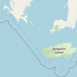
Map view of Kathai Conservation Park

Use this park location map to pinpoint Kathai Conservation Park in Australia, understand its exact geographic position, and read its mapped placement within the surrounding landscape more clearly.

Pigeon | © OpenStreetMap contributors

Location context for Kathai Conservation Park

South Australia
Park atlas

Discover related regional reserves and surrounding coastal mallee landscapes.

Explore Protected Areas and Parks Near Kathai Conservation Park

Continue geographic comparison by browsing other protected areas located across the surrounding Eyre Peninsula region. Each connected reserve offers distinct terrain features and native vegetation patterns that complement the local catchment context.
National parkSouth Australia
5.7 km away#1 closest

South

Lincoln National Park National Park: Mapped Protected Area and Geographic Landscape Identity

South Australia's protected landscape with detailed park boundaries.

Gain a comprehensive atlas perspective on Lincoln National Park, a designated national park in South Australia. This resource details the park's mapped boundaries, offering clear geographic context and highlighting its role as a protected landscape. Understand its place within the regional geography of South Australia, providing essential data for landscape exploration and atlas-based research.

Area
216.38 km²
Established
1941
IUCN
II
Relief
Upland
National parkSouth Australia
26 km away#2 closest

West

Coffin Bay National Park: Protected Landscape and Geographic Context in South Australia

Explore the mapped boundaries and regional geography of this national park.

Coffin Bay National Park presents a distinct protected landscape within South Australia, offering a valuable point of entry for geographic discovery. This page details the park's national park designation and its mapped territory, crucial for understanding its role in Australia's atlas of natural areas. Delve into the park's specific geographic context and the outlines of its protected lands, providing a clear picture of its landscape within the state's broader terrain.

Area
309.76 km²
Established
1982
IUCN
II
Relief
Lowland
Nature reserveSouth Australia
93 km away#3 closest

West

Greenly Island Conservation Park: Geography and Protected Nature Reserve Map

Island protected area off the South Australian Eyre Peninsula.

This offshore nature reserve preserves an exposed, rocky island environment in the Southern Ocean. As a protected area for marine mammal haul-out sites, it provides a unique look at isolated coastal terrain and strict conservation management along the western shoreline of South Australia.

Area
1.68 km²
Established
1967
IUCN
Ia
Relief
Lowland
Wildlife reserveSouth Australia
95 km away#4 closest

North

Hincks Conservation Park: Protected Wildlife Reserve in South Australia

Mapping regional biodiversity and conservation landscapes

Hincks Conservation Park functions as a key protected area within the semi-arid coastal hinterland of the Eyre Peninsula. This reserve preserves an essential fragment of native vegetation against a surrounding backdrop of agricultural development. The site highlights the importance of managed land corridors in maintaining ecological connectivity across the central-eastern reaches of South Australia.

Area
8.78 km²
Established
1941
IUCN
VI
Relief
Lowland
Nature reserveSouth Australia
About 110 km away#5 closest

Northwest

Cap Island Conservation Park: Nature Reserve and Offshore Marine Habitat in South Australia

Coastal granite island and protected seabird breeding landscape.

Situated off the coast of the Eyre Peninsula, Cap Island Conservation Park is a protected nature reserve serving as a critical sanctuary for pinnipeds and nesting seabirds. Its unique geological profile, featuring a granite base and calcarenite cap, creates a rugged offshore environment shaped by marine erosion and salt-tolerant vegetation. The reserve highlights the significance of isolated island ecosystems within the broader geography of South Australia.

Area
0.09 km²
Established
1967
IUCN
Ia
Relief
Lowland
National parkAustralia
About 110 km away#6 closest

Southeast

Dhilba Guuranda-Innes National Park: A Detailed Look at Its Australian Protected Landscape

Explore the park's mapped geography and natural terrain.

This section offers a focused atlas exploration of Dhilba Guuranda-Innes National Park, detailing its significance as a protected natural area within Australia. Gain understanding of its unique geographic characteristics, mapped boundaries, and its contribution to the country's diverse natural landscapes. This provides detailed context for anyone interested in Australia's protected land inventory and regional geography.

Area
94.15 km²
Established
1970
Visitors
200K annual
Relief
Mixed relief
National parkAustralia
About 110 km away#7 closest

Southeast

Innes National Park National Park: Mapped Protected Landscape and Regional Geography

Explore its geographic setting and natural terrain.

Delve into the protected landscape and geographic particulars of Innes National Park. This entry provides detailed insights into its mapped boundaries and the surrounding natural terrain within Australia. Understanding Innes National Park's place in the broader geographic atlas helps users compare and contrast protected areas across different regions and nations.

IUCN
II
Protected areaSouth Australia
About 115 km away#8 closest

East

Carribie Conservation Park: Mapped Geography and Protected Area Overview in South Australia

Ecological terrain and native vegetation remnants on the Yorke Peninsula

Carribie Conservation Park is a 19-hectare protected area situated on the southern Yorke Peninsula of South Australia. The terrain consists of an undulating sandy plain characterized by two contrasting vegetation zones: a northern mallee scrub and a southern sheoak and tea-tree woodland. As a formal conservation site, it provides a vital window into the original botanical character of the region.

Area
0.19 km²
Established
1968
IUCN
III
Relief
Lowland

Common questions about visiting, size, designation, and location context for Kathai Conservation Park

Kathai Conservation Park FAQs for park facts, access, geography, and protected area context

Find quick answers about Kathai Conservation Park, including protected-area facts, park geography, trail and visitor context, and how the park fits into its surrounding country and regional landscape.
MoriAtlas Explorer

Continue Your Protected Areas Search Across the Global Atlas

Deepen your exploration by continuing the structured search for national parks and protected areas worldwide. Utilize the comprehensive filtering capabilities to compare different conservation landscapes and refine your understanding of global park geography. Discover more about the distribution and characteristics of protected natural areas.

Global natural geography